

Surf Forecasts:

How big are the waves at Sands today (12 Jul):
- Morning surf: Morning surf (12 Jul, local time) - 1ft (0.3m), 9s period with SE swell.
- Afternoon surf: Afternoon surf (12 Jul, local time) - 2ft (0.6m), 5s period with ESE swell.
- Evening surf: Evening surf (12 Jul, local time) - 2ft (0.6m), 5s period with ESE swell.
The current surf forecast for Sands at 9AM is: 0.3m 9s primary swell from a Southeast direction and 0.3m 6s secondary swell from a South direction, 0.5m 5s secondary swell from a East direction (forecast issued at 01:00am July 12). The wind direction is predicted to be cross-onshore.
| Time (EDT) & Date | Wave Height | Wave Period |
|---|---|---|
| Morning (12 Jul) | 1ft (0.3m) | 9s |
| Afternoon (12 Jul) | 2ft (0.6m) | 5s |
| Evening (12 Jul) | 2ft (0.6m) | 5s |
Table - waves today at Sands. (Swell directed towards the surf break)
Short Range ForecastMostly dry. Warm (max 33°C on Tue afternoon, min 21°C on Mon morning). Winds increasing (light winds from the SSW on Sun night, fresh winds from the WSW by Tue night). | ||||||||||||||||||||||||
Sunday 12 | Monday 13 | Tuesday 14 | ||||||||||||||||||||||
2 AM | 5 AM | 8 AM | 11 AM | 2 PM | 5 PM | 8 PM | 11 PM | 2 AM | 5 AM | 8 AM | 11 AM | 2 PM | 5 PM | 8 PM | 11 PM | 2 AM | 5 AM | 8 AM | 11 AM | 2 PM | 5 PM | 8 PM | 11 PM | |
Swell Height Map |  | 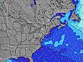 |  |  | 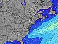 |  |  | 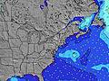 |  | |||||||||||||||
Wave Height (m) Direction Period (s) | SE 10 | SE 9 | SE 9 | ESE 5 | ESE 5 | ESE 5 | SE 10 | ESE 5 | ESE 6 | ESE 6 | SE 9 | SE 9 | SE 9 | ESE 9 | ESE 9 | ESE 8 | SE 9 | ESE 7 | SE 9 | SE 9 | ESE 9 | ESE 9 | SE 9 | ESE 9 |
Wave Graph | ||||||||||||||||||||||||
14 | 14 | 14 | 20 | 20 | 17 | 17 | 19 | 21 | 22 | 14 | 13 | 13 | 30 | 30 | 28 | 12 | 9 | 12 | 13 | 31 | 30 | 37 | 30 | |
Wind (km/h) | ||||||||||||||||||||||||
Wind State on-shore cross-onshore cross-shore cross-offshore off-shore glassy | on | cross-on | cross-on | on | cross-on | cross-on | cross | cross | cross-off | cross-off | cross-off | cross-on | cross-on | cross | cross | cross-off | cross-off | off | off | cross-off | cross-off | off | off | cross-off |
High Tide | 7:45AM0.95m | 8:06PM1.26m | 8:45AM1.00m | 9:02PM1.30m | 9:40AM1.05m | 9:55PM1.31m | ||||||||||||||||||
Low Tide | 1:48AM-0.00m | 1:40PM-0.00m | 2:44AM-0.06m | 2:39PM-0.03m | 3:39AM-0.11m | 3:37PM-0.06m | ||||||||||||||||||
— | 5:35 | — | — | — | — | — | — | — | 5:35 | — | — | — | — | — | — | — | 5:37 | — | — | — | — | — | — | |
— | — | — | — | — | — | 8:25 | — | — | — | — | — | — | — | 8:25 | — | — | — | — | — | — | — | 8:24 | — | |
mm | — | — | — | — | — | — | — | — | — | — | — | — | — | — | — | — | — | — | — | — | — | — | — | — |
Temp °C | 23 | 22 | 22 | 23 | 23 | 23 | 23 | 23 | 22 | 22 | 21 | 23 | 23 | 24 | 24 | 23 | 22 | 21 | 22 | 27 | 31 | 33 | 30 | 27 |
Feels °C | 23 | 21 | 21 | 22 | 21 | 19 | 20 | 22 | 22 | 23 | 21 | 22 | 20 | 21 | 21 | 20 | 19 | 18 | 19 | 24 | 28 | 30 | 27 | 23 |
Swell 1 Height (m) Direction Period (s) | S 7 | S 6 | S 6 | S 6 | S 6 | S 6 | S 6 | ESE 5 | ESE 6 | ESE 6 | ESE 6 | ESE 6 | ESE 6 | ESE 9 | ESE 9 | ESE 8 | ESE 6 | S 4 | ESE 7 | SE 9 | ESE 9 | ESE 9 | SE 9 | ESE 9 |
8 | 7 | 7 | 7 | 7 | 7 | 7 | 19 | 21 | 22 | 12 | 12 | 13 | 30 | 30 | 28 | 7 | 4 | 9 | 13 | 31 | 30 | 37 | 30 | |
Swell 2 Height (m) Direction Period (s) | SE 10 | SE 9 | SE 9 | ESE 10 | ESE 10 | ESE 10 | SE 10 | S 6 | S 6 | S 6 | SE 9 | SE 9 | SE 9 | E 7 | E 8 | E 8 | SE 9 | ESE 7 | SE 9 | ESE 6 | E 7 | SE 9 | E 7 | E 7 |
14 | 14 | 14 | 9 | 9 | 9 | 14 | 7 | 3 | 3 | 14 | 13 | 13 | 1 | 1 | 1 | 12 | 9 | 12 | 8 | 1 | 12 | 1 | 1 | |
Swell 3 Height (m) Direction Period (s) | E 7 | E 7 | E 7 | E 7 | E 7 | E 7 | E 7 | SE 10 | SE 10 | SE 10 | S 6 | S 6 | E 7 | — | E 7 | E 8 | — | ESE 9 | S 5 | S 5 | — | E 7 | — | — |
4 | 4 | 4 | 1 | 1 | 1 | 1 | 14 | 14 | 14 | 3 | 3 | 1 | — | 1 | 1 | — | 8 | 2 | 2 | — | 1 | — | — | |
Wind waves Height (m) Direction Period (s) | ESE 4 | ESE 4 | E 5 | ESE 5 | ESE 5 | ESE 5 | ESE 5 | — | — | — | — | — | S 6 | S 3 | S 4 | S 4 | SSW 4 | WSW 3 | SW 3 | SW 3 | SSW 3 | S 4 | S 5 | SSW 5 |
5 | 6 | 11 | 20 | 20 | 17 | 17 | — | — | — | — | — | 6 | 5 | 12 | 13 | 10 | 2 | 2 | 2 | 5 | 28 | 49 | 64 | |
Nearest Offshore or Glassy | ||||||||||||||||||||||||
Distance (km) | 546 | 170 | 66 | 588 | 592 | 985 | 676 | 676 | 675 | 59 | 59 | 1356 | 1219 | 1317 | 1356 | 1116 | 225 | 216 | 727 | 238 | 687 | 6 | 388 | 388 |
Best forecast wave conditions in New Jersey | ||||||||||||||||||||||||
Best forecast wave conditions in United States | ||||||||||||||||||||||||
Header Global | ||||||||||||||||||||||||
- Map Icons:
 Break
Break Live Wave Height (m)
 Live Wind Speed (km/h)
 Surf Rating (10 Max)
 Ocean Swells (m)
- Wind Speed (km/h)


FREE! Surf-Forecast.com widget for your website
The surf report / weather widget below is available to embed on third party websites free of charge and provides a summary of our Sands surf forecast. Simply grab the html code snippet that we provide and paste it into your own site. You can choose your preferred language and metric/imperial units for the surf forecast feed to suit users of your site. Click here to get the code.
 Nearest