

Surf Forecasts:

Injidup Carpark surf forecast from 3 Aug 2026:
- Best quality surf: Saturday 8 Aug, 2PM (local time) - 20ft (6.0m), 16s period, SW swell with cross-shore winds.
- Most powerful swell: Saturday 8 Aug, 2PM (local time) - 20ft (6.0m), 16s period, SW swell with 18,019 kJ wave energy.
- Next surfable swell (1★+): Saturday 8 Aug, 2PM (local time) - 20ft (6.0m), 16s period with SW swell.
Best Forecast Surf Conditions for Injidup Carpark this week:
The surf forecast for Injidup Carpark over the next 16 days: The first swell (rated 1 star or higher) is forecast to arrive on Saturday (Aug 08) at 2PM. The primary swell is predicted to be 6.0m and 16s period with a secondary swell of 6.0m and 15s. The wind is predicted to be cross-shore as the swell arrives.
The most powerful waves expected at Injidup Carpark in the next 16 days are 6.0m 16s and forecast to arrive on Saturday (Aug 08) at 2PM. Winds are predicted to be cross-shore at the time the swell arrives.
| Wave Type | Time (AWST) & Date | Wave Height & Period |
|---|---|---|
| Next good surf (1 star+) | 2PM (Sat 8th Aug) | 20ft (6.0m) 16s |
| Best Surf | 2PM (Sat 8th Aug) | 20ft (6.0m) 16s |
| Most Powerful | 2PM (Sat 8th Aug) | 20ft (6.0m) 16s |
Table - best surf conditions forecast for Injidup Carpark over the next 16 days.
The Lowdown
G’day, Rusty here, and I’ve got the lowdown on Injidup Carpark for the next couple of weeks. It’s a reef break that’s fairly exposed to the swell and likes it from the WSW, but it’s inconsistent – so when it’s on, it’s a treat, but you’ve gotta be patient.
The water’s sitting at 67°, which is a touch warmer than normal for this time of year – you might not need the thickest wetsuit.
Monday the 3rd is a write-off. There’s a 6ft SW swell, but it’s cross-shore and messy with moderate breeze. Tuesday’s the same story – a bigger 12ft groundswell but cross-onshore wind and chop. Not worth paddling out.
Then Wednesday the 5th starts to look interesting. 15ft of WSW groundswell (16-second period) with light onshore wind. The combined energy is massive (10504) – this is serious wave power. The wind is light, but it’s onshore, so it’ll be a bit lumpy. Still, for the experienced crew, this is big and has push. Thursday’s back to cross-onshore, so not great.
Friday the 7th gets messy again with strong wind, and Saturday the 8th is pumping – 20ft of SW groundswell hitting 16 seconds, but the wind is strong cross-shore. The energy is through the roof (16561 on Saturday arvo), but it’s gonna be a washing machine. Kite surfers might love it, but for paddle surfing, it’s a miss.
Now, Sunday the 9th is still sizeable at 15ft, but cross-onshore wind spoils it.
The real standout is Tuesday the 11th. Glassy. 16ft of SW groundswell with a 16-second period, and the wind is from the south at just 3 mph – glassy conditions. The combined energy is 12248. This is a rare, clean, big-swell day on a reef that’s inconsistent. For expert surfers only – this is too big for anyone else. It’s the best on offer.
Wednesday the 12th is clean again with offshore wind from the ESE at 6 mph, and a 12ft SW groundswell (13 seconds). Better for the experienced crowd, but still solid.
Thursday the 13th is another beauty – 15ft of SW groundswell, 19-second period (very long-period groundswell), and cross-offshore wind. Clean lineups, but that long period means it’ll be a bit straight at the beach; on a reef like this, it should wrap in nicely. Combined energy is 13462. Another standout.
Friday the 14th arvo has glassy conditions with 13ft SW swell – clean and fun for the experienced. Saturday the 15th stays clean in the morning at 15ft, but the wind picks up a bit.
From the 16th onward, it gets wind-affected again, with onshore and cross-shore winds, and the swell drops. Tuesday the 18th morning has clean conditions with 13ft SW groundswell and light offshore wind – a good, solid session for those who know the wave.
Crowds are sometimes an issue here, so on the standout days, expect a few locals out. All in all, the 11th and the 13th are your two best windows – big, clean, and powerful. Don’t be late.
Rusty
Short Range ForecastModerate rain (total 18mm), heaviest on Mon night. Very mild (max 18°C on Mon afternoon, min 13°C on Mon morning). Mainly fresh winds. | Days 4-6 Weather SummaryModerate rain (total 18mm), heaviest on Fri morning. Very mild (max 17°C on Thu morning, min 12°C on Fri night). Winds increasing (light winds from the NW on Thu afternoon, strong winds from the SW by Fri night). | ||||||||||||||||||||
Monday 3 | Tuesday 4 | Wednesday 5 | Thursday 6 | Friday 7 | Saturday 8 | Sunday 9 | |||||||||||||||
AM | PM | Night | AM | PM | Night | AM | PM | Night | AM | PM | Night | AM | PM | Night | AM | PM | Night | AM | PM | Night | |
Swell Height Map |  |  |  | 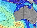 | 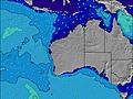 | 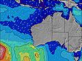 | 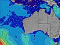 | ||||||||||||||
Wave Height (m) Direction Period (s) | SW 15 | SW 16 | SW 15 | WSW 18 | WSW 16 | WSW 16 | WSW 16 | WSW 16 | WSW 16 | WSW 16 | WSW 16 | WSW 16 | WSW 15 | WSW 15 | WSW 15 | SW 15 | SW 16 | SW 16 | SW 16 | SW 15 | SW 14 |
Wave Graph | |||||||||||||||||||||
1254 | 1532 | 1672 | 6996 | 6534 | 4883 | 10504 | 10787 | 9799 | 7775 | 6109 | 6829 | 6040 | 5052 | 11139 | 14258 | 16561 | 15026 | 10113 | 7870 | 5571 | |
Wind (km/h) | |||||||||||||||||||||
Wind State on-shore cross-onshore cross-shore cross-offshore off-shore glassy | cross | cross-on | cross-on | cross-on | cross-on | on | on | on | cross-on | cross-on | cross-on | on | on | cross-on | cross | cross | cross | cross | cross-on | cross-on | cross-on |
High Tide | 10:50AM0.49m | 1:49AM0.47m | 10:11AM0.40m | 2:24AM0.54m | 3:24AM0.60m | 4:37AM0.66m | 5:47AM0.72m | 6:48AM0.78m | |||||||||||||
Low Tide | 6:20PM0.26m | 7:31AM0.39m | 5:48PM0.28m | 3:22PM0.24m | 2:53PM0.14m | 3:14PM0.05m | 3:46PM-0.02m | 4:24PM-0.06m | |||||||||||||
7:11 | — | — | 7:09 | — | — | 7:09 | — | — | 7:07 | — | — | 7:07 | — | — | 7:05 | — | — | 7:05 | — | — | |
— | 5:40 | — | — | 5:42 | — | — | 5:43 | — | — | 5:43 | — | — | 5:44 | — | — | 5:45 | — | — | 5:45 | — | |
mm | — | — | 13 | — | — | — | 1 | 2 | 2 | — | — | 6 | 6 | 3 | 3 | — | — | — | 1 | — | 2 |
Temp °C | 16 | 18 | 16 | 14 | 15 | 16 | 16 | 16 | 17 | 17 | 17 | 17 | 16 | 15 | 15 | 13 | 13 | 14 | 15 | 15 | 16 |
Feels °C | 11 | 14 | 9 | 9 | 10 | 11 | 12 | 13 | 12 | 13 | 13 | 14 | 10 | 10 | 6 | 3 | 5 | 9 | 11 | 10 | 10 |
Swell 1 Height (m) Direction Period (s) | SW 15 | SW 16 | SW 15 | WSW 18 | WSW 16 | WSW 16 | WSW 16 | WSW 16 | WSW 16 | WSW 16 | WSW 16 | WSW 16 | WSW 15 | WSW 15 | — | — | SW 16 | SW 16 | SW 16 | SW 15 | SW 14 |
1254 | 1532 | 1672 | 6996 | 6534 | 4883 | 10504 | 10787 | 9799 | 7775 | 6109 | 6829 | 6040 | 5052 | — | — | 16561 | 15026 | 10113 | 7870 | 5571 | |
Swell 2 Height (m) Direction Period (s) | S 8 | — | WSW 20 | NW 6 | — | — | — | — | — | — | — | — | — | — | — | — | — | — | SW 21 | SW 21 | SW 20 |
51 | — | 1056 | 32 | — | — | — | — | — | — | — | — | — | — | — | — | — | — | 368 | 368 | 634 | |
Swell 3 Height (m) Direction Period (s) | — | — | — | — | — | — | — | — | — | — | — | — | — | — | — | — | — | — | — | — | — |
— | — | — | — | — | — | — | — | — | — | — | — | — | — | — | — | — | — | — | — | — | |
Wind waves Height (m) Direction Period (s) | N 4 | NNW 4 | W 6 | — | — | — | — | — | — | — | — | — | — | WSW 7 | WSW 15 | SW 15 | — | — | — | — | — |
30 | 29 | 190 | — | — | — | — | — | — | — | — | — | — | 484 | 11139 | 14258 | — | — | — | — | — | |
Nearest Offshore or Glassy | |||||||||||||||||||||
Distance (km) | 72 | 72 | 262 | 363 | 262 | 215 | 18 | 229 | 73 | 160 | 140 | 18 | 262 | 414 | 2008 | 1687 | 2567 | 16 | 18 | 363 | 363 |
Best forecast wave conditions in Margaret River | |||||||||||||||||||||
Best forecast wave conditions in Australia | |||||||||||||||||||||
Header Global | |||||||||||||||||||||
- Map Icons:
 Break
Break Live Wave Height (m)
 Live Wind Speed (km/h)
 Surf Rating (10 Max)
 Ocean Swells (m)
- Wind Speed (km/h)
Latest Updates


FREE! Surf-Forecast.com widget for your website
The surf report / weather widget below is available to embed on third party websites free of charge and provides a summary of our Injidup Carpark surf forecast. Simply grab the html code snippet that we provide and paste it into your own site. You can choose your preferred language and metric/imperial units for the surf forecast feed to suit users of your site. Click here to get the code.
Information about the Injidup Carpark Surf forecast
The above surf forecast table for Injidup Carpark provides essential information for determining whether the surfing conditions will be good over the next 16 days. A general guide to surfing at Injidup Carpark can be found by selecting the local surf guide option on the grey menu. Our Injidup Carpark surf forecast is unique since it includes wave energy (power) that defines the real feel of the surf rather than just the height or the period. If you surf the same spot (Injidup Carpark) regularly then make a mental note of the wave energy from the surf forecast table each time you go. Very soon you may start to choose your surf days based on the wave energy alone combined with our forecast of favourable offshore wind conditions. Our star ratings will help here and of course you will also find the usual wave height and period predictions on our surf forecasts as well as a full break down of the swell components under our advanced users option (to reveal that, click the little Einstein character under the tide times).
Further information to help with frequently asked questions about our surf forecast for Injidup Carpark may be found under the help tab on the top menu and also by moving your mouse over the question marks on the surf forecast table itself. Please always bear in mind that the forecast is for near-shore open water and local factors at each surf break influence the actual breaking wave height, such as the beach / reef profile, water depths offshore and shelter.
Injidup Carpark is 72 km (45 miles) from the city of Bunbury. If you plan a holiday in Margaret River, look for hotels and other accommodation in Bunbury. Bunbury has rooms for a wide range of budgets as well as car hire and transport links.
 Nearest