

Surf Forecasts:

Mount Cameron surf forecast from 2 Aug 2026:
- Best quality surf: Friday 7 Aug, 10AM (local time) - 8ft (2.5m), 16s period, WSW swell with glassy winds.
- Most powerful swell: Sunday 2 Aug, 1PM (local time) - 11ft (3.5m), 16s period, WSW swell with 5,218 kJ wave energy.
- Next surfable swell (1★+): Tuesday 4 Aug, 7AM (local time) - 11ft (3.5m), 12s period with WSW swell.
Best Forecast Surf Conditions for Mount Cameron this week:
The surf forecast for Mount Cameron over the next 16 days: The first swell (rated 1 star or higher) is forecast to arrive on Tuesday (Aug 04) at 7AM. The primary swell is predicted to be 3.5m and 12s period. The wind is predicted to be glassy as the swell arrives.
The most powerful waves expected at Mount Cameron in the next 16 days are 3.5m 16s and forecast to arrive on Sunday (Aug 02) at 1PM. Winds are predicted to be cross-offshore at the time the swell arrives. The largest open ocean swell (not directed at the beach) is 2.0m 6s period and expected on Sunday (Aug 09) at 1AM.
| Wave Type | Time (AEST) & Date | Wave Height & Period |
|---|---|---|
| Next good surf (1 star+) | 7AM (Tue 4th Aug) | 11ft (3.5m) 12s |
| Best Surf | 10AM (Fri 7th Aug) | 8ft (2.5m) 16s |
| Most Powerful | 1PM (Sun 2nd Aug) | 11ft (3.5m) 16s |
Table - best surf conditions forecast for Mount Cameron over the next 16 days.
The Lowdown
Alright, Rusty here. Let’s get into it.
Right off the bat, we’ve got some decent size rolling in, but the wind is the main character for most of this run. The only break on offer is Mount Cameron, a beach and reef setup that’s inconsistent. It’s exposed to the swell but needs the wind to play nice.
Water temp is sitting at about 56.5°F which is pretty normal for this time of year, nothin’ to write home about.
Sunday morning (August 2nd) kicks things off with a solid 11.5 ft from the WSW, period at 16 seconds – that’s a proper groundswell. The combined energy is strong at 5506. But here’s the catch: it’s a cross-offshore wind from the north at 12 mph. It’ll be clean enough for a confident surfer, but that size and the reef setup means this is not one for the groms. Afternoon drops a little to 9.8 ft, same wind, still alright.
Monday (August 3rd) sees a drop in size but the wind turns cross-on and gets messy. Morning is 6.6 ft with a cross-on from the west, choppy. Afternoon gets worse with onshore wind and rain. Skip it.
Tuesday (August 4th) is all cross-on winds too. A clean 9.8 ft in the morning is let down by the wind direction – still cross-onshore. It’ll be bumpy.
Wednesday (August 5th) is small and cross-on. Not worth paddling out.
Thursday (August 6th) stays small, cross-on winds, weak energy (1043). Not your day.
Now, Friday (August 7th) is the standout. Morning session is glassy – wind is basically nothing from the south at 3 mph. Swell is 8.2 ft from the WSW with a 16-second period, energy at 5087. That’s clean, powerful, and long-period. The afternoon stays glassy with 7.9 ft. For experienced surfers, this is as good as it gets in this forecast – the winds are perfect, the swell has punch. Mount Cameron will be lining up nicely. Crowds are possible here, so get in early.
Saturday (August 8th) morning is a proper offshore from the ENE at 16 mph, swell 8.2 ft from the WSW, 16-second period. That’s clean, hollow, and fast. Expert territory. Afternoon turns cross-off but still 8.2 ft – good, but a notch down.
Sunday (August 9th) drops to 6.9 ft with cross-off winds. Okay, but nothing special.
Monday (August 10th) gets huge – 14.8 ft from the WSW, 16-second period, but cross-on wind from the SSW at 12 mph making it choppy. Too big and messy for paddle surfing – might be a kite day.
Tuesday (August 11th) afternoon is worth a mention: 14.8 ft from the west, cross-shore wind, energy at 9417. Still big and a bit lumpy, but for the brave, there’ll be freight trains.
From Wednesday (August 12th) through the end of the outlook, it’s big swell but hammered by onshore and cross-on winds. 16.4 ft, 18.0 ft, all with onshore winds – dangerous and sloppy. Not for the average surfer.
Bottom line: The best window is Friday August 7th, with glassy conditions and solid 8.2 ft WSW groundswell. Saturday morning is also a winner with clean offshore winds. After that, the wind takes over and it’s a battle.
Stay safe out there.
Short Range ForecastModerate rain (total 13mm), heaviest on Sun night. Very mild (max 13°C on Sun night, min 9°C on Mon night). Wind will be generally light. | Days 4-6 Weather SummarySome drizzle, heaviest during Thu morning. Very mild (max 13°C on Thu morning, min 8°C on Fri night). Wind will be generally light. | ||||||||||||||||||||
Sunday 2 | Monday 3 | Tuesday 4 | Wednesday 5 | Thursday 6 | Friday 7 | Saturday 8 | |||||||||||||||
AM | PM | Night | AM | PM | Night | AM | PM | Night | AM | PM | Night | AM | PM | Night | AM | PM | Night | AM | PM | Night | |
Swell Height Map |  |  |  | 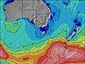 | 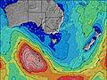 | 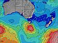 | 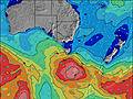 | ||||||||||||||
Wave Height (m) Direction Period (s) | WSW 16 | WSW 15 | WSW 15 | SW 14 | SW 14 | WSW 13 | WSW 12 | WSW 12 | WSW 11 | WSW 14 | WSW 13 | WSW 12 | WSW 12 | WSW 11 | SW 18 | WSW 16 | WSW 14 | WSW 16 | WSW 16 | SW 16 | WSW 15 |
Wave Graph | |||||||||||||||||||||
5506 | 4436 | 3783 | 1514 | 2004 | 1915 | 2502 | 1485 | 773 | 921 | 975 | 702 | 525 | 655 | 3219 | 2997 | 2317 | 3976 | 2948 | 3040 | 2111 | |
Wind (km/h) | |||||||||||||||||||||
Wind State on-shore cross-onshore cross-shore cross-offshore off-shore glassy | cross-off | cross-off | cross-off | cross-on | on | on | cross-on | cross-on | cross | cross-on | on | on | cross-on | on | cross | glassy | glassy | off | off | cross-off | cross-off |
High Tide | 2:47PM0.43m | 2:37AM0.31m | 3:00PM0.40m | 3:15AM0.33m | 3:07PM0.37m | 3:56AM0.35m | 3:07PM0.34m | 4:44AM0.35m | 2:52PM0.32m | 5:49AM0.35m | 2:12PM0.33m | 12:50PM0.36m | |||||||||
Low Tide | 9:11PM0.14m | 8:29AM0.10m | 9:21PM0.12m | 9:02AM0.14m | 9:32PM0.10m | 9:34AM0.19m | 9:46PM0.07m | 10:05AM0.24m | 10:02PM0.05m | 10:29AM0.30m | 10:24PM0.04m | 10:55PM0.03m | |||||||||
7:26 | — | — | 7:26 | — | — | 7:24 | — | — | 7:24 | — | — | 7:22 | — | — | 7:22 | — | — | 7:20 | — | — | |
— | 5:27 | — | — | 5:28 | — | — | 5:29 | — | — | 5:30 | — | — | 5:30 | — | — | 5:31 | — | — | 5:32 | — | |
mm | — | — | 7 | 4 | 2 | — | — | — | — | — | — | — | 1 | — | — | — | — | — | — | — | 6 |
Temp °C | 12 | 12 | 13 | 11 | 11 | 11 | 12 | 12 | 11 | 12 | 11 | 12 | 13 | 12 | 11 | 12 | 12 | 11 | 12 | 12 | 12 |
Feels °C | 7 | 7 | 8 | 7 | 6 | 7 | 8 | 9 | 9 | 9 | 7 | 8 | 10 | 9 | 9 | 10 | 10 | 8 | 7 | 6 | 5 |
Swell 1 Height (m) Direction Period (s) | WSW 16 | WSW 15 | WSW 15 | SW 14 | SW 14 | WSW 13 | WSW 12 | WSW 12 | WSW 11 | WSW 14 | WSW 13 | WSW 12 | WSW 12 | WSW 11 | SW 18 | WSW 16 | WSW 14 | WSW 16 | WSW 16 | SW 16 | WSW 15 |
5506 | 4436 | 3783 | 1514 | 2004 | 1915 | 2502 | 1485 | 773 | 921 | 975 | 702 | 525 | 655 | 3219 | 2997 | 2317 | 3976 | 2948 | 3040 | 2111 | |
Swell 2 Height (m) Direction Period (s) | — | — | WSW 20 | WSW 16 | — | SW 18 | SW 16 | SW 15 | SW 20 | SW 19 | SW 18 | SW 17 | SW 16 | SW 15 | W 9 | WSW 19 | SW 18 | — | — | — | WNW 8 |
— | — | 216 | 779 | — | 255 | 427 | 318 | 483 | 817 | 552 | 470 | 416 | 435 | 246 | 1981 | 1839 | — | — | — | 131 | |
Swell 3 Height (m) Direction Period (s) | — | — | — | — | — | — | — | SW 21 | — | S 9 | — | S 8 | SW 20 | SW 20 | — | W 8 | — | — | — | — | — |
— | — | — | — | — | — | — | 115 | — | 15 | — | 34 | 102 | 552 | — | 109 | — | — | — | — | — | |
Wind waves Height (m) Direction Period (s) | — | N 6 | N 6 | WNW 10 | WNW 9 | WNW 9 | — | — | SSW 7 | SSW 7 | SSW 9 | — | — | — | — | — | — | — | NNE 4 | N 5 | N 6 |
— | 39 | 86 | 869 | 495 | 237 | — | — | 180 | 71 | 82 | — | — | — | — | — | — | — | 12 | 55 | 311 | |
Nearest Offshore or Glassy | |||||||||||||||||||||
Distance (km) | 242 | 244 | 242 | 125 | 121 | 248 | 10 | 125 | 10 | 125 | 125 | 248 | 248 | 248 | 10 | 0 | 0 | 0 | 0 | 244 | 242 |
Best forecast wave conditions in West Coast of Tasmania | |||||||||||||||||||||
Best forecast wave conditions in Australia | |||||||||||||||||||||
Header Global | |||||||||||||||||||||
- Map Icons:
 Break
Break Live Wave Height (m)
 Live Wind Speed (km/h)
 Surf Rating (10 Max)
 Ocean Swells (m)
- Wind Speed (km/h)
Latest Updates


FREE! Surf-Forecast.com widget for your website
The surf report / weather widget below is available to embed on third party websites free of charge and provides a summary of our Mount Cameron surf forecast. Simply grab the html code snippet that we provide and paste it into your own site. You can choose your preferred language and metric/imperial units for the surf forecast feed to suit users of your site. Click here to get the code.
Information about the Mount Cameron Surf forecast
The above surf forecast table for Mount Cameron provides essential information for determining whether the surfing conditions will be good over the next 16 days. A general guide to surfing at Mount Cameron can be found by selecting the local surf guide option on the grey menu. Our Mount Cameron surf forecast is unique since it includes wave energy (power) that defines the real feel of the surf rather than just the height or the period. If you surf the same spot (Mount Cameron) regularly then make a mental note of the wave energy from the surf forecast table each time you go. Very soon you may start to choose your surf days based on the wave energy alone combined with our forecast of favourable offshore wind conditions. Our star ratings will help here and of course you will also find the usual wave height and period predictions on our surf forecasts as well as a full break down of the swell components under our advanced users option (to reveal that, click the little Einstein character under the tide times).
Further information to help with frequently asked questions about our surf forecast for Mount Cameron may be found under the help tab on the top menu and also by moving your mouse over the question marks on the surf forecast table itself. Please always bear in mind that the forecast is for near-shore open water and local factors at each surf break influence the actual breaking wave height, such as the beach / reef profile, water depths offshore and shelter.
Are you planning a holiday in West Coast of Tasmania? If you are looking for accommodation near Mount Cameron, camping, hotels and holiday cottages in West Coast of Tasmania, consider staying in Stanley which is 51 km (32 miles) away. Alternatively, find information about places to stay and car hire in Port Latta which is 57 km (35 miles) away
 Nearest