

Surf Forecasts:

Apollo Bay surf forecast from 3 Aug 2026:
- Best quality surf: Monday 10 Aug, 7AM (local time) - 15ft (4.5m), 12s period, WSW swell with offshore winds.
- Most powerful swell: Monday 10 Aug, 7PM (local time) - 11ft (3.5m), 17s period, SW swell with 7,000 kJ wave energy.
- Next surfable swell (1★+): Tuesday 4 Aug, 1AM (local time) - 11ft (3.5m), 13s period with WSW swell.
Best Forecast Surf Conditions for Apollo Bay this week:
The surf forecast for Apollo Bay over the next 16 days: The first swell (rated 1 star or higher) is forecast to arrive on Tuesday (Aug 04) at 1AM. The primary swell is predicted to be 3.5m and 13s period with a secondary swell of 1.6m and 12s. Another secondary swell of 0.6m and 18s is also forecast. The wind is predicted to be offshore as the swell arrives.
The most powerful waves expected at Apollo Bay in the next 16 days are 3.5m 17s and forecast to arrive on Monday (Aug 10) at 7PM. Winds are predicted to be cross-onshore at the time the swell arrives. The largest open ocean swell (not directed at the beach) is 1.2m 6s period and expected on Thursday (Aug 06) at 4PM.
| Wave Type | Time (AEST) & Date | Wave Height & Period |
|---|---|---|
| Next good surf (1 star+) | 1AM (Tue 4th Aug) | 11ft (3.5m) 13s |
| Best Surf | 7AM (Mon 10th Aug) | 15ft (4.5m) 12s |
| Most Powerful | 7PM (Mon 10th Aug) | 11ft (3.5m) 17s |
Table - best surf conditions forecast for Apollo Bay over the next 16 days.
The Lowdown
G’day, Rusty here. Let’s have a look at what’s cookin’ for Apollo Bay.
Alright, this stretch is lookin’ at a pretty wild ride over the next couple of weeks. We kick things off with some serious size and energy, and it just keeps building into a monster pulse later on. Early on though, we’ve got to work for it with some onshore wind, but the quality picks up as we go.
The water at Apollo Bay is sittin’ at about 58°, which is pretty bang on average for this time of year. No surprises there.
Monday 3rd – Tuesday 4th August: We’re straight into it Monday arvo with a solid 7ft WSW groundswell, but it’s a bit bumpy with a fresh 19 mph westerly. The wave energy is pumpin’ (2452), so there’s power, but it’s not the cleanest. Tuesday morning bumps up to a chunky 12ft from the WSW, and the cross-off breeze helps a bit. Still a bit raw, though. The swell’s got a 12-second period, so there’s some proper length between sets. This is expert territory at that size – 12ft is too big for beginners.
Wednesday 5th August: This is where the first real standout lies. Wednesday arvo the wind switches to a clean offshore from the WSW at 12 mph. The swell is 7ft from the SW with a 14-second period – that’s proper groundswell energy (2277). This is the best on offer in the first week. Apollo Bay is a beach and point setup, and that long-period groundswell loves a point, so shape should be excellent. Moderate offshore and clean – this is the one to circle on the calendar.
Thursday 6th – Friday 7th August: Thursday drops right off to tiny 2ft – not worth paddling for. Friday brings a little pulse back: 5ft SW groundswell with a 16-second period (992 energy). Not huge, but Friday arvo we get glassy conditions – dead calm with a 3 mph northerly. That’s gold. Nice clean lines for the patient surfer, but you’ll be waiting for sets.
Saturday 8th – Sunday 9th August: Saturday is a write-off. Cross-shore wind and messy conditions. Sunday arvo gets a strong 25 mph offshore from the W, whipping the 5ft swell into shape, but honestly, it’s gonna be hard to paddle into. More for the tow crew.
Monday 10th August – The Big Push: Here we go. Monday morning brings a thumping 10ft SW swell with a 16-second period and a gentle offshore breeze. By the arvo it’s 12ft from the SW, light wind, and the energy is through the roof at 6075. This is big, powerful, and clean – but only for experts. If you’ve got the balls, this is a standout.
Tuesday 11th – Wednesday 12th August: Tuesday gets cross-shore and messy again on the 8ft swell. Not ideal. Wednesday, though, we get a massive 12ft SW swell with an 18-second period – that’s a very long period groundswell, energy reading 7786. The wind is cross-off and fresh, so it’ll be clean, but that period is so long it might want to race down the beach. At Apollo Bay, the point there should really hold that.
Thursday 13th – Friday 16th August: Thursday stays chunky and clean-ish. Friday 14th is where things go a bit nuts – we’ve got 21ft of SW swell rollin’ in (24541 energy). That is massive. Way too big for this break. Only for the absolute elite or the crazies. Saturday and Sunday stay well overhead, 13-16ft, with decent winds. This whole run is expert-only, size-wise.
Monday 17th – Tuesday 18th August: Finally, we get a drop-off. Monday still has a solid 13ft SW groundswell but with a gentle offshore breeze – still heavy, but the arvo drops to 10ft. By Tuesday we’re down to 4ft with a 16-second period and gentle offshore wind. A nice, mellow end to a wild period.
The Pick of the Fortnight: Without a doubt, Wednesday 5th August afternoon is your first standout – 7ft SW, offshore wind, clean. The second standout is the Monday 10th August session with 12ft, light wind, but that’s for experts only. The long-range pulse on Wednesday 12th August (12ft SW, 18-second period, cross-off) is also a big call, but that’s more in the realms of “watch the forecast, hope the wind holds.” The point break at Apollo Bay should handle that long-period energy well, but it’s going to be big and powerful.
Keep in mind that the 14th and 15th of August are just plain massive – over 16ft. Too big for a standard paddle.
That’s it from me. Stay safe out there.
Rusty
Short Range ForecastHeavy rain (total 20mm), heaviest during Mon night. Very mild (max 12°C on Wed morning, min 8°C on Wed night). Winds decreasing (fresh winds from the W on Mon afternoon, light winds from the NW by Wed night). | Days 5-7 Weather SummaryModerate rain (total 17mm), heaviest on Sat night. Very mild (max 16°C on Sat morning, min 7°C on Thu night). Winds increasing (calm on Fri afternoon, strong winds from the W by Sun morning). | |||||||||||||||||||
Mon 3 | Tuesday 4 | Wednesday 5 | Thursday 6 | Friday 7 | Saturday 8 | Sunday 9 | ||||||||||||||
PM | Night | AM | PM | Night | AM | PM | Night | AM | PM | Night | AM | PM | Night | AM | PM | Night | AM | PM | Night | |
Swell Height Map |  |  |  | 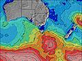 | 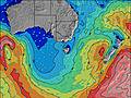 | 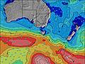 | 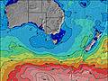 | |||||||||||||
Wave Height (m) Direction Period (s) | WSW 13 | WSW 13 | WSW 12 | SW 11 | SW 9 | SW 14 | SW 14 | SW 17 | SW 16 | SW 16 | SW 18 | SW 16 | SW 15 | SW 17 | SW 16 | SW 16 | SW 15 | WSW 15 | SW 15 | SW 19 |
Wave Graph | ||||||||||||||||||||
1520 | 4156 | 3488 | 1428 | 560 | 1238 | 1688 | 290 | 248 | 291 | 370 | 906 | 649 | 962 | 1123 | 989 | 543 | 711 | 1088 | 2861 | |
Wind (km/h) | ||||||||||||||||||||
Wind State on-shore cross-onshore cross-shore cross-offshore off-shore glassy | off | off | cross-off | cross-off | cross-off | cross-off | off | cross-off | cross-off | cross-off | off | cross-off | glassy | cross | cross | cross | cross | cross-off | off | off |
High Tide | 3:40AM2.10m | 4:19PM2.00m | 4:03AM2.02m | 5:00PM2.02m | 4:27AM1.93m | 5:46PM2.00m | 4:53AM1.85m | 6:41PM1.95m | 5:22AM1.77m | 7:49PM1.89m | 5:59AM1.68m | 9:15PM1.87m | ||||||||
Low Tide | 9:35PM0.60m | 10:01AM0.36m | 10:10PM0.69m | 10:29AM0.25m | 10:47PM0.82m | 11:00AM0.18m | 11:25PM0.97m | 11:37AM0.15m | 00:09AM1.14m | 12:20PM0.18m | 1:06AM1.29m | 1:16PM0.26m | 2:53AM1.40m | |||||||
— | — | 7:24 | — | — | 7:24 | — | — | 7:22 | — | — | 7:22 | — | — | 7:20 | — | — | 7:18 | — | — | |
5:37 | — | — | 5:37 | — | — | 5:37 | — | — | 5:38 | — | — | 5:39 | — | — | 5:40 | — | — | 5:42 | — | |
mm | 1 | 4 | 4 | 3 | 6 | 1 | — | — | 1 | 1 | — | — | — | — | — | — | 13 | 3 | 1 | 8 |
Temp °C | 11 | 10 | 11 | 11 | 11 | 12 | 12 | 10 | 11 | 12 | 9 | 13 | 13 | 12 | 16 | 14 | 11 | 11 | 10 | 10 |
Feels °C | 4 | 4 | 6 | 6 | 7 | 7 | 7 | 7 | 6 | 7 | 6 | 10 | 11 | 10 | 11 | 8 | 5 | 5 | 1 | 1 |
Swell 1 Height (m) Direction Period (s) | SW 13 | SW 12 | SW 12 | SW 11 | SW 10 | SSW 8 | SSW 7 | SW 17 | SW 16 | SW 16 | SW 18 | SW 16 | SW 15 | SW 17 | SW 16 | SW 16 | SW 15 | WSW 15 | SW 15 | SW 19 |
560 | 724 | 800 | 741 | 269 | 165 | 86 | 290 | 248 | 291 | 370 | 906 | 649 | 962 | 1123 | 989 | 543 | 711 | 1088 | 2861 | |
Swell 2 Height (m) Direction Period (s) | WSW 15 | SW 18 | SW 16 | SW 15 | SW 12 | SW 15 | SW 14 | SSW 7 | SSW 8 | S 8 | SW 15 | SSW 6 | SW 19 | S 6 | — | — | SW 18 | NE 6 | — | — |
372 | 192 | 161 | 149 | 141 | 209 | 293 | 47 | 37 | 12 | 255 | 27 | 299 | 19 | — | — | 83 | 8 | — | — | |
Swell 3 Height (m) Direction Period (s) | — | SW 13 | — | — | SW 21 | SW 19 | SW 18 | SW 12 | SW 11 | W 6 | S 5 | SW 19 | S 6 | — | — | — | WSW 18 | — | — | — |
— | 44 | — | — | 150 | 234 | 210 | 92 | 33 | 6 | 13 | 59 | 29 | — | — | — | 497 | — | — | — | |
Wind waves Height (m) Direction Period (s) | WSW 13 | WSW 13 | WSW 12 | SW 11 | SW 9 | SW 14 | SW 14 | — | WSW 5 | W 6 | WSW 7 | — | — | — | — | ENE 7 | NNE 5 | NW 3 | WNW 3 | NW 3 |
1520 | 4156 | 3488 | 1428 | 560 | 1238 | 1688 | — | 36 | 102 | 229 | — | — | — | — | 18 | 39 | 6 | 4 | 8 | |
Nearest Offshore or Glassy | ||||||||||||||||||||
Distance (km) | 35 | 0 | 35 | 57 | 33 | 33 | 0 | 0 | 19 | 74 | 0 | 0 | 0 | 18 | 18 | 39 | 213 | 567 | 567 | 535 |
Best forecast wave conditions in Cape Otway | ||||||||||||||||||||
Best forecast wave conditions in Australia | ||||||||||||||||||||
Header Global | ||||||||||||||||||||
- Map Icons:
 Break
Break Live Wave Height (m)
 Live Wind Speed (km/h)
 Surf Rating (10 Max)
 Ocean Swells (m)
- Wind Speed (km/h)
Latest Updates


FREE! Surf-Forecast.com widget for your website
The surf report / weather widget below is available to embed on third party websites free of charge and provides a summary of our Apollo Bay surf forecast. Simply grab the html code snippet that we provide and paste it into your own site. You can choose your preferred language and metric/imperial units for the surf forecast feed to suit users of your site. Click here to get the code.
Information about the Apollo Bay Surf forecast
The above surf forecast table for Apollo Bay provides essential information for determining whether the surfing conditions will be good over the next 16 days. A general guide to surfing at Apollo Bay can be found by selecting the local surf guide option on the grey menu. Our Apollo Bay surf forecast is unique since it includes wave energy (power) that defines the real feel of the surf rather than just the height or the period. If you surf the same spot (Apollo Bay) regularly then make a mental note of the wave energy from the surf forecast table each time you go. Very soon you may start to choose your surf days based on the wave energy alone combined with our forecast of favourable offshore wind conditions. Our star ratings will help here and of course you will also find the usual wave height and period predictions on our surf forecasts as well as a full break down of the swell components under our advanced users option (to reveal that, click the little Einstein character under the tide times).
Further information to help with frequently asked questions about our surf forecast for Apollo Bay may be found under the help tab on the top menu and also by moving your mouse over the question marks on the surf forecast table itself. Please always bear in mind that the forecast is for near-shore open water and local factors at each surf break influence the actual breaking wave height, such as the beach / reef profile, water depths offshore and shelter.
Apollo Bay is 91 km (57 miles) from the city of Geelong West. If you plan a holiday in Cape Otway, look for hotels and other accommodation in Geelong West. Geelong West has rooms for a wide range of budgets as well as car hire and transport links.
 Nearest