
Surf Forecasts:

Etang-Sale surf forecast from 2 Aug 2026:
- Best quality surf: Monday 3 Aug, 4AM (local time) - 4.5ft (1.4m), 14s period, SW swell with glassy winds.
- Most powerful swell: Saturday 8 Aug, 4AM (local time) - 4.5ft (1.3m), 19s period, SSW swell with 1,111 kJ wave energy.
- Next surfable swell (1★+): Monday 3 Aug, 4AM (local time) - 4.5ft (1.4m), 14s period with SW swell.
Best Forecast Surf Conditions for Etang-Sale this week:
The surf forecast for Etang-Sale over the next 16 days: The first swell (rated 1 star or higher) is forecast to arrive on Monday (Aug 03) at 4AM. The primary swell is predicted to be 1.4m and 14s period with a secondary swell of 1.0m and 9s. The wind is predicted to be glassy as the swell arrives.
The most powerful waves expected at Etang-Sale in the next 16 days are 1.3m 19s and forecast to arrive on Saturday (Aug 08) at 4AM. Winds are predicted to be cross-offshore at the time the swell arrives. The largest open ocean swell (not directed at the beach) is 2.5m 9s period and expected on Wednesday (Aug 05) at 7PM.
| Wave Type | Time (+04) & Date | Wave Height & Period |
|---|---|---|
| Next good surf (1 star+) | 4AM (Mon 3rd Aug) | 4.5ft (1.4m) 14s |
| Best Surf | 4AM (Mon 3rd Aug) | 4.5ft (1.4m) 14s |
| Most Powerful | 4AM (Sat 8th Aug) | 4.5ft (1.3m) 19s |
Table - best surf conditions forecast for Etang-Sale over the next 16 days.
The Lowdown
Hey, it’s Rusty. Let’s break down what’s cooking at Etang-Sale.
The surf kicks off now on Monday morning, and the water temp is about average for the season. The real standout is the morning of Friday, August 7th – a clean 8ft swell from the ESE with a gentle offshore breeze from the SE. The wave energy is cranking at 1201, so there’s plenty of punch. At an advanced reef like this, that’s the session to aim for.
Monday morning the 3rd is glassy with a 4ft SW swell and a 14-second period – real quality. Combined energy is 1333, strong. The afternoon gets cross-on wind, so go early.
Tuesday the 4th is clean with small 2ft south swell, glassy in the afternoon. Wednesday the 5th is a skip with rain and onshore wind. Thursday the 6th afternoon comes back with a glassy 5ft ESE swell, but short period of 9 seconds.
Friday the 7th morning is the top pick. Saturday the 8th morning has a 4ft SSW swell with a long 18-second period and clean offshore wind, energy at 2017. Sunday the 9th morning is similar, 4ft SW swell, 15-second period, clean. Sunday afternoon jumps to 8ft ESE but with a short 8-second period and rain.
The next week, Monday the 10th through Thursday the 13th, every morning offers clean offshore winds with swells from 4ft to 6ft and periods of 13 to 16 seconds. Energy is moderate to strong, like 1081 on Monday morning.
Saturday the 15th morning has a 3ft SSW swell with a very long 19-second period – that’s groundswell, great for the reef. The afternoon gets a stiff 25 mph offshore wind, making it tough to paddle into.
The second week’s big moment is Tuesday morning, August 18th – a massive 12ft SSW swell with a 15-second period and combined energy of 6636. That’s expert territory only. The wind is offshore and clean, but at that size, it’s not for the faint-hearted.
Crowds can show up, but with this quality, it’s worth it. Etang-Sale is the only spot, and it’s delivering over and over.
Rusty.
Short Range ForecastLight rain (total 3mm), mostly falling on Sun night. Warm (max 24°C on Mon morning, min 23°C on Sun night). Wind will be generally light. | Days 5-7 Weather SummaryLight rain (total 3mm), mostly falling on Wed night. Warm (max 24°C on Fri morning, min 22°C on Wed night). Winds increasing (calm on Wed night, fresh winds from the SE by Sat afternoon). | ||||||||||||||||||
Monday 3 | Tuesday 4 | Wednesday 5 | Thursday 6 | Friday 7 | Saturday 8 | ||||||||||||||
Night | AM | PM | Night | AM | PM | Night | AM | PM | Night | AM | PM | Night | AM | PM | Night | AM | PM | Night | |
Swell Height Map |  | 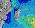 | 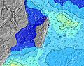 | 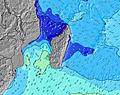 | 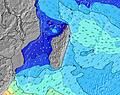 | 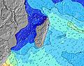 | 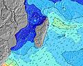 | ||||||||||||
Wave Height (m) Direction Period (s) | SW 14 | SW 14 | SW 13 | S 15 | SW 13 | S 13 | SSW 16 | SSW 15 | SSW 15 | ESE 9 | SW 13 | ESE 9 | ESE 9 | ESE 9 | SSW 22 | SSW 20 | SSW 18 | SW 16 | SW 15 |
Wave Graph | |||||||||||||||||||
810 | 696 | 444 | 246 | 171 | 166 | 171 | 287 | 382 | 773 | 261 | 442 | 660 | 791 | 423 | 942 | 1044 | 952 | 753 | |
Wind (km/h) | |||||||||||||||||||
Wind State on-shore cross-onshore cross-shore cross-offshore off-shore glassy | glassy | glassy | cross-on | glassy | cross-off | glassy | cross-on | cross-on | on | glassy | cross-on | glassy | off | off | glassy | cross-off | off | off | cross-off |
High Tide | 2:43AM0.54m | 3:22PM0.52m | 3:19AM0.50m | 3:57PM0.50m | 4:02AM0.44m | 4:40PM0.47m | 5:09AM0.38m | 5:48PM0.44m | 8:01AM0.34m | 7:53PM0.42m | 10:37AM0.38m | 9:43PM0.45m | |||||||
Low Tide | 9:03AM0.10m | 9:22PM0.18m | 9:32AM0.14m | 10:07PM0.20m | 10:07AM0.19m | 11:15PM0.22m | 10:55AM0.25m | 1:28AM0.22m | 1:16PM0.29m | 3:37AM0.17m | 3:43PM0.28m | ||||||||
— | 6:48 | — | — | 6:48 | — | — | 6:48 | — | — | 6:48 | — | — | 6:47 | — | — | 6:46 | — | — | |
— | — | 6:00 | — | — | 6:00 | — | — | 6:00 | — | — | 6:00 | — | — | 6:00 | — | — | 6:01 | — | |
mm | 1 | — | — | — | — | — | — | 1 | 1 | 1 | — | — | 1 | — | — | 1 | — | — | — |
Temp °C | 23 | 24 | 24 | 23 | 24 | 24 | 23 | 24 | 24 | 23 | 23 | 23 | 23 | 24 | 23 | 23 | 24 | 24 | 22 |
Feels °C | 25 | 27 | 25 | 25 | 25 | 26 | 25 | 25 | 25 | 25 | 23 | 25 | 24 | 24 | 24 | 24 | 20 | 19 | 20 |
Swell 1 Height (m) Direction Period (s) | SW 14 | SW 14 | SW 13 | SW 13 | SW 13 | S 13 | SE 10 | SSW 15 | SSW 15 | SW 14 | SW 13 | SSW 13 | SW 13 | SE 8 | SSW 12 | SSW 20 | SSW 18 | SW 16 | SW 15 |
810 | 696 | 444 | 246 | 161 | 166 | 110 | 287 | 382 | 384 | 261 | 299 | 241 | 126 | 190 | 942 | 1044 | 952 | 753 | |
Swell 2 Height (m) Direction Period (s) | SE 9 | ESE 9 | SE 9 | SE 8 | SE 9 | SW 12 | S 12 | SE 9 | S 11 | SE 8 | SE 8 | SE 8 | SE 8 | SW 12 | SSW 22 | SE 6 | SE 8 | SW 11 | SE 6 |
141 | 145 | 118 | 84 | 79 | 93 | 144 | 97 | 60 | 118 | 78 | 66 | 88 | 175 | 423 | 64 | 101 | 42 | 56 | |
Swell 3 Height (m) Direction Period (s) | S 19 | S 18 | S 16 | S 15 | S 13 | SSE 9 | SSW 16 | S 12 | S 17 | S 11 | S 11 | S 16 | S 16 | S 15 | ESE 8 | SW 12 | SW 12 | S 11 | SW 20 |
587 | 492 | 257 | 209 | 171 | 17 | 171 | 69 | 6 | 21 | 9 | 5 | 47 | 109 | 24 | 118 | 114 | 21 | 98 | |
Wind waves Height (m) Direction Period (s) | — | — | — | ESE 9 | — | SE 9 | E 9 | — | SE 9 | ESE 9 | E 9 | ESE 9 | ESE 9 | ESE 9 | SE 6 | E 9 | ESE 9 | SE 6 | ESE 9 |
— | — | — | 540 | — | 93 | 721 | — | 122 | 773 | 544 | 442 | 660 | 791 | 75 | 661 | 758 | 101 | 471 | |
Nearest Offshore or Glassy | |||||||||||||||||||
Distance (km) | 0 | 0 | 14 | 0 | 0 | 0 | 14 | 26 | 14 | 0 | 14 | 0 | 0 | 0 | 0 | 0 | 0 | 13 | 0 |
Best forecast wave conditions in Réunion Island | |||||||||||||||||||
Best forecast wave conditions in Reunion | |||||||||||||||||||
Header Global | |||||||||||||||||||
- Map Icons:
 Break
Break Live Wave Height (m)
 Live Wind Speed (km/h)
 Surf Rating (10 Max)
 Ocean Swells (m)
- Wind Speed (km/h)
Latest Updates


FREE! Surf-Forecast.com widget for your website
The surf report / weather widget below is available to embed on third party websites free of charge and provides a summary of our Etang-Sale surf forecast. Simply grab the html code snippet that we provide and paste it into your own site. You can choose your preferred language and metric/imperial units for the surf forecast feed to suit users of your site. Click here to get the code.
Information about the Etang-Sale Surf forecast
The above surf forecast table for Etang-Sale provides essential information for determining whether the surfing conditions will be good over the next 16 days. A general guide to surfing at Etang-Sale can be found by selecting the local surf guide option on the grey menu. Our Etang-Sale surf forecast is unique since it includes wave energy (power) that defines the real feel of the surf rather than just the height or the period. If you surf the same spot (Etang-Sale) regularly then make a mental note of the wave energy from the surf forecast table each time you go. Very soon you may start to choose your surf days based on the wave energy alone combined with our forecast of favourable offshore wind conditions. Our star ratings will help here and of course you will also find the usual wave height and period predictions on our surf forecasts as well as a full break down of the swell components under our advanced users option (to reveal that, click the little Einstein character under the tide times).
Further information to help with frequently asked questions about our surf forecast for Etang-Sale may be found under the help tab on the top menu and also by moving your mouse over the question marks on the surf forecast table itself. Please always bear in mind that the forecast is for near-shore open water and local factors at each surf break influence the actual breaking wave height, such as the beach / reef profile, water depths offshore and shelter.
Etang-Sale is 8 km (5 miles) from Saint-Louis. If you plan a holiday in Réunion Island, look for hotels and other accommodation in Saint-Louis. Saint-Louis has rooms for a wide range of budgets as well as car hire and transport links.
 Nearest