

Surf Forecasts:

Bullies surf forecast from 3 Jul 2026:
- Best quality surf: Monday 6 Jul, 12AM (local time) - 8ft (2.5m), 16s period, SSW swell with cross-offshore winds.
- Most powerful swell: Sunday 5 Jul, 6AM (local time) - 11ft (3.5m), 17s period, SSW swell with 7,019 kJ wave energy.
- Next surfable swell (1★+): Monday 6 Jul, 12AM (local time) - 8ft (2.5m), 16s period with SSW swell.
Best Forecast Surf Conditions for Bullies this week:
The surf forecast for Bullies over the next 16 days: The first swell (rated 1 star or higher) is forecast to arrive on Monday (Jul 06) at 12AM. The primary swell is predicted to be 2.5m and 16s period. The wind is predicted to be cross-offshore as the swell arrives.
The most powerful waves expected at Bullies in the next 16 days are 3.5m 17s and forecast to arrive on Sunday (Jul 05) at 6AM. Winds are predicted to be cross-onshore at the time the swell arrives. The largest open ocean swell (not directed at the beach) is 1.2m 16s period and expected on Thursday (Jul 09) at 9PM.
| Wave Type | Time (ACST) & Date | Wave Height & Period |
|---|---|---|
| Next good surf (1 star+) | 12AM (Mon 6th Jul) | 8ft (2.5m) 16s |
| Best Surf | 12AM (Mon 6th Jul) | 8ft (2.5m) 16s |
| Most Powerful | 6AM (Sun 5th Jul) | 11ft (3.5m) 17s |
Table - best surf conditions forecast for Bullies over the next 16 days.
Updates in hr min s Forecast update imminent
Alright, Rusty here again.
We’ve got a solid run of surf coming up over the next couple of weeks at Bullies, but you’ve got to pick your moments. The first few days are a bit messy with some lumpy cross-shore winds and questionable conditions, but there’s some quality windows later on that are well worth getting excited about. The water temp is sitting at 59°F, which is about normal for this time of year – nothing unusual there.
The first real standout is shaping up for Monday, July 6th morning. Bullies will have a clean 7ft SSW swell with a long 14-second period, and the wind is a light cross-offshore from the NE. That’s a beautiful combo – the wave energy is moderate (1592), but the conditions will be clean and well-shaped for experienced surfers. This is the kind of morning where you paddle out early and don’t regret it.
Then, Wednesday, July 8th morning is the true highlight. Swell is 8ft from the SSW with a very long 18-second period, cross-offshore NE wind at just 6 mph, and the combined energy is strong (3413). This is a serious groundswell – the kind that will set up lovely lines at Bullies, though with that long period it might get a bit straight at the beach. Still, for advanced surfers, this is the best on offer. Keep in mind, with the size over 8ft, it’s strictly for the experienced crew.
There’s a bit of a lull mid-month. From Tuesday, July 14th through to Wednesday, July 15th afternoon, it’s pretty poor – cross-onshore winds, lumpy, choppy, and the swell drops off. Not worth paddling out unless you enjoy a beating.
Things clean up again on Saturday, July 18th morning with a 5ft SSW swell, light offshore NNW wind, and clean conditions. It’s not big, but it’ll be fun and clean – a good way to close out the forecast window.
Crowds? Bullies can get busy sometimes, so if you’re heading out on the Monday or Wednesday standouts, get there early.
One more thing: there’s a gap of about two days in the middle where there’s really nothing worth riding. But overall, the consistent swells and clean windows make this a promising stretch.
Rusty.
Short Range ForecastMostly dry. Very mild (max 14°C on Sat morning, min 7°C on Sun night). Wind will be generally light. | Days 5-7 Weather SummaryMostly dry. Very mild (max 13°C on Tue afternoon, min 9°C on Wed morning). Wind will be generally light. | ||||||||||||||||||||
Saturday 4 | Sunday 5 | Monday 6 | Tuesday 7 | Wednesday 8 | Thursday 9 | Fri 10 | |||||||||||||||
Night | AM | PM | Night | AM | PM | Night | AM | PM | Night | AM | PM | Night | AM | PM | Night | AM | PM | Night | AM | PM | |
Swell Height Map | 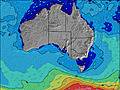 | 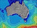 | 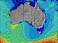 | 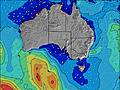 | 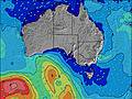 | 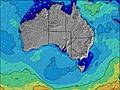 | 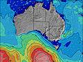 | 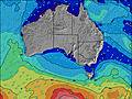 | |||||||||||||
Wave Height (m) Direction Period (s) | SSW 13 | SSW 13 | SSW 13 | SSW 15 | SSW 17 | SSW 16 | SSW 16 | SSW 14 | SSW 14 | SSW 13 | SSW 16 | SSW 16 | SSW 15 | SSW 18 | SSW 17 | SSW 16 | SSW 15 | SSW 15 | SSW 16 | SSW 14 | SSW 14 |
Wave Graph | |||||||||||||||||||||
3355 | 2117 | 1811 | 3574 | 7019 | 5083 | 3288 | 1748 | 1080 | 623 | 1055 | 1067 | 1178 | 3491 | 3102 | 1834 | 1117 | 1024 | 1225 | 785 | 626 | |
Wind (km/h) | |||||||||||||||||||||
Wind State on-shore cross-onshore cross-shore cross-offshore off-shore glassy | cross | cross-on | on | cross-on | cross | cross-on | cross-off | cross-off | cross | cross-off | cross-off | cross | cross-off | cross-off | cross | cross-off | cross-off | cross-on | cross-off | cross-off | off |
High Tide | 2:31AM0.65m | 3:04PM1.25m | 3:05AM0.70m | 3:30PM1.18m | 3:43AM0.76m | 3:52PM1.11m | 4:27AM0.84m | 4:09PM1.03m | 5:19AM0.91m | 4:10PM0.95m | 6:42AM0.98m | 11:09AM1.17m | |||||||||
Low Tide | 10:17PM0.48m | 7:11AM0.35m | 10:31PM0.49m | 7:46AM0.41m | 10:47PM0.52m | 8:19AM0.52m | 11:03PM0.55m | 8:48AM0.66m | 11:17PM0.58m | 8:55AM0.82m | 11:26PM0.60m | 7:57AM0.97m | 10:31PM0.60m | ||||||||
— | 7:24 | — | — | 7:24 | — | — | 7:24 | — | — | 7:24 | — | — | 7:24 | — | — | 7:24 | — | — | 7:24 | — | |
— | — | 5:14 | — | — | 5:14 | — | — | 5:15 | — | — | 5:15 | — | — | 5:15 | — | — | 5:15 | — | — | 5:16 | |
mm | — | — | — | — | — | — | — | — | — | — | — | — | — | — | — | — | — | — | — | — | — |
Temp °C | 13 | 14 | 13 | 13 | 10 | 11 | 11 | 11 | 13 | 12 | 12 | 13 | 12 | 12 | 12 | 11 | 11 | 11 | 10 | 13 | 14 |
Feels °C | 11 | 11 | 10 | 10 | 6 | 8 | 8 | 8 | 10 | 10 | 8 | 10 | 10 | 10 | 9 | 10 | 8 | 8 | 8 | 10 | 11 |
Swell 1 Height (m) Direction Period (s) | SSW 13 | SSW 13 | SSW 13 | SSW 15 | SSW 17 | SSW 16 | SSW 16 | SSW 14 | SSW 14 | SSW 13 | SSW 16 | SSW 16 | SSW 15 | SSW 18 | SSW 17 | SSW 16 | SSW 15 | SSW 15 | SSW 16 | SSW 14 | SSW 14 |
3355 | 2117 | 1811 | 3574 | 7019 | 5083 | 3288 | 1748 | 1080 | 623 | 1055 | 1067 | 1178 | 3491 | 3102 | 1834 | 1117 | 1024 | 1225 | 785 | 626 | |
Swell 2 Height (m) Direction Period (s) | — | — | — | — | — | — | — | — | — | SSW 18 | — | S 9 | S 8 | — | — | — | SSW 19 | SSW 18 | WSW 16 | SE 10 | SE 9 |
— | — | — | — | — | — | — | — | — | 126 | — | 63 | 22 | — | — | — | 37 | 286 | 499 | 17 | 14 | |
Swell 3 Height (m) Direction Period (s) | — | — | — | — | — | — | — | — | — | — | — | — | — | — | — | — | — | SW 18 | — | — | — |
— | — | — | — | — | — | — | — | — | — | — | — | — | — | — | — | — | 154 | — | — | — | |
Wind waves Height (m) Direction Period (s) | — | — | — | — | — | — | — | — | — | NE 3 | NE 3 | ENE 3 | NE 3 | — | — | — | — | — | — | — | SE 10 |
— | — | — | — | — | — | — | — | — | 2 | 5 | 4 | 2 | — | — | — | — | — | — | — | 23 | |
Nearest Offshore or Glassy | |||||||||||||||||||||
Distance (km) | 135 | 135 | 135 | 1 | 162 | 1 | 0 | 0 | 1 | 0 | 0 | 1 | 0 | 0 | 1 | 0 | 0 | 1 | 0 | 0 | 0 |
Best forecast wave conditions in South Australia - East Coast | |||||||||||||||||||||
Best forecast wave conditions in Australia | |||||||||||||||||||||
Header Global | |||||||||||||||||||||
- Map Icons:
 Break
Break Live Wave Height (m)
 Live Wind Speed (km/h)
 Surf Rating (10 Max)
 Ocean Swells (m)
- Wind Speed (km/h)


FREE! Surf-Forecast.com widget for your website
The surf report / weather widget below is available to embed on third party websites free of charge and provides a summary of our Bullies surf forecast. Simply grab the html code snippet that we provide and paste it into your own site. You can choose your preferred language and metric/imperial units for the surf forecast feed to suit users of your site. Click here to get the code.
Information about the Bullies Surf forecast
The above surf forecast table for Bullies provides essential information for determining whether the surfing conditions will be good over the next 16 days. A general guide to surfing at Bullies can be found by selecting the local surf guide option on the grey menu. Our Bullies surf forecast is unique since it includes wave energy (power) that defines the real feel of the surf rather than just the height or the period. If you surf the same spot (Bullies) regularly then make a mental note of the wave energy from the surf forecast table each time you go. Very soon you may start to choose your surf days based on the wave energy alone combined with our forecast of favourable offshore wind conditions. Our star ratings will help here and of course you will also find the usual wave height and period predictions on our surf forecasts as well as a full break down of the swell components under our advanced users option (to reveal that, click the little Einstein character under the tide times).
Further information to help with frequently asked questions about our surf forecast for Bullies may be found under the help tab on the top menu and also by moving your mouse over the question marks on the surf forecast table itself. Please always bear in mind that the forecast is for near-shore open water and local factors at each surf break influence the actual breaking wave height, such as the beach / reef profile, water depths offshore and shelter.
 Nearest