

Surf Forecasts:

Kennet Rivermouth/Point surf forecast from 31 Jul 2026:
- Best quality surf: Saturday 1 Aug, 1PM (local time) - 5.5ft (1.7m), 17s period, SW swell with cross-offshore winds.
- Most powerful swell: Tuesday 4 Aug, 7AM (local time) - 11ft (3.5m), 11s period, SW swell with 3,313 kJ wave energy.
- Next surfable swell (1★+): Saturday 1 Aug, 7AM (local time) - 2.5ft (0.8m), 18s period with SW swell.
Best Forecast Surf Conditions for Kennet Rivermouth/Point this week:
The surf forecast for Kennet Rivermouth/Point over the next 16 days: The first swell (rated 1 star or higher) is forecast to arrive on Saturday (Aug 01) at 7AM. The primary swell is predicted to be 0.8m and 18s period with a secondary swell of 1.0m and 12s. The wind is predicted to be cross-offshore as the swell arrives.
The most powerful waves expected at Kennet Rivermouth/Point in the next 16 days are 3.5m 11s and forecast to arrive on Tuesday (Aug 04) at 7AM. Winds are predicted to be cross-offshore at the time the swell arrives. The largest open ocean swell (not directed at the beach) is 0.8m 4s period and expected on Sunday (Aug 02) at 10AM.
| Wave Type | Time (AEST) & Date | Wave Height & Period |
|---|---|---|
| Next good surf (1 star+) | 7AM (Sat 1st Aug) | 2.5ft (0.8m) 18s |
| Best Surf | 1PM (Sat 1st Aug) | 5.5ft (1.7m) 17s |
| Most Powerful | 7AM (Tue 4th Aug) | 11ft (3.5m) 11s |
Table - best surf conditions forecast for Kennet Rivermouth/Point over the next 16 days.
The Lowdown
Alright folks, Rusty here. Let’s have a look at what’s coming down the line for Kennet Rivermouth/Point. This is a river/point setup that works best with a south swell, and we’ve got a long window ahead of us.
The forecast kicks off with a bit of a slow start, but we’re not waiting long. The first real action hits on Saturday morning, August 1st. We’re looking at clean, 4 ft swell from the SW with a very long period of 17 seconds. The wind is light from the north, crossing offshore, so it’s going to be smooth. The combined energy is a solid 865 (moderate), and the water temp is sitting around 57°, which is about normal for this time of year. It’s a good little session for a beginner.
The real standout, though, comes on Saturday afternoon, August 1st. The swell jumps a bit to 6 ft, same long period of 17 seconds from the SW, and the wind stays light and cross-off. The energy jumps to 2787 (strong), and the report says it’s excellent for experienced surfers. That’s the pick of the first week - clean, solid, and with that long period, the point will be lining up nicely.
Sunday, August 2nd, is still fun in the morning with 6 ft swell and 16-second period, but the wind picks up to 12 mph. It’s still clean, but the energy is a bit lower. After that, things get messy. Monday through Wednesday have moderate to strong winds, dropping swell sizes, and some rain. The energy stays in the moderate range, but the quality just isn’t there for a paddle.
We get a bit of a pulse again on Thursday morning, August 6th. Swell is small at 2 ft, but it’s a long period 16-second groundswell, and the wind is light offshore from the NW at just 3 mph. The energy is low (333), but it’s clean and glassy. Worth a look if you’re keen for a quiet session.
The pattern then goes quiet again until Friday, August 14th. That afternoon is looking like a beast. The swell hits 15 ft from the WSW with a 13-second period, and the wind is light from the west. The energy is a massive 8937 (very strong). This is for expert surfers only - way too big for anyone else. But if you’ve got the skills, that’s a serious session.
Saturday, August 15th, follows up with a solid 7 ft from the SW, 17-second period, and light offshore winds. The energy is 4620 (strong). The morning is clean, and the afternoon goes glassy with zero wind. That’s the other big highlight - a beautiful, powerful swell with perfect conditions.
Keep in mind, this is a river/point break, so those long period groundswells (16-19 seconds) will really shine here. They won’t break straight like a beach break; they’ll wrap around the point and give you some nice lines. The crowds are listed as "sometimes", so you might get a few out, but nothing too hectic.
For the second week, the long-range calls are promising but less certain. The big stuff on the 14th and 15th is the real prize, but keep an eye on the wind.
Rusty, signing off.
Short Range ForecastLight rain (total 5mm), mostly falling on Sun night. Very mild (max 15°C on Sun morning, min 9°C on Sat night). Wind will be generally light. | Days 5-7 Weather SummaryModerate rain (total 12mm), heaviest on Mon afternoon. Very mild (max 13°C on Tue afternoon, min 8°C on Mon afternoon). Wind will be generally light. | |||||||||||||||||||
Fri 31 | Saturday 1 | Sunday 2 | Monday 3 | Tuesday 4 | Wednesday 5 | Thursday 6 | ||||||||||||||
PM | Night | AM | PM | Night | AM | PM | Night | AM | PM | Night | AM | PM | Night | AM | PM | Night | AM | PM | Night | |
Swell Height Map |  |  |  | 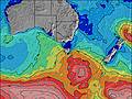 | 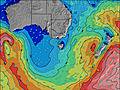 | 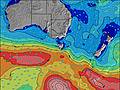 | 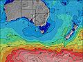 | |||||||||||||
Wave Height (m) Direction Period (s) | SW 12 | SW 12 | SW 17 | SW 17 | SW 16 | SW 16 | SW 16 | SW 15 | SW 14 | WSW 15 | SW 13 | SW 12 | SW 12 | SW 14 | SSW 14 | SW 18 | SW 17 | SW 16 | SW 16 | SW 15 |
Wave Graph | ||||||||||||||||||||
428 | 347 | 663 | 1882 | 2220 | 1591 | 1281 | 949 | 813 | 372 | 2677 | 2826 | 1818 | 597 | 419 | 328 | 418 | 248 | 437 | 674 | |
Wind (km/h) | ||||||||||||||||||||
Wind State on-shore cross-onshore cross-shore cross-offshore off-shore glassy | cross | cross-off | cross-off | cross-off | cross-off | cross-off | cross-off | off | cross-off | cross-off | cross-off | cross-off | cross-off | cross-off | cross-off | cross-off | cross-off | off | cross-on | cross-off |
High Tide | 00:54AM1.30m | 1:50PM1.72m | 1:40AM1.38m | 2:18PM1.73m | 2:21AM1.46m | 2:43PM1.73m | 3:01AM1.54m | 3:08PM1.70m | 3:40AM1.60m | 3:32PM1.67m | 4:21AM1.63m | 3:58PM1.63m | ||||||||
Low Tide | 7:38PM0.72m | 7:04AM0.34m | 8:07PM0.61m | 7:44AM0.35m | 8:34PM0.50m | 8:21AM0.37m | 9:01PM0.39m | 8:57AM0.43m | 9:28PM0.30m | 9:33AM0.50m | 9:57PM0.22m | 10:10AM0.60m | 10:29PM0.16m | |||||||
— | — | 7:26 | — | — | 7:26 | — | — | 7:24 | — | — | 7:24 | — | — | 7:22 | — | — | 7:22 | — | — | |
5:34 | — | — | 5:34 | — | — | 5:35 | — | — | 5:36 | — | — | 5:37 | — | — | 5:37 | — | — | 5:38 | — | |
mm | — | — | — | — | — | — | — | 4 | 1 | 10 | 2 | — | — | — | — | — | — | — | — | — |
Temp °C | 12 | 12 | 13 | 14 | 10 | 15 | 15 | 12 | 11 | 9 | 11 | 12 | 13 | 11 | 13 | 13 | 11 | 13 | 12 | 9 |
Feels °C | 10 | 10 | 10 | 11 | 6 | 10 | 9 | 6 | 5 | 3 | 6 | 7 | 8 | 8 | 10 | 10 | 8 | 11 | 10 | 7 |
Swell 1 Height (m) Direction Period (s) | SW 12 | SW 12 | SW 17 | SW 17 | SW 16 | SW 16 | SW 16 | SW 15 | SW 14 | WSW 15 | SW 12 | SW 11 | SSW 10 | SW 14 | SSW 14 | S 7 | SW 17 | SW 16 | SW 16 | SW 15 |
428 | 347 | 663 | 1882 | 2220 | 1591 | 1281 | 949 | 813 | 372 | 925 | 572 | 401 | 597 | 419 | 54 | 418 | 248 | 437 | 674 | |
Swell 2 Height (m) Direction Period (s) | SW 20 | SW 18 | SW 12 | SW 13 | SSE 16 | SSE 16 | E 16 | SW 19 | WSW 16 | SSW 13 | WSW 14 | SW 16 | SW 15 | SW 21 | SW 19 | SW 18 | SW 12 | SW 11 | S 8 | S 8 |
134 | 162 | 202 | 905 | 27 | 26 | 5 | 94 | 177 | 222 | 207 | 159 | 229 | 150 | 299 | 328 | 74 | 63 | 21 | 10 | |
Swell 3 Height (m) Direction Period (s) | S 13 | — | — | — | — | — | — | NE 4 | — | S 13 | SW 17 | WSW 13 | SW 12 | SW 20 | — | SW 14 | S 8 | SSW 8 | — | — |
3 | — | — | — | — | — | — | 4 | — | 4 | 190 | 106 | 36 | 264 | — | 198 | 33 | 22 | — | — | |
Wind waves Height (m) Direction Period (s) | — | — | — | — | — | NNE 4 | NNE 4 | NW 3 | W 8 | SW 6 | SW 13 | SW 12 | SW 12 | — | — | W 3 | — | — | — | — |
— | — | — | — | — | 20 | 10 | 5 | 460 | 28 | 2677 | 2826 | 1818 | — | — | 3 | — | — | — | — | |
Nearest Offshore or Glassy | ||||||||||||||||||||
Distance (km) | 19 | 0 | 0 | 0 | 0 | 1 | 1 | 0 | 16 | 38 | 17 | 14 | 38 | 0 | 0 | 0 | 0 | 0 | 19 | 0 |
Best forecast wave conditions in Cape Otway | ||||||||||||||||||||
Best forecast wave conditions in Australia | ||||||||||||||||||||
Header Global | ||||||||||||||||||||
- Map Icons:
 Break
Break Live Wave Height (m)
 Live Wind Speed (km/h)
 Surf Rating (10 Max)
 Ocean Swells (m)
- Wind Speed (km/h)
Latest Updates


FREE! Surf-Forecast.com widget for your website
The surf report / weather widget below is available to embed on third party websites free of charge and provides a summary of our Kennet Rivermouth/Point surf forecast. Simply grab the html code snippet that we provide and paste it into your own site. You can choose your preferred language and metric/imperial units for the surf forecast feed to suit users of your site. Click here to get the code.
Information about the Kennet Rivermouth/Point Surf forecast
The above surf forecast table for Kennet Rivermouth/Point provides essential information for determining whether the surfing conditions will be good over the next 16 days. A general guide to surfing at Kennet Rivermouth/Point can be found by selecting the local surf guide option on the grey menu. Our Kennet Rivermouth/Point surf forecast is unique since it includes wave energy (power) that defines the real feel of the surf rather than just the height or the period. If you surf the same spot (Kennet Rivermouth/Point) regularly then make a mental note of the wave energy from the surf forecast table each time you go. Very soon you may start to choose your surf days based on the wave energy alone combined with our forecast of favourable offshore wind conditions. Our star ratings will help here and of course you will also find the usual wave height and period predictions on our surf forecasts as well as a full break down of the swell components under our advanced users option (to reveal that, click the little Einstein character under the tide times).
Further information to help with frequently asked questions about our surf forecast for Kennet Rivermouth/Point may be found under the help tab on the top menu and also by moving your mouse over the question marks on the surf forecast table itself. Please always bear in mind that the forecast is for near-shore open water and local factors at each surf break influence the actual breaking wave height, such as the beach / reef profile, water depths offshore and shelter.
Kennet Rivermouth/Point is 73 km (45 miles) from the city of Geelong West. If you plan a holiday in Cape Otway, look for hotels and other accommodation in Geelong West. Geelong West has rooms for a wide range of budgets as well as car hire and transport links.
 Nearest