

Surf Forecasts:

Boneyards surf forecast from 2 Aug 2026:
- Best quality surf: Thursday 6 Aug, 8AM (local time) - 10ft (3.0m), 14s period, SW swell with glassy winds.
- Most powerful swell: Sunday 9 Aug, 5AM (local time) - 11ft (3.5m), 13s period, SW swell with 4,656 kJ wave energy.
- Next surfable swell (1★+): Monday 3 Aug, 2AM (local time) - 7ft (2.1m), 11s period with ESE swell.
Best Forecast Surf Conditions for Boneyards this week:
The surf forecast for Boneyards over the next 16 days: The first swell (rated 1 star or higher) is forecast to arrive on Monday (Aug 03) at 2AM. The primary swell is predicted to be 2.1m and 11s period with a secondary swell of 1.1m and 12s. The wind is predicted to be cross-offshore as the swell arrives.
The most powerful waves expected at Boneyards in the next 16 days are 3.5m 13s and forecast to arrive on Sunday (Aug 09) at 5AM. Winds are predicted to be offshore at the time the swell arrives. The largest open ocean swell (not directed at the beach) is 2.0m 7s period and expected on Saturday (Aug 08) at 8PM.
| Wave Type | Time (SAST) & Date | Wave Height & Period |
|---|---|---|
| Next good surf (1 star+) | 2AM (Mon 3rd Aug) | 7ft (2.1m) 11s |
| Best Surf | 8AM (Thu 6th Aug) | 10ft (3.0m) 14s |
| Most Powerful | 5AM (Sun 9th Aug) | 11ft (3.5m) 13s |
Table - best surf conditions forecast for Boneyards over the next 16 days.
The Lowdown
Alright folks, Rusty here. Let’s have a look at what’s coming down the line for Boneyards. This reef break is exposed and ready to work, and the next couple of weeks have some serious size on offer, but you’ve gotta pick your moments.
We’re kicking off on Sunday, August 2nd. The afternoon has a 7ft swell from the ESE, period at 12 seconds, and combined energy is 1695 (moderate). The wind is a light onshore breeze, so it’s a bit messy. Not the best way to start, and the water is sitting at 63°, which is a bit colder than usual for this time of year.
The real action starts to build on Monday, August 3rd. Monday morning is the standout of the first week. You’ve got a 6ft ESE swell, 11-second period, and glassy conditions with a light NNE breeze. Combined energy is 1408 (moderate). This is clean, well-shaped reef surf for experienced surfers. The wind is perfect, and the swell direction is right in the optimum slot from the SE. This is the one to aim for early on. Monday afternoon gets onshore and drops off, so don’t sleep in.
Tuesday morning, August 4th, is clean again with a 5ft SW swell and a 12-second period, cross-off wind from the N. Combined energy is 1032 (moderate). It’s smaller but still a nice, clean option. Wednesday morning, August 5th, offers a small 4ft E swell, 10-second period, with cross-off wind, but the energy is only 840 (moderate). Thursday morning, August 6th, is where things get serious. An 12ft SW swell, 14-second period, and light cross-off wind. Combined energy is 4764 (strong). This is big, powerful, and clean—only for experts. If you’re good enough, this is a proper session.
Friday, August 7th, gets messy. The morning is 8ft SW, but the wind is cross-on and the conditions are choppy. By the afternoon, it’s an onshore disaster with 25 km/h winds. Skip it. Saturday, August 8th, is back to clean cross-off wind, but the swell is still a solid 8ft SW with 14-second period and 2732 energy (strong). Good for experienced surfers, but the crowds might be around as it’s a spot that can get busy.
Sunday, August 9th, is a write-off. Strong winds at 40 km/h and light rain ruin the surface, even though there’s 10ft of SW swell. That’s kite-surfing weather, not paddle surfing. The following Monday and Tuesday are small and clean, but nothing special.
Now, here’s where it gets wild. Tuesday, August 11th, is predicted to be too big for this break. The swell is 26ft from the SW, with a 14-second period, and the combined energy is a massive 25617 (very strong). The morning is glassy, but honestly, this is dangerous for all but the most elite. The same goes for Wednesday, August 12th, with 20ft S swell, 16-second period, and offshore wind—still too big. The afternoon of the 12th drops to 18ft S, with clean cross-off wind, but it’s still huge. Combined energy is 13460 (very strong). Only for absolute experts.
Thursday, August 13th, is the best of the second week. Morning has an 12ft S swell, 14-second period, light air, and cross-off wind. Combined energy is 4622 (strong). It’s big, but manageable for strong surfers, and the wind is clean. The afternoon is even better, with a 8ft SSE swell, 13-second period, and light cross-off wind. Combined energy is 2779 (strong). This is a far more user-friendly size with excellent conditions.
The rest of the run to August 17th is a mix of onshore winds and smaller, choppy swells. Nothing to write home about. The weekend of the 15th and 16th is ruined by strong onshore winds.
So, for the best on offer: Monday morning, August 3rd, is your clean, glassy winner for the first week. For the second week, Thursday, August 13th, morning and afternoon, gives you the best mix of size, clean conditions, and a manageable swell for experienced surfers.
Rusty.
Short Range ForecastMostly dry. Warm (max 28°C on Tue afternoon, min 18°C on Wed afternoon). Wind will be generally light. | Days 5-7 Weather SummaryMostly dry. Warm (max 20°C on Sat morning, min 13°C on Thu night). Wind will be generally light. | ||||||||||||||||||
Monday 3 | Tuesday 4 | Wednesday 5 | Thursday 6 | Friday 7 | Saturday 8 | ||||||||||||||
Night | AM | PM | Night | AM | PM | Night | AM | PM | Night | AM | PM | Night | AM | PM | Night | AM | PM | Night | |
Swell Height Map |  |  |  |  | 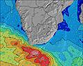 | 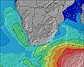 | 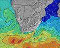 | ||||||||||||
Wave Height (m) Direction Period (s) | ESE 11 | ESE 11 | ESE 11 | E 10 | SW 12 | SW 11 | ESE 10 | E 10 | SW 16 | SW 15 | SW 14 | SW 13 | SW 12 | SW 14 | SW 14 | SW 14 | SW 14 | SW 13 | SW 13 |
Wave Graph | |||||||||||||||||||
1008 | 731 | 698 | 551 | 570 | 418 | 342 | 319 | 1449 | 2278 | 4649 | 3718 | 2183 | 3094 | 2763 | 3143 | 2357 | 1643 | 3718 | |
Wind (km/h) | |||||||||||||||||||
Wind State on-shore cross-onshore cross-shore cross-offshore off-shore glassy | cross-off | cross | on | cross-off | cross-off | cross | cross-off | cross-off | cross-off | off | cross-off | cross-off | off | cross-on | cross-on | cross-off | cross-off | cross-off | cross-off |
High Tide | 6:05AM1.48m | 6:29PM1.60m | 6:40AM1.39m | 7:06PM1.52m | 7:22AM1.28m | 7:53PM1.41m | 8:17AM1.16m | 8:59PM1.29m | 9:50AM1.06m | 10:46PM1.22m | 11:59AM1.09m | 00:33AM1.28m | |||||||
Low Tide | 00:07AM0.21m | 12:10PM0.15m | 00:42AM0.27m | 12:44PM0.24m | 1:24AM0.35m | 1:25PM0.35m | 2:18AM0.45m | 2:21PM0.48m | 3:39AM0.54m | 3:54PM0.59m | 5:36AM0.55m | 6:00PM0.57m | |||||||
— | 7:11 | — | — | 7:09 | — | — | 7:09 | — | — | 7:09 | — | — | 7:07 | — | — | 7:07 | — | — | |
5:39 | — | 5:40 | — | — | 5:42 | — | — | 5:43 | — | — | 5:43 | — | — | 5:44 | — | — | 5:45 | — | |
mm | — | — | — | — | — | — | — | — | — | — | — | — | — | — | — | — | — | — | — |
Temp °C | 21 | 22 | 24 | 22 | 26 | 28 | 23 | 25 | 27 | 16 | 18 | 17 | 15 | 16 | 19 | 17 | 20 | 19 | 15 |
Feels °C | 19 | 20 | 21 | 18 | 22 | 23 | 19 | 23 | 25 | 14 | 16 | 13 | 12 | 12 | 15 | 15 | 17 | 16 | 12 |
Swell 1 Height (m) Direction Period (s) | ESE 11 | ESE 11 | ESE 11 | E 10 | E 10 | ESE 10 | ESE 10 | E 10 | SW 16 | SW 15 | SW 14 | SW 13 | SW 12 | SW 14 | SW 14 | SW 14 | SW 14 | SW 13 | E 9 |
1008 | 731 | 698 | 551 | 459 | 342 | 342 | 319 | 1449 | 2278 | 4649 | 3718 | 2183 | 3094 | 2763 | 3143 | 2357 | 1643 | 126 | |
Swell 2 Height (m) Direction Period (s) | SW 12 | SW 13 | SW 13 | SW 12 | SW 12 | SW 11 | SW 11 | SW 11 | E 10 | E 10 | E 9 | E 10 | SSW 16 | E 10 | — | E 8 | E 9 | E 9 | — |
324 | 673 | 643 | 537 | 570 | 418 | 303 | 220 | 267 | 148 | 113 | 92 | 808 | 65 | — | 382 | 365 | 188 | — | |
Swell 3 Height (m) Direction Period (s) | SSW 15 | S 13 | S 13 | — | S 12 | SW 18 | SSW 16 | SW 14 | SW 10 | — | — | SSW 20 | E 10 | — | — | — | — | — | — |
283 | 4 | 3 | — | 3 | 13 | 99 | 305 | 139 | — | — | 75 | 66 | — | — | — | — | — | — | |
Wind waves Height (m) Direction Period (s) | — | — | — | — | — | — | W 4 | — | — | SW 6 | — | — | — | — | E 10 | — | W 4 | WSW 6 | SW 13 |
— | — | — | — | — | — | 10 | — | — | 75 | — | — | — | — | 116 | — | 12 | 266 | 3718 | |
Nearest Offshore or Glassy | |||||||||||||||||||
Distance (km) | 0 | 8 | 29 | 0 | 0 | 8 | 0 | 0 | 1 | 0 | 0 | 0 | 0 | 51 | 181 | 0 | 0 | 0 | 0 |
Best forecast wave conditions in Eastern Cape (South) | |||||||||||||||||||
Best forecast wave conditions in South Africa | |||||||||||||||||||
Header Global | |||||||||||||||||||
- Map Icons:
 Break
Break Live Wave Height (m)
 Live Wind Speed (km/h)
 Surf Rating (10 Max)
 Ocean Swells (m)
- Wind Speed (km/h)
Latest Updates


FREE! Surf-Forecast.com widget for your website
The surf report / weather widget below is available to embed on third party websites free of charge and provides a summary of our Boneyards surf forecast. Simply grab the html code snippet that we provide and paste it into your own site. You can choose your preferred language and metric/imperial units for the surf forecast feed to suit users of your site. Click here to get the code.
Information about the Boneyards Surf forecast
The above surf forecast table for Boneyards provides essential information for determining whether the surfing conditions will be good over the next 16 days. A general guide to surfing at Boneyards can be found by selecting the local surf guide option on the grey menu. Our Boneyards surf forecast is unique since it includes wave energy (power) that defines the real feel of the surf rather than just the height or the period. If you surf the same spot (Boneyards) regularly then make a mental note of the wave energy from the surf forecast table each time you go. Very soon you may start to choose your surf days based on the wave energy alone combined with our forecast of favourable offshore wind conditions. Our star ratings will help here and of course you will also find the usual wave height and period predictions on our surf forecasts as well as a full break down of the swell components under our advanced users option (to reveal that, click the little Einstein character under the tide times).
Further information to help with frequently asked questions about our surf forecast for Boneyards may be found under the help tab on the top menu and also by moving your mouse over the question marks on the surf forecast table itself. Please always bear in mind that the forecast is for near-shore open water and local factors at each surf break influence the actual breaking wave height, such as the beach / reef profile, water depths offshore and shelter.
Boneyards is 19 km (12 miles) from the city of Kruisfontein. If you plan a holiday in Eastern Cape (South), look for hotels and other accommodation in Kruisfontein. Kruisfontein has rooms for a wide range of budgets as well as car hire and transport links.
 Nearest