

Surf Forecasts:

Mtati surf forecast from 21 Jul 2026:
- Best quality surf: Friday 24 Jul, 5AM (local time) - 10ft (3.0m), 11s period, SW swell with cross-onshore winds.
- Most powerful swell: Friday 24 Jul, 2PM (local time) - 10ft (3.0m), 16s period, SSW swell with 5,061 kJ wave energy.
- Next surfable swell (1★+): Tuesday 21 Jul, 11PM (local time) - 7ft (2.2m), 14s period with SSW swell.
Best Forecast Surf Conditions for Mtati this week:
The surf forecast for Mtati over the next 16 days: The first swell (rated 1 star or higher) is forecast to arrive on Tuesday (Jul 21) at 11PM. The primary swell is predicted to be 2.2m and 14s period with a secondary swell of 1.2m and 11s. The wind is predicted to be offshore as the swell arrives.
The most powerful waves expected at Mtati in the next 16 days are 3.0m 16s and forecast to arrive on Friday (Jul 24) at 2PM. Winds are predicted to be cross-onshore at the time the swell arrives. The largest open ocean swell (not directed at the beach) is 1.7m 8s period and expected on Sunday (Jul 26) at 8PM.
| Wave Type | Time (SAST) & Date | Wave Height & Period |
|---|---|---|
| Next good surf (1 star+) | 11PM (Tue 21st Jul) | 7ft (2.2m) 14s |
| Best Surf | 5AM (Fri 24th Jul) | 10ft (3.0m) 11s |
| Most Powerful | 2PM (Fri 24th Jul) | 10ft (3.0m) 16s |
Table - best surf conditions forecast for Mtati over the next 16 days.
The Lowdown
Alright folks, Rusty here. Let’s get stuck into the outlook for the next couple of weeks. We’ve got one spot on the radar, and it’s a bit of a mixed bag, so let’s break it down.
First up, the overall pattern. We’ve got a solid run of groundswell coming through, but the wind is going to be the main character in this story. For the first few days, there’s a fair bit of onshore wind mucking things up, but there are clear windows of glassy or offshore conditions that will make it all worthwhile. The water temp is about average for the time of year, so nothing unusual there.
The real standout of the whole period is Friday morning, 24th July. We’ve got a clean 8ft SSW groundswell with a very long period of 16 seconds pushing in. The combined swell energy is strong, clocking in at 4215. The wind is light, so there will be a few ripples, but it’s manageable. This is a big swell for the river mouth, and it’s going to be working. The longer period means the sets will have some real punch, and the gaps between them will make paddling out a bit easier. For experienced surfers, this is the pick of the bunch.
But hold on. Saturday morning, 25th July is also a winner. The swell drops slightly to 7ft, still from the SSW, with a solid 14-second period. The kicker? The wind is dead calm – glassy as a mirror. The combined energy is still strong at 1705. This is going to be smooth, clean, and powerful. If you can get out there, you’ll be grinning.
Now, for the rest of the week. Wednesday afternoon the 22nd is a write-off with a strong 12 mph onshore wind. Thursday is a scratch session too. The Friday afternoon 24th sees the swell jump to 10ft, which is too big for this spot, so give it a miss unless you’re a pro. Saturday afternoon 25th is clean but smaller.
Sunday, 26th July, is a good shout. The morning session has a 6ft SSW swell with a 12-second period, and a gentle offshore wind from the NE. It’s clean, it’s working, and the combined energy is 831 – moderate. The afternoon drops off a bit but stays clean.
Then we hit a bit of a lull. Monday 27th and Tuesday 28th are messy with strong onshore winds, though Tuesday morning has a glassy 10ft S swell that is too big for the break. The rest of the week is a write-off with choppy, onshore conditions. The only glimmer is Wednesday morning, 5th August, which has a 3ft SSW groundswell with a very long 16-second period, but the wind is light cross-onshore. It’s not going to be clean, but there’s a bit of energy there (787).
After that, the swell flatlines. The last few days of the outlook are tiny, with onshore winds, and not worth paddling out for. There’s a gap of several days from the 30th of July through to the 3rd of August that are pretty poor, with only a few marginal windows.
So, to sum it up: Friday morning, 24th July and Saturday morning, 25th July are your two standouts. The first is a big, long-period groundswell with light wind, and the second is glassy and clean. Get on it. After that, it’s a waiting game.
Rusty.
Short Range ForecastModerate rain (total 11mm), heaviest on Thu night. Very mild (max 19°C on Wed morning, min 14°C on Tue night). Winds increasing (calm on Wed morning, strong winds from the WSW by Thu night). | Days 5-7 Weather SummaryMostly dry. Warm (max 25°C on Sun afternoon, min 14°C on Fri night). Winds increasing (calm on Sat morning, fresh winds from the SW by Mon afternoon). | ||||||||||||||||||
Wednesday 22 | Thursday 23 | Friday 24 | Saturday 25 | Sunday 26 | Monday 27 | ||||||||||||||
Night | AM | PM | Night | AM | PM | Night | AM | PM | Night | AM | PM | Night | AM | PM | Night | AM | PM | Night | |
Swell Height Map |  |  |  |  | 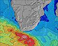 | 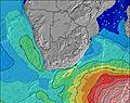 | 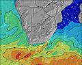 | ||||||||||||
Wave Height (m) Direction Period (s) | SSW 13 | SSW 13 | SSW 12 | SSW 12 | SSW 12 | SW 12 | SSW 11 | SSW 16 | SSW 16 | SSW 15 | SSW 14 | SSW 13 | SSW 13 | SSW 12 | SSW 12 | SSW 12 | SSW 12 | SSW 12 | SW 12 |
Wave Graph | |||||||||||||||||||
1708 | 1083 | 843 | 905 | 614 | 1229 | 1908 | 2777 | 4649 | 2261 | 1601 | 1496 | 1321 | 816 | 605 | 625 | 771 | 795 | 505 | |
Wind (km/h) | |||||||||||||||||||
Wind State on-shore cross-onshore cross-shore cross-offshore off-shore glassy | off | glassy | on | cross-on | cross-on | cross-on | on | cross-on | cross-off | off | glassy | cross-off | off | off | cross-off | cross-off | cross-on | on | glassy |
High Tide | 8:43PM1.22m | 9:04AM1.01m | 9:48PM1.11m | 10:41AM0.94m | 11:27PM1.07m | 12:37PM0.97m | 00:57AM1.11m | 1:46PM1.07m | 1:54AM1.19m | 2:30PM1.17m | 2:35AM1.29m | 3:05PM1.28m | 3:09AM1.38m | ||||||
Low Tide | 3:06AM0.57m | 3:01PM0.58m | 4:25AM0.63m | 4:30PM0.66m | 6:14AM0.62m | 6:26PM0.65m | 7:32AM0.54m | 7:41PM0.58m | 8:18AM0.44m | 8:27PM0.48m | 8:54AM0.34m | 9:03PM0.38m | |||||||
— | 7:09 | — | — | 7:09 | — | — | 7:09 | — | — | 7:07 | — | — | 7:07 | — | — | 7:07 | — | — | |
5:24 | — | 5:24 | — | — | 5:25 | — | — | 5:27 | — | — | 5:27 | — | — | 5:28 | — | — | 5:29 | — | |
mm | — | — | — | — | — | — | 9 | 2 | — | — | — | — | — | — | — | — | — | — | — |
Temp °C | 16 | 19 | 19 | 15 | 17 | 17 | 16 | 16 | 16 | 16 | 16 | 17 | 16 | 20 | 25 | 24 | 21 | 20 | 19 |
Feels °C | 15 | 18 | 17 | 12 | 14 | 12 | 8 | 14 | 14 | 13 | 16 | 16 | 13 | 16 | 21 | 19 | 18 | 15 | 19 |
Swell 1 Height (m) Direction Period (s) | SSW 13 | SSW 13 | SSW 12 | SSW 12 | SSW 12 | SE 12 | SE 12 | SSW 16 | SSW 16 | SSW 15 | SSW 14 | SSW 13 | SSW 13 | SSW 12 | SSW 12 | SSW 12 | SSW 12 | SSW 12 | SW 12 |
1708 | 1083 | 843 | 905 | 614 | 112 | 66 | 2777 | 4649 | 2261 | 1601 | 1496 | 1321 | 816 | 605 | 625 | 771 | 795 | 505 | |
Swell 2 Height (m) Direction Period (s) | ESE 11 | ESE 12 | ESE 12 | SE 12 | SE 12 | ENE 8 | SSW 20 | SSW 12 | ESE 11 | SE 8 | SE 8 | SE 8 | SE 10 | ENE 6 | SE 9 | ENE 8 | ENE 8 | ENE 8 | S 6 |
323 | 280 | 247 | 205 | 142 | 40 | 225 | 1377 | 47 | 154 | 104 | 77 | 33 | 88 | 3 | 326 | 164 | 103 | 73 | |
Swell 3 Height (m) Direction Period (s) | E 9 | ENE 4 | ENE 5 | E 7 | ENE 8 | — | NE 8 | SE 11 | — | — | — | SE 10 | E 10 | SE 10 | SE 9 | — | — | SSW 16 | SSW 15 |
7 | 3 | 9 | 22 | 51 | — | 18 | 61 | — | — | — | 24 | 2 | 15 | 3 | — | — | 151 | 308 | |
Wind waves Height (m) Direction Period (s) | — | ENE 4 | — | SW 4 | SW 6 | SW 12 | SSW 11 | — | — | — | — | — | ENE 5 | ENE 6 | ENE 7 | — | WSW 5 | SSW 5 | — |
— | 12 | — | 26 | 59 | 1229 | 1908 | — | — | — | — | — | 59 | 136 | 172 | — | 44 | 72 | — | |
Nearest Offshore or Glassy | |||||||||||||||||||
Distance (km) | 0 | 0 | 95 | 16 | 16 | 151 | 141 | 8 | 158 | 0 | 0 | 0 | 0 | 0 | 141 | 21 | 95 | 151 | 0 |
Best forecast wave conditions in Eastern Cape (South) | |||||||||||||||||||
Best forecast wave conditions in South Africa | |||||||||||||||||||
Header Global | |||||||||||||||||||
- Map Icons:
 Break
Break Live Wave Height (m)
 Live Wind Speed (km/h)
 Surf Rating (10 Max)
 Ocean Swells (m)
- Wind Speed (km/h)


FREE! Surf-Forecast.com widget for your website
The surf report / weather widget below is available to embed on third party websites free of charge and provides a summary of our Mtati surf forecast. Simply grab the html code snippet that we provide and paste it into your own site. You can choose your preferred language and metric/imperial units for the surf forecast feed to suit users of your site. Click here to get the code.
Information about the Mtati Surf forecast
The above surf forecast table for Mtati provides essential information for determining whether the surfing conditions will be good over the next 16 days. A general guide to surfing at Mtati can be found by selecting the local surf guide option on the grey menu. Our Mtati surf forecast is unique since it includes wave energy (power) that defines the real feel of the surf rather than just the height or the period. If you surf the same spot (Mtati) regularly then make a mental note of the wave energy from the surf forecast table each time you go. Very soon you may start to choose your surf days based on the wave energy alone combined with our forecast of favourable offshore wind conditions. Our star ratings will help here and of course you will also find the usual wave height and period predictions on our surf forecasts as well as a full break down of the swell components under our advanced users option (to reveal that, click the little Einstein character under the tide times).
Further information to help with frequently asked questions about our surf forecast for Mtati may be found under the help tab on the top menu and also by moving your mouse over the question marks on the surf forecast table itself. Please always bear in mind that the forecast is for near-shore open water and local factors at each surf break influence the actual breaking wave height, such as the beach / reef profile, water depths offshore and shelter.
Are you planning a holiday in Eastern Cape (South)? If you are looking for accommodation near Mtati, camping, hotels and holiday cottages in Eastern Cape (South), consider staying in Port Alfred which is 20 km (12 miles) away. Other places in and around Eastern Cape (South) where you can find information about places to rent, and car hire include Grahamstown which is 57 km (35 miles) away, Bisho, Fort Beaufort and East London.
 Nearest