

Surf Forecasts:

Black Rocks surf forecast from 3 Aug 2026:
- Most powerful swell: Saturday 8 Aug, 1PM (local time) - 4.5ft (1.3m), 18s period, SSW swell with 986 kJ wave energy.
Best Forecast Surf Conditions for Black Rocks this week:
The most powerful waves expected at Black Rocks in the next 16 days are 1.3m 18s and forecast to arrive on Saturday (Aug 08) at 1PM. Winds are predicted to be cross-shore at the time the swell arrives. The largest open ocean swell (not directed at the beach) is 1.3m 9s period and expected on Wednesday (Aug 05) at 4PM.
| Wave Type | Time (+04) & Date | Wave Height & Period |
|---|---|---|
| Next good surf (1 star+) | - | - |
| Best Surf | - | - |
| Most Powerful | 1PM (Sat 8th Aug) | 4.5ft (1.3m) 18s |
Table - best surf conditions forecast for Black Rocks over the next 16 days.
The Lowdown
Alright, listen up, surfers. Rusty here. It’s been a bit of a flat, messy stretch lately, but we’ve got a run of surf coming in the second half of the 16-day window that’s worth keeping an eye on. First thing, though, we’ve got a gap. There’s nothing really worth paddling out for from Monday, August 3rd, right through to the end of the first week. It’s not you, it’s the ocean – just a dead run of small, cross-shore junk with nothing to get excited about. That’s about a week with no real recommendations.
The first real action starts to flicker around Monday, August 10th, but it’s still marginal. The stand-out window is the weekend of Saturday, August 15th, and into the following week. That’s where the real energy shows up.
Let’s talk about the main event. The only spot that’s been highlighted for us is Black Rocks, a reef break that’s intermediate territory and pretty exposed to the south-west. It’s an inconsistent little wave, so when it turns on, it’s a treat – but it also means you might be sharing it with the few who know. The water temp is sitting at a nice 77°F, which is a touch warmer than normal for this time of year, so you won’t need a thick suit.
The first proper pulse of energy comes through on Saturday, August 15th. The swell direction is from the S and SSW, with a period that hits 20 seconds on the afternoon – that’s proper, long-period groundswell energy. The combined energy shoots up to 3552 (strong wave energy), and we’re looking at waves around 6 ft to 6 ft. Now, that 6 ft mark is getting into the zone where it’s a bit much for beginners. For the rest of you, it’s a solid, powerful wave, but that long period can make it break a bit straight on a beach break – here at Black Rocks, a reef, it should be fine. The wind is cross-shore and moderate, which is a bit of a bummer, so it’s not going to be super clean. It’s a bit lumpy, but there’s real grunt in the water.
Then, Sunday, August 16th gets serious. The swell picks up to 8 ft from the SSW, with a combined energy of 4403 (very strong wave energy). That is big, and it’s only for the experts. The period is 18 seconds, so it’s still a long, powerful groundswell. The wind is cross-onshore and fresh, blasting it at 19 mph, so the surface is going to be lumpy and messy. This is less about pretty waves and more about heavy, challenging conditions. If you’re not solid on a big board, stay on the beach.
Looking into Monday, August 17th, the swell drops back to 7 ft and 6 ft, still with that strong energy (2054 and 1630). The wind eases a touch but stays cross-shore, keeping things a bit lumpy. It’s still chunky, but the period drops to 15-16 seconds, so it’s a bit more manageable. This is the best of the big stuff for the intermediate crew who can handle it.
Finally, Tuesday, August 18th brings a bit of relief. The swell drops to 4 ft to 5 ft from the SW and SSW, with a period of 14 seconds. The combined energy is still moderate (960-973), but the wind finally swings cross-offshore from the east at 9 to 12 mph. That’s the cleanest it’s been all week. The waves are smaller, but they’ll be glassy and lined up. This is the one for the everyday surfer looking for a fun, clean session without the washing machine.
So, to wrap it up: the first week is a write-off. The weekend of the 15th and 16th is for the big-wave hunters, but it’s messy. The real standout for clean, fun waves is Tuesday, August 18th. Keep your eyes peeled on the forecast, because this long-range stuff can shift, but it’s looking promising.
Rusty.
Short Range ForecastLight rain (total 5mm), mostly falling on Tue morning. Warm (max 24°C on Tue afternoon, min 21°C on Mon night). Mainly fresh winds. | Days 5-7 Weather SummaryLight rain (total 4mm), mostly falling on Thu afternoon. Warm (max 24°C on Fri morning, min 21°C on Thu night). Mainly fresh winds. | |||||||||||||||||||
Mon 3 | Tuesday 4 | Wednesday 5 | Thursday 6 | Friday 7 | Saturday 8 | Sunday 9 | ||||||||||||||
PM | Night | AM | PM | Night | AM | PM | Night | AM | PM | Night | AM | PM | Night | AM | PM | Night | AM | PM | Night | |
Swell Height Map |  | 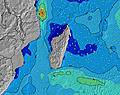 | 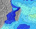 | 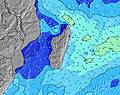 | 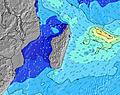 | 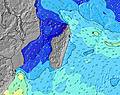 | 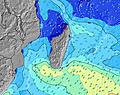 | |||||||||||||
Wave Height (m) Direction Period (s) | S 17 | S 15 | S 13 | S 13 | S 12 | SSW 16 | SSW 15 | SSW 14 | SW 14 | SSW 13 | SSW 13 | SSW 13 | SW 12 | SSW 21 | SSW 18 | SSW 18 | SSW 16 | SW 15 | SW 14 | SW 14 |
Wave Graph | ||||||||||||||||||||
465 | 287 | 229 | 219 | 199 | 215 | 291 | 264 | 272 | 229 | 222 | 212 | 149 | 685 | 839 | 817 | 683 | 543 | 412 | 459 | |
Wind (km/h) | ||||||||||||||||||||
Wind State on-shore cross-onshore cross-shore cross-offshore off-shore glassy | cross-off | cross-off | cross-off | cross-off | cross-off | cross-off | cross-off | cross | cross-off | cross | cross | cross | cross | cross | cross | cross | cross | cross-off | cross | cross |
High Tide | 3:27AM0.59m | 4:00PM0.62m | 4:12AM0.53m | 4:43PM0.58m | 5:18AM0.45m | 5:46PM0.54m | 7:51AM0.41m | 7:41PM0.51m | 10:27AM0.45m | 9:35PM0.54m | 11:24AM0.52m | 10:44PM0.60m | ||||||||
Low Tide | 9:32PM0.20m | 9:39AM0.16m | 10:18PM0.22m | 10:14AM0.22m | 11:23PM0.24m | 11:04AM0.29m | 1:17AM0.25m | 1:00PM0.34m | 3:26AM0.20m | 3:33PM0.33m | 4:39AM0.12m | 4:48PM0.28m | ||||||||
— | — | 6:39 | — | — | 6:39 | — | — | 6:37 | — | — | 6:37 | — | — | 6:37 | — | — | 6:35 | — | — | |
5:52 | — | — | 5:53 | — | — | 5:53 | — | — | 5:53 | — | — | 5:54 | — | — | 5:54 | — | — | 5:54 | — | |
mm | — | — | 2 | — | — | 2 | — | — | 1 | 2 | 1 | — | — | — | — | — | — | 1 | — | — |
Temp °C | 23 | 22 | 23 | 24 | 22 | 24 | 23 | 22 | 23 | 23 | 22 | 24 | 24 | 22 | 24 | 24 | 22 | 23 | 23 | 22 |
Feels °C | 20 | 19 | 21 | 21 | 20 | 21 | 20 | 20 | 21 | 20 | 20 | 21 | 21 | 19 | 21 | 21 | 20 | 20 | 19 | 19 |
Swell 1 Height (m) Direction Period (s) | SW 14 | ENE 10 | S 13 | ENE 10 | S 12 | S 12 | SSW 15 | SSW 14 | SW 14 | SSW 13 | SSW 13 | SSW 13 | NE 8 | SSW 21 | SSW 18 | SSW 18 | SSW 16 | SW 15 | SW 14 | SW 14 |
373 | 154 | 229 | 125 | 199 | 184 | 291 | 264 | 272 | 229 | 222 | 212 | 72 | 685 | 839 | 817 | 683 | 543 | 412 | 459 | |
Swell 2 Height (m) Direction Period (s) | S 17 | S 15 | NE 10 | S 13 | ENE 10 | NE 10 | ENE 10 | SSE 11 | NE 10 | NE 8 | ENE 10 | NE 9 | SW 12 | ENE 10 | NE 10 | SSE 7 | ENE 10 | SSE 7 | ENE 10 | NE 10 |
465 | 287 | 98 | 219 | 125 | 98 | 122 | 135 | 98 | 74 | 117 | 84 | 149 | 125 | 106 | 54 | 69 | 38 | 117 | 98 | |
Swell 3 Height (m) Direction Period (s) | NE 10 | SW 13 | SW 13 | SW 13 | SW 12 | SSW 16 | SSE 8 | NE 10 | SSE 11 | SSE 9 | S 18 | SSW 16 | S 15 | SSW 13 | SSW 12 | NE 10 | SSW 11 | SSE 10 | SSW 18 | SSE 10 |
137 | 171 | 109 | 82 | 72 | 215 | 45 | 98 | 65 | 46 | 25 | 85 | 109 | 186 | 127 | 96 | 68 | 19 | 209 | 18 | |
Wind waves Height (m) Direction Period (s) | SSE 7 | — | SE 7 | ESE 3 | ESE 3 | E 3 | ESE 9 | SE 8 | ESE 3 | ESE 3 | SE 7 | SE 7 | SE 7 | SSE 7 | SSE 7 | SE 8 | SSE 7 | ENE 8 | SSE 8 | SE 7 |
37 | — | 33 | 2 | 3 | 1 | 238 | 158 | 2 | 2 | 84 | 62 | 44 | 59 | 57 | 179 | 51 | 127 | 50 | 53 | |
Nearest Offshore or Glassy | ||||||||||||||||||||
Distance (km) | 227 | 6 | 199 | 227 | 6 | 18 | 227 | 6 | 199 | 227 | 199 | 227 | 227 | 6 | 227 | 227 | 6 | 227 | 227 | 227 |
Best forecast wave conditions in Mauritius | ||||||||||||||||||||
Best forecast wave conditions in Mauritius | ||||||||||||||||||||
Header Global | ||||||||||||||||||||
- Map Icons:
 Break
Break Live Wave Height (m)
 Live Wind Speed (km/h)
 Surf Rating (10 Max)
 Ocean Swells (m)
- Wind Speed (km/h)
Latest Updates


FREE! Surf-Forecast.com widget for your website
The surf report / weather widget below is available to embed on third party websites free of charge and provides a summary of our Black Rocks surf forecast. Simply grab the html code snippet that we provide and paste it into your own site. You can choose your preferred language and metric/imperial units for the surf forecast feed to suit users of your site. Click here to get the code.
Information about the Black Rocks Surf forecast
The above surf forecast table for Black Rocks provides essential information for determining whether the surfing conditions will be good over the next 16 days. A general guide to surfing at Black Rocks can be found by selecting the local surf guide option on the grey menu. Our Black Rocks surf forecast is unique since it includes wave energy (power) that defines the real feel of the surf rather than just the height or the period. If you surf the same spot (Black Rocks) regularly then make a mental note of the wave energy from the surf forecast table each time you go. Very soon you may start to choose your surf days based on the wave energy alone combined with our forecast of favourable offshore wind conditions. Our star ratings will help here and of course you will also find the usual wave height and period predictions on our surf forecasts as well as a full break down of the swell components under our advanced users option (to reveal that, click the little Einstein character under the tide times).
Further information to help with frequently asked questions about our surf forecast for Black Rocks may be found under the help tab on the top menu and also by moving your mouse over the question marks on the surf forecast table itself. Please always bear in mind that the forecast is for near-shore open water and local factors at each surf break influence the actual breaking wave height, such as the beach / reef profile, water depths offshore and shelter.
Black Rocks is 12 km (7 miles) from the city of Vacoas. If you plan a holiday in Mauritius, look for hotels and other accommodation in Vacoas. Vacoas has rooms for a wide range of budgets as well as car hire and transport links.
 Nearest