

Surf Forecasts:

Passe de L'Ambulante surf forecast from 30 Jul 2026:
- Best quality surf: Thursday 30 Jul, 10AM (local time) - 5ft (1.6m), 13s period, SSW swell with offshore winds.
- Most powerful swell: Thursday 30 Jul, 7PM (local time) - 6ft (1.8m), 16s period, SSW swell with 1,671 kJ wave energy.
- Next surfable swell (1★+): Thursday 30 Jul, 10AM (local time) - 5ft (1.6m), 13s period with SSW swell.
Best Forecast Surf Conditions for Passe de L'Ambulante this week:
The surf forecast for Passe de L'Ambulante over the next 16 days: The first swell (rated 1 star or higher) is forecast to arrive on Thursday (Jul 30) at 10AM. The primary swell is predicted to be 1.6m and 13s period with a secondary swell of 0.9m and 18s. The wind is predicted to be offshore as the swell arrives.
The most powerful waves expected at Passe de L'Ambulante in the next 16 days are 1.8m 16s and forecast to arrive on Thursday (Jul 30) at 7PM. Winds are predicted to be offshore at the time the swell arrives. The largest open ocean swell (not directed at the beach) is 2.1m 10s period and expected on Wednesday (Aug 05) at 10AM.
| Wave Type | Time (+04) & Date | Wave Height & Period |
|---|---|---|
| Next good surf (1 star+) | 10AM (Thu 30th Jul) | 5ft (1.6m) 13s |
| Best Surf | 10AM (Thu 30th Jul) | 5ft (1.6m) 13s |
| Most Powerful | 7PM (Thu 30th Jul) | 6ft (1.8m) 16s |
Table - best surf conditions forecast for Passe de L'Ambulante over the next 16 days.
The Lowdown
Alright folks, Rusty here. We've got a solid run of surf on the cards for Passe de L'Ambulante over the next couple of weeks, so no need to wait around. The water is sitting at 77°, which is a touch warmer than normal for this time of year, so you can leave the wetsuit at home.
The standout period is going to be the next few days, starting right now. Thursday morning is looking very clean with a light offshore breeze from the ESE. The swell is a proper 5ft from the SSW, with a long 13-second period giving it plenty of punch. The combined wave energy is strong at 1281, and it's going to be grooming nicely. This is perfect for the experienced crew on the reef. Thursday afternoon sees a rain shower roll through, but the wind stays offshore, and the swell shifts to a very long 17-second period, dropping to 4ft. Still a hell of a lot of energy in the water (1225) and super clean.
Friday morning is also solid. The swell bumps up to 6ft from the SW (1551 energy), and the wind is a cross-offshore breeze. It's still clean, but the tide might be a bit tricky. Friday afternoon the wind swings back to a clean offshore, with 6ft of SSW swell (1460 energy). Saturday is the pick of the first week. The morning has 6ft of super clean SSW swell (1611 energy) with a moderate offshore wind. It's a bit on the bigger side, so this is expert territory. The afternoon holds the same size but the wind picks up to a fresh breeze – still offshore, but it'll be a bit more challenging.
Sunday holds strong with 6ft of SSW swell in the morning with a clean offshore wind. The afternoon sees the wind go cross-off again, but it's still a fun 6ft. The swell starts to back off a bit on Monday, dropping to 3ft, but the wind is a fresh offshore, so it remains clean. The energy is dropping to 1127, so it's still got some grunt.
Now, looking further out, the second week gets interesting again. There's a bit of a lull in the middle of the week, but by Thursday the 12th of August, things fire back up. The morning of the 12th is looking like a real gem. The wind is a light offshore breeze, and the swell is a 4ft groundswell from the south with a very long 20-second period. That's a massive amount of energy at 1677. This is a reef pass, so that long period will wrap in beautifully. The afternoon of the 12th is just as good, with 5ft of S swell and a gentle offshore wind giving 1886 energy. This is a serious contender for the best window.
The 13th of August keeps the quality high with 5ft of SSW swell and glassy, near-calm conditions in the morning. The 14th of August looks like the real finale though. Friday morning the 14th has 6ft of clean SSW swell with a gentle offshore wind and a massive 1850 energy. That's a powerful, clean swell for the experts with offshore winds locked in.
Overall, this is a great run. The water is warm, the winds are predominantly offshore, and the swell is consistent. The first few days are the most reliable, but the second week, especially the 12th and 14th of August, has some serious potential, though it's a bit further out so keep an eye on it. Passe de L'Ambulante is very consistent here, so it’s a solid bet. Keep in mind it's a reef break, so it's for the experienced crew, and it can get crowded, so pack your patience.
Stay stoked,
Rusty
Short Range ForecastLight rain (total 9mm), mostly falling on Thu night. Warm (max 25°C on Thu afternoon, min 22°C on Thu night). Mainly fresh winds. | Days 4-6 Weather SummaryMostly dry. Warm (max 25°C on Sun morning, min 22°C on Mon night). Mainly fresh winds. | ||||||||||||||||||||
Thursday 30 | Friday 31 | Saturday 1 | Sunday 2 | Monday 3 | Tuesday 4 | Wednesday 5 | |||||||||||||||
AM | PM | Night | AM | PM | Night | AM | PM | Night | AM | PM | Night | AM | PM | Night | AM | PM | Night | AM | PM | Night | |
Swell Height Map | 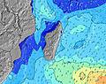 | 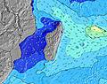 | 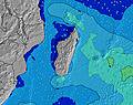 | 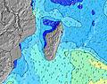 | 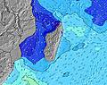 | 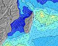 | 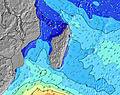 | ||||||||||||||
Wave Height (m) Direction Period (s) | SSW 13 | SW 17 | SW 16 | SW 16 | SSW 16 | SSW 15 | SSW 15 | SSW 15 | SSW 14 | SSW 14 | SSW 16 | SSW 15 | S 18 | SW 14 | S 15 | SE 10 | S 13 | S 12 | SE 10 | SSW 15 | SSW 14 |
Wave Graph | |||||||||||||||||||||
837 | 647 | 1591 | 1551 | 1460 | 1174 | 1611 | 1568 | 1042 | 1319 | 1379 | 829 | 613 | 390 | 215 | 296 | 171 | 107 | 152 | 393 | 437 | |
Wind (km/h) | |||||||||||||||||||||
Wind State on-shore cross-onshore cross-shore cross-offshore off-shore glassy | off | off | cross-off | cross-off | off | off | off | off | off | off | cross-off | cross-off | off | off | off | off | off | off | off | off | off |
High Tide | 1:35PM0.63m | 1:17AM0.72m | 1:59PM0.65m | 1:46AM0.72m | 2:24PM0.67m | 2:15AM0.70m | 2:51PM0.67m | 2:46AM0.67m | 3:21PM0.66m | 3:22AM0.62m | 3:55PM0.64m | 4:05AM0.55m | 4:37PM0.60m | ||||||||
Low Tide | 7:19PM0.18m | 7:47AM0.04m | 7:47PM0.17m | 8:12AM0.05m | 8:16PM0.17m | 8:37AM0.08m | 8:49PM0.18m | 9:04AM0.11m | 9:25PM0.20m | 9:34AM0.16m | 10:10PM0.22m | 10:08AM0.22m | 11:13PM0.25m | ||||||||
6:41 | — | — | 6:41 | — | — | 6:41 | — | — | 6:41 | — | — | 6:39 | — | — | 6:39 | — | — | 6:39 | — | — | |
— | 5:52 | — | — | 5:52 | — | — | 5:52 | — | — | 5:52 | — | — | 5:52 | — | — | 5:53 | — | — | 5:53 | — | |
mm | — | 2 | 6 | — | — | — | — | 1 | — | — | — | — | — | — | — | — | — | — | 1 | — | 1 |
Temp °C | 24 | 25 | 22 | 25 | 24 | 22 | 25 | 24 | 23 | 25 | 25 | 23 | 24 | 24 | 23 | 24 | 24 | 23 | 25 | 24 | 22 |
Feels °C | 23 | 24 | 22 | 25 | 22 | 21 | 23 | 21 | 21 | 23 | 23 | 22 | 20 | 21 | 21 | 22 | 22 | 22 | 24 | 22 | 21 |
Swell 1 Height (m) Direction Period (s) | SSW 13 | SSW 13 | SW 16 | SW 16 | SSW 16 | SSW 15 | SSW 15 | SSW 15 | SSW 14 | SSW 14 | SSW 16 | SSW 15 | SW 14 | SW 14 | SW 13 | S 13 | S 13 | S 12 | SE 10 | SSW 15 | SSW 14 |
837 | 578 | 1591 | 1551 | 1460 | 1174 | 1611 | 1568 | 1042 | 1319 | 1379 | 829 | 514 | 390 | 212 | 176 | 171 | 107 | 137 | 393 | 437 | |
Swell 2 Height (m) Direction Period (s) | SW 18 | SW 17 | ESE 10 | ESE 9 | ESE 9 | SSW 18 | ESE 8 | — | SSW 18 | S 9 | ESE 8 | S 20 | S 18 | S 17 | S 15 | SW 13 | SW 13 | SW 12 | S 12 | S 12 | S 11 |
444 | 647 | 77 | 86 | 61 | 329 | 46 | — | 459 | 7 | 84 | 485 | 613 | 351 | 215 | 138 | 100 | 72 | 106 | 44 | 21 | |
Swell 3 Height (m) Direction Period (s) | ESE 11 | ESE 11 | — | SE 9 | — | ENE 10 | ENE 10 | — | — | — | — | — | NNE 6 | NE 10 | NNE 6 | NE 10 | SSW 16 | SSW 16 | SSW 15 | NNE 6 | — |
68 | 65 | — | 90 | — | 10 | 10 | — | — | — | — | — | 13 | 27 | 7 | 26 | 26 | 99 | 152 | 8 | — | |
Wind waves Height (m) Direction Period (s) | — | E 9 | E 10 | E 9 | — | ESE 8 | E 8 | ESE 9 | ESE 8 | ESE 6 | ESE 8 | ESE 8 | ESE 9 | ESE 9 | SE 8 | SE 10 | ESE 9 | ESE 10 | E 10 | ESE 10 | ESE 10 |
— | 170 | 220 | 395 | — | 44 | 239 | 67 | 78 | 60 | 383 | 144 | 221 | 244 | 138 | 296 | 272 | 200 | 804 | 122 | 205 | |
Nearest Offshore or Glassy | |||||||||||||||||||||
Distance (km) | 0 | 0 | 4 | 3 | 0 | 0 | 0 | 9 | 0 | 0 | 3 | 4 | 214 | 216 | 0 | 0 | 9 | 0 | 0 | 0 | 0 |
Best forecast wave conditions in Mauritius | |||||||||||||||||||||
Best forecast wave conditions in Mauritius | |||||||||||||||||||||
Header Global | |||||||||||||||||||||
- Map Icons:
 Break
Break Live Wave Height (m)
 Live Wind Speed (km/h)
 Surf Rating (10 Max)
 Ocean Swells (m)
- Wind Speed (km/h)


FREE! Surf-Forecast.com widget for your website
The surf report / weather widget below is available to embed on third party websites free of charge and provides a summary of our Passe de L'Ambulante surf forecast. Simply grab the html code snippet that we provide and paste it into your own site. You can choose your preferred language and metric/imperial units for the surf forecast feed to suit users of your site. Click here to get the code.
Information about the Passe de L'Ambulante Surf forecast
The above surf forecast table for Passe de L'Ambulante provides essential information for determining whether the surfing conditions will be good over the next 16 days. A general guide to surfing at Passe de L'Ambulante can be found by selecting the local surf guide option on the grey menu. Our Passe de L'Ambulante surf forecast is unique since it includes wave energy (power) that defines the real feel of the surf rather than just the height or the period. If you surf the same spot (Passe de L'Ambulante) regularly then make a mental note of the wave energy from the surf forecast table each time you go. Very soon you may start to choose your surf days based on the wave energy alone combined with our forecast of favourable offshore wind conditions. Our star ratings will help here and of course you will also find the usual wave height and period predictions on our surf forecasts as well as a full break down of the swell components under our advanced users option (to reveal that, click the little Einstein character under the tide times).
Further information to help with frequently asked questions about our surf forecast for Passe de L'Ambulante may be found under the help tab on the top menu and also by moving your mouse over the question marks on the surf forecast table itself. Please always bear in mind that the forecast is for near-shore open water and local factors at each surf break influence the actual breaking wave height, such as the beach / reef profile, water depths offshore and shelter.
Are you planning a holiday in Mauritius? If you are looking for accommodation near Passe de L'Ambulante, camping, hotels and holiday cottages in Mauritius, consider staying in Vacoas which is 24 km (15 miles) away. Other places in and around Mauritius where you can find information about places to rent, and car hire include Curepipe which is 26 km (16 miles) away, Quatre Bornes, Beau Bassin and Saint Pierre.
 Nearest