

Surf Forecasts:

Atlantic Beach surf forecast from 2 Aug 2026:
- Most powerful swell: Sunday 2 Aug, 11PM (local time) - 8ft (2.4m), 7s period, S swell with 623 kJ wave energy.
Best Forecast Surf Conditions for Atlantic Beach this week:
The most powerful waves expected at Atlantic Beach in the next 16 days are 2.4m 7s and forecast to arrive on Sunday (Aug 02) at 11PM. Winds are predicted to be onshore at the time the swell arrives.
| Wave Type | Time (EDT) & Date | Wave Height & Period |
|---|---|---|
| Next good surf (1 star+) | - | - |
| Best Surf | - | - |
| Most Powerful | 11PM (Sun 2nd Aug) | 8ft (2.4m) 7s |
Table - best surf conditions forecast for Atlantic Beach over the next 16 days.
The Lowdown
Alright, Rusty here, giving you the lowdown.
Looking at the whole 16-day window for Atlantic Beach, it's a rough one. The pattern is pretty much the same day after day – a lot of wind from the southwest and south-southwest, and that's just not working for us. It’s mostly cross-onshore or onshore, keeping things choppy and messy. There aren't any real standouts here, but I've gotta tell you about the best we've got, which is the morning of Wednesday, August 12th.
The water temp at the start is sitting at 82.6°, which is pretty much spot on for this time of year, so no surprises there.
The first real glimpse of anything surfable comes on Wednesday morning, August 12th. We’ve got a small swell of 3ft coming from the SSW, but the real story here is the wind. For a brief moment, we get a light offshore wind from the north, and the model says "clean." That’s the only time in the whole run we see that word. The energy is weak, just 80, so don't expect any power. It's a tiny window for a longboard or a fish, but you’ll be able to catch a few clean ones if you're out there early. The break is exposed to the swell, and with it being inconsistent, you’ll be waiting your turn. Crowds are possible here.
After that, it’s back to the same story. The wind swings back onshore, and the swell drops off even more. There’s a short period of glassy conditions on Thursday morning, August 13th, but with the swell down to a tiny 1.6ft, there’s just not enough to push you down the line. It’s gonna be a frustrating paddle.
The rest of the second week is more of the same. We see a few pulses of waist-high swell, but the wind is always ruining it. The period is short, under 8 seconds, so it’s all windswell, not a proper groundswell.
In short, don't get your hopes up for this 16-day stretch. It’s a long run of poor surf. The only real shot is that Wednesday morning on the 12th. Get there early, maybe you'll snag a few clean ones before the wind comes up.
Short Range ForecastHeavy rain (total 108mm), heaviest during Mon morning. Warm (max 28°C on Sun morning, min 24°C on Mon morning). Mainly fresh winds. | Days 4-6 Weather SummaryModerate rain (total 19mm), heaviest on Wed morning. Warm (max 28°C on Thu afternoon, min 25°C on Wed morning). Wind will be generally light. | ||||||||||||||||||||
Sunday 2 | Monday 3 | Tuesday 4 | Wednesday 5 | Thursday 6 | Friday 7 | Saturday 8 | |||||||||||||||
AM | PM | Night | AM | PM | Night | AM | PM | Night | AM | PM | Night | AM | PM | Night | AM | PM | Night | AM | PM | Night | |
Swell Height Map | 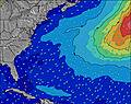 | 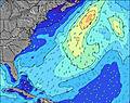 | 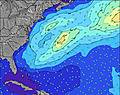 | 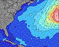 | 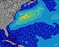 | 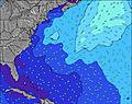 | 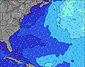 | ||||||||||||||
Wave Height (m) Direction Period (s) | S 6 | S 7 | S 7 | S 7 | S 7 | SSW 7 | SSW 6 | SSW 6 | SSE 6 | SSE 6 | SSE 6 | S 6 | S 5 | SE 7 | SSE 6 | SSE 7 | SSE 8 | SSE 9 | SE 8 | SE 8 | SE 7 |
Wave Graph | |||||||||||||||||||||
184 | 462 | 572 | 387 | 435 | 180 | 149 | 56 | 97 | 97 | 121 | 52 | 34 | 23 | 55 | 68 | 72 | 135 | 112 | 91 | 44 | |
Wind (km/h) | |||||||||||||||||||||
Wind State on-shore cross-onshore cross-shore cross-offshore off-shore glassy | on | cross-on | on | cross-on | cross-on | cross-on | cross-on | cross-on | on | on | on | on | on | on | on | cross-on | on | on | cross-on | on | on |
High Tide | 11:20AM0.73m | 11:32PM0.78m | 12:03PM0.76m | 00:13AM0.73m | 12:52PM0.79m | 00:59AM0.68m | 1:46PM0.82m | 1:52AM0.63m | 2:47PM0.85m | 2:54AM0.60m | 3:53PM0.88m | 4:02AM0.59m | 5:00PM0.92m | ||||||||
Low Tide | 5:35PM0.06m | 6:02AM0.02m | 6:24PM0.09m | 6:40AM0.02m | 7:19PM0.11m | 7:24AM0.01m | 8:22PM0.13m | 8:15AM0.01m | 9:31PM0.14m | 9:14AM0.01m | 10:43PM0.13m | 10:19AM-0.01m | 11:51PM0.10m | ||||||||
6:16 | — | — | 6:18 | — | — | 6:18 | — | — | 6:18 | — | — | 6:20 | — | — | 6:20 | — | — | 6:20 | — | — | |
— | 8:07 | — | — | 8:07 | — | — | 8:06 | — | — | 8:05 | — | — | 8:04 | — | — | 8:02 | — | — | 8:01 | — | |
mm | 6 | 8 | 13 | 25 | 13 | 14 | 15 | 6 | 8 | 5 | 2 | 1 | 5 | — | 3 | 1 | 1 | 1 | — | — | — |
Temp °C | 28 | 27 | 27 | 25 | 25 | 25 | 27 | 27 | 26 | 26 | 26 | 27 | 27 | 28 | 28 | 28 | 28 | 27 | 27 | 28 | 27 |
Feels °C | 28 | 26 | 26 | 24 | 24 | 25 | 28 | 27 | 27 | 28 | 28 | 30 | 30 | 30 | 30 | 31 | 31 | 29 | 31 | 30 | 28 |
Swell 1 Height (m) Direction Period (s) | E 6 | — | — | — | — | SE 7 | SSW 6 | SSW 6 | — | S 12 | S 12 | ESE 7 | SE 7 | SE 7 | E 10 | SSE 7 | SSE 8 | SSE 9 | SE 8 | SE 8 | SE 7 |
1 | — | — | — | — | 30 | 149 | 56 | — | 3 | 3 | 32 | 22 | 23 | 2 | 68 | 72 | 135 | 112 | 91 | 44 | |
Swell 2 Height (m) Direction Period (s) | — | — | — | — | — | — | SE 7 | SE 7 | — | E 10 | E 9 | E 13 | E 10 | E 10 | — | E 10 | E 9 | E 9 | E 9 | — | — |
— | — | — | — | — | — | 44 | 43 | — | 2 | 2 | 3 | 2 | 2 | — | 2 | 2 | 2 | 2 | — | — | |
Swell 3 Height (m) Direction Period (s) | — | — | — | — | — | — | — | — | — | — | — | E 9 | — | — | — | — | — | — | — | — | — |
— | — | — | — | — | — | — | — | — | — | — | 2 | — | — | — | — | — | — | — | — | — | |
Wind waves Height (m) Direction Period (s) | S 6 | S 7 | S 7 | S 7 | S 7 | SSW 7 | — | — | SSE 6 | SSE 6 | SSE 6 | S 6 | S 5 | SSW 5 | SSE 6 | SW 4 | — | — | — | — | S 4 |
184 | 462 | 572 | 387 | 435 | 180 | — | — | 97 | 97 | 121 | 52 | 34 | 20 | 55 | 3 | — | — | — | — | 6 | |
Nearest Offshore or Glassy | |||||||||||||||||||||
Distance (km) | 833 | 833 | 697 | 452 | 477 | 241 | 174 | 255 | 645 | 432 | 113 | 242 | 129 | 856 | 684 | 129 | 856 | 426 | 125 | 470 | 200 |
Best forecast wave conditions in North Carolina | |||||||||||||||||||||
Best forecast wave conditions in United States | |||||||||||||||||||||
Header Global | |||||||||||||||||||||
- Map Icons:
 Break
Break Live Wave Height (m)
 Live Wind Speed (km/h)
 Surf Rating (10 Max)
 Ocean Swells (m)
- Wind Speed (km/h)
Latest Updates


FREE! Surf-Forecast.com widget for your website
The surf report / weather widget below is available to embed on third party websites free of charge and provides a summary of our Atlantic Beach surf forecast. Simply grab the html code snippet that we provide and paste it into your own site. You can choose your preferred language and metric/imperial units for the surf forecast feed to suit users of your site. Click here to get the code.
Information about the Atlantic Beach Surf forecast
The above surf forecast table for Atlantic Beach provides essential information for determining whether the surfing conditions will be good over the next 16 days. A general guide to surfing at Atlantic Beach can be found by selecting the local surf guide option on the grey menu. Our Atlantic Beach surf forecast is unique since it includes wave energy (power) that defines the real feel of the surf rather than just the height or the period. If you surf the same spot (Atlantic Beach) regularly then make a mental note of the wave energy from the surf forecast table each time you go. Very soon you may start to choose your surf days based on the wave energy alone combined with our forecast of favourable offshore wind conditions. Our star ratings will help here and of course you will also find the usual wave height and period predictions on our surf forecasts as well as a full break down of the swell components under our advanced users option (to reveal that, click the little Einstein character under the tide times).
Further information to help with frequently asked questions about our surf forecast for Atlantic Beach may be found under the help tab on the top menu and also by moving your mouse over the question marks on the surf forecast table itself. Please always bear in mind that the forecast is for near-shore open water and local factors at each surf break influence the actual breaking wave height, such as the beach / reef profile, water depths offshore and shelter.
Atlantic Beach is 25 km (16 miles) from Havelock. If you plan a vacation in North Carolina, look for hotels and other accommodation in Havelock. Havelock has rooms for a wide range of budgets as well as car hire and transport links.
 Nearest