

Surf Forecasts:

Surf City Pier surf forecast from 3 Aug 2026:
- Best quality surf: Tuesday 4 Aug, 11AM (local time) - 3.5ft (1.0m), 7s period, S swell with cross-offshore winds.
- Most powerful swell: Tuesday 4 Aug, 5AM (local time) - 6ft (1.9m), 7s period, SSW swell with 394 kJ wave energy.
- Next surfable swell (1★+): Tuesday 4 Aug, 11AM (local time) - 3.5ft (1.0m), 7s period with S swell.
Best Forecast Surf Conditions for Surf City Pier this week:
The surf forecast for Surf City Pier over the next 16 days: The first swell (rated 1 star or higher) is forecast to arrive on Tuesday (Aug 04) at 11AM. The primary swell is predicted to be 1.0m and 7s period with a secondary swell of 0.4m and 8s. The wind is predicted to be cross-offshore as the swell arrives.
The most powerful waves expected at Surf City Pier in the next 16 days are 1.9m 7s and forecast to arrive on Tuesday (Aug 04) at 5AM. Winds are predicted to be cross-shore at the time the swell arrives.
| Wave Type | Time (EDT) & Date | Wave Height & Period |
|---|---|---|
| Next good surf (1 star+) | 11AM (Tue 4th Aug) | 3.5ft (1.0m) 7s |
| Best Surf | 11AM (Tue 4th Aug) | 3.5ft (1.0m) 7s |
| Most Powerful | 5AM (Tue 4th Aug) | 6ft (1.9m) 7s |
Table - best surf conditions forecast for Surf City Pier over the next 16 days.
The Lowdown
Alright, buckle up, ‘cause it’s a grim stretch ahead at Surf City Pier. The next two weeks are mostly a bust for decent paddle surfing. The swell energy is weak, the wind is trash, and the wave heights are tiny with terrible period.
That opening Monday, August 3rd, is a stormy, bumpy 3ft SE swell with a weak 7-second period and moderate cross-shore winds. The energy is only 194 – weak, and it’s got thunderstorms in the air. Monday afternoon pushes up to 6ft from the S, but still short period (7 sec) and onshore. The energy climbs to 306, but it’s messy and poor.
Tuesday, August 4th, is the best you’re gonna get in this whole outlook, and it’s still nothing special. Morning shows a 3ft S swell, 7-second period, with a light WSW cross-offshore breeze. The combined energy is only 101 – barely moderate. The report says “clean” conditions, which is a big win for this spot. The waves are small and weak, but it’s the cleanest window in the whole 16 days. For a beginner-friendly break like this, it’s surfable, but barely. The afternoon goes cross-shore and the swell drops.
From Wednesday, August 5th, right through to August 18th, it’s a grim mix of onshore winds, tiny swell (mostly under 3ft), and short periods of 4 to 8 seconds. The combined energy stays below 100 for most of it, often in the 20s, 30s, 40s, and 50s – that’s flat, weak energy. There are a few mornings with a clean-looking wind, like on the 12th and 13th, but the swell is laughably small – 1ft on the 12th, 2ft on the 13th. You’d be scraping your fins.
Sunday, August 9th, morning goes glassy with a 2ft SE swell, 7-second period, and calm wind. The waves are marginal, but at least it’s flat calm. The energy is only 52. It’s “surfable but very ordinary.” The rest of the week is a write-off.
The one date that stands out, and it’s a stretch, is Tuesday, August 4th, in the morning. That’s the only window where the wind is offshore and clean. The swell is small, but it’s the only clean, surfable wave in the whole 16 days. For a beginner break, that’s your shot.
Water temp? Not given, but for August, it’s about average for the time of year.
This is a tough one. For a very consistent break like Surf City Pier, it’s unusual to see such a long stretch of poor conditions. But it happens. The good news is, it’s consistent, so when the swell and wind line up, it fires – but that ain’t happening in this window. If you’re desperate, paddle out Tuesday morning for a few weak, clean ones. Otherwise, it’s a long wait.
Rusty.
Short Range ForecastHeavy rain (total 51mm), heaviest during Sun night. Warm (max 28°C on Wed afternoon, min 24°C on Mon night). Wind will be generally light. | Days 5-7 Weather SummaryLight rain (total 6mm), mostly falling on Wed night. Warm (max 30°C on Thu afternoon, min 25°C on Sat afternoon). Wind will be generally light. | ||||||||||||||||||
Monday 3 | Tuesday 4 | Wednesday 5 | Thursday 6 | Friday 7 | Saturday 8 | ||||||||||||||
Night | AM | PM | Night | AM | PM | Night | AM | PM | Night | AM | PM | Night | AM | PM | Night | AM | PM | Night | |
Swell Height Map |  | 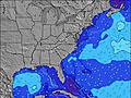 | 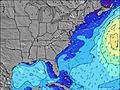 | 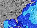 | 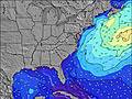 | 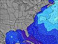 | 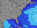 | ||||||||||||
Wave Height (m) Direction Period (s) | S 7 | SE 7 | S 7 | S 7 | S 7 | SSW 6 | SE 6 | SSE 6 | SE 6 | SSE 6 | SSE 6 | ESE 7 | SE 6 | SE 6 | SE 7 | SE 8 | SE 8 | SE 8 | SE 8 |
Wave Graph | |||||||||||||||||||
352 | 104 | 306 | 389 | 86 | 160 | 56 | 88 | 56 | 75 | 57 | 31 | 39 | 38 | 54 | 91 | 90 | 88 | 67 | |
Wind (km/h) | |||||||||||||||||||
Wind State on-shore cross-onshore cross-shore cross-offshore off-shore glassy | cross | cross | cross | cross | cross-off | cross | cross-on | cross-on | cross-on | cross-on | cross-on | cross-on | cross-on | cross-on | cross-on | cross-on | cross-on | cross-on | glassy |
High Tide | 10:47PM1.38m | 11:18AM1.34m | 11:28PM1.30m | 12:07PM1.40m | 00:14AM1.21m | 1:01PM1.46m | 1:07AM1.12m | 2:02PM1.51m | 2:09AM1.07m | 3:08PM1.57m | 3:17AM1.05m | 4:15PM1.64m | 4:27AM1.08m | ||||||
Low Tide | 4:59AM0.03m | 5:21PM0.14m | 5:37AM0.02m | 6:16PM0.18m | 6:21AM0.02m | 7:19PM0.21m | 7:12AM0.02m | 8:28PM0.23m | 8:11AM0.01m | 9:40PM0.21m | 9:16AM-0.02m | 10:48PM0.16m | |||||||
— | 6:20 | — | — | 6:22 | — | — | 6:22 | — | — | 6:24 | — | — | 6:24 | — | — | 6:24 | — | — | |
8:10 | — | 8:09 | — | — | 8:08 | — | — | 8:07 | — | — | 8:07 | — | — | 8:06 | — | — | 8:05 | — | |
mm | 10 | 9 | 5 | 7 | 10 | 3 | 4 | 2 | 1 | 3 | 2 | — | — | — | — | — | — | 1 | 3 |
Temp °C | 27 | 25 | 27 | 27 | 25 | 25 | 26 | 27 | 28 | 27 | 28 | 30 | 27 | 29 | 30 | 27 | 28 | 28 | 25 |
Feels °C | 27 | 26 | 29 | 28 | 28 | 28 | 28 | 30 | 30 | 30 | 32 | 32 | 30 | 33 | 32 | 30 | 31 | 30 | 28 |
Swell 1 Height (m) Direction Period (s) | — | SE 7 | — | — | S 7 | S 6 | SE 6 | — | SE 6 | — | — | ESE 7 | E 10 | SE 6 | SE 7 | SE 8 | SE 8 | SE 8 | SE 8 |
— | 104 | — | — | 86 | 92 | 56 | — | 56 | — | — | 31 | 2 | 38 | 54 | 91 | 90 | 88 | 67 | |
Swell 2 Height (m) Direction Period (s) | — | — | — | — | SE 8 | SE 7 | — | — | — | E 12 | E 10 | E 10 | E 11 | E 9 | E 9 | E 9 | — | — | — |
— | — | — | — | 15 | 31 | — | — | — | 3 | 2 | 2 | 2 | 2 | 2 | 2 | — | — | — | |
Swell 3 Height (m) Direction Period (s) | — | — | — | — | — | — | — | — | — | — | — | — | — | — | — | — | — | — | — |
— | — | — | — | — | — | — | — | — | — | — | — | — | — | — | — | — | — | — | |
Wind waves Height (m) Direction Period (s) | S 7 | SSW 6 | S 7 | S 7 | — | SSW 6 | SSW 6 | SSE 6 | S 6 | SSE 6 | SSE 6 | S 5 | SE 6 | SW 4 | SSW 3 | — | — | — | S 4 |
352 | 90 | 306 | 389 | — | 160 | 33 | 88 | 23 | 75 | 57 | 26 | 39 | 3 | 4 | — | — | — | 9 | |
Nearest Offshore or Glassy | |||||||||||||||||||
Distance (km) | 573 | 616 | 727 | 299 | 0 | 36 | 311 | 36 | 54 | 588 | 54 | 920 | 740 | 714 | 920 | 525 | 54 | 531 | 0 |
Best forecast wave conditions in North Carolina | |||||||||||||||||||
Best forecast wave conditions in United States | |||||||||||||||||||
Header Global | |||||||||||||||||||
- Map Icons:
 Break
Break Live Wave Height (m)
 Live Wind Speed (km/h)
 Surf Rating (10 Max)
 Ocean Swells (m)
- Wind Speed (km/h)
Latest Updates


FREE! Surf-Forecast.com widget for your website
The surf report / weather widget below is available to embed on third party websites free of charge and provides a summary of our Surf City Pier surf forecast. Simply grab the html code snippet that we provide and paste it into your own site. You can choose your preferred language and metric/imperial units for the surf forecast feed to suit users of your site. Click here to get the code.
Information about the Surf City Pier Surf forecast
The above surf forecast table for Surf City Pier provides essential information for determining whether the surfing conditions will be good over the next 16 days. A general guide to surfing at Surf City Pier can be found by selecting the local surf guide option on the grey menu. Our Surf City Pier surf forecast is unique since it includes wave energy (power) that defines the real feel of the surf rather than just the height or the period. If you surf the same spot (Surf City Pier) regularly then make a mental note of the wave energy from the surf forecast table each time you go. Very soon you may start to choose your surf days based on the wave energy alone combined with our forecast of favourable offshore wind conditions. Our star ratings will help here and of course you will also find the usual wave height and period predictions on our surf forecasts as well as a full break down of the swell components under our advanced users option (to reveal that, click the little Einstein character under the tide times).
Further information to help with frequently asked questions about our surf forecast for Surf City Pier may be found under the help tab on the top menu and also by moving your mouse over the question marks on the surf forecast table itself. Please always bear in mind that the forecast is for near-shore open water and local factors at each surf break influence the actual breaking wave height, such as the beach / reef profile, water depths offshore and shelter.
Surf City Pier is 37 km (23 miles) from the city of Wilmington. If you plan a vacation in North Carolina, look for hotels and other accommodation in Wilmington. Wilmington has rooms for a wide range of budgets as well as car hire and transport links.
 Nearest