

Surf Forecasts:

Road K surf forecast from 3 Aug 2026:
- Best quality surf: Monday 3 Aug, 11PM (local time) - 6.5ft (2.0m), 8s period, S swell with offshore winds.
- Most powerful swell: Monday 3 Aug, 8PM (local time) - 8ft (2.5m), 9s period, S swell with 955 kJ wave energy.
- Next surfable swell (1★+): Monday 3 Aug, 11PM (local time) - 6.5ft (2.0m), 8s period with S swell.
Best Forecast Surf Conditions for Road K this week:
The surf forecast for Road K over the next 16 days: The first swell (rated 1 star or higher) is forecast to arrive on Monday (Aug 03) at 11PM. The primary swell is predicted to be 2.0m and 8s period. The wind is predicted to be offshore as the swell arrives.
The most powerful waves expected at Road K in the next 16 days are 2.5m 9s and forecast to arrive on Monday (Aug 03) at 8PM. Winds are predicted to be cross-offshore at the time the swell arrives. The largest open ocean swell (not directed at the beach) is 0.4m 3s period and expected on Monday (Aug 03) at 11PM.
| Wave Type | Time (EDT) & Date | Wave Height & Period |
|---|---|---|
| Next good surf (1 star+) | 11PM (Mon 3rd Aug) | 6.5ft (2.0m) 8s |
| Best Surf | 11PM (Mon 3rd Aug) | 6.5ft (2.0m) 8s |
| Most Powerful | 8PM (Mon 3rd Aug) | 8ft (2.5m) 9s |
Table - best surf conditions forecast for Road K over the next 16 days.
The Lowdown
Alright, Rusty here. Let’s break down the outlook for Road K. We’re looking at a long, hard wait before the surf finally shows up. For the first two weeks, it’s mostly a waste of time with blown-out, gutless conditions.
The pattern is ugly. The wind is almost always cross or onshore, and the swell is small, weak, and short-period. The combined energy is mostly in the double digits (80-90, 60-70), and even the higher readings like 824 on August 3rd come with a stormy 25 mph cross-onshore wind that makes it a kite-surfing day, not a surf day. The water temp is 72°F, which is dead average for this time of year.
The biggest thing to know is the gap. There is nothing worth paddling for from now until the morning of Monday, August 18th. That’s a solid two-week stretch of nothing.
Monday, August 18th is the only real standout. The morning is the best of the whole 16 days. We get a clean, gentle offshore wind from the north, and a 6 ft swell from the southwest. The combined energy is a moderate 230, and while the period is a short 6 seconds, that offshore wind will clean it up nicely. The swell direction is a good fit for what this sandbar likes. It’s not a big day, but after two weeks of nothing, it’s a welcome sight. The afternoon has a 6 ft swell from the SSW with a clean cross-off breeze, but it’s a bit more marginal.
The rest of the second week is still pretty average. The little bumps on the 13th, 14th, and 16th all have cross or cross-onshore winds, so the quality will be poor.
Bottom line: forget the next two weeks. Circle Monday, August 18th morning on your calendar. That’s your only real shot.
Rusty.
Short Range ForecastModerate rain (total 16mm), heaviest on Mon morning. Warm (max 26°C on Mon night, min 20°C on Tue morning). Winds decreasing (strong winds from the SSW on Mon afternoon, light winds from the NE by Tue morning). | Days 4-6 Weather SummaryLight rain (total 6mm), mostly falling on Sat afternoon. Warm (max 29°C on Fri afternoon, min 25°C on Thu morning). Wind will be generally light. | ||||||||||||||||||||
Monday 3 | Tuesday 4 | Wednesday 5 | Thursday 6 | Friday 7 | Saturday 8 | Sunday 9 | |||||||||||||||
AM | PM | Night | AM | PM | Night | AM | PM | Night | AM | PM | Night | AM | PM | Night | AM | PM | Night | AM | PM | Night | |
Swell Height Map | 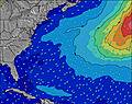 | 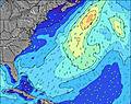 | 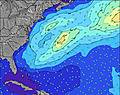 | 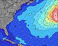 | 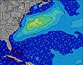 | 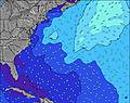 | 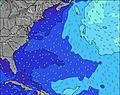 | ||||||||||||||
Wave Height (m) Direction Period (s) | S 8 | S 9 | S 8 | S 8 | S 8 | S 8 | SSE 7 | SSE 7 | SE 7 | S 6 | S 6 | SW 6 | S 6 | SSW 6 | SSW 6 | SSW 6 | SSW 6 | SSW 6 | SSW 6 | SSW 6 | SSW 6 |
Wave Graph | |||||||||||||||||||||
824 | 769 | 401 | 142 | 90 | 76 | 153 | 82 | 40 | 73 | 104 | 109 | 78 | 64 | 48 | 34 | 37 | 84 | 57 | 61 | 100 | |
Wind (km/h) | |||||||||||||||||||||
Wind State on-shore cross-onshore cross-shore cross-offshore off-shore glassy | cross-on | cross-on | off | cross-off | cross-on | cross-off | cross-off | cross-on | cross | cross-on | cross-on | cross | cross | cross-on | cross | cross | cross-on | cross-on | cross | cross-on | cross |
High Tide | 11:36AM1.02m | 11:51PM0.96m | 12:23PM1.03m | 00:40AM0.91m | 1:17PM1.03m | 1:36AM0.86m | 2:16PM1.04m | 2:42AM0.83m | 3:21PM1.06m | 3:50AM0.83m | 4:25PM1.11m | 4:56AM0.87m | 5:26PM1.16m | ||||||||
Low Tide | 5:06PM0.09m | 5:26AM0.03m | 5:58PM0.12m | 6:14AM0.04m | 6:55PM0.15m | 7:07AM0.06m | 7:57PM0.17m | 8:05AM0.09m | 9:04PM0.17m | 9:07AM0.09m | 10:16PM0.16m | 10:14AM0.09m | 11:29PM0.11m | ||||||||
5:47 | — | — | 5:48 | — | — | 5:48 | — | — | 5:50 | — | — | 5:50 | — | — | 5:52 | — | — | 5:52 | — | — | |
— | 8:04 | — | — | 8:01 | — | — | 8:00 | — | — | 8:00 | — | — | 7:59 | — | — | 7:58 | — | — | 7:55 | — | |
mm | 7 | 6 | 3 | — | — | — | — | — | — | 1 | — | — | — | — | — | — | 2 | 3 | — | — | — |
Temp °C | 25 | 25 | 26 | 22 | 23 | 23 | 22 | 24 | 25 | 26 | 26 | 26 | 27 | 29 | 29 | 26 | 28 | 26 | 27 | 29 | 27 |
Feels °C | 23 | 24 | 25 | 22 | 22 | 22 | 23 | 25 | 27 | 27 | 26 | 26 | 29 | 30 | 29 | 28 | 28 | 26 | 29 | 27 | 26 |
Swell 1 Height (m) Direction Period (s) | — | — | S 8 | S 8 | S 8 | S 8 | SSE 7 | SSE 7 | SE 7 | E 10 | SE 7 | S 7 | S 6 | SSW 6 | SE 8 | SSW 6 | SE 8 | SSW 6 | SSW 6 | E 8 | SSW 6 |
— | — | 401 | 142 | 90 | 76 | 153 | 82 | 27 | 2 | 8 | 92 | 78 | 64 | 16 | 34 | 22 | 48 | 45 | 1 | 100 | |
Swell 2 Height (m) Direction Period (s) | — | — | — | SE 7 | SE 7 | SE 7 | E 12 | — | E 10 | — | E 10 | E 11 | SE 8 | SE 8 | E 9 | SE 8 | E 9 | SE 7 | SE 7 | E 11 | SE 10 |
— | — | — | 30 | 37 | 45 | 3 | — | 2 | — | 2 | 2 | 9 | 14 | 2 | 31 | 1 | 14 | 8 | 2 | 4 | |
Swell 3 Height (m) Direction Period (s) | — | — | — | — | — | E 12 | E 12 | E 10 | — | — | — | E 11 | E 10 | E 9 | — | E 8 | — | E 9 | E 8 | — | E 9 |
— | — | — | — | — | 3 | 3 | 2 | — | — | — | 2 | 2 | 2 | — | 1 | — | 1 | 1 | — | 2 | |
Wind waves Height (m) Direction Period (s) | S 8 | S 9 | — | — | — | — | NNW 2 | SSW 2 | SSW 6 | S 6 | S 6 | SW 6 | — | — | SSW 6 | — | SSW 6 | SSW 6 | SSW 6 | SSW 6 | — |
824 | 769 | — | — | — | — | 1 | 1 | 40 | 73 | 104 | 109 | — | — | 48 | — | 37 | 84 | 57 | 61 | — | |
Nearest Offshore or Glassy | |||||||||||||||||||||
Distance (km) | 317 | 117 | 0 | 0 | 84 | 14 | 0 | 59 | 31 | 59 | 84 | 84 | 31 | 141 | 76 | 3 | 317 | 17 | 43 | 136 | 260 |
Best forecast wave conditions in Long Island New York | |||||||||||||||||||||
Best forecast wave conditions in United States | |||||||||||||||||||||
Header Global | |||||||||||||||||||||
- Map Icons:
 Break
Break Live Wave Height (m)
 Live Wind Speed (km/h)
 Surf Rating (10 Max)
 Ocean Swells (m)
- Wind Speed (km/h)
Latest Updates


FREE! Surf-Forecast.com widget for your website
The surf report / weather widget below is available to embed on third party websites free of charge and provides a summary of our Road K surf forecast. Simply grab the html code snippet that we provide and paste it into your own site. You can choose your preferred language and metric/imperial units for the surf forecast feed to suit users of your site. Click here to get the code.
Information about the Road K Surf forecast
The above surf forecast table for Road K provides essential information for determining whether the surfing conditions will be good over the next 16 days. A general guide to surfing at Road K can be found by selecting the local surf guide option on the grey menu. Our Road K surf forecast is unique since it includes wave energy (power) that defines the real feel of the surf rather than just the height or the period. If you surf the same spot (Road K) regularly then make a mental note of the wave energy from the surf forecast table each time you go. Very soon you may start to choose your surf days based on the wave energy alone combined with our forecast of favourable offshore wind conditions. Our star ratings will help here and of course you will also find the usual wave height and period predictions on our surf forecasts as well as a full break down of the swell components under our advanced users option (to reveal that, click the little Einstein character under the tide times).
Further information to help with frequently asked questions about our surf forecast for Road K may be found under the help tab on the top menu and also by moving your mouse over the question marks on the surf forecast table itself. Please always bear in mind that the forecast is for near-shore open water and local factors at each surf break influence the actual breaking wave height, such as the beach / reef profile, water depths offshore and shelter.
Road K is 28 km (17 miles) from Mastic. If you plan a vacation in Long Island New York, look for hotels and other accommodation in Mastic. Mastic has rooms for a wide range of budgets as well as car hire and transport links.
 Nearest