

Surf Forecasts:

Robert Moses State Park surf forecast from 15 Jul 2026:
- Best quality surf: Thursday 16 Jul, 8PM (local time) - 3ft (0.9m), 5s period, SSW swell with offshore winds.
- Most powerful swell: Monday 20 Jul, 5PM (local time) - 4.5ft (1.3m), 9s period, S swell with 262 kJ wave energy.
- Next surfable swell (1★+): Thursday 16 Jul, 8PM (local time) - 3ft (0.9m), 5s period with SSW swell.
Best Forecast Surf Conditions for Robert Moses State Park this week:
The surf forecast for Robert Moses State Park over the next 16 days: The first swell (rated 1 star or higher) is forecast to arrive on Thursday (Jul 16) at 8PM. The primary swell is predicted to be 0.9m and 5s period with a secondary swell of 0.1m and 9s. The wind is predicted to be offshore as the swell arrives.
The most powerful waves expected at Robert Moses State Park in the next 16 days are 1.3m 9s and forecast to arrive on Monday (Jul 20) at 5PM. Winds are predicted to be cross-onshore at the time the swell arrives. The largest open ocean swell (not directed at the beach) is 0.8m 4s period and expected on Sunday (Jul 19) at 11AM.
| Wave Type | Time (EDT) & Date | Wave Height & Period |
|---|---|---|
| Next good surf (1 star+) | 8PM (Thu 16th Jul) | 3ft (0.9m) 5s |
| Best Surf | 8PM (Thu 16th Jul) | 3ft (0.9m) 5s |
| Most Powerful | 5PM (Mon 20th Jul) | 4.5ft (1.3m) 9s |
Table - best surf conditions forecast for Robert Moses State Park over the next 16 days.
The Lowdown
Alright, let’s break it down.
First off, Robert Moses State Park is looking pretty flat for the next 16 days. There’s a long stretch from now through mid-July with almost nothing rideable. We’re talking a big gap of no surf for most of the forecast, with just a couple of very ordinary moments at the very tail end.
Wednesday afternoon, July 15th, we see a tiny 3ft swell from the SW, but the period is a short 5 seconds, and combined wave energy is weak (56). It’s clean with a cross-off NW breeze at 12 mph, but it’s just too small to get excited about. Water temp is 73°, about a touch warmer than normal for this time of year.
Thursday and Friday, July 16th and 17th, bring even smaller surf, around 2ft to 2ft, with cross-shore and glassy conditions, but no power behind it – energy readings are 32 and 26. Not worth suiting up.
Saturday, July 18th, stays tiny with light rain and onshore winds.
The first real glimmer comes Sunday morning, July 19th. Swell picks to 5ft from the south, period bumping to 7 seconds, combined energy jumps to 196 – that’s moderate. Winds are cross-off from the WNW at 15 mph, so it should be clean. But it’s still rated poor. Sunday afternoon stays similar at 4ft, still cross-off, energy 169. Best of the week, but still just average.
Monday morning, July 20th, is listed as “marginal” – 4ft south swell, period 9 seconds, energy 204, light cross-shore wind. That’s a small step up, but still not worth calling in sick. The afternoon turns onshore and choppy.
After that, it’s a long run of poor conditions with onshore winds and small, weak swell through the 21st to the 26th. A few clean moments pop up on the 22nd morning with a cross-off NE breeze and 3ft SSE swell (energy 79), but it’s just “surfable but ordinary.”
The real standout? If you’re desperate, Tuesday, July 28th, morning. That’s 2ft from the ESE, glassy and clean with a light offshore NNW breeze at 9 mph, and it gets a “surfable but very ordinary” note. Energy is pitiful at 53, but for this stretch, that’s as good as it gets. It’ll be tiny, clean, and probably uncrowded – you’ll want a longboard or a foil.
Bottom line: there’s almost nothing worth chasing for the next two weeks. A few clean mornings with knee-high dribble. Keep an eye on the charts, because it usually doesn’t stay this quiet for long around here.
Rusty
Short Range ForecastLight rain (total 3mm), mostly falling on Sat morning. Warm (max 36°C on Wed afternoon, min 20°C on Sat morning). Wind will be generally light. | Days 5-7 Weather SummaryModerate rain (total 14mm), heaviest on Sat afternoon. Warm (max 27°C on Sun afternoon, min 21°C on Sat afternoon). Winds decreasing (fresh winds from the W on Sun morning, calm by Mon morning). | ||||||||||||||||||||
Wed 15 | Thursday 16 | Friday 17 | Saturday 18 | Sunday 19 | Monday 20 | Tuesday 21 | |||||||||||||||
PM | Night | AM | PM | Night | AM | PM | Night | AM | PM | Night | AM | PM | Night | AM | PM | Night | AM | PM | Night | AM | |
Swell Height Map | 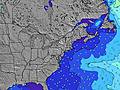 | 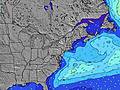 | 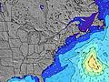 | 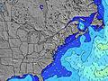 | 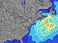 | 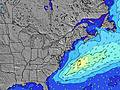 | 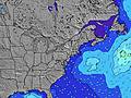 | 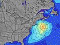 | |||||||||||||
Wave Height (m) Direction Period (s) | SW 5 | S 6 | S 6 | SSW 5 | S 5 | S 6 | S 6 | S 5 | SSW 5 | ESE 4 | S 6 | S 7 | S 8 | S 8 | S 9 | S 9 | S 8 | S 8 | S 8 | S 7 | SSE 7 |
Wave Graph | |||||||||||||||||||||
39 | 15 | 16 | 64 | 29 | 15 | 22 | 20 | 8 | 13 | 146 | 189 | 163 | 169 | 198 | 262 | 181 | 114 | 110 | 113 | 77 | |
Wind (km/h) | |||||||||||||||||||||
Wind State on-shore cross-onshore cross-shore cross-offshore off-shore glassy | cross-off | off | cross | cross-on | cross-off | glassy | cross-on | cross-on | cross-on | cross-on | cross | cross-off | cross-off | off | cross | cross-on | cross-on | on | on | cross-off | cross-off |
High Tide | 8:53PM1.67m | 9:32AM1.42m | 9:44PM1.60m | 10:26AM1.42m | 10:37PM1.51m | 11:20AM1.41m | 11:28PM1.41m | 12:11PM1.39m | 00:19AM1.30m | 1:00PM1.37m | 1:09AM1.19m | 1:48PM1.34m | 1:59AM1.11m | ||||||||
Low Tide | 2:37PM-0.09m | 3:24AM-0.20m | 3:29PM-0.06m | 4:10AM-0.18m | 4:19PM-0.01m | 4:55AM-0.12m | 5:10PM0.07m | 5:40AM-0.03m | 6:02PM0.16m | 6:26AM0.06m | 7:00PM0.24m | 7:16AM0.15m | 8:03PM0.28m | 8:09AM0.22m | |||||||
— | — | 5:35 | — | — | 5:35 | — | — | 5:37 | — | — | 5:37 | — | — | 5:37 | — | — | 5:39 | — | — | 5:39 | |
8:22 | — | — | 8:22 | — | — | 8:21 | — | — | 8:21 | — | — | 8:20 | — | — | 8:19 | — | — | 8:17 | — | 8:17 | |
mm | — | — | — | — | — | — | — | — | 3 | 5 | 6 | — | — | — | — | — | — | 3 | 9 | 5 | — |
Temp °C | 36 | 33 | 29 | 31 | 31 | 26 | 27 | 24 | 23 | 21 | 23 | 25 | 27 | 26 | 23 | 25 | 24 | 24 | 25 | 25 | 23 |
Feels °C | 33 | 30 | 26 | 27 | 29 | 25 | 25 | 21 | 22 | 19 | 25 | 23 | 24 | 22 | 21 | 22 | 22 | 24 | 28 | 27 | 22 |
Swell 1 Height (m) Direction Period (s) | SW 5 | S 6 | S 6 | SE 9 | S 5 | S 6 | SE 8 | SE 8 | SSW 5 | S 5 | SE 13 | S 7 | S 8 | S 8 | S 9 | SE 12 | SE 12 | E 12 | SE 7 | S 7 | SSE 7 |
39 | 15 | 16 | 3 | 29 | 15 | 3 | 3 | 8 | 2 | 7 | 189 | 163 | 169 | 198 | 6 | 6 | 3 | 12 | 113 | 77 | |
Swell 2 Height (m) Direction Period (s) | SE 9 | NNW 3 | ESE 8 | SE 15 | SE 9 | SE 9 | SE 14 | SE 14 | SE 4 | SE 13 | SE 13 | SE 13 | SE 13 | SE 12 | SE 12 | SE 12 | SE 12 | SE 7 | S 10 | E 11 | S 9 |
12 | 1 | 7 | 9 | 3 | 3 | 8 | 8 | 2 | 7 | 7 | 7 | 6 | 6 | 6 | 6 | 6 | 25 | 7 | 2 | 2 | |
Swell 3 Height (m) Direction Period (s) | S 17 | ESE 9 | SE 15 | — | SE 15 | SE 15 | — | E 9 | SE 8 | — | E 8 | — | — | — | — | — | — | SE 12 | SE 12 | — | — |
5 | 7 | 9 | — | 9 | 8 | — | 2 | 3 | — | 1 | — | — | — | — | — | — | 6 | 5 | — | — | |
Wind waves Height (m) Direction Period (s) | — | — | WSW 3 | SSW 5 | NW 3 | — | S 6 | S 5 | — | ESE 4 | S 6 | W 4 | WNW 4 | NW 3 | — | S 9 | S 8 | S 8 | S 8 | — | — |
— | — | 3 | 64 | 2 | — | 22 | 20 | — | 13 | 146 | 21 | 15 | 3 | — | 262 | 181 | 114 | 110 | — | — | |
Nearest Offshore or Glassy | |||||||||||||||||||||
Distance (km) | 50 | 103 | 1723 | 1606 | 67 | 793 | 785 | 1231 | 785 | 199 | 273 | 74 | 35 | 0 | 26 | 127 | 66 | 149 | 47 | 4 | 0 |
Best forecast wave conditions in Long Island New York | |||||||||||||||||||||
Best forecast wave conditions in United States | |||||||||||||||||||||
Header Global | |||||||||||||||||||||
- Map Icons:
 Break
Break Live Wave Height (m)
 Live Wind Speed (km/h)
 Surf Rating (10 Max)
 Ocean Swells (m)
- Wind Speed (km/h)


FREE! Surf-Forecast.com widget for your website
The surf report / weather widget below is available to embed on third party websites free of charge and provides a summary of our Robert Moses State Park surf forecast. Simply grab the html code snippet that we provide and paste it into your own site. You can choose your preferred language and metric/imperial units for the surf forecast feed to suit users of your site. Click here to get the code.
Information about the Robert Moses State Park Surf forecast
The above surf forecast table for Robert Moses State Park provides essential information for determining whether the surfing conditions will be good over the next 16 days. A general guide to surfing at Robert Moses State Park can be found by selecting the local surf guide option on the grey menu. Our Robert Moses State Park surf forecast is unique since it includes wave energy (power) that defines the real feel of the surf rather than just the height or the period. If you surf the same spot (Robert Moses State Park) regularly then make a mental note of the wave energy from the surf forecast table each time you go. Very soon you may start to choose your surf days based on the wave energy alone combined with our forecast of favourable offshore wind conditions. Our star ratings will help here and of course you will also find the usual wave height and period predictions on our surf forecasts as well as a full break down of the swell components under our advanced users option (to reveal that, click the little Einstein character under the tide times).
Further information to help with frequently asked questions about our surf forecast for Robert Moses State Park may be found under the help tab on the top menu and also by moving your mouse over the question marks on the surf forecast table itself. Please always bear in mind that the forecast is for near-shore open water and local factors at each surf break influence the actual breaking wave height, such as the beach / reef profile, water depths offshore and shelter.
Robert Moses State Park is 10 km (6 miles) from West Islip. If you plan a vacation in Long Island New York, look for hotels and other accommodation in West Islip. West Islip has rooms for a wide range of budgets as well as car hire and transport links.
 Nearest