

Surf Forecasts:

Panic Point (Weekapaug) surf forecast from 25 Jul 2026:
- Most powerful swell: Wednesday 29 Jul, 11PM (local time) - 6.5ft (2.0m), 7s period, E swell with 353 kJ wave energy.
Best Forecast Surf Conditions for Panic Point (Weekapaug) this week:
The most powerful waves expected at Panic Point (Weekapaug) in the next 16 days are 2.0m 7s and forecast to arrive on Wednesday (Jul 29) at 11PM. Winds are predicted to be cross-shore at the time the swell arrives. The largest open ocean swell (not directed at the beach) is 1.2m 5s period and expected on Wednesday (Jul 29) at 11AM.
| Wave Type | Time (EDT) & Date | Wave Height & Period |
|---|---|---|
| Next good surf (1 star+) | - | - |
| Best Surf | - | - |
| Most Powerful | 11PM (Wed 29th Jul) | 6.5ft (2.0m) 7s |
Table - best surf conditions forecast for Panic Point (Weekapaug) over the next 16 days.
The Lowdown
Alright folks, Rusty here. Let's take a look at what's cooking for our little corner of the coast.
To be straight with you, the next couple of weeks are looking pretty slim. We’ve got a long stretch of small, weak energy with a lot of onshore chop, so don't get your hopes up for any hero sessions. The first real glimmer of something surfable doesn't show up until the very end of July and into early August.
The main spot we’re looking at is Panic Point (Weekapaug). It’s a point break that’s usually pretty inconsistent, so when it does get a pulse, it’s worth keeping an eye on. Water temps are sitting right around average for this time of year, so nothing wild there.
The first week is a write-off. From Saturday the 25th right through to the end of the month, we’re looking at tiny, weak waves with the combined energy barely cracking triple digits. The wind is mostly cross or cross-onshore, making for a choppy, messy ocean. There’s a brief moment on Monday the 27th where the wind goes glassy in the morning, but the swell is still a pathetic 2 ft from the ESE. It’s a tease, not a session.
The only time this place starts to look half-interesting is on Sunday the 2nd of August. We see a bump in the combined energy to 134 (moderate) with a 4 ft swell from the south. The wind is clean, cross-off. It’s still not a pumping day, but it’s the first time the forecast mentions "surfable waves." Monday the 3rd of August looks similar, with a 4 ft south swell and better offshore winds in the afternoon, delivering a combined energy of 215 (moderate). The period is a slow 9 seconds, so it’s not a groundswell, but it’s the best we’ve got on offer.
Beyond that, the second week trails off again into tiny, weak swells. Thursday the 6th has a clean 4 ft morning, but the energy is low. Don’t plan a trip around it.
Honestly, if you’re desperate for a paddle, the late morning of Monday the 3rd of August is your best bet. It’s not a standout, but it’s the only time the stars sort of align with a little south swell and clean offshore wind. The swell direction isn't perfect for the point's optimum (SE), but it’s the cleanest we’ll see.
For the rest of the time, with such small, weak surf and breezy conditions, this setup looks more interesting for kite surfing than paddle surfing. It’s a dry spell, lads.
Rusty.
Short Range ForecastMostly dry. Warm (max 23°C on Sat afternoon, min 14°C on Sun night). Wind will be generally light. | Days 5-7 Weather SummaryHeavy rain (total 27mm), heaviest during Wed morning. Warm (max 23°C on Tue morning, min 18°C on Thu morning). Wind will be generally light. | ||||||||||||||||||
Saturday 25 | Sunday 26 | Monday 27 | Tuesday 28 | Wednesday 29 | Thursday 30 | ||||||||||||||
Night | AM | PM | Night | AM | PM | Night | AM | PM | Night | AM | PM | Night | AM | PM | Night | AM | PM | Night | |
Swell Height Map |  |  |  |  | 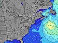 | 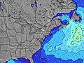 | 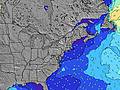 | ||||||||||||
Wave Height (m) Direction Period (s) | SE 8 | ESE 7 | ESE 7 | ESE 7 | E 7 | ESE 7 | SE 7 | ESE 7 | SE 7 | SE 7 | SE 7 | SE 7 | SSE 5 | SSE 8 | SE 6 | ESE 7 | S 8 | SSE 9 | S 10 |
Wave Graph | |||||||||||||||||||
45 | 91 | 78 | 81 | 112 | 70 | 56 | 36 | 41 | 32 | 42 | 27 | 23 | 22 | 167 | 178 | 173 | 206 | 184 | |
Wind (km/h) | |||||||||||||||||||
Wind State on-shore cross-onshore cross-shore cross-offshore off-shore glassy | glassy | cross-on | cross | on | cross-on | cross | on | glassy | off | off | cross-off | cross-off | cross-off | cross-off | cross | on | cross-on | cross | cross |
High Tide | 6:15AM0.59m | 6:44PM0.84m | 7:06AM0.61m | 7:28PM0.86m | 7:48AM0.63m | 8:04PM0.87m | 8:23AM0.65m | 8:36PM0.87m | 8:55AM0.67m | 9:04PM0.87m | 9:27AM0.70m | 9:34PM0.87m | |||||||
Low Tide | 00:32AM0.14m | 12:18PM0.12m | 1:20AM0.12m | 1:05PM0.11m | 2:00AM0.09m | 1:45PM0.10m | 2:35AM0.08m | 2:19PM0.09m | 3:08AM0.06m | 2:48PM0.09m | 3:39AM0.05m | 3:15PM0.09m | 4:08AM0.03m | ||||||
— | 5:35 | — | — | 5:35 | — | — | 5:37 | — | — | 5:37 | — | — | 5:39 | — | — | 5:39 | — | — | |
8:10 | — | 8:09 | — | — | 8:09 | — | — | 8:08 | — | — | 8:07 | — | — | 8:07 | — | — | 8:05 | — | |
mm | — | — | — | — | — | — | — | — | — | — | — | — | 5 | 12 | 6 | 3 | 1 | — | — |
Temp °C | 21 | 21 | 23 | 20 | 22 | 23 | 20 | 20 | 22 | 20 | 23 | 23 | 21 | 20 | 21 | 21 | 18 | 23 | 21 |
Feels °C | 19 | 18 | 20 | 18 | 19 | 20 | 19 | 20 | 21 | 19 | 22 | 21 | 21 | 19 | 20 | 22 | 17 | 22 | 20 |
Swell 1 Height (m) Direction Period (s) | SE 8 | SE 7 | S 6 | ESE 7 | ESE 7 | S 6 | SE 7 | ESE 7 | SE 7 | SE 7 | SE 7 | SE 7 | SSE 5 | SSE 8 | SE 6 | ESE 7 | S 8 | SSE 9 | S 10 |
45 | 57 | 1 | 81 | 66 | 3 | 56 | 36 | 41 | 32 | 42 | 27 | 23 | 22 | 167 | 178 | 173 | 206 | 184 | |
Swell 2 Height (m) Direction Period (s) | SSW 6 | SSW 6 | — | S 5 | — | S 7 | S 6 | S 6 | S 5 | E 7 | E 6 | E 6 | SE 8 | SW 6 | SW 8 | S 8 | ESE 6 | E 6 | E 7 |
8 | 3 | — | 1 | — | 8 | 7 | 3 | 1 | 14 | 7 | 1 | 16 | 8 | 10 | 95 | 70 | 15 | 3 | |
Swell 3 Height (m) Direction Period (s) | — | — | — | — | — | — | — | — | — | — | SW 3 | S 6 | SSE 7 | — | S 12 | SSE 10 | — | — | ENE 5 |
— | — | — | — | — | — | — | — | — | — | 2 | 1 | 4 | — | 3 | 32 | — | — | 2 | |
Wind waves Height (m) Direction Period (s) | — | ESE 7 | ESE 7 | — | E 7 | ESE 7 | — | — | — | — | S 2 | SSE 4 | E 6 | ESE 5 | ENE 5 | NE 5 | NNE 5 | NNE 4 | NNW 2 |
— | 91 | 78 | — | 112 | 70 | — | — | — | — | 1 | 8 | 1 | 69 | 69 | 103 | 56 | 21 | 1 | |
Nearest Offshore or Glassy | |||||||||||||||||||
Distance (km) | 23 | 636 | 760 | 1 | 1 | 1417 | 4 | 81 | 29 | 160 | 1548 | 346 | 451 | 212 | 138 | 1 | 4 | 1 | 23 |
Best forecast wave conditions in Rhode Island | |||||||||||||||||||
Best forecast wave conditions in United States | |||||||||||||||||||
Header Global | |||||||||||||||||||
- Map Icons:
 Break
Break Live Wave Height (m)
 Live Wind Speed (km/h)
 Surf Rating (10 Max)
 Ocean Swells (m)
- Wind Speed (km/h)


FREE! Surf-Forecast.com widget for your website
The surf report / weather widget below is available to embed on third party websites free of charge and provides a summary of our Panic Point (Weekapaug) surf forecast. Simply grab the html code snippet that we provide and paste it into your own site. You can choose your preferred language and metric/imperial units for the surf forecast feed to suit users of your site. Click here to get the code.
Information about the Panic Point (Weekapaug) Surf forecast
The above surf forecast table for Panic Point (Weekapaug) provides essential information for determining whether the surfing conditions will be good over the next 16 days. A general guide to surfing at Panic Point (Weekapaug) can be found by selecting the local surf guide option on the grey menu. Our Panic Point (Weekapaug) surf forecast is unique since it includes wave energy (power) that defines the real feel of the surf rather than just the height or the period. If you surf the same spot (Panic Point (Weekapaug)) regularly then make a mental note of the wave energy from the surf forecast table each time you go. Very soon you may start to choose your surf days based on the wave energy alone combined with our forecast of favourable offshore wind conditions. Our star ratings will help here and of course you will also find the usual wave height and period predictions on our surf forecasts as well as a full break down of the swell components under our advanced users option (to reveal that, click the little Einstein character under the tide times).
Further information to help with frequently asked questions about our surf forecast for Panic Point (Weekapaug) may be found under the help tab on the top menu and also by moving your mouse over the question marks on the surf forecast table itself. Please always bear in mind that the forecast is for near-shore open water and local factors at each surf break influence the actual breaking wave height, such as the beach / reef profile, water depths offshore and shelter.
 Nearest