

Surf Forecasts:

Long Beach surf forecast from 28 Jul 2026:
- Best quality surf: Wednesday 29 Jul, 11AM (local time) - 4ft (1.2m), 6s period, SSE swell with cross-offshore winds.
- Most powerful swell: Wednesday 29 Jul, 5AM (local time) - 4.5ft (1.3m), 6s period, SSE swell with 132 kJ wave energy.
- Next surfable swell (1★+): Wednesday 29 Jul, 11AM (local time) - 4ft (1.2m), 6s period with SSE swell.
Best Forecast Surf Conditions for Long Beach this week:
The surf forecast for Long Beach over the next 16 days: The first swell (rated 1 star or higher) is forecast to arrive on Wednesday (Jul 29) at 11AM. The primary swell is predicted to be 1.2m and 6s period with a secondary swell of 0.1m and 8s. The wind is predicted to be cross-offshore as the swell arrives.
The most powerful waves expected at Long Beach in the next 16 days are 1.3m 6s and forecast to arrive on Wednesday (Jul 29) at 5AM. Winds are predicted to be cross-onshore at the time the swell arrives. The largest open ocean swell (not directed at the beach) is 0.5m 3s period and expected on Thursday (Jul 30) at 5PM.
| Wave Type | Time (EDT) & Date | Wave Height & Period |
|---|---|---|
| Next good surf (1 star+) | 11AM (Wed 29th Jul) | 4ft (1.2m) 6s |
| Best Surf | 11AM (Wed 29th Jul) | 4ft (1.2m) 6s |
| Most Powerful | 5AM (Wed 29th Jul) | 4.5ft (1.3m) 6s |
Table - best surf conditions forecast for Long Beach over the next 16 days.
The Lowdown
Alright, Rusty here again. Let’s talk about what’s coming up, in feet and degrees Fahrenheit.
Gotta be honest, the whole 16-day window looks pretty bleak. We’re not talking about a proper session until Wednesday morning, July 29th, and even then it’s just average. After that, we’ve got a long stretch from Friday, July 31st, right through to Tuesday, August 11th, where the swell drops to nothing and the wind is messy. It’s nearly two weeks of flat or nearly flat conditions.
So, the only window worth paddling out for is Wednesday, July 29th, at Long Beach. It’s a beach and jetty break, consistent, so it will be breaking.
On Wednesday morning, we’ve got a small SSE swell running at about 4ft with a short period of 6 seconds. The combined swell energy is moderate at best (115). No water temp data for that exact slot, but the local water temp earlier was around 74°F, pretty normal for this time of year. The wind is a light easterly breeze, cross-offshore, keeping the surface clean. The waves are surfable but very ordinary – small and short period, so the shape will be poor.
Wednesday afternoon is similar: a 4ft swell from the SE, 7-second period, still clean with a light NW cross-off breeze. Energy is still moderate (111). It’s the same story – you can surf, but you won’t be telling your mates about it.
Thursday, July 30th, the swell drops under 3ft, and the wind stays clean with a light NW cross-off in the morning. Energy drops to weak (75). Small, weak, and not worth the drive.
After that, it’s all downhill. Friday, July 31st, has a tiny 2ft swell with a glassy morning, but it’s barely rideable. Energy is weak (42). From there, the swell sits between 1ft and 3ft, with onshore or cross-onshore winds most days. The energy readings drop into the teens, 20s, and 30s – very weak. Long Beach’s beach and jetty setup doesn’t help; even the clean days with tiny swell won’t give you anything fun.
For the wind junkies, some of the windier afternoons look more interesting for kite surfing than paddle surfing, but that’s a small silver lining.
Best bet? Wednesday, July 29th. It’s the only one worth looking at. The rest of the forecast is a flat, windy mess.
Hang in there. The surf always comes back.
Rusty
Short Range ForecastHeavy rain (total 27mm), heaviest during Tue afternoon. Warm (max 25°C on Tue afternoon, min 20°C on Wed night). Winds decreasing (fresh winds from the SSE on Tue afternoon, calm by Wed afternoon). | Days 5-7 Weather SummaryMostly dry. Warm (max 24°C on Fri afternoon, min 22°C on Fri night). Wind will be generally light. | |||||||||||||||||||
Tue 28 | Wednesday 29 | Thursday 30 | Friday 31 | Saturday 1 | Sunday 2 | Monday 3 | ||||||||||||||
PM | Night | AM | PM | Night | AM | PM | Night | AM | PM | Night | AM | PM | Night | AM | PM | Night | AM | PM | Night | |
Swell Height Map | 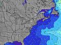 | 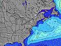 | 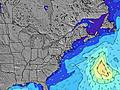 | 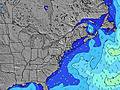 | 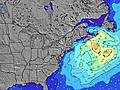 | 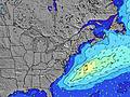 | 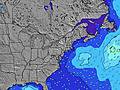 | |||||||||||||
Wave Height (m) Direction Period (s) | SSE 5 | SSE 6 | SSE 6 | SE 7 | SSE 7 | SE 7 | SSE 8 | SE 10 | SSE 8 | SSE 8 | S 8 | SSE 8 | SSE 7 | SSE 7 | S 7 | SSE 4 | SE 7 | SSE 7 | SSE 7 | SSE 7 |
Wave Graph | ||||||||||||||||||||
87 | 94 | 113 | 109 | 93 | 69 | 51 | 33 | 40 | 35 | 32 | 20 | 57 | 17 | 35 | 29 | 12 | 36 | 38 | 51 | |
Wind (km/h) | ||||||||||||||||||||
Wind State on-shore cross-onshore cross-shore cross-offshore off-shore glassy | on | cross-on | cross-off | cross-off | cross-off | cross-off | cross-off | off | glassy | cross-on | on | on | cross-on | cross-on | cross-on | cross-on | cross-on | cross | cross-off | off |
High Tide | 7:37PM1.60m | 8:04AM1.30m | 8:14PM1.61m | 8:41AM1.34m | 8:49PM1.60m | 9:17AM1.37m | 9:24PM1.57m | 9:54AM1.40m | 10:00PM1.53m | 10:32AM1.43m | 10:41PM1.47m | 11:14AM1.46m | 11:27PM1.41m | |||||||
Low Tide | 2:05AM0.05m | 2:04PM0.16m | 2:44AM0.02m | 2:45PM0.14m | 3:20AM-0.00m | 3:25PM0.14m | 3:55AM-0.01m | 4:04PM0.15m | 4:27AM-0.00m | 4:42PM0.17m | 5:00AM0.02m | 5:25PM0.20m | ||||||||
— | — | 5:48 | — | — | 5:48 | — | — | 5:50 | — | — | 5:50 | — | — | 5:52 | — | — | 5:52 | — | — | |
8:14 | — | — | 8:13 | — | — | 8:12 | — | — | 8:10 | — | — | 8:09 | — | — | 8:08 | — | — | 8:07 | — | |
mm | 8 | 11 | 1 | 3 | 4 | — | — | — | — | — | — | — | — | — | — | — | — | — | — | — |
Temp °C | 25 | 24 | 23 | 25 | 24 | 22 | 25 | 24 | 23 | 24 | 23 | 23 | 24 | 23 | 23 | 24 | 23 | 24 | 24 | 24 |
Feels °C | 23 | 22 | 24 | 27 | 25 | 21 | 24 | 22 | 24 | 23 | 22 | 24 | 24 | 22 | 23 | 24 | 23 | 26 | 26 | 26 |
Swell 1 Height (m) Direction Period (s) | E 6 | E 9 | SSE 6 | SE 7 | SSE 7 | SE 7 | SSE 8 | SSE 8 | SSE 8 | SSE 8 | S 8 | SSE 8 | SE 10 | SSE 7 | SE 8 | E 5 | S 4 | SSE 7 | SSE 7 | SSE 7 |
3 | 2 | 113 | 109 | 93 | 69 | 51 | 33 | 40 | 35 | 32 | 20 | 4 | 17 | 3 | 1 | 9 | 36 | 38 | 51 | |
Swell 2 Height (m) Direction Period (s) | SE 8 | E 9 | E 8 | E 6 | S 7 | ENE 6 | ESE 6 | ENE 5 | E 6 | E 6 | E 6 | SSE 6 | E 5 | SSE 10 | S 8 | E 5 | SE 7 | — | — | — |
3 | 6 | 1 | 1 | 10 | 6 | 6 | 9 | 2 | 3 | 1 | 4 | 1 | 9 | 1 | 1 | 12 | — | — | — | |
Swell 3 Height (m) Direction Period (s) | — | — | E 6 | E 8 | — | — | — | SE 10 | — | — | E 9 | SE 9 | — | SE 9 | E 5 | — | S 7 | — | — | — |
— | — | 1 | 1 | — | — | — | 23 | — | — | 2 | 3 | — | 3 | 1 | — | 4 | — | — | — | |
Wind waves Height (m) Direction Period (s) | SSE 5 | SSE 6 | — | — | NW 3 | NNW 2 | N 3 | N 3 | — | — | S 3 | — | SSE 7 | S 4 | S 7 | SSE 4 | — | — | SSE 3 | — |
87 | 94 | — | — | 2 | 1 | 5 | 1 | — | — | 1 | — | 57 | 11 | 35 | 29 | — | — | 3 | — | |
Nearest Offshore or Glassy | ||||||||||||||||||||
Distance (km) | 1703 | 172 | 0 | 0 | 0 | 6 | 0 | 0 | 3 | 126 | 40 | 126 | 159 | 161 | 816 | 1352 | 391 | 210 | 28 | 0 |
Best forecast wave conditions in Long Island New York | ||||||||||||||||||||
Best forecast wave conditions in United States | ||||||||||||||||||||
Header Global | ||||||||||||||||||||
- Map Icons:
 Break
Break Live Wave Height (m)
 Live Wind Speed (km/h)
 Surf Rating (10 Max)
 Ocean Swells (m)
- Wind Speed (km/h)


FREE! Surf-Forecast.com widget for your website
The surf report / weather widget below is available to embed on third party websites free of charge and provides a summary of our Long Beach surf forecast. Simply grab the html code snippet that we provide and paste it into your own site. You can choose your preferred language and metric/imperial units for the surf forecast feed to suit users of your site. Click here to get the code.
Information about the Long Beach Surf forecast
The above surf forecast table for Long Beach provides essential information for determining whether the surfing conditions will be good over the next 16 days. A general guide to surfing at Long Beach can be found by selecting the local surf guide option on the grey menu. Our Long Beach surf forecast is unique since it includes wave energy (power) that defines the real feel of the surf rather than just the height or the period. If you surf the same spot (Long Beach) regularly then make a mental note of the wave energy from the surf forecast table each time you go. Very soon you may start to choose your surf days based on the wave energy alone combined with our forecast of favourable offshore wind conditions. Our star ratings will help here and of course you will also find the usual wave height and period predictions on our surf forecasts as well as a full break down of the swell components under our advanced users option (to reveal that, click the little Einstein character under the tide times).
Further information to help with frequently asked questions about our surf forecast for Long Beach may be found under the help tab on the top menu and also by moving your mouse over the question marks on the surf forecast table itself. Please always bear in mind that the forecast is for near-shore open water and local factors at each surf break influence the actual breaking wave height, such as the beach / reef profile, water depths offshore and shelter.
Long Beach is 1 km (1 miles) from Long Beach. If you plan a vacation in Long Island New York, look for hotels and other accommodation in Long Beach. Long Beach has rooms for a wide range of budgets as well as car hire and transport links.
 Nearest