

Surf Forecasts:

Nahant Beach surf forecast from 3 Aug 2026:
- Best quality surf: Monday 3 Aug, 8PM (local time) - 3ft (0.9m), 6s period, SSE swell with offshore winds.
- Most powerful swell: Monday 3 Aug, 5PM (local time) - 3.5ft (1.1m), 8s period, SSE swell with 138 kJ wave energy.
- Next surfable swell (1★+): Monday 3 Aug, 8PM (local time) - 3ft (0.9m), 6s period with SSE swell.
Best Forecast Surf Conditions for Nahant Beach this week:
The surf forecast for Nahant Beach over the next 16 days: The first swell (rated 1 star or higher) is forecast to arrive on Monday (Aug 03) at 8PM. The primary swell is predicted to be 0.9m and 6s period. The wind is predicted to be offshore as the swell arrives.
The most powerful waves expected at Nahant Beach in the next 16 days are 1.1m 8s and forecast to arrive on Monday (Aug 03) at 5PM. Winds are predicted to be cross-offshore at the time the swell arrives. The largest open ocean swell (not directed at the beach) is 0.4m 3s period and expected on Monday (Aug 03) at 8PM.
| Wave Type | Time (EDT) & Date | Wave Height & Period |
|---|---|---|
| Next good surf (1 star+) | 8PM (Mon 3rd Aug) | 3ft (0.9m) 6s |
| Best Surf | 8PM (Mon 3rd Aug) | 3ft (0.9m) 6s |
| Most Powerful | 5PM (Mon 3rd Aug) | 3.5ft (1.1m) 8s |
Table - best surf conditions forecast for Nahant Beach over the next 16 days.
The Lowdown
Alright folks, Rusty here. I’ve had a good look at what’s cooking for the next couple of weeks, and I gotta be straight with you—it’s a tough stretch. We’ve got a real flat spell on the horizon, so don’t get your hopes up too high. Let’s start with the bigger picture, then we’ll pick through the scraps.
The whole 16-day window starts with a bit of a dud. Monday the 3rd of August is a no-go; the swell is tiny and messy with a storm risk and a stiff cross-off wind. The combined energy is weak (39). Tuesday the 4th of August offers our first real chance to get wet, but it’s a far cry from a classic. Nahant Beach is the only game in town, and it’s a beginner-friendly spot. It’s exposed to swell, but we’re dealing with a tiny 2ft SSE swell with a short period of 7 seconds — that’s windswell, not the good stuff. The combined energy is still low (60). The saving grace here is the light breeze and clean conditions, which will make it look okay for a longboard or a foamie. The water temperature is about average for the time of year, so not a shock to the system.
After that, it’s a long, painful stretch of nothing. From Wednesday the 5th of August all the way through Monday the 18th of August, the forecast is a desert. We’re talking wave heights that barely hit 2ft, periods that are mostly short and weak, and combined energy values that are just sad — mostly in the single digits or low double digits. There are some glassy mornings here and there, like early on Wednesday the 12th of August, but the swell is a pathetic 2ft from the ENE with a period of just 4 seconds. It’s practically flat. You’d be surfing ankle-snappers at best.
So, if you’re dying for a paddle, the only real standout — and I use that term loosely — is Tuesday the 4th of August. The offshore wind in the morning and the light cross-off in the afternoon will keep it clean. Don’t expect barrels; expect a fun, gentle wave for the kids or the beginners. The crowd at Nahant Beach can be an issue, so get there early for a chance at a few solo waves.
For the rest of the fortnight, honestly, the setup looks more interesting for a kite surfer than a paddle surfer, given the persistent small, weak swell and the occasional breezy afternoons. It’s a blank run, and that’s pretty normal for this area when the swell window goes quiet. Forecasts can change, but right now, this is a tough one to call a surf trip over.
Stay patient, keep your eye on the charts, and maybe wax up the longboard for that Tuesday morning session. That’s your best bet.
Rusty.
Short Range ForecastHeavy rain (total 48mm), heaviest during Mon afternoon. Warm (max 30°C on Tue afternoon, min 18°C on Mon night). Wind will be generally light. | Days 5-7 Weather SummaryLight rain (total 6mm), mostly falling on Wed night. Warm (max 35°C on Fri afternoon, min 22°C on Wed night). Wind will be generally light. | ||||||||||||||||||
Monday 3 | Tuesday 4 | Wednesday 5 | Thursday 6 | Friday 7 | Saturday 8 | ||||||||||||||
Night | AM | PM | Night | AM | PM | Night | AM | PM | Night | AM | PM | Night | AM | PM | Night | AM | PM | Night | |
Swell Height Map |  |  |  |  | 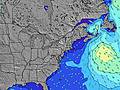 | 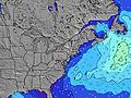 | 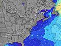 | ||||||||||||
Wave Height (m) Direction Period (s) | SE 4 | SE 5 | SSE 8 | SE 8 | SE 7 | SSE 7 | SE 5 | SE 7 | SE 7 | SE 5 | SE 6 | SSE 6 | SSE 5 | SE 7 | SSE 7 | SSE 5 | ESE 8 | SE 3 | SE 3 |
Wave Graph | |||||||||||||||||||
10 | 38 | 138 | 42 | 7 | 34 | 10 | 7 | 15 | 23 | 6 | 21 | 8 | 8 | 21 | 2 | 6 | 2 | 2 | |
Wind (km/h) | |||||||||||||||||||
Wind State on-shore cross-onshore cross-shore cross-offshore off-shore glassy | cross | cross-off | cross-off | off | off | cross-off | cross-off | cross | cross-on | cross-off | cross-off | cross-off | cross-off | cross-off | off | off | off | cross-on | off |
High Tide | 2:55AM2.87m | 3:21PM2.87m | 3:40AM2.79m | 4:04PM2.91m | 4:30AM2.70m | 4:52PM2.94m | 5:24AM2.62m | 5:45PM2.97m | 6:24AM2.54m | 6:43PM3.00m | 7:28AM2.51m | 7:45PM3.05m | |||||||
Low Tide | 8:46PM0.17m | 9:08AM0.04m | 9:32PM0.14m | 9:51AM0.10m | 10:21PM0.13m | 10:38AM0.17m | 11:15PM0.12m | 11:30AM0.24m | 00:14AM0.12m | 12:27PM0.30m | 1:17AM0.09m | 1:28PM0.30m | 2:20AM0.02m | ||||||
— | 5:37 | — | — | 5:37 | — | — | 5:39 | — | — | 5:39 | — | — | 5:41 | — | — | 5:41 | — | — | |
8:01 | — | 8:00 | — | — | 8:00 | — | — | 7:59 | — | — | 7:57 | — | — | 7:55 | — | — | 7:54 | — | |
mm | 1 | 4 | 22 | 8 | — | — | — | — | 13 | 3 | — | — | — | — | — | 3 | — | — | — |
Temp °C | 25 | 24 | 23 | 22 | 26 | 30 | 26 | 23 | 22 | 23 | 28 | 32 | 28 | 30 | 35 | 30 | 28 | 31 | 29 |
Feels °C | 25 | 24 | 23 | 23 | 24 | 28 | 24 | 25 | 24 | 26 | 31 | 33 | 29 | 31 | 34 | 32 | 29 | 33 | 30 |
Swell 1 Height (m) Direction Period (s) | SE 7 | E 8 | E 8 | SE 8 | SE 7 | SE 8 | SE 5 | SE 7 | SE 8 | SE 5 | SE 6 | SE 6 | SSE 5 | SE 7 | SE 7 | SSE 5 | ESE 8 | — | SE 3 |
2 | 1 | 1 | 42 | 7 | 23 | 10 | 7 | 3 | 23 | 6 | 6 | 8 | 8 | 9 | 2 | 6 | — | 2 | |
Swell 2 Height (m) Direction Period (s) | SE 9 | — | E 8 | E 8 | ESE 8 | E 9 | E 10 | E 10 | E 9 | E 9 | SE 8 | SE 8 | SE 8 | E 9 | E 9 | SE 8 | E 8 | E 8 | SE 7 |
3 | — | 1 | 1 | 7 | 2 | 2 | 2 | 2 | 2 | 3 | 2 | 2 | 2 | 2 | 2 | 1 | 1 | 2 | |
Swell 3 Height (m) Direction Period (s) | E 9 | — | — | — | E 9 | E 9 | E 10 | E 10 | — | E 8 | E 9 | E 9 | E 10 | — | — | E 8 | — | E 9 | E 8 |
2 | — | — | — | 2 | 1 | 2 | 2 | — | 1 | 2 | 2 | 2 | — | — | 1 | — | 2 | 1 | |
Wind waves Height (m) Direction Period (s) | SE 4 | SE 5 | SSE 8 | W 2 | — | SSE 7 | WSW 2 | — | SE 7 | — | — | SSE 6 | SW 3 | — | SSE 7 | — | — | SE 3 | — |
10 | 38 | 138 | 1 | — | 34 | 1 | — | 15 | — | — | 21 | 1 | — | 21 | — | — | 2 | — | |
Nearest Offshore or Glassy | |||||||||||||||||||
Distance (km) | 1253 | 1674 | 338 | 43 | 93 | 0 | 108 | 140 | 140 | 140 | 97 | 140 | 53 | 342 | 97 | 342 | 123 | 531 | 342 |
Best forecast wave conditions in Massachusetts | |||||||||||||||||||
Best forecast wave conditions in United States | |||||||||||||||||||
Header Global | |||||||||||||||||||
- Map Icons:
 Break
Break Live Wave Height (m)
 Live Wind Speed (km/h)
 Surf Rating (10 Max)
 Ocean Swells (m)
- Wind Speed (km/h)
Latest Updates


FREE! Surf-Forecast.com widget for your website
The surf report / weather widget below is available to embed on third party websites free of charge and provides a summary of our Nahant Beach surf forecast. Simply grab the html code snippet that we provide and paste it into your own site. You can choose your preferred language and metric/imperial units for the surf forecast feed to suit users of your site. Click here to get the code.
Information about the Nahant Beach Surf forecast
The above surf forecast table for Nahant Beach provides essential information for determining whether the surfing conditions will be good over the next 16 days. A general guide to surfing at Nahant Beach can be found by selecting the local surf guide option on the grey menu. Our Nahant Beach surf forecast is unique since it includes wave energy (power) that defines the real feel of the surf rather than just the height or the period. If you surf the same spot (Nahant Beach) regularly then make a mental note of the wave energy from the surf forecast table each time you go. Very soon you may start to choose your surf days based on the wave energy alone combined with our forecast of favourable offshore wind conditions. Our star ratings will help here and of course you will also find the usual wave height and period predictions on our surf forecasts as well as a full break down of the swell components under our advanced users option (to reveal that, click the little Einstein character under the tide times).
Further information to help with frequently asked questions about our surf forecast for Nahant Beach may be found under the help tab on the top menu and also by moving your mouse over the question marks on the surf forecast table itself. Please always bear in mind that the forecast is for near-shore open water and local factors at each surf break influence the actual breaking wave height, such as the beach / reef profile, water depths offshore and shelter.
Nahant Beach is 7 km (4 miles) from Lynn. If you plan a vacation in Massachusetts, look for hotels and other accommodation in Lynn. Lynn has rooms for a wide range of budgets as well as car hire and transport links.
 Nearest