

Surf Forecasts:

The Lighthouse surf forecast from 22 Jul 2026:
- Best quality surf: Friday 24 Jul, 5AM (local time) - 2ft (0.6m), 8s period, SE swell with offshore winds.
- Most powerful swell: Friday 24 Jul, 5AM (local time) - 2ft (0.6m), 8s period, SE swell with 57 kJ wave energy.
- Next surfable swell (1★+): Friday 24 Jul, 5AM (local time) - 2ft (0.6m), 8s period with SE swell.
Best Forecast Surf Conditions for The Lighthouse this week:
The surf forecast for The Lighthouse over the next 16 days: The first swell (rated 1 star or higher) is forecast to arrive on Friday (Jul 24) at 5AM. The primary swell is predicted to be 0.6m and 8s period with a secondary swell of 0.1m and 5s. The wind is predicted to be offshore as the swell arrives.
The most powerful waves expected at The Lighthouse in the next 16 days are 0.6m 8s and forecast to arrive on Friday (Jul 24) at 5AM. Winds are predicted to be offshore at the time the swell arrives. The largest open ocean swell (not directed at the beach) is 1.9m 7s period and expected on Wednesday (Jul 22) at 5AM.
| Wave Type | Time (EDT) & Date | Wave Height & Period |
|---|---|---|
| Next good surf (1 star+) | 5AM (Fri 24th Jul) | 2ft (0.6m) 8s |
| Best Surf | 5AM (Fri 24th Jul) | 2ft (0.6m) 8s |
| Most Powerful | 5AM (Fri 24th Jul) | 2ft (0.6m) 8s |
Table - best surf conditions forecast for The Lighthouse over the next 16 days.
The Lowdown
Alright folks, Rusty here. Let’s look at what’s on offer for The Lighthouse over the next couple of weeks. I gotta be straight with you – it’s a pretty grim run. This spot is a beach and jetty setup, exposed to the swell, but the energy is just not lining up for us.
Right off the bat, Tuesday the 21st through to the end of the month is a write-off. We’ve got a flat spell stretching for over a week. The little bumps we see are tiny, mushy, and paired with strong winds. The water temp is sitting at 82°, which is about average for this time of year.
We finally see a glimmer of life on Monday the 3rd of August. The morning brings a tiny 3ft swell from the east-southeast, but it’s a short-period, weak windswell with a combined energy of only 78. The wind is light and cross-offshore though, so the surface will be clean. It’s surfable, but it’s very ordinary – the kind of day you’d only go out if you were desperate for a paddle.
Tuesday the 4th of August is a similar story. A 2ft swell from the southeast, again with a poor period of 7 seconds, and combined energy of 50. The wind is light and cross-offshore, so the conditions will be clean. But again, it’s just not enough power to get excited about.
There’s nothing here that I’d call a standout. The best of a bad bunch is the morning of Monday the 3rd of August or Tuesday the 4th of August – tiny, clean waves for the patient soul. Don’t hold your breath for anything else.
Rusty, signing off.
Short Range ForecastHeavy rain (total 78mm), heaviest during Thu afternoon. Warm (max 28°C on Tue afternoon, min 24°C on Thu afternoon). Winds decreasing (near gales from the SW on Tue night, light winds from the W by Thu night). | Days 5-7 Weather SummaryHeavy rain (total 79mm), heaviest during Sat morning. Warm (max 27°C on Mon morning, min 22°C on Sat morning). Wind will be generally light. | |||||||||||||||||||
Tue 21 | Wednesday 22 | Thursday 23 | Friday 24 | Saturday 25 | Sunday 26 | Monday 27 | ||||||||||||||
PM | Night | AM | PM | Night | AM | PM | Night | AM | PM | Night | AM | PM | Night | AM | PM | Night | AM | PM | Night | |
Swell Height Map | 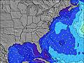 | 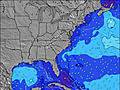 | 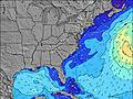 | 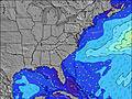 | 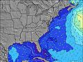 | 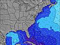 | 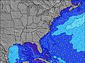 | |||||||||||||
Wave Height (m) Direction Period (s) | SE 8 | SE 8 | SE 9 | SE 9 | SE 8 | SSW 6 | S 6 | SE 8 | SE 8 | SE 8 | SE 8 | SE 7 | SE 8 | SE 8 | SE 8 | SE 8 | SE 8 | SE 8 | SE 8 | SE 8 |
Wave Graph | ||||||||||||||||||||
11 | 21 | 22 | 49 | 35 | 0 | 0 | 24 | 41 | 38 | 35 | 34 | 35 | 37 | 30 | 29 | 20 | 20 | 16 | 17 | |
Wind (km/h) | ||||||||||||||||||||
Wind State on-shore cross-onshore cross-shore cross-offshore off-shore glassy | cross-off | cross-off | cross-off | cross-off | cross-off | cross-off | cross-on | off | cross-off | cross-off | off | cross-on | cross | cross | cross | cross-on | cross-off | cross-off | cross-off | cross-off |
High Tide | 2:06PM0.95m | 2:09AM0.73m | 3:03PM0.95m | 3:06AM0.68m | 3:59PM0.96m | 4:05AM0.65m | 4:52PM0.98m | 5:00AM0.65m | 5:41PM1.01m | 5:50AM0.66m | 6:26PM1.04m | 6:35AM0.69m | 7:07PM1.06m | |||||||
Low Tide | 8:27PM0.21m | 8:16AM0.09m | 9:33PM0.24m | 9:06AM0.12m | 10:36PM0.24m | 9:58AM0.13m | 11:31PM0.23m | 10:49AM0.13m | 00:19AM0.20m | 11:38AM0.11m | 1:02AM0.17m | 12:24PM0.08m | 1:40AM0.14m | |||||||
— | — | 6:03 | — | — | 6:03 | — | — | 6:03 | — | — | 6:05 | — | — | 6:05 | — | — | 6:05 | — | — | |
8:14 | — | — | 8:13 | — | — | 8:12 | — | — | 8:12 | — | — | 8:10 | — | — | 8:09 | — | — | 8:08 | — | |
mm | — | — | 3 | 8 | 2 | 7 | 33 | 13 | 12 | 9 | 34 | 30 | 1 | — | — | — | 1 | 4 | 1 | 1 |
Temp °C | 28 | 28 | 28 | 28 | 28 | 28 | 27 | 26 | 24 | 24 | 24 | 22 | 23 | 24 | 24 | 24 | 26 | 27 | 28 | 28 |
Feels °C | 27 | 25 | 24 | 25 | 26 | 27 | 27 | 28 | 27 | 25 | 27 | 21 | 25 | 25 | 23 | 24 | 27 | 28 | 28 | 27 |
Swell 1 Height (m) Direction Period (s) | SE 8 | SE 8 | SE 9 | SE 9 | SE 8 | SE 8 | S 6 | SSW 6 | SE 8 | SE 8 | SE 8 | SE 7 | SE 8 | SE 8 | SE 8 | SE 8 | SE 8 | SE 8 | SE 8 | SE 8 |
11 | 21 | 22 | 49 | 35 | 16 | 59 | 10 | 41 | 38 | 35 | 34 | 35 | 37 | 30 | 29 | 20 | 20 | 15 | 17 | |
Swell 2 Height (m) Direction Period (s) | E 10 | E 9 | — | — | — | — | SE 8 | SE 8 | NNE 5 | NE 5 | NE 5 | SSW 5 | NE 6 | SSW 6 | S 5 | NE 6 | ENE 6 | ENE 6 | ENE 6 | NE 5 |
2 | 2 | — | — | — | — | 16 | 24 | 3 | 1 | 1 | 5 | 11 | 6 | 5 | 5 | 4 | 4 | 3 | 1 | |
Swell 3 Height (m) Direction Period (s) | — | — | — | — | — | — | — | NE 5 | — | — | — | — | SSW 5 | — | E 12 | S 5 | — | E 11 | ESE 9 | — |
— | — | — | — | — | — | — | 1 | — | — | — | — | 5 | — | 3 | 5 | — | 3 | 16 | — | |
Wind waves Height (m) Direction Period (s) | SSW 6 | S 7 | S 7 | S 7 | S 7 | SSW 6 | — | SE 5 | S 5 | S 5 | SW 4 | NE 4 | NE 5 | NE 6 | NE 6 | — | SSW 5 | SSW 3 | SSW 4 | SSW 5 |
126 | 302 | 338 | 274 | 258 | 150 | — | 7 | 49 | 24 | 16 | 15 | 19 | 9 | 9 | — | 9 | 3 | 22 | 75 | |
Nearest Offshore or Glassy | ||||||||||||||||||||
Distance (km) | 1040 | 293 | 171 | 171 | 95 | 356 | 14 | 14 | 29 | 29 | 14 | 73 | 14 | 14 | 14 | 709 | 78 | 37 | 1096 | 349 |
Best forecast wave conditions in North Carolina | ||||||||||||||||||||
Best forecast wave conditions in United States | ||||||||||||||||||||
Header Global | ||||||||||||||||||||
- Map Icons:
 Break
Break Live Wave Height (m)
 Live Wind Speed (km/h)
 Surf Rating (10 Max)
 Ocean Swells (m)
- Wind Speed (km/h)


FREE! Surf-Forecast.com widget for your website
The surf report / weather widget below is available to embed on third party websites free of charge and provides a summary of our The Lighthouse surf forecast. Simply grab the html code snippet that we provide and paste it into your own site. You can choose your preferred language and metric/imperial units for the surf forecast feed to suit users of your site. Click here to get the code.
Information about the The Lighthouse Surf forecast
The above surf forecast table for The Lighthouse provides essential information for determining whether the surfing conditions will be good over the next 16 days. A general guide to surfing at The Lighthouse can be found by selecting the local surf guide option on the grey menu. Our The Lighthouse surf forecast is unique since it includes wave energy (power) that defines the real feel of the surf rather than just the height or the period. If you surf the same spot (The Lighthouse) regularly then make a mental note of the wave energy from the surf forecast table each time you go. Very soon you may start to choose your surf days based on the wave energy alone combined with our forecast of favourable offshore wind conditions. Our star ratings will help here and of course you will also find the usual wave height and period predictions on our surf forecasts as well as a full break down of the swell components under our advanced users option (to reveal that, click the little Einstein character under the tide times).
Further information to help with frequently asked questions about our surf forecast for The Lighthouse may be found under the help tab on the top menu and also by moving your mouse over the question marks on the surf forecast table itself. Please always bear in mind that the forecast is for near-shore open water and local factors at each surf break influence the actual breaking wave height, such as the beach / reef profile, water depths offshore and shelter.
Are you planning a vacation in North Carolina? If you are looking for accommodation near The Lighthouse, camping, hotels and condos and appartments in North Carolina, consider staying in Cape Hatteras which is 16 km (10 miles) away.
 Nearest