

Surf Forecasts:

Springmaid Beach surf forecast from 31 Jul 2026:
- Most powerful swell: Monday 3 Aug, 8AM (local time) - 5.5ft (1.7m), 7s period, S swell with 303 kJ wave energy.
Best Forecast Surf Conditions for Springmaid Beach this week:
The most powerful waves expected at Springmaid Beach in the next 16 days are 1.7m 7s and forecast to arrive on Monday (Aug 03) at 8AM. Winds are predicted to be cross-shore at the time the swell arrives.
| Wave Type | Time (EDT) & Date | Wave Height & Period |
|---|---|---|
| Next good surf (1 star+) | - | - |
| Best Surf | - | - |
| Most Powerful | 8AM (Mon 3rd Aug) | 5.5ft (1.7m) 7s |
Table - best surf conditions forecast for Springmaid Beach over the next 16 days.
The Lowdown
Alright folks, Rusty here. Let’s have a look at what’s lined up for Springmaid Beach over the next couple of weeks.
Honestly, it’s a tough stretch ahead. The whole 16-day window is looking pretty flat and messy. We’ve got a gap of nothing but poor surf conditions right from the start, all the way through until the morning of the 11th of August. There’s just no real swell to get excited about. The water temp is sitting at 84° on the 31st of July, which is a touch warmer than normal for this time of year, but that’s about the only thing going for it.
The first whiff of anything surfable comes on Tuesday morning, the 11th of August. We get a tiny bit of swell from the south at 3ft, with a short period of 5 seconds. The wind will be a light westerly, coming cross-off the land, which will keep the surface clean. The combined wave energy is a weak 58, so it’s not going to have any punch. It’s surfable, but very ordinary. The break itself is a beginner-friendly beach and pier, and it’s fairly consistent, but with these tiny waves, it’s really only a longboard or foiling kind of day. Crowds are a possibility here sometimes.
The next little window is Wednesday morning, the 12th of August. Similar story: a south-southwest swell at 3ft, period of 5 seconds, and a glassy morning with a light northwesterly wind. The energy is still weak at 60. It’s clean, but again, very ordinary. After that, it’s back to poor conditions for the rest of the week.
This is a classic case of the area going quiet. There’s nothing that stands out as a good option. The best you can hope for is a clean, small wave session on the 11th or 12th if you’re desperate for a paddle. Otherwise, you’re better off waiting for the next system.
Rusty.
Short Range ForecastHeavy rain (total 27mm), heaviest during Mon morning. Warm (max 30°C on Fri afternoon, min 24°C on Mon morning). Mainly fresh winds. | Days 5-7 Weather SummaryHeavy rain (total 51mm), heaviest during Mon afternoon. Warm (max 27°C on Tue night, min 23°C on Mon afternoon). Wind will be generally light. | |||||||||||||||||||
Fri 31 | Saturday 1 | Sunday 2 | Monday 3 | Tuesday 4 | Wednesday 5 | Thursday 6 | ||||||||||||||
PM | Night | AM | PM | Night | AM | PM | Night | AM | PM | Night | AM | PM | Night | AM | PM | Night | AM | PM | Night | |
Swell Height Map | 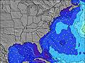 | 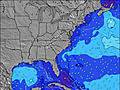 | 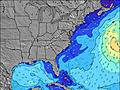 | 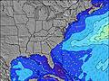 | 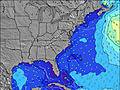 | 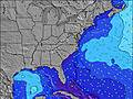 | 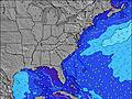 | |||||||||||||
Wave Height (m) Direction Period (s) | SSE 6 | SSE 6 | SE 4 | SE 4 | SE 4 | SE 6 | SSE 7 | SSE 8 | S 7 | SSE 7 | S 7 | S 6 | SE 7 | SE 6 | SE 6 | SSE 6 | SE 6 | SE 7 | SE 7 | SE 7 |
Wave Graph | ||||||||||||||||||||
8 | 12 | 7 | 9 | 9 | 77 | 105 | 151 | 155 | 105 | 117 | 26 | 54 | 46 | 56 | 27 | 26 | 21 | 36 | 15 | |
Wind (km/h) | ||||||||||||||||||||
Wind State on-shore cross-onshore cross-shore cross-offshore off-shore glassy | cross-on | cross-on | on | on | cross-on | cross-on | cross-on | cross-on | cross | cross | cross-on | cross-on | on | cross-on | cross | cross-on | cross-on | glassy | on | cross-on |
High Tide | 9:42PM1.78m | 10:00AM1.57m | 10:21PM1.73m | 10:42AM1.60m | 11:02PM1.64m | 11:29AM1.63m | 11:48PM1.55m | 12:21PM1.66m | 00:40AM1.47m | 1:18PM1.69m | 1:39AM1.40m | 2:19PM1.74m | 2:43AM1.37m | |||||||
Low Tide | 3:26PM0.20m | 4:03AM0.11m | 4:07PM0.20m | 4:39AM0.10m | 4:50PM0.23m | 5:16AM0.09m | 5:37PM0.25m | 5:57AM0.09m | 6:29PM0.28m | 6:43AM0.09m | 7:29PM0.31m | 7:37AM0.09m | 8:38PM0.32m | |||||||
— | — | 6:26 | — | — | 6:26 | — | — | 6:28 | — | — | 6:28 | — | — | 6:30 | — | — | 6:30 | — | — | |
8:15 | — | — | 8:15 | — | — | 8:15 | — | — | 8:14 | — | — | 8:13 | — | — | 8:12 | — | — | 8:10 | — | |
mm | — | — | — | — | — | 5 | 1 | 4 | 17 | 16 | 12 | 8 | 1 | 1 | 4 | 3 | 2 | 4 | — | — |
Temp °C | 30 | 28 | 28 | 29 | 28 | 28 | 29 | 27 | 26 | 23 | 26 | 25 | 26 | 27 | 27 | 27 | 27 | 27 | 28 | 27 |
Feels °C | 30 | 29 | 29 | 30 | 30 | 29 | 28 | 26 | 25 | 25 | 26 | 27 | 26 | 28 | 30 | 29 | 30 | 31 | 31 | 30 |
Swell 1 Height (m) Direction Period (s) | SSE 6 | E 9 | SE 9 | SE 9 | SE 6 | SE 6 | — | — | — | — | SE 8 | SE 7 | SE 7 | SE 6 | SE 6 | SSE 6 | SE 6 | SE 7 | SE 7 | SE 7 |
8 | 2 | 3 | 3 | 1 | 32 | — | — | — | — | 16 | 22 | 54 | 46 | 56 | 27 | 26 | 21 | 36 | 15 | |
Swell 2 Height (m) Direction Period (s) | E 10 | — | — | SE 7 | SE 8 | — | — | — | — | — | — | — | — | — | S 5 | — | SSW 4 | — | E 11 | — |
2 | — | — | 2 | 3 | — | — | — | — | — | — | — | — | — | 1 | — | 2 | — | 2 | — | |
Swell 3 Height (m) Direction Period (s) | — | — | — | — | — | — | — | — | — | — | — | — | — | — | — | — | — | — | — | — |
— | — | — | — | — | — | — | — | — | — | — | — | — | — | — | — | — | — | — | — | |
Wind waves Height (m) Direction Period (s) | — | SSE 6 | SE 4 | SE 4 | SE 4 | SE 6 | SSE 7 | SSE 8 | S 7 | SSE 7 | S 7 | S 6 | SSE 6 | SE 6 | SSE 6 | SSW 5 | — | — | — | — |
— | 12 | 7 | 9 | 9 | 77 | 105 | 151 | 155 | 105 | 117 | 26 | 37 | 39 | 33 | 2 | — | — | — | — | |
Nearest Offshore or Glassy | ||||||||||||||||||||
Distance (km) | 1027 | 378 | 837 | 797 | 1284 | 496 | 495 | 481 | 481 | 22 | 434 | 97 | 444 | 434 | 22 | 97 | 434 | 49 | 959 | 711 |
Best forecast wave conditions in South Carolina | ||||||||||||||||||||
Best forecast wave conditions in United States | ||||||||||||||||||||
Header Global | ||||||||||||||||||||
- Map Icons:
 Break
Break Live Wave Height (m)
 Live Wind Speed (km/h)
 Surf Rating (10 Max)
 Ocean Swells (m)
- Wind Speed (km/h)
Latest Updates


FREE! Surf-Forecast.com widget for your website
The surf report / weather widget below is available to embed on third party websites free of charge and provides a summary of our Springmaid Beach surf forecast. Simply grab the html code snippet that we provide and paste it into your own site. You can choose your preferred language and metric/imperial units for the surf forecast feed to suit users of your site. Click here to get the code.
Information about the Springmaid Beach Surf forecast
The above surf forecast table for Springmaid Beach provides essential information for determining whether the surfing conditions will be good over the next 16 days. A general guide to surfing at Springmaid Beach can be found by selecting the local surf guide option on the grey menu. Our Springmaid Beach surf forecast is unique since it includes wave energy (power) that defines the real feel of the surf rather than just the height or the period. If you surf the same spot (Springmaid Beach) regularly then make a mental note of the wave energy from the surf forecast table each time you go. Very soon you may start to choose your surf days based on the wave energy alone combined with our forecast of favourable offshore wind conditions. Our star ratings will help here and of course you will also find the usual wave height and period predictions on our surf forecasts as well as a full break down of the swell components under our advanced users option (to reveal that, click the little Einstein character under the tide times).
Further information to help with frequently asked questions about our surf forecast for Springmaid Beach may be found under the help tab on the top menu and also by moving your mouse over the question marks on the surf forecast table itself. Please always bear in mind that the forecast is for near-shore open water and local factors at each surf break influence the actual breaking wave height, such as the beach / reef profile, water depths offshore and shelter.
Springmaid Beach is 1 km (1 miles) from Myrtle Beach. If you plan a vacation in South Carolina, look for hotels and other accommodation in Myrtle Beach. Myrtle Beach has rooms for a wide range of budgets as well as car hire and transport links.
 Nearest