

Surf Forecasts:

Damneck Naval Base surf forecast from 3 Aug 2026:
- Best quality surf: Monday 3 Aug, 11PM (local time) - 4.5ft (1.4m), 7s period, SSE swell with cross-offshore winds.
- Most powerful swell: Monday 3 Aug, 11PM (local time) - 4.5ft (1.4m), 7s period, SSE swell with 214 kJ wave energy.
- Next surfable swell (1★+): Monday 3 Aug, 11PM (local time) - 4.5ft (1.4m), 7s period with SSE swell.
Best Forecast Surf Conditions for Damneck Naval Base this week:
The surf forecast for Damneck Naval Base over the next 16 days: The first swell (rated 1 star or higher) is forecast to arrive on Monday (Aug 03) at 11PM. The primary swell is predicted to be 1.4m and 7s period with a secondary swell of 1.2m and 7s. Another secondary swell of 0.1m and 13s is also forecast. The wind is predicted to be cross-offshore as the swell arrives.
The most powerful waves expected at Damneck Naval Base in the next 16 days are 1.4m 7s and forecast to arrive on Monday (Aug 03) at 11PM. Winds are predicted to be cross-offshore at the time the swell arrives. The largest open ocean swell (not directed at the beach) is 0.9m 4s period and expected on Wednesday (Aug 05) at 11PM.
| Wave Type | Time (EDT) & Date | Wave Height & Period |
|---|---|---|
| Next good surf (1 star+) | 11PM (Mon 3rd Aug) | 4.5ft (1.4m) 7s |
| Best Surf | 11PM (Mon 3rd Aug) | 4.5ft (1.4m) 7s |
| Most Powerful | 11PM (Mon 3rd Aug) | 4.5ft (1.4m) 7s |
Table - best surf conditions forecast for Damneck Naval Base over the next 16 days.
The Lowdown
Alright, let me tell ya straight up, it's been a tough run at Damneck Naval Base. I’ve been lookin’ at the charts and there’s a big ol’ gap with nothin’ worth paddlin’ out for from now right through to the end of the first week of August. We're talkin' close to a week of flat, messy, or just plain weak conditions. The water temp is sittin' around 78°, which is pretty much normal for this time of year, so at least you won't be freezin' while you're waitin' for somethin' to show up.
The first real glimmer of hope comes on Monday, the 17th of August. The morning session is the one to aim for. We've got a little 3ft swell creepin' in from the ENE, and the wind is glassy – absolute dead calm. That's a rare treat, and for a spot that's fairly consistent, it'll be clean as a whistle. It's a beginner-friendly wave size, so it won't be too heavy, but the energy is still pretty weak (87). It's surfable, but don't expect any barrels.
Honestly, after that glassy morning on the 17th, the rest of the forecast window just fizzles out again. The afternoon of the 17th gets chopped up by a cross-shore, and Tuesday the 18th is a write-off with weak 2ft ENE swell and a messy cross-shore wind. There's no standout period here; that one Monday morning is the only time the stars even partially align. It's been a lean stretch.
Rusty
Short Range ForecastModerate rain (total 12mm), heaviest on Mon night. Warm (max 29°C on Mon afternoon, min 24°C on Tue night). Wind will be generally light. | Days 4-6 Weather SummarySome drizzle, heaviest during Thu morning. Warm (max 34°C on Sat afternoon, min 24°C on Sat night). Wind will be generally light. | ||||||||||||||||||||
Monday 3 | Tuesday 4 | Wednesday 5 | Thursday 6 | Friday 7 | Saturday 8 | Sunday 9 | |||||||||||||||
AM | PM | Night | AM | PM | Night | AM | PM | Night | AM | PM | Night | AM | PM | Night | AM | PM | Night | AM | PM | Night | |
Swell Height Map |  | 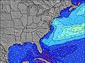 | 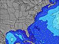 | 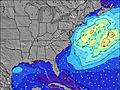 |  | 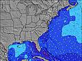 | 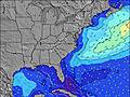 | ||||||||||||||
Wave Height (m) Direction Period (s) | SE 8 | SSE 7 | SE 7 | SE 8 | SE 7 | SE 6 | SE 7 | SE 6 | ESE 7 | SE 6 | SSE 4 | SE 6 | SSE 6 | SE 7 | ESE 8 | SE 8 | SE 8 | SSE 5 | SE 7 | SE 7 | ESE 7 |
Wave Graph | |||||||||||||||||||||
147 | 207 | 89 | 55 | 39 | 40 | 35 | 42 | 18 | 31 | 34 | 10 | 25 | 14 | 24 | 49 | 28 | 27 | 12 | 12 | 5 | |
Wind (km/h) | |||||||||||||||||||||
Wind State on-shore cross-onshore cross-shore cross-offshore off-shore glassy | cross-off | cross-off | glassy | cross-on | cross-off | off | cross-off | cross-off | cross-off | cross-off | cross-off | cross-off | off | cross-off | cross-off | off | cross-off | off | off | cross-off | cross-off |
High Tide | 11:43AM1.14m | 11:52PM1.04m | 12:27PM1.18m | 00:37AM0.98m | 1:16PM1.21m | 1:28AM0.93m | 2:15PM1.22m | 2:32AM0.89m | 3:24PM1.24m | 3:47AM0.88m | 4:31PM1.28m | 4:57AM0.92m | 5:34PM1.32m | ||||||||
Low Tide | 5:55PM0.17m | 6:05AM0.04m | 6:49PM0.19m | 6:50AM0.05m | 7:47PM0.20m | 7:42AM0.06m | 8:55PM0.20m | 8:43AM0.08m | 10:04PM0.18m | 9:49AM0.07m | 11:08PM0.14m | 10:54AM0.05m | 00:13AM0.08m | ||||||||
6:09 | — | — | 6:11 | — | — | 6:11 | — | — | 6:13 | — | — | 6:13 | — | — | 6:13 | — | — | 6:15 | — | — | |
— | 8:07 | — | — | 8:07 | — | — | 8:06 | — | — | 8:05 | — | — | 8:04 | — | — | 8:02 | — | — | 8:01 | — | |
mm | — | 2 | 5 | — | 3 | 2 | — | — | — | 1 | — | — | — | — | — | — | — | — | — | — | — |
Temp °C | 28 | 29 | 26 | 27 | 27 | 24 | 24 | 29 | 27 | 29 | 32 | 29 | 29 | 33 | 30 | 29 | 34 | 31 | 29 | 34 | 31 |
Feels °C | 28 | 29 | 28 | 30 | 30 | 27 | 26 | 28 | 29 | 31 | 32 | 30 | 31 | 33 | 30 | 30 | 34 | 31 | 29 | 33 | 31 |
Swell 1 Height (m) Direction Period (s) | SE 8 | — | SE 7 | SE 8 | SE 7 | SE 6 | SE 7 | NE 5 | ESE 7 | SE 6 | E 10 | SE 6 | SSE 6 | SE 7 | ESE 8 | SE 8 | SE 8 | SSE 5 | S 4 | SE 7 | ESE 7 |
147 | — | 89 | 55 | 39 | 40 | 35 | 1 | 18 | 31 | 2 | 10 | 25 | 14 | 24 | 49 | 28 | 27 | 9 | 12 | 5 | |
Swell 2 Height (m) Direction Period (s) | — | — | E 13 | E 14 | NE 5 | NE 5 | NE 5 | E 9 | NE 4 | E 10 | NE 10 | E 9 | E 9 | E 9 | E 9 | E 9 | E 9 | ESE 7 | SE 7 | E 9 | E 9 |
— | — | 4 | 4 | 1 | 4 | 4 | 1 | 1 | 2 | 4 | 2 | 2 | 2 | 2 | 2 | 2 | 20 | 12 | 2 | 1 | |
Swell 3 Height (m) Direction Period (s) | — | — | — | — | — | — | E 9 | E 11 | E 10 | — | E 11 | E 11 | — | — | — | — | — | E 9 | E 8 | E 11 | E 11 |
— | — | — | — | — | — | 2 | 2 | 2 | — | 2 | 2 | — | — | — | — | — | 1 | 1 | 2 | 2 | |
Wind waves Height (m) Direction Period (s) | SW 4 | SSE 7 | — | — | S 3 | — | — | SE 6 | SSE 5 | — | SSE 4 | S 5 | SW 3 | S 4 | S 5 | SW 3 | S 3 | W 3 | WSW 3 | SSW 3 | S 6 |
3 | 207 | — | — | 5 | — | — | 42 | 32 | — | 34 | 34 | 2 | 9 | 29 | 2 | 5 | 1 | 2 | 3 | 48 | |
Nearest Offshore or Glassy | |||||||||||||||||||||
Distance (km) | 14 | 205 | 0 | 46 | 0 | 0 | 0 | 77 | 411 | 235 | 622 | 622 | 164 | 406 | 137 | 0 | 14 | 0 | 459 | 235 | 187 |
Best forecast wave conditions in Virginia | |||||||||||||||||||||
Best forecast wave conditions in United States | |||||||||||||||||||||
Header Global | |||||||||||||||||||||
- Map Icons:
 Break
Break Live Wave Height (m)
 Live Wind Speed (km/h)
 Surf Rating (10 Max)
 Ocean Swells (m)
- Wind Speed (km/h)
Latest Updates


FREE! Surf-Forecast.com widget for your website
The surf report / weather widget below is available to embed on third party websites free of charge and provides a summary of our Damneck Naval Base surf forecast. Simply grab the html code snippet that we provide and paste it into your own site. You can choose your preferred language and metric/imperial units for the surf forecast feed to suit users of your site. Click here to get the code.
Information about the Damneck Naval Base Surf forecast
The above surf forecast table for Damneck Naval Base provides essential information for determining whether the surfing conditions will be good over the next 16 days. A general guide to surfing at Damneck Naval Base can be found by selecting the local surf guide option on the grey menu. Our Damneck Naval Base surf forecast is unique since it includes wave energy (power) that defines the real feel of the surf rather than just the height or the period. If you surf the same spot (Damneck Naval Base) regularly then make a mental note of the wave energy from the surf forecast table each time you go. Very soon you may start to choose your surf days based on the wave energy alone combined with our forecast of favourable offshore wind conditions. Our star ratings will help here and of course you will also find the usual wave height and period predictions on our surf forecasts as well as a full break down of the swell components under our advanced users option (to reveal that, click the little Einstein character under the tide times).
Further information to help with frequently asked questions about our surf forecast for Damneck Naval Base may be found under the help tab on the top menu and also by moving your mouse over the question marks on the surf forecast table itself. Please always bear in mind that the forecast is for near-shore open water and local factors at each surf break influence the actual breaking wave height, such as the beach / reef profile, water depths offshore and shelter.
Damneck Naval Base is 8 km (5 miles) from the city of Virginia Beach. If you plan a vacation in Virginia, look for hotels and other accommodation in Virginia Beach. Virginia Beach has rooms for a wide range of budgets as well as car hire and transport links.
 Nearest