

Surf Forecasts:

Waverly surf forecast from 3 Aug 2026:
- Best quality surf: Monday 3 Aug, 8PM (local time) - 5ft (1.5m), 8s period, S swell with cross-offshore winds.
- Most powerful swell: Monday 3 Aug, 5PM (local time) - 5.5ft (1.7m), 8s period, S swell with 383 kJ wave energy.
- Next surfable swell (1★+): Monday 3 Aug, 8PM (local time) - 5ft (1.5m), 8s period with S swell.
Best Forecast Surf Conditions for Waverly this week:
The surf forecast for Waverly over the next 16 days: The first swell (rated 1 star or higher) is forecast to arrive on Monday (Aug 03) at 8PM. The primary swell is predicted to be 1.5m and 8s period. The wind is predicted to be cross-offshore as the swell arrives.
The most powerful waves expected at Waverly in the next 16 days are 1.7m 8s and forecast to arrive on Monday (Aug 03) at 5PM. Winds are predicted to be cross-offshore at the time the swell arrives.
| Wave Type | Time (EDT) & Date | Wave Height & Period |
|---|---|---|
| Next good surf (1 star+) | 8PM (Mon 3rd Aug) | 5ft (1.5m) 8s |
| Best Surf | 8PM (Mon 3rd Aug) | 5ft (1.5m) 8s |
| Most Powerful | 5PM (Mon 3rd Aug) | 5.5ft (1.7m) 8s |
Table - best surf conditions forecast for Waverly over the next 16 days.
The Lowdown
Alright folks, Rusty here. Let’s be straight with you – the outlook for Waverly over the next two weeks is a tough one. We’ve got a real dry spell on our hands, with very little to get excited about. The first real chance of anything surfable doesn't even show up until the 8th of August, and even then it’s marginal at best. There’s a long stretch of poor conditions from the start, with plenty of wind chop and weak energy.
The only break on the cards is Waverly, a breakwater setup that’s very consistent but needs a specific swell direction. It’s a fairly exposed spot, but the swell we’re seeing is mostly short-period, sloppy stuff from the SSE and S, which isn't its ideal angle. The water temp is about average for the time of year, nothing weird there.
Let’s break it down. Monday the 3rd kicks off with a risk of thunderstorms and a moderate breeze. We’ve got a 5ft SSE swell at 8 seconds, but the wind is cross, and the combined energy is moderate (299). It’s a no-go. That afternoon, things clean up a little on the wind front with a 6ft S swell, but the cross-off wind and marginal quality mean it’s not worth paddling out.
Tuesday the 4th through to the 7th is a write-off. Strong onshore winds, tiny swells, and periods of barely 6 seconds. The combined energy drops into the low two-digit numbers – weak stuff. The only glimmer is Friday the 7th morning, where we get a clean, 3ft S swell with a cross-off breeze, but the period is still a short 6 seconds and the energy is only moderate (127). It’s clean but small.
Now, the one standout – if you can call it that – is Saturday the 8th of August. The morning shows a 3ft S swell, the wind is a gentle cross-off breeze, and the conditions are clean. The combined energy is moderate (109). It’s still short period (6 seconds), so it’s not going to have any punch, but it’s the cleanest window we’ve got. It’s surfable, but very ordinary. Don’t expect any barrels. Crowds are possible here on a clean day, so don’t be surprised if you see a few others out.
After that, the 9th through the 14th is more of the same – tiny, weak, short-period swell with mostly cross-shore wind. The 15th of August morning has a bit of a bump with a 5ft S swell at 7 seconds and a fresh cross-off wind, giving it moderate energy (262). It’s clean, but the short period and chop will make it a work-up. The 17th of August morning is glassy with a 0.7ft SSE swell, but that’s barely a ripple.
Honestly, the only day that’s worth a look is the 8th of August morning. It’s not going to be epic, but it’s the cleanest, most surfable slot in the entire 16-day window. The rest is a waiting game.
Rusty.
Short Range ForecastHeavy rain (total 42mm), heaviest during Mon afternoon. Warm (max 27°C on Wed afternoon, min 22°C on Mon night). Winds decreasing (fresh winds from the SSW on Sun night, light winds from the WNW by Mon night). | Days 5-7 Weather SummaryLight rain (total 3mm), mostly falling on Wed night. Warm (max 31°C on Sat afternoon, min 24°C on Wed night). Wind will be generally light. | ||||||||||||||||||
Monday 3 | Tuesday 4 | Wednesday 5 | Thursday 6 | Friday 7 | Saturday 8 | ||||||||||||||
Night | AM | PM | Night | AM | PM | Night | AM | PM | Night | AM | PM | Night | AM | PM | Night | AM | PM | Night | |
Swell Height Map |  |  |  |  | 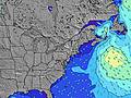 | 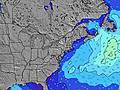 | 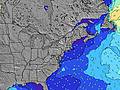 | ||||||||||||
Wave Height (m) Direction Period (s) | SSE 6 | SSE 8 | S 8 | SSE 7 | SSE 7 | SSE 7 | SE 7 | S 7 | SSE 7 | S 6 | SSE 6 | S 6 | S 6 | S 6 | S 6 | S 6 | S 6 | S 6 | SSW 6 |
Wave Graph | |||||||||||||||||||
155 | 299 | 383 | 125 | 59 | 42 | 151 | 276 | 99 | 91 | 48 | 91 | 148 | 74 | 53 | 75 | 52 | 33 | 91 | |
Wind (km/h) | |||||||||||||||||||
Wind State on-shore cross-onshore cross-shore cross-offshore off-shore glassy | cross | cross | cross-off | cross | cross-on | cross-on | cross-on | cross | cross | cross | cross | cross | cross | cross-off | cross | cross-off | cross-off | cross | cross-off |
High Tide | 11:11PM1.27m | 11:41AM1.21m | 11:52PM1.20m | 12:27PM1.25m | 00:39AM1.13m | 1:20PM1.28m | 1:37AM1.06m | 2:22PM1.31m | 2:45AM1.00m | 3:30PM1.35m | 4:01AM0.99m | 4:40PM1.41m | |||||||
Low Tide | 5:37AM0.05m | 5:59PM0.17m | 6:16AM0.06m | 6:54PM0.20m | 7:03AM0.08m | 7:57PM0.21m | 7:56AM0.10m | 9:08PM0.21m | 8:58AM0.10m | 10:19PM0.18m | 10:06AM0.09m | 11:27PM0.12m | |||||||
— | 5:58 | — | — | 6:00 | — | — | 6:01 | — | — | 6:01 | — | — | 6:03 | — | — | 6:03 | — | — | |
8:08 | — | 8:07 | — | — | 8:07 | — | — | 8:06 | — | — | 8:05 | — | — | 8:04 | — | — | 8:01 | — | |
mm | 11 | 8 | 10 | 5 | — | — | 4 | 2 | 2 | 3 | — | — | — | — | — | — | — | — | 15 |
Temp °C | 25 | 25 | 25 | 26 | 24 | 24 | 24 | 24 | 27 | 26 | 27 | 28 | 27 | 29 | 30 | 27 | 28 | 31 | 27 |
Feels °C | 27 | 25 | 26 | 29 | 22 | 22 | 26 | 24 | 29 | 28 | 28 | 28 | 28 | 30 | 30 | 27 | 30 | 32 | 29 |
Swell 1 Height (m) Direction Period (s) | E 6 | — | — | SSE 7 | SSE 7 | SSE 7 | — | SSE 7 | — | — | E 9 | E 9 | — | S 6 | SE 8 | SSE 6 | S 6 | SE 7 | S 6 |
1 | — | — | 125 | 59 | 42 | — | 136 | — | — | 2 | 2 | — | 49 | 9 | 52 | 34 | 19 | 50 | |
Swell 2 Height (m) Direction Period (s) | — | — | — | — | — | SE 7 | — | E 8 | E 10 | — | — | — | — | E 11 | E 10 | E 9 | SE 8 | E 9 | SE 8 |
— | — | — | — | — | 33 | — | 1 | 2 | — | — | — | — | 2 | 2 | 2 | 21 | 1 | 9 | |
Swell 3 Height (m) Direction Period (s) | — | — | — | — | — | E 8 | — | — | E 8 | — | — | — | — | E 11 | — | — | E 9 | — | E 8 |
— | — | — | — | — | 1 | — | — | 1 | — | — | — | — | 2 | — | — | 2 | — | 1 | |
Wind waves Height (m) Direction Period (s) | SSE 6 | SSE 8 | S 8 | — | ENE 4 | E 4 | SE 7 | S 7 | SSE 7 | S 6 | SSE 6 | S 6 | S 6 | S 6 | S 6 | S 6 | S 6 | S 6 | SSW 6 |
155 | 299 | 383 | — | 27 | 26 | 151 | 276 | 99 | 91 | 48 | 91 | 148 | 74 | 53 | 75 | 52 | 33 | 91 | |
Nearest Offshore or Glassy | |||||||||||||||||||
Distance (km) | 1046 | 1214 | 125 | 11 | 182 | 292 | 292 | 73 | 73 | 15 | 125 | 328 | 138 | 111 | 328 | 0 | 0 | 73 | 0 |
Best forecast wave conditions in New Jersey | |||||||||||||||||||
Best forecast wave conditions in United States | |||||||||||||||||||
Header Global | |||||||||||||||||||
- Map Icons:
 Break
Break Live Wave Height (m)
 Live Wind Speed (km/h)
 Surf Rating (10 Max)
 Ocean Swells (m)
- Wind Speed (km/h)
Latest Updates


FREE! Surf-Forecast.com widget for your website
The surf report / weather widget below is available to embed on third party websites free of charge and provides a summary of our Waverly surf forecast. Simply grab the html code snippet that we provide and paste it into your own site. You can choose your preferred language and metric/imperial units for the surf forecast feed to suit users of your site. Click here to get the code.
Information about the Waverly Surf forecast
The above surf forecast table for Waverly provides essential information for determining whether the surfing conditions will be good over the next 16 days. A general guide to surfing at Waverly can be found by selecting the local surf guide option on the grey menu. Our Waverly surf forecast is unique since it includes wave energy (power) that defines the real feel of the surf rather than just the height or the period. If you surf the same spot (Waverly) regularly then make a mental note of the wave energy from the surf forecast table each time you go. Very soon you may start to choose your surf days based on the wave energy alone combined with our forecast of favourable offshore wind conditions. Our star ratings will help here and of course you will also find the usual wave height and period predictions on our surf forecasts as well as a full break down of the swell components under our advanced users option (to reveal that, click the little Einstein character under the tide times).
Further information to help with frequently asked questions about our surf forecast for Waverly may be found under the help tab on the top menu and also by moving your mouse over the question marks on the surf forecast table itself. Please always bear in mind that the forecast is for near-shore open water and local factors at each surf break influence the actual breaking wave height, such as the beach / reef profile, water depths offshore and shelter.
Waverly is 3 km (2 miles) from Ocean City. If you plan a vacation in New Jersey, look for hotels and other accommodation in Ocean City. Ocean City has rooms for a wide range of budgets as well as car hire and transport links.
 Nearest