

Surf Forecasts:

Elwha surf forecast from 2 Aug 2026:
- Best quality surf: Sunday 2 Aug, 11PM (local time) - 3.5ft (1.1m), 8s period, W swell with cross-offshore winds.
- Most powerful swell: Sunday 2 Aug, 2PM (local time) - 4.5ft (1.3m), 9s period, W swell with 275 kJ wave energy.
- Next surfable swell (1★+): Sunday 2 Aug, 11PM (local time) - 3.5ft (1.1m), 8s period with W swell.
Best Forecast Surf Conditions for Elwha this week:
The surf forecast for Elwha over the next 16 days: The first swell (rated 1 star or higher) is forecast to arrive on Sunday (Aug 02) at 11PM. The primary swell is predicted to be 1.1m and 8s period. The wind is predicted to be cross-offshore as the swell arrives.
The most powerful waves expected at Elwha in the next 16 days are 1.3m 9s and forecast to arrive on Sunday (Aug 02) at 2PM. Winds are predicted to be cross-shore at the time the swell arrives. The largest open ocean swell (not directed at the beach) is 0.4m 14s period and expected on Thursday (Aug 06) at 2PM.
| Wave Type | Time (PDT) & Date | Wave Height & Period |
|---|---|---|
| Next good surf (1 star+) | 11PM (Sun 2nd Aug) | 3.5ft (1.1m) 8s |
| Best Surf | 11PM (Sun 2nd Aug) | 3.5ft (1.1m) 8s |
| Most Powerful | 2PM (Sun 2nd Aug) | 4.5ft (1.3m) 9s |
Table - best surf conditions forecast for Elwha over the next 16 days.
The Lowdown
Alright folks, Rusty here. Let me break down what we’ve got for the Elwha region over the next couple of weeks. It’s a quiet stretch ahead, so I’ll be straight with you.
Right now, and for the next few days, conditions are pretty ordinary. The water is sitting at 52°, which is a full 7° colder than usual for this time of year – that’s a real chilly dip, so a thick wetsuit is a must. The first few days show weak swell energy, with combined energy only around 65 to 281, and the waves are small, mostly between 3ft and 4ft, coming from the west or west-northwest. The wind is mostly cross or cross-onshore, keeping things messy. There’s a brief moment of glassy conditions on Tuesday afternoon and Wednesday afternoon, but the waves are still tiny, around 3ft, so it’s barely a bump.
The first real glimmer comes on Thursday morning, August 6th. The wind goes glassy early, and the swell is 3ft from the west-northwest with a period of 8 seconds. The combined energy is a modest 115, but it’s the cleanest we’ll see for a while. Still, the comment says “surfable but very ordinary” – it’s not a standout, just a small window of okay conditions.
After that, it’s back to poor surf through the rest of the first week and into the second. We get a few more glassy mornings, like on August 9th and 11th, but the swell stays small, around 3ft to 3ft. The energy bumps up a bit on August 11th morning, with a combined energy of 173 and glassy wind, but the wave height is just 3ft – not enough to get excited about.
Then, from August 12th into the weekend, the swell drops off even more, down to 2ft, but the period stretches out to 15–16 seconds. That’s a long-period groundswell, but it’s tiny. The combined energy is still moderate, around 155–182, but with such small waves, it’s mostly just a swell on the water. The wind is mostly cross, so it’s not clean either. On August 14th morning, we get glassy conditions again, but again, only 2ft waves.
The very end of the outlook, around August 16th and 17th, shows a bit more energy – combined energy up to 227 on the 16th morning – but the wind is picking up to a gentle or moderate breeze, and the waves are still only 3ft to 4ft, with poor conditions.
Honestly, there’s no real standout session here. The closest thing to a surfable window is the glassy morning on August 6th, but even that’s just small, ordinary waves. For the rest of the 16 days, it’s mostly a blank run. The Elwha is a river mouth, and it’s often inconsistent, so this quiet stretch isn’t too surprising. If you’re desperate, you might get a few tiny, clean waves on a glassy morning, but don’t expect much.
Keep an eye on the forecasts – things can change. But for now, we’re in a flat spell.
Rusty.
Short Range ForecastMostly dry. Warm (max 24°C on Tue afternoon, min 14°C on Sun morning). Wind will be generally light. | Days 4-6 Weather SummaryMostly dry. Warm (max 26°C on Wed afternoon, min 16°C on Thu night). Wind will be generally light. | ||||||||||||||||||||
Sunday 2 | Monday 3 | Tuesday 4 | Wednesday 5 | Thursday 6 | Friday 7 | Saturday 8 | |||||||||||||||
AM | PM | Night | AM | PM | Night | AM | PM | Night | AM | PM | Night | AM | PM | Night | AM | PM | Night | AM | PM | Night | |
Swell Height Map | 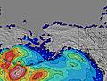 | 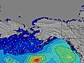 | 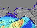 | 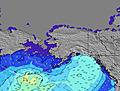 | 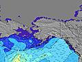 | 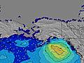 | 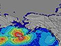 | ||||||||||||||
Wave Height (m) Direction Period (s) | W 9 | W 9 | W 8 | W 7 | W 7 | W 7 | W 7 | W 9 | W 9 | WNW 8 | W 8 | W 8 | WNW 8 | W 8 | W 8 | W 8 | W 7 | W 7 | W 7 | W 7 | W 7 |
Wave Graph | |||||||||||||||||||||
281 | 220 | 144 | 104 | 65 | 46 | 66 | 99 | 96 | 118 | 86 | 86 | 115 | 78 | 74 | 90 | 81 | 92 | 57 | 55 | 70 | |
Wind (km/h) | |||||||||||||||||||||
Wind State on-shore cross-onshore cross-shore cross-offshore off-shore glassy | cross | cross | cross-off | cross | cross-on | glassy | cross | glassy | glassy | cross | glassy | glassy | glassy | cross | cross-off | cross | cross | cross | cross | cross | cross |
High Tide | 6:40PM1.73m | 5:17AM1.36m | 6:52PM1.83m | 6:50AM1.14m | 7:05PM1.96m | 9:17AM1.01m | 7:28PM2.09m | 8:04PM2.20m | 8:56PM2.28m | 10:03PM2.32m | |||||||||||
Low Tide | 11:35AM0.10m | 00:38AM0.89m | 11:55AM0.36m | 1:45AM0.71m | 12:11PM0.62m | 2:57AM0.48m | 12:20PM0.87m | 4:08AM0.23m | 5:14AM-0.03m | 6:13AM-0.27m | |||||||||||
5:50 | — | — | 5:52 | — | — | 5:52 | — | — | 5:54 | — | — | 5:56 | — | — | 5:56 | — | — | 5:58 | — | — | |
— | 8:49 | — | — | 8:46 | — | — | 8:45 | — | — | 8:44 | — | — | 8:43 | — | — | 8:40 | — | — | 8:39 | — | |
mm | — | — | — | — | — | — | — | — | — | — | — | — | — | — | — | — | — | — | — | — | — |
Temp °C | 16 | 17 | 16 | 18 | 22 | 19 | 22 | 24 | 21 | 23 | 26 | 22 | 23 | 24 | 22 | 20 | 22 | 19 | 19 | 21 | 16 |
Feels °C | 14 | 14 | 14 | 16 | 21 | 17 | 20 | 23 | 19 | 21 | 26 | 21 | 23 | 24 | 19 | 18 | 21 | 16 | 18 | 20 | 12 |
Swell 1 Height (m) Direction Period (s) | W 9 | W 9 | W 8 | W 7 | W 7 | W 7 | W 7 | W 9 | W 9 | WNW 8 | W 8 | W 8 | WNW 8 | W 8 | W 8 | W 8 | W 7 | W 7 | W 7 | W 13 | W 7 |
281 | 220 | 144 | 104 | 65 | 46 | 66 | 99 | 96 | 118 | 86 | 86 | 115 | 78 | 74 | 90 | 81 | 92 | 57 | 30 | 70 | |
Swell 2 Height (m) Direction Period (s) | SW 14 | SW 13 | SW 13 | SW 13 | SW 13 | SSW 13 | WSW 16 | WSW 16 | WSW 15 | WSW 15 | WSW 15 | SW 14 | SW 14 | SW 14 | SW 13 | SW 13 | SW 13 | SW 13 | SW 13 | SW 12 | W 12 |
29 | 28 | 28 | 28 | 27 | 17 | 25 | 25 | 23 | 21 | 21 | 31 | 31 | 29 | 28 | 27 | 27 | 27 | 25 | 24 | 26 | |
Swell 3 Height (m) Direction Period (s) | SW 19 | W 19 | SW 18 | WSW 18 | SW 18 | WSW 16 | SW 13 | SW 13 | SW 12 | SW 12 | SW 12 | W 18 | WSW 13 | W 16 | W 13 | W 15 | W 12 | W 13 | W 13 | SW 16 | SW 12 |
15 | 7 | 12 | 31 | 12 | 26 | 7 | 6 | 6 | 6 | 6 | 6 | 18 | 5 | 13 | 17 | 12 | 29 | 14 | 42 | 24 | |
Wind waves Height (m) Direction Period (s) | — | — | — | — | — | — | — | — | — | — | — | — | — | — | — | — | — | — | — | W 7 | — |
— | — | — | — | — | — | — | — | — | — | — | — | — | — | — | — | — | — | — | 55 | — | |
Nearest Offshore or Glassy | |||||||||||||||||||||
Distance (km) | 40 | 1559 | 0 | 51 | 40 | 40 | 51 | 40 | 40 | 51 | 40 | 40 | 0 | 1569 | 56 | 70 | 70 | 56 | 40 | 945 | 70 |
Best forecast wave conditions in Washington State | |||||||||||||||||||||
Best forecast wave conditions in United States | |||||||||||||||||||||
Header Global | |||||||||||||||||||||
- Map Icons:
 Break
Break Live Wave Height (m)
 Live Wind Speed (km/h)
 Surf Rating (10 Max)
 Ocean Swells (m)
- Wind Speed (km/h)
Latest Updates


FREE! Surf-Forecast.com widget for your website
The surf report / weather widget below is available to embed on third party websites free of charge and provides a summary of our Elwha surf forecast. Simply grab the html code snippet that we provide and paste it into your own site. You can choose your preferred language and metric/imperial units for the surf forecast feed to suit users of your site. Click here to get the code.
Information about the Elwha Surf forecast
The above surf forecast table for Elwha provides essential information for determining whether the surfing conditions will be good over the next 16 days. A general guide to surfing at Elwha can be found by selecting the local surf guide option on the grey menu. Our Elwha surf forecast is unique since it includes wave energy (power) that defines the real feel of the surf rather than just the height or the period. If you surf the same spot (Elwha) regularly then make a mental note of the wave energy from the surf forecast table each time you go. Very soon you may start to choose your surf days based on the wave energy alone combined with our forecast of favourable offshore wind conditions. Our star ratings will help here and of course you will also find the usual wave height and period predictions on our surf forecasts as well as a full break down of the swell components under our advanced users option (to reveal that, click the little Einstein character under the tide times).
Further information to help with frequently asked questions about our surf forecast for Elwha may be found under the help tab on the top menu and also by moving your mouse over the question marks on the surf forecast table itself. Please always bear in mind that the forecast is for near-shore open water and local factors at each surf break influence the actual breaking wave height, such as the beach / reef profile, water depths offshore and shelter.
Elwha is 11 km (7 miles) from the city of Port Angeles. If you plan a vacation in Washington State, look for hotels and other accommodation in Port Angeles. Port Angeles has rooms for a wide range of budgets as well as car hire and transport links.
 Nearest