

Surf Forecasts:

Jordan River surf forecast from 14 Jul 2026:
- Best quality surf: Sunday 19 Jul, 5AM (local time) - 1.5ft (0.4m), 18s period, SW swell with glassy winds.
- Most powerful swell: Friday 17 Jul, 11AM (local time) - 2.5ft (0.7m), 16s period, W swell with 249 kJ wave energy.
- Next surfable swell (1★+): Tuesday 14 Jul, 8AM (local time) - 1.5ft (0.4m), 14s period with W swell.
Best Forecast Surf Conditions for Jordan River this week:
The surf forecast for Jordan River over the next 16 days: The first swell (rated 1 star or higher) is forecast to arrive on Tuesday (Jul 14) at 8AM. The primary swell is predicted to be 0.4m and 14s period with a secondary swell of 0.4m and 5s. The wind is predicted to be glassy as the swell arrives.
The most powerful waves expected at Jordan River in the next 16 days are 0.7m 16s and forecast to arrive on Friday (Jul 17) at 11AM. Winds are predicted to be cross-shore at the time the swell arrives.
| Wave Type | Time (PDT) & Date | Wave Height & Period |
|---|---|---|
| Next good surf (1 star+) | 8AM (Tue 14th Jul) | 1.5ft (0.4m) 14s |
| Best Surf | 5AM (Sun 19th Jul) | 1.5ft (0.4m) 18s |
| Most Powerful | 11AM (Fri 17th Jul) | 2.5ft (0.7m) 16s |
Table - best surf conditions forecast for Jordan River over the next 16 days.
The Lowdown
Alright folks, Rusty here. Let's check out what Jordan River has cooking over the next couple weeks.
The first part of the forecast is pretty flat and sleepy, but we've got a couple of mornings shaping up real nice in the middle and end. The two sessions to mark on the calendar are Monday 20th and Saturday 25th mornings.
Starting Monday 13th – tiny. 1ft swell from the southwest with a long 14-second period. The water is cold, about 52°, a solid 6° colder than normal. Combined energy is weak (118). The wind is glassy, so the surface is clean, but you’re barely moving out there.
Tuesday 14th is more of the same – 1ft, glass, weak energy. By the afternoon, a cross-shore breeze kicks up and makes a mess of it. Wednesday 15th shows a little 2ft in the morning under glassy conditions, but that’s about the best early on. Wednesday afternoon and Thursday both cross-shore and small. Thursday afternoon has rain and a 12 mph cross-shore – sloppy. Friday and Saturday mornings stay small and crossed up.
Sunday 19th morning is the first real session – glassy, calm, with a clean 3ft swell from the west, 8-second period. Energy jumps to 233. Decent beginner-friendly size. The wind holds in the morning, but it goes onshore by the afternoon.
Monday 20th morning – this is the highlight. Glassy as can be, a light southeast breeze at 3 mph. Swell is 4ft from the west, 9-second period, and the energy hits 327 – solid moderate. Expect clean, smooth waves with a nice little push. Crowds can show up here *sometimes*, so get out early for the best of it.
Tuesday 21st through Friday 24th mornings are mostly glassy but smaller – 2ft to 3ft, and the energy drops.
Saturday 25th morning – another winner. Glassy calm with a light south-southwest breeze. Swell builds to 4ft from the west, 9-second period, and energy hits 329 – the best of the longer-range outlook. Expect good conditions, clean faces, and a bit more size. The afternoon will get cross-shore and choppy, but that morning session is the one to chase.
The final few days, Sunday 26th to Tuesday 28th, are rideable but not special – 3ft to 3ft with glassy starts that get broken up by afternoon winds.
So my take: the first week is mostly a bust, aside from Sunday 19th. The clear standouts are Monday 20th and Saturday 25th – both offer clean, waist-to-chest high glass and moderate energy. Those are your days.
– Rusty
Short Range ForecastMostly dry. Warm (max 23°C on Wed afternoon, min 15°C on Mon night). Wind will be generally light. | Days 5-7 Weather SummaryMostly dry. Warm (max 20°C on Sun afternoon, min 13°C on Fri night). Wind will be generally light. | ||||||||||||||||||||
Tuesday 14 | Wednesday 15 | Thursday 16 | Friday 17 | Saturday 18 | Sunday 19 | Mon 20 | |||||||||||||||
Night | AM | PM | Night | AM | PM | Night | AM | PM | Night | AM | PM | Night | AM | PM | Night | AM | PM | Night | AM | PM | |
Swell Height Map | 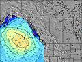 | 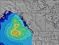 | 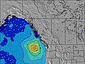 | 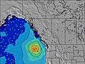 | 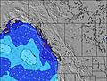 | 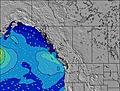 | 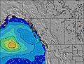 | 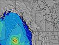 | |||||||||||||
Wave Height (m) Direction Period (s) | SW 14 | W 14 | W 9 | W 9 | W 9 | W 9 | W 18 | W 18 | W 17 | W 16 | W 16 | W 16 | WNW 10 | W 15 | W 15 | W 15 | W 8 | W 8 | W 9 | W 9 | WNW 9 |
Wave Graph | |||||||||||||||||||||
29 | 64 | 78 | 78 | 83 | 60 | 101 | 96 | 140 | 192 | 249 | 176 | 136 | 113 | 112 | 107 | 130 | 103 | 181 | 158 | 123 | |
Wind (km/h) | |||||||||||||||||||||
Wind State on-shore cross-onshore cross-shore cross-offshore off-shore glassy | glassy | glassy | cross | cross | glassy | cross | glassy | cross-off | cross | cross | cross | cross | cross | cross | cross | cross | glassy | glassy | glassy | glassy | cross |
High Tide | 00:08AM3.35m | 4:38PM2.36m | 1:03AM3.26m | 4:53PM2.41m | 1:55AM3.10m | 5:19PM2.48m | 2:47AM2.87m | 5:49PM2.58m | 3:40AM2.60m | 6:20PM2.68m | 4:42AM2.30m | 6:51PM2.77m | 6:20AM2.02m | 7:22PM2.83m | |||||||
Low Tide | 8:37AM0.03m | 6:47PM2.33m | 9:17AM0.09m | 8:19PM2.25m | 9:55AM0.25m | 9:33PM2.15m | 10:30AM0.50m | 10:45PM2.04m | 11:01AM0.80m | 00:01AM1.92m | 11:26AM1.12m | 1:22AM1.77m | 11:39AM1.44m | ||||||||
— | 5:28 | — | — | 5:30 | — | — | 5:31 | — | — | 5:31 | — | — | 5:33 | — | — | 5:33 | — | — | 5:35 | — | |
9:14 | — | — | 9:13 | — | — | 9:12 | — | — | 9:12 | — | — | 9:10 | — | — | 9:09 | — | — | 9:08 | — | 9:07 | |
mm | — | — | — | — | — | — | — | — | — | — | — | — | — | — | — | — | — | — | — | — | — |
Temp °C | 17 | 20 | 21 | 19 | 21 | 23 | 20 | 23 | 23 | 18 | 18 | 19 | 16 | 17 | 19 | 17 | 18 | 20 | 17 | 21 | 23 |
Feels °C | 16 | 19 | 19 | 17 | 21 | 22 | 19 | 22 | 22 | 15 | 16 | 16 | 13 | 15 | 17 | 15 | 18 | 20 | 17 | 21 | 24 |
Swell 1 Height (m) Direction Period (s) | W 4 | W 10 | W 9 | W 9 | W 9 | W 9 | W 9 | W 8 | W 8 | W 8 | W 8 | W 8 | WNW 10 | W 10 | W 15 | W 9 | W 8 | W 8 | W 9 | W 9 | WNW 9 |
6 | 30 | 78 | 78 | 83 | 59 | 54 | 68 | 63 | 82 | 60 | 48 | 136 | 92 | 112 | 78 | 130 | 103 | 181 | 158 | 123 | |
Swell 2 Height (m) Direction Period (s) | WNW 8 | W 5 | W 13 | W 13 | W 13 | W 13 | W 18 | W 18 | W 17 | W 16 | W 16 | W 16 | W 16 | W 15 | SW 14 | W 15 | W 14 | W 14 | SW 16 | SW 17 | SW 17 |
11 | 8 | 32 | 32 | 32 | 29 | 101 | 96 | 140 | 192 | 249 | 176 | 119 | 113 | 33 | 107 | 65 | 64 | 64 | 106 | 73 | |
Swell 3 Height (m) Direction Period (s) | SW 14 | W 14 | SW 13 | SW 13 | WSW 18 | W 18 | W 12 | W 12 | SW 16 | SW 16 | SW 16 | WNW 11 | SW 14 | SW 14 | SW 18 | SW 17 | SW 18 | WSW 13 | W 14 | W 13 | W 13 |
29 | 64 | 27 | 27 | 30 | 60 | 28 | 11 | 40 | 40 | 39 | 43 | 33 | 33 | 12 | 107 | 51 | 18 | 35 | 14 | 14 | |
Wind waves Height (m) Direction Period (s) | — | — | — | — | — | — | — | — | — | — | — | — | — | — | W 9 | — | — | — | — | — | — |
— | — | — | — | — | — | — | — | — | — | — | — | — | — | 110 | — | — | — | — | — | — | |
Nearest Offshore or Glassy | |||||||||||||||||||||
Distance (km) | 53 | 0 | 931 | 17 | 0 | 1281 | 0 | 0 | 39 | 17 | 39 | 49 | 17 | 24 | 931 | 17 | 0 | 0 | 0 | 0 | 931 |
Best forecast wave conditions in Vancouver Island | |||||||||||||||||||||
Best forecast wave conditions in Canada | |||||||||||||||||||||
Header Global | |||||||||||||||||||||
- Map Icons:
 Break
Break Live Wave Height (m)
 Live Wind Speed (km/h)
 Surf Rating (10 Max)
 Ocean Swells (m)
- Wind Speed (km/h)


FREE! Surf-Forecast.com widget for your website
The surf report / weather widget below is available to embed on third party websites free of charge and provides a summary of our Jordan River surf forecast. Simply grab the html code snippet that we provide and paste it into your own site. You can choose your preferred language and metric/imperial units for the surf forecast feed to suit users of your site. Click here to get the code.
Information about the Jordan River Surf forecast
The above surf forecast table for Jordan River provides essential information for determining whether the surfing conditions will be good over the next 16 days. A general guide to surfing at Jordan River can be found by selecting the local surf guide option on the grey menu. Our Jordan River surf forecast is unique since it includes wave energy (power) that defines the real feel of the surf rather than just the height or the period. If you surf the same spot (Jordan River) regularly then make a mental note of the wave energy from the surf forecast table each time you go. Very soon you may start to choose your surf days based on the wave energy alone combined with our forecast of favourable offshore wind conditions. Our star ratings will help here and of course you will also find the usual wave height and period predictions on our surf forecasts as well as a full break down of the swell components under our advanced users option (to reveal that, click the little Einstein character under the tide times).
Further information to help with frequently asked questions about our surf forecast for Jordan River may be found under the help tab on the top menu and also by moving your mouse over the question marks on the surf forecast table itself. Please always bear in mind that the forecast is for near-shore open water and local factors at each surf break influence the actual breaking wave height, such as the beach / reef profile, water depths offshore and shelter.
Jordan River is 43 km (27 miles) from the city of Victoria. If you plan a holiday in Vancouver Island, look for hotels and other accommodation in Victoria. Victoria has rooms for a wide range of budgets as well as car hire and transport links.
 Nearest