

Surf Forecasts:

Jennette's Pier surf forecast from 3 Aug 2026:
- Best quality surf: Tuesday 4 Aug, 8AM (local time) - 3ft (0.9m), 8s period, SE swell with cross-offshore winds.
- Most powerful swell: Monday 3 Aug, 2PM (local time) - 3.5ft (1.1m), 8s period, SE swell with 128 kJ wave energy.
- Next surfable swell (1★+): Tuesday 4 Aug, 8AM (local time) - 3ft (0.9m), 8s period with SE swell.
Best Forecast Surf Conditions for Jennette's Pier this week:
The surf forecast for Jennette's Pier over the next 16 days: The first swell (rated 1 star or higher) is forecast to arrive on Tuesday (Aug 04) at 8AM. The primary swell is predicted to be 0.9m and 8s period. The wind is predicted to be cross-offshore as the swell arrives.
The most powerful waves expected at Jennette's Pier in the next 16 days are 1.1m 8s and forecast to arrive on Monday (Aug 03) at 2PM. Winds are predicted to be cross-offshore at the time the swell arrives. The largest open ocean swell (not directed at the beach) is 1.6m 8s period and expected on Monday (Aug 03) at 5AM.
| Wave Type | Time (EDT) & Date | Wave Height & Period |
|---|---|---|
| Next good surf (1 star+) | 8AM (Tue 4th Aug) | 3ft (0.9m) 8s |
| Best Surf | 8AM (Tue 4th Aug) | 3ft (0.9m) 8s |
| Most Powerful | 2PM (Mon 3rd Aug) | 3.5ft (1.1m) 8s |
Table - best surf conditions forecast for Jennette's Pier over the next 16 days.
The Lowdown
Alright folks, Rusty here. Let's be straight with you – the next couple of weeks are looking pretty flat and quiet around Jennette's Pier. The water temp is about average for this time of year, so no surprises there.
We're looking at a long stretch of nothing much. From now through the end of the first week, the swell is tiny, barely scraping 3ft to 3ft on the best days, and even then the periods are short, around 6 to 8 seconds, with combined wave energy barely cracking 105 (moderate energy) at its peak. The wind is mostly cross or cross-off with a moderate to fresh breeze, so the surface won't be totally clean. It's honestly a tough run for paddle surfing.
There's a tiny glimmer on Saturday morning, the 8th of August. The swell is still only 2ft from the ESE at 8 seconds, with a combined energy of 51 (weak). The wind will be light from the SW, so it'll be clean, but the waves are just too small to get excited about.
After that, it drops off even more. From the 9th of August right through to the 17th of August, we're looking at swell heights of 0.7ft to 2ft, with periods mostly below 9 seconds and energy levels in the teens or twenties (very weak). The wind does go offshore on Tuesday the 11th and Wednesday the 12th, with a moderate breeze, but there's just no wave energy to work with.
The only real pulse in the whole 16-day window shows up on Monday the 17th of August. The swell bumps up to 2ft from the SE with a 9-second period, and combined energy jumps to 55 (weak). It's still not great, and the wind is onshore from the ENE, so it'll be choppy. There's nothing here that stands out as a worthwhile session. It's a long, dry spell, and honestly, the setup looks more interesting for kite surfing than paddle surfing right now.
Rusty.
Short Range ForecastHeavy rain (total 53mm), heaviest during Mon afternoon. Warm (max 27°C on Sun night, min 24°C on Mon morning). Winds decreasing (strong winds from the SSW on Sun night, light winds from the SSW by Tue morning). | Days 5-7 Weather SummaryLight rain (total 7mm), mostly falling on Wed night. Warm (max 29°C on Thu afternoon, min 26°C on Wed night). Wind will be generally light. | ||||||||||||||||||
Monday 3 | Tuesday 4 | Wednesday 5 | Thursday 6 | Friday 7 | Saturday 8 | ||||||||||||||
Night | AM | PM | Night | AM | PM | Night | AM | PM | Night | AM | PM | Night | AM | PM | Night | AM | PM | Night | |
Swell Height Map |  | 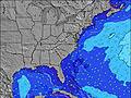 | 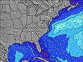 | 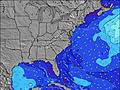 | 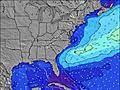 | 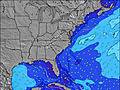 | 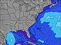 | ||||||||||||
Wave Height (m) Direction Period (s) | SE 8 | E 13 | SE 7 | E 13 | SE 8 | SE 7 | SE 7 | SE 6 | SE 6 | SE 6 | S 6 | S 4 | S 4 | SE 6 | SE 7 | ESE 8 | SE 8 | ESE 8 | ESE 7 |
Wave Graph | |||||||||||||||||||
112 | 3 | 105 | 4 | 88 | 86 | 62 | 47 | 34 | 32 | 26 | 18 | 14 | 25 | 27 | 44 | 49 | 41 | 21 | |
Wind (km/h) | |||||||||||||||||||
Wind State on-shore cross-onshore cross-shore cross-offshore off-shore glassy | cross-off | cross-off | cross-off | cross-off | cross | cross-off | cross-off | cross-off | cross | cross-off | cross-off | cross | cross-off | cross-off | cross | cross-off | cross-off | cross-off | cross-off |
High Tide | 10:39PM1.07m | 11:09AM1.14m | 11:23PM1.02m | 11:55AM1.16m | 00:13AM0.96m | 12:49PM1.16m | 1:10AM0.91m | 1:50PM1.17m | 2:15AM0.88m | 2:58PM1.18m | 3:26AM0.88m | 4:08PM1.20m | 4:37AM0.91m | ||||||
Low Tide | 4:56AM0.07m | 5:32PM0.16m | 5:37AM0.08m | 6:27PM0.18m | 6:23AM0.09m | 7:28PM0.20m | 7:18AM0.10m | 8:36PM0.20m | 8:22AM0.10m | 9:47PM0.18m | 9:31AM0.09m | 10:55PM0.13m | |||||||
— | 6:11 | — | — | 6:11 | — | — | 6:11 | — | — | 6:13 | — | — | 6:13 | — | — | 6:15 | — | — | |
8:06 | — | 8:05 | — | — | 8:04 | — | — | 8:02 | — | — | 8:01 | — | — | 8:00 | — | — | 8:00 | — | |
mm | 3 | 7 | 11 | 7 | 6 | 5 | 10 | 4 | — | 3 | 1 | — | 3 | — | — | — | — | — | — |
Temp °C | 27 | 26 | 25 | 25 | 25 | 25 | 26 | 26 | 27 | 27 | 28 | 29 | 27 | 28 | 29 | 27 | 27 | 28 | 26 |
Feels °C | 25 | 24 | 24 | 25 | 28 | 25 | 26 | 26 | 29 | 29 | 31 | 29 | 27 | 31 | 31 | 27 | 29 | 29 | 26 |
Swell 1 Height (m) Direction Period (s) | SE 8 | E 13 | SE 7 | SSE 7 | SE 8 | SE 7 | SE 7 | SE 6 | SE 6 | SE 6 | ESE 7 | SE 7 | SE 6 | SE 6 | SE 7 | ESE 8 | SE 8 | ESE 8 | ESE 7 |
112 | 3 | 105 | 114 | 88 | 86 | 62 | 47 | 34 | 32 | 26 | 11 | 10 | 25 | 27 | 44 | 49 | 41 | 21 | |
Swell 2 Height (m) Direction Period (s) | — | — | — | E 13 | E 14 | E 12 | E 12 | — | — | E 10 | E 10 | E 10 | ENE 9 | ENE 9 | ENE 9 | NE 9 | E 9 | E 9 | E 9 |
— | — | — | 4 | 4 | 3 | 3 | — | — | 2 | 8 | 8 | 9 | 8 | 8 | 3 | 2 | 2 | 1 | |
Swell 3 Height (m) Direction Period (s) | — | — | — | — | — | E 12 | — | E 12 | E 9 | E 13 | — | E 13 | — | E 11 | — | — | — | — | — |
— | — | — | — | — | 3 | — | 3 | 2 | 3 | — | 3 | — | 2 | — | — | — | — | — | |
Wind waves Height (m) Direction Period (s) | SSE 8 | SSE 8 | SSW 4 | SSW 4 | — | SSW 3 | SSW 4 | SW 3 | SSW 2 | S 4 | S 6 | S 4 | S 4 | WSW 3 | S 4 | S 4 | SW 3 | S 4 | S 4 |
385 | 270 | 25 | 2 | — | 4 | 12 | 2 | 1 | 10 | 24 | 18 | 14 | 1 | 9 | 9 | 1 | 12 | 14 | |
Nearest Offshore or Glassy | |||||||||||||||||||
Distance (km) | 815 | 856 | 508 | 99 | 237 | 99 | 116 | 116 | 296 | 371 | 5 | 687 | 522 | 495 | 687 | 313 | 0 | 320 | 99 |
Best forecast wave conditions in North Carolina | |||||||||||||||||||
Best forecast wave conditions in United States | |||||||||||||||||||
Header Global | |||||||||||||||||||
- Map Icons:
 Break
Break Live Wave Height (m)
 Live Wind Speed (km/h)
 Surf Rating (10 Max)
 Ocean Swells (m)
- Wind Speed (km/h)
Latest Updates


FREE! Surf-Forecast.com widget for your website
The surf report / weather widget below is available to embed on third party websites free of charge and provides a summary of our Jennette's Pier surf forecast. Simply grab the html code snippet that we provide and paste it into your own site. You can choose your preferred language and metric/imperial units for the surf forecast feed to suit users of your site. Click here to get the code.
Information about the Jennette's Pier Surf forecast
The above surf forecast table for Jennette's Pier provides essential information for determining whether the surfing conditions will be good over the next 16 days. A general guide to surfing at Jennette's Pier can be found by selecting the local surf guide option on the grey menu. Our Jennette's Pier surf forecast is unique since it includes wave energy (power) that defines the real feel of the surf rather than just the height or the period. If you surf the same spot (Jennette's Pier) regularly then make a mental note of the wave energy from the surf forecast table each time you go. Very soon you may start to choose your surf days based on the wave energy alone combined with our forecast of favourable offshore wind conditions. Our star ratings will help here and of course you will also find the usual wave height and period predictions on our surf forecasts as well as a full break down of the swell components under our advanced users option (to reveal that, click the little Einstein character under the tide times).
Further information to help with frequently asked questions about our surf forecast for Jennette's Pier may be found under the help tab on the top menu and also by moving your mouse over the question marks on the surf forecast table itself. Please always bear in mind that the forecast is for near-shore open water and local factors at each surf break influence the actual breaking wave height, such as the beach / reef profile, water depths offshore and shelter.
Are you planning a vacation in North Carolina? If you are looking for accommodation near Jennette's Pier, camping, hotels and condos and appartments in North Carolina, consider staying in Elizabeth City which is 70 km (43 miles) away. Alternatively, find information about places to stay and car hire in Cape Hatteras which is 78 km (48 miles) away
 Nearest