

Surf Forecasts:

K.O.A surf forecast from 5 Jul 2026:
- Best quality surf: Tuesday 7 Jul, 8PM (local time) - 2ft (0.6m), 9s period, ESE swell with offshore winds.
- Most powerful swell: Tuesday 7 Jul, 8PM (local time) - 2ft (0.6m), 9s period, ESE swell with 56 kJ wave energy.
- Next surfable swell (1★+): Tuesday 7 Jul, 8PM (local time) - 2ft (0.6m), 9s period with ESE swell.
Best Forecast Surf Conditions for K.O.A this week:
The surf forecast for K.O.A over the next 16 days: The first swell (rated 1 star or higher) is forecast to arrive on Tuesday (Jul 07) at 8PM. The primary swell is predicted to be 0.6m and 9s period with a secondary swell of 0.2m and 6s. The wind is predicted to be offshore as the swell arrives.
The most powerful waves expected at K.O.A in the next 16 days are 0.6m 9s and forecast to arrive on Tuesday (Jul 07) at 8PM. Winds are predicted to be offshore at the time the swell arrives. The largest open ocean swell (not directed at the beach) is 2.4m 7s period and expected on Friday (Jul 10) at 5PM.
| Wave Type | Time (EDT) & Date | Wave Height & Period |
|---|---|---|
| Next good surf (1 star+) | 8PM (Tue 7th Jul) | 2ft (0.6m) 9s |
| Best Surf | 8PM (Tue 7th Jul) | 2ft (0.6m) 9s |
| Most Powerful | 8PM (Tue 7th Jul) | 2ft (0.6m) 9s |
Table - best surf conditions forecast for K.O.A over the next 16 days.
Updates in hr min s Forecast update imminent
Alright, let me break this down for you. The outlook for K.O.A. over the next couple of weeks is a bit of a slow burn. We’ve got a long stretch of nothing much at the start—four days of flat, windy, or just plain messy conditions from the 4th to the 7th of July. The water temperature is sitting at 79°F, which is pretty much normal for this time of year, so no surprises there.
Then on the morning of Wednesday, 8th July, we finally see a tiny pulse of swell—2 ft from the ESE, with a light offshore wind from the WSW. The waves are surfable but honestly, it’s ordinary. The energy is weak (57), so don’t expect much. That little window closes fast, and we’re back to poor conditions through the 9th, 10th, and 11th.
The real action starts to show up on the 12th. Sunday morning the 12th has a small 1 ft SE swell with light offshore wind, but it’s still just ordinary. The afternoon brings a jump in size—5 ft from the NNE—but the period is only 6 seconds, so it’s choppy and messy. That’s more of a kite surfing setup than a paddle session.
Now, the standout days are Monday 13th and Tuesday 14th July. Monday morning you’ve got 6 ft of NE swell, which is right in the optimum direction for this spot. The wind is glassy—dead calm—so the surface will be clean as a whistle. The swell energy is moderate (420), and the waves will have some punch. The period is only 7 seconds, so it’s a short-period swell, meaning it’ll be a bit crumbly, but with that offshore glass, it’ll still be fun for intermediate surfers. It’s a bit big for beginners though. Tuesday morning the 14th is another good one: 5 ft from the ENE, again with offshore wind (WSW 6 mph), and the energy is solid (301). The period is 8 seconds, so a little more shape. Both these mornings are the best on offer.
After that, the swell drops off fast. The 15th has some leftover 3 ft ENE swell but the wind turns cross-off, and by the 16th it’s back to tiny, wind-affected junk. The rest of the forecast through the 19th is just poor conditions with no real surf.
So if you’re looking to get wet, aim for Monday 13th and Tuesday 14th July mornings. The glassy conditions and decent swell direction make those the clear winners. The crowds can be an issue at K.O.A. sometimes, but on a Monday and Tuesday it might be a bit quieter. Keep an eye on the long-range—it’s not a classic run, but these two days are worth the wait.
Rusty
Short Range ForecastHeavy rain (total 20mm), heaviest during Mon night. Warm (max 29°C on Mon night, min 26°C on Sat night). Mainly fresh winds. | Days 5-7 Weather SummaryHeavy rain (total 69mm), heaviest during Tue night. Warm (max 30°C on Wed afternoon, min 24°C on Tue night). Winds increasing (light winds from the NNE on Wed night, strong winds from the SW by Thu night). | ||||||||||||||||||||
Sat 4 | Sunday 5 | Monday 6 | Tuesday 7 | Wednesday 8 | Thursday 9 | Friday 10 | |||||||||||||||
PM | Night | AM | PM | Night | AM | PM | Night | AM | PM | Night | AM | PM | Night | AM | PM | Night | AM | PM | Night | AM | |
Swell Height Map | 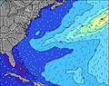 | 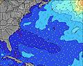 | 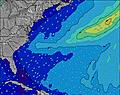 | 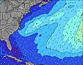 | 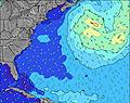 | 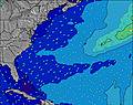 | 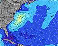 | 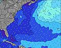 | |||||||||||||
Wave Height (m) Direction Period (s) | ESE 9 | ESE 8 | ESE 8 | ESE 8 | ESE 9 | ESE 9 | ESE 9 | ESE 10 | ESE 10 | SE 9 | SE 9 | ESE 9 | ESE 9 | ESE 9 | ESE 9 | ESE 9 | E 11 | SE 10 | SE 9 | SE 9 | ESE 10 |
Wave Graph | |||||||||||||||||||||
42 | 28 | 27 | 27 | 29 | 33 | 34 | 38 | 36 | 42 | 41 | 56 | 49 | 48 | 31 | 29 | 11 | 24 | 22 | 22 | 9 | |
Wind (km/h) | |||||||||||||||||||||
Wind State on-shore cross-onshore cross-shore cross-offshore off-shore glassy | cross-off | cross-off | cross-off | cross-off | cross-off | cross-off | cross-off | cross-off | cross-off | off | cross-off | off | cross-off | cross | on | cross | cross-off | cross-off | cross-off | cross-off | cross-off |
High Tide | 2:10AM0.22m | 2:53PM0.18m | 2:44AM0.22m | 3:59PM0.19m | 3:22AM0.22m | 5:09PM0.19m | 4:03AM0.22m | 6:13PM0.20m | 4:53AM0.22m | 7:07PM0.21m | 5:52AM0.21m | 7:56PM0.21m | 7:01AM0.20m | ||||||||
Low Tide | 8:10PM0.10m | 9:48AM0.10m | 8:37PM0.11m | 9:49AM0.09m | 9:13PM0.12m | 10:11AM0.07m | 9:55PM0.12m | 10:49AM0.06m | 10:42PM0.13m | 11:32AM0.06m | 11:35PM0.14m | 12:21PM0.07m | 00:34AM0.13m | 1:17PM0.08m | |||||||
— | — | 5:50 | — | — | 5:52 | — | — | 5:52 | — | — | 5:52 | — | — | 5:52 | — | — | 5:54 | — | — | 5:54 | |
8:21 | — | — | 8:20 | — | — | 8:20 | — | — | 8:20 | — | — | 8:20 | — | — | 8:19 | — | — | 8:19 | — | 8:19 | |
mm | — | — | — | — | 1 | 2 | 1 | 14 | 2 | 6 | 46 | 3 | 9 | 1 | — | — | 4 | — | — | — | — |
Temp °C | 28 | 27 | 27 | 28 | 27 | 28 | 28 | 29 | 28 | 29 | 26 | 27 | 30 | 29 | 25 | 27 | 29 | 28 | 29 | 28 | 29 |
Feels °C | 28 | 27 | 29 | 29 | 27 | 28 | 27 | 28 | 27 | 28 | 27 | 28 | 31 | 31 | 28 | 30 | 28 | 28 | 28 | 25 | 28 |
Swell 1 Height (m) Direction Period (s) | ESE 9 | ESE 8 | ESE 8 | ESE 8 | ESE 9 | ESE 9 | ESE 9 | ESE 10 | ESE 10 | SE 9 | S 7 | S 7 | ESE 9 | ESE 9 | S 7 | ESE 9 | E 11 | SE 10 | SE 9 | SE 9 | S 7 |
42 | 28 | 27 | 27 | 29 | 33 | 34 | 38 | 36 | 42 | 247 | 157 | 49 | 48 | 94 | 29 | 9 | 24 | 22 | 22 | 246 | |
Swell 2 Height (m) Direction Period (s) | E 7 | E 6 | — | E 8 | E 7 | E 7 | — | E 11 | NE 7 | NNE 6 | SE 9 | ESE 9 | NE 7 | E 12 | ESE 9 | E 11 | ENE 11 | E 10 | E 10 | E 10 | ESE 10 |
1 | 1 | — | 1 | 1 | 1 | — | 2 | 2 | 4 | 41 | 56 | 2 | 3 | 31 | 2 | 11 | 8 | 2 | 2 | 9 | |
Swell 3 Height (m) Direction Period (s) | — | — | — | — | — | — | — | — | NE 7 | E 10 | NE 6 | NE 6 | E 12 | E 11 | E 11 | NE 6 | — | — | — | — | E 9 |
— | — | — | — | — | — | — | — | 2 | 2 | 1 | 1 | 3 | 2 | 2 | 1 | — | — | — | — | 2 | |
Wind waves Height (m) Direction Period (s) | SSW 3 | SSW 4 | SSW 4 | S 3 | S 4 | S 5 | S 5 | S 6 | S 6 | S 7 | SSW 7 | SSW 7 | S 7 | S 7 | — | S 7 | S 7 | S 7 | SSW 7 | SSW 7 | SSW 7 |
4 | 16 | 5 | 8 | 17 | 27 | 52 | 116 | 188 | 196 | 330 | 210 | 154 | 152 | — | 142 | 447 | 285 | 579 | 529 | 349 | |
Nearest Offshore or Glassy | |||||||||||||||||||||
Distance (km) | 2696 | 299 | 1436 | 2725 | 310 | 1843 | 2167 | 50 | 68 | 264 | 147 | 0 | 39 | 21 | 261 | 533 | 523 | 68 | 342 | 145 | 39 |
Best forecast wave conditions in North Carolina | |||||||||||||||||||||
Best forecast wave conditions in United States | |||||||||||||||||||||
Header Global | |||||||||||||||||||||
- Map Icons:
 Break
Break Live Wave Height (m)
 Live Wind Speed (km/h)
 Surf Rating (10 Max)
 Ocean Swells (m)
- Wind Speed (km/h)


FREE! Surf-Forecast.com widget for your website
The surf report / weather widget below is available to embed on third party websites free of charge and provides a summary of our K.O.A surf forecast. Simply grab the html code snippet that we provide and paste it into your own site. You can choose your preferred language and metric/imperial units for the surf forecast feed to suit users of your site. Click here to get the code.
Information about the K.O.A Surf forecast
The above surf forecast table for K.O.A provides essential information for determining whether the surfing conditions will be good over the next 16 days. A general guide to surfing at K.O.A can be found by selecting the local surf guide option on the grey menu. Our K.O.A surf forecast is unique since it includes wave energy (power) that defines the real feel of the surf rather than just the height or the period. If you surf the same spot (K.O.A) regularly then make a mental note of the wave energy from the surf forecast table each time you go. Very soon you may start to choose your surf days based on the wave energy alone combined with our forecast of favourable offshore wind conditions. Our star ratings will help here and of course you will also find the usual wave height and period predictions on our surf forecasts as well as a full break down of the swell components under our advanced users option (to reveal that, click the little Einstein character under the tide times).
Further information to help with frequently asked questions about our surf forecast for K.O.A may be found under the help tab on the top menu and also by moving your mouse over the question marks on the surf forecast table itself. Please always bear in mind that the forecast is for near-shore open water and local factors at each surf break influence the actual breaking wave height, such as the beach / reef profile, water depths offshore and shelter.
Are you planning a vacation in North Carolina? If you are looking for accommodation near K.O.A, camping, hotels and condos and appartments in North Carolina, consider staying in Cape Hatteras which is 40 km (25 miles) away.
 Nearest