

Surf Forecasts:

Lebu surf forecast from 9 Jul 2026:
- Best quality surf: Thursday 9 Jul, 2AM (local time) - 7ft (2.2m), 14s period, SW swell with glassy winds.
- Most powerful swell: Monday 13 Jul, 11PM (local time) - 13ft (4.0m), 15s period, W swell with 6,932 kJ wave energy.
- Next surfable swell (1★+): Thursday 9 Jul, 2AM (local time) - 7ft (2.2m), 14s period with SW swell.
Best Forecast Surf Conditions for Lebu this week:
The surf forecast for Lebu over the next 16 days: The first swell (rated 1 star or higher) is forecast to arrive on Thursday (Jul 09) at 2AM. The primary swell is predicted to be 2.2m and 14s period with a secondary swell of 2.4m and 11s. The wind is predicted to be glassy as the swell arrives.
The most powerful waves expected at Lebu in the next 16 days are 4.0m 15s and forecast to arrive on Monday (Jul 13) at 11PM. Winds are predicted to be onshore at the time the swell arrives. The largest open ocean swell (not directed at the beach) is 0.6m 4s period and expected on Sunday (Jul 12) at 2AM.
| Wave Type | Time (-04) & Date | Wave Height & Period |
|---|---|---|
| Next good surf (1 star+) | 2AM (Thu 9th Jul) | 7ft (2.2m) 14s |
| Best Surf | 2AM (Thu 9th Jul) | 7ft (2.2m) 14s |
| Most Powerful | 11PM (Mon 13th Jul) | 13ft (4.0m) 15s |
Table - best surf conditions forecast for Lebu over the next 16 days.
Alright folks, Rusty here. Let’s get straight into what’s on offer for the next couple of weeks at Lebu. This is a reef setup that’s known for handling some serious power, and it’s looking like a classic run of good and not-so-good.
The kick-off is Thursday morning, July 9th, with a solid 8ft swell from the SW, and a light 6 mph SE breeze coming straight offshore. That’s the kind of clean, lined-up stuff that gets the heart pumping. The energy is strong, reading 3370, and the 14-second period means there’s plenty of grunt in the water. This is expert territory though – too big for the learners. The afternoon goes glassy, zero wind, still a solid 8ft, and the energy stays high (2544). It’s a beautiful, clean start.
Friday the 10th is a write-off. The wind swings onshore, pushing the swell into a messy heap. Don’t even bother.
Saturday morning, July 11th, brings a clean-up. The wind is back offshore from the S at 12 mph, the swell is a punchy 7ft from the SSW, with a 14-second period and 1899 in energy. The sets will have some real power. The afternoon is a little less clean with a cross-offshore wind, but still rideable.
Sunday the 12th is a gem. Glassy conditions in the morning, zero wind, a nice 6ft SSW swell, and the energy is a healthy 1047. It’ll be clean and inviting. The afternoon stays clean with a cross-offshore breeze.
Then we hit a rough patch. From Monday the 13th through to the end of the third week of July, the wind is a nightmare. Onshore or strong cross-onshore winds blow out almost everything. There’s a massive 12ft to 13ft swell running mid-week, but it’s coming with heavy rain and wind. It’s not surfable. For the kite crew, that week of big swell and cross-onshore wind looks wild, but for us paddle surfers, it’s a no-go.
The light at the end of the tunnel arrives on Wednesday, July 22nd. The morning shows a clean, 10ft NNW swell with a cross-offshore breeze from the E. The energy is 1564, and it’s described as excellent for experienced surfers. That’s a big swell, so it’s experts only, but it’ll be a proper session. Into Thursday the 23rd, the swell drops right down to 4ft, but it’s glassy in the morning and afternoon, making for some small, clean fun waves.
The Standout: If you’re an experienced surfer, Saturday morning, July 11th is a top pick. That 7ft SSW swell, clean offshore wind, and 14-second period will deliver. But the absolute best of the best is that Wednesday morning, July 22nd. The 10ft swell, clean conditions, and that powerful energy reading (1564) after a stretch of poor weather makes it a true highlight. It’s far out, so keep an eye on the forecast, but it’s the one to circle on the calendar.
The water temperature is about average for the time of year, nothing to write home about in terms of unusual warmth or cold.
Alright, stay safe out there, and don’t trust the forecast too far out.
Rusty.
Short Range ForecastHeavy rain (total 24mm), heaviest during Thu night. Very mild (max 14°C on Fri morning, min 9°C on Wed night). Winds increasing (calm on Wed night, fresh winds from the NNE by Thu night). | Days 5-7 Weather SummaryModerate rain (total 15mm), heaviest on Mon night. Very mild (max 13°C on Mon morning, min 9°C on Sat night). Winds increasing (calm on Sun morning, fresh winds from the N by Mon afternoon). | ||||||||||||||||||||
Thursday 9 | Friday 10 | Saturday 11 | Sunday 12 | Monday 13 | Tuesday 14 | Wed 15 | |||||||||||||||
Night | AM | PM | Night | AM | PM | Night | AM | PM | Night | AM | PM | Night | AM | PM | Night | AM | PM | Night | AM | PM | |
Swell Height Map |  |  |  |  | 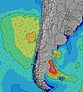 | 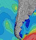 | 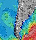 | 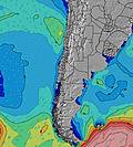 | |||||||||||||
Wave Height (m) Direction Period (s) | SW 14 | SW 14 | SW 14 | SW 13 | SW 13 | SW 13 | SSW 15 | SSW 14 | SSW 13 | SSW 13 | SSW 13 | SW 13 | SSW 13 | W 17 | W 15 | W 14 | W 13 | W 12 | W 11 | W 10 | SW 12 |
Wave Graph | |||||||||||||||||||||
1733 | 2633 | 1979 | 1288 | 816 | 1144 | 1488 | 1553 | 1216 | 890 | 946 | 854 | 572 | 1815 | 5664 | 6560 | 3606 | 2202 | 1096 | 546 | 614 | |
Wind (km/h) | |||||||||||||||||||||
Wind State on-shore cross-onshore cross-shore cross-offshore off-shore glassy | glassy | off | glassy | cross-on | on | on | off | off | cross-off | off | glassy | cross-off | glassy | cross-on | on | on | on | on | cross-on | cross-off | on |
High Tide | 5:49AM1.14m | 5:58PM0.88m | 6:54AM1.25m | 7:23PM0.85m | 7:57AM1.39m | 8:37PM0.86m | 8:55AM1.52m | 9:38PM0.90m | 9:49AM1.63m | 10:32PM0.94m | 10:40AM1.71m | 11:20PM0.98m | 11:29AM1.72m | ||||||||
Low Tide | 11:04PM0.31m | 12:28PM0.43m | 00:03AM0.32m | 1:48PM0.33m | 1:06AM0.31m | 2:55PM0.21m | 2:06AM0.26m | 3:52PM0.09m | 3:03AM0.20m | 4:43PM0.00m | 3:56AM0.13m | 5:31PM-0.05m | 4:47AM0.09m | 6:17PM-0.07m | |||||||
— | 8:07 | — | — | 8:07 | — | — | 8:07 | — | — | 8:07 | — | — | 8:07 | — | — | 8:06 | — | — | 8:06 | — | |
5:50 | — | 5:51 | — | — | 5:51 | — | — | 5:52 | — | — | 5:52 | — | — | 5:52 | — | — | 5:53 | — | — | 5:54 | |
mm | — | — | — | 21 | 3 | — | — | — | — | — | — | — | — | — | 3 | 8 | 2 | 2 | 1 | 15 | 18 |
Temp °C | 11 | 10 | 13 | 13 | 14 | 13 | 12 | 9 | 11 | 9 | 11 | 12 | 11 | 13 | 13 | 13 | 13 | 13 | 12 | 11 | 13 |
Feels °C | 10 | 8 | 12 | 8 | 10 | 9 | 10 | 5 | 7 | 5 | 9 | 10 | 9 | 8 | 7 | 9 | 10 | 10 | 9 | 10 | 7 |
Swell 1 Height (m) Direction Period (s) | W 11 | SW 14 | SW 14 | SW 13 | SW 13 | WNW 9 | WNW 10 | SSW 14 | SSW 13 | SSW 13 | SSW 13 | SW 13 | SSW 13 | W 17 | W 15 | W 14 | W 13 | W 12 | W 11 | W 10 | SW 12 |
1509 | 2633 | 1979 | 1288 | 816 | 737 | 712 | 1553 | 1216 | 890 | 946 | 854 | 572 | 1815 | 5664 | 6560 | 3606 | 2202 | 1096 | 546 | 614 | |
Swell 2 Height (m) Direction Period (s) | SW 14 | WNW 11 | W 11 | W 11 | W 11 | SW 13 | SSW 15 | WNW 10 | WNW 10 | WNW 9 | W 9 | W 9 | W 8 | SW 13 | SW 13 | SSW 13 | SW 12 | SW 12 | SW 12 | SW 12 | W 10 |
1733 | 737 | 565 | 291 | 188 | 1144 | 1488 | 322 | 235 | 141 | 101 | 78 | 36 | 400 | 347 | 215 | 223 | 112 | 286 | 502 | 356 | |
Swell 3 Height (m) Direction Period (s) | SW 10 | — | — | — | — | SSW 16 | SW 8 | SSW 6 | — | W 16 | — | — | W 16 | WNW 8 | — | — | — | WSW 13 | WNW 14 | NW 14 | SW 17 |
600 | — | — | — | — | 552 | 114 | 24 | — | 5 | — | — | 5 | 144 | — | — | — | 63 | 20 | 8 | 104 | |
Wind waves Height (m) Direction Period (s) | — | — | — | NNE 4 | NW 7 | — | — | — | — | SSW 4 | — | — | — | N 3 | — | — | — | — | — | — | — |
— | — | — | 17 | 423 | — | — | — | — | 16 | — | — | — | 8 | — | — | — | — | — | — | — | |
Nearest Offshore or Glassy | |||||||||||||||||||||
Distance (km) | 0 | 0 | 0 | 376 | 376 | 376 | 0 | 0 | 45 | 0 | 0 | 0 | 0 | 206 | 376 | 376 | 376 | 376 | 145 | 0 | 380 |
Best forecast wave conditions in Concepcion | |||||||||||||||||||||
Best forecast wave conditions in Chile | |||||||||||||||||||||
Header Global | |||||||||||||||||||||
- Map Icons:
 Break
Break Live Wave Height (m)
 Live Wind Speed (km/h)
 Surf Rating (10 Max)
 Ocean Swells (m)
- Wind Speed (km/h)


FREE! Surf-Forecast.com widget for your website
The surf report / weather widget below is available to embed on third party websites free of charge and provides a summary of our Lebu surf forecast. Simply grab the html code snippet that we provide and paste it into your own site. You can choose your preferred language and metric/imperial units for the surf forecast feed to suit users of your site. Click here to get the code.
Information about the Lebu Surf forecast
The above surf forecast table for Lebu provides essential information for determining whether the surfing conditions will be good over the next 16 days. A general guide to surfing at Lebu can be found by selecting the local surf guide option on the grey menu. Our Lebu surf forecast is unique since it includes wave energy (power) that defines the real feel of the surf rather than just the height or the period. If you surf the same spot (Lebu) regularly then make a mental note of the wave energy from the surf forecast table each time you go. Very soon you may start to choose your surf days based on the wave energy alone combined with our forecast of favourable offshore wind conditions. Our star ratings will help here and of course you will also find the usual wave height and period predictions on our surf forecasts as well as a full break down of the swell components under our advanced users option (to reveal that, click the little Einstein character under the tide times).
Further information to help with frequently asked questions about our surf forecast for Lebu may be found under the help tab on the top menu and also by moving your mouse over the question marks on the surf forecast table itself. Please always bear in mind that the forecast is for near-shore open water and local factors at each surf break influence the actual breaking wave height, such as the beach / reef profile, water depths offshore and shelter.
Lebu is 2 km (1 miles) from Lebu. If you plan a holiday in Concepcion, look for hotels and other accommodation in Lebu. Lebu has rooms for a wide range of budgets as well as car hire and transport links.
 Nearest