

Surf Forecasts:

Cahuil surf forecast from 14 Jul 2026:
- Best quality surf: Tuesday 14 Jul, 2AM (local time) - 11ft (3.5m), 14s period, WSW swell with glassy winds.
- Most powerful swell: Tuesday 14 Jul, 2AM (local time) - 11ft (3.5m), 14s period, WSW swell with 5,192 kJ wave energy.
- Next surfable swell (1★+): Tuesday 14 Jul, 2AM (local time) - 11ft (3.5m), 14s period with WSW swell.
Best Forecast Surf Conditions for Cahuil this week:
The surf forecast for Cahuil over the next 16 days: The first swell (rated 1 star or higher) is forecast to arrive on Tuesday (Jul 14) at 2AM. The primary swell is predicted to be 3.5m and 14s period. The wind is predicted to be glassy as the swell arrives.
The most powerful waves expected at Cahuil in the next 16 days are 3.5m 14s and forecast to arrive on Tuesday (Jul 14) at 2AM. Winds are predicted to be glassy at the time the swell arrives. The largest open ocean swell (not directed at the beach) is 6.0m 10s period and expected on Thursday (Jul 16) at 11PM.
| Wave Type | Time (-04) & Date | Wave Height & Period |
|---|---|---|
| Next good surf (1 star+) | 2AM (Tue 14th Jul) | 11ft (3.5m) 14s |
| Best Surf | 2AM (Tue 14th Jul) | 11ft (3.5m) 14s |
| Most Powerful | 2AM (Tue 14th Jul) | 11ft (3.5m) 14s |
Table - best surf conditions forecast for Cahuil over the next 16 days.
The Lowdown
Alright folks, Rusty here. Let’s have a look at what’s on the cards for Cahuil over the next couple of weeks.
Right off the bat, we’ve got some solid swell, but for the first few days the wind is going to be a bit of a pain, making things messy. Cahuil is a river break that *rarely breaks*, so when it does, you want the stars to align. This week is a bit of a slow burn.
Tuesday morning kicks off with a 10ft WSW swell at a long 13 seconds, packing a punch with strong wave energy (3468), but that northerly cross-off wind is not doing it any favours. It's surfable but feels marginal. The afternoon drops to 8ft and the wind picks up – not a great time to be out there.
Wednesday afternoon is the first little window that gets interesting for a surfer. A 5ft NW swell with offshore wind from the NE at 9 mph. The clean conditions make this one of the better windows in the first week, even if the swell’s not huge. It’s a modest wave, but for an intermediate surfer, it’s a decent chance for a session.
Saturday afternoon shows up with a 5ft W swell, a 12-second period, and moderate energy (1061). The wind is light from the north, and while the report says it’s excellent for experienced surfers, the cleanup might be okay for the bold intermediate if you pick your tides right. It’s a standout in an otherwise average week.
Now, hold onto your board, because Monday the 20th morning brings a monster. A 13ft WSW swell with short 10-second period and a massive combined energy of 3187 – that is strong wave energy. The wind is light offshore from the ENE. However, the call is that the swell is predicted to be too big for Cahuil. This is expert-only territory, and honestly, with that much water moving, it’s likely a washout or just plain dangerous. The afternoon drops to 8ft, which is more manageable but still heavy.
The second week gets dicey. The 26th and 27th see more 10ft to 15ft WSW swells with long periods up to 15 seconds. The energy readings are off the charts – 7873, 7339, 8228 – that’s very strong wave energy. The forecast keeps saying the swell is too big for this break. For the 28th and 29th, we’re looking at 15ft and 12ft swells with similar massive energy, all too big for the break. If you’re an expert with a death wish and a boat, you might look at it, but for anyone else, the water temperature is about average for the time of year, so you won’t freeze while you’re getting pounded.
Given the size and the fact it’s a river break, on the 26th and 27th with the strong cross-off winds, this setup actually looks more interesting for kite surfing than paddle surfing.
So, to sum it up: the best bet for a decent paddle is Wednesday afternoon, July 15 for a clean, smaller session, or Saturday afternoon, July 18 if you want a bit more power. Everything else is either too windy, too big, or just plain messy. Stay safe out there.
Rusty.
Short Range ForecastHeavy rain (total 24mm), heaviest during Thu afternoon. Very mild (max 15°C on Tue afternoon, min 12°C on Tue morning). Winds increasing (calm on Mon night, near gales from the NNE by Thu afternoon). | Days 5-7 Weather SummaryHeavy rain (total 134mm), heaviest during Sun afternoon. Very mild (max 14°C on Fri morning, min 11°C on Fri night). Winds decreasing (near gales from the NNE on Thu night, light winds from the E by Sat night). | ||||||||||||||||||||
Tuesday 14 | Wednesday 15 | Thursday 16 | Friday 17 | Saturday 18 | Sunday 19 | Mon 20 | |||||||||||||||
Night | AM | PM | Night | AM | PM | Night | AM | PM | Night | AM | PM | Night | AM | PM | Night | AM | PM | Night | AM | PM | |
Swell Height Map |  |  |  |  | 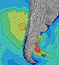 | 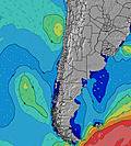 | 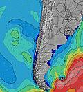 | 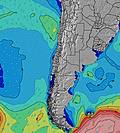 | |||||||||||||
Wave Height (m) Direction Period (s) | WSW 14 | WSW 13 | WSW 13 | W 12 | WNW 9 | NW 8 | WNW 9 | SW 12 | SW 16 | SW 15 | WNW 10 | WNW 10 | SW 12 | SW 12 | W 12 | W 12 | WNW 12 | W 11 | W 11 | WSW 10 | WSW 9 |
Wave Graph | |||||||||||||||||||||
5192 | 3468 | 2172 | 1365 | 463 | 267 | 300 | 110 | 129 | 309 | 661 | 419 | 546 | 361 | 672 | 456 | 374 | 410 | 237 | 3016 | 944 | |
Wind (km/h) | |||||||||||||||||||||
Wind State on-shore cross-onshore cross-shore cross-offshore off-shore glassy | glassy | cross-off | cross-off | cross-off | cross-off | off | cross-off | cross-off | cross-off | cross-off | cross-off | cross-off | cross-off | cross-off | cross-off | cross-off | cross-off | cross-off | on | off | cross-off |
High Tide | 10:01PM0.93m | 10:12AM1.66m | 10:51PM0.98m | 11:02AM1.68m | 11:39PM1.01m | 11:49AM1.65m | 00:26AM1.04m | 12:34PM1.56m | 1:13AM1.06m | 1:19PM1.43m | 2:02AM1.08m | 2:04PM1.27m | 2:53AM1.08m | 2:51PM1.10m | |||||||
Low Tide | 3:30AM0.13m | 5:02PM-0.04m | 4:22AM0.08m | 5:48PM-0.06m | 5:12AM0.07m | 6:32PM-0.05m | 6:03AM0.10m | 7:15PM-0.01m | 6:54AM0.17m | 7:56PM0.06m | 7:49AM0.26m | 8:37PM0.15m | 8:50AM0.35m | ||||||||
— | 7:52 | — | — | 7:52 | — | — | 7:50 | — | — | 7:50 | — | — | 7:50 | — | — | 7:50 | — | — | 7:48 | — | |
5:54 | — | 5:54 | — | — | 5:55 | — | — | 5:55 | — | — | 5:57 | — | — | 5:58 | — | — | 5:58 | — | — | 5:59 | |
mm | — | — | — | — | 3 | 6 | 1 | — | 14 | 45 | 12 | 5 | 27 | 5 | 2 | 3 | 7 | 28 | 45 | 5 | 2 |
Temp °C | 13 | 14 | 15 | 14 | 14 | 14 | 14 | 15 | 14 | 13 | 14 | 14 | 14 | 13 | 14 | 12 | 11 | 14 | 12 | 12 | 13 |
Feels °C | 12 | 11 | 12 | 12 | 10 | 12 | 13 | 8 | 6 | 2 | 10 | 9 | 8 | 9 | 11 | 10 | 9 | 6 | 9 | 10 | 11 |
Swell 1 Height (m) Direction Period (s) | WSW 14 | WSW 13 | WSW 13 | W 12 | WNW 9 | NW 8 | WNW 9 | SW 12 | SW 16 | SW 15 | N 10 | N 10 | SW 12 | NNW 10 | N 9 | NW 10 | WNW 12 | NNW 7 | W 11 | N 10 | WSW 9 |
5192 | 3468 | 2172 | 1365 | 463 | 267 | 300 | 110 | 129 | 309 | 1243 | 1170 | 546 | 1505 | 661 | 309 | 374 | 176 | 237 | 1147 | 944 | |
Swell 2 Height (m) Direction Period (s) | — | — | — | WNW 14 | SW 11 | W 10 | SW 11 | SW 17 | SW 11 | — | WNW 10 | WNW 10 | WNW 11 | WNW 10 | W 12 | W 12 | SW 11 | W 11 | SW 11 | NW 13 | N 9 |
— | — | — | 21 | 237 | 153 | 142 | 106 | 64 | — | 661 | 419 | 353 | 345 | 672 | 456 | 169 | 410 | 121 | 171 | 380 | |
Swell 3 Height (m) Direction Period (s) | — | — | — | NW 10 | NW 14 | SW 10 | NW 13 | WNW 13 | SW 11 | — | WSW 10 | SW 10 | WSW 13 | SW 12 | SW 12 | SSW 11 | W 11 | SW 11 | — | — | WSW 11 |
— | — | — | 4 | 8 | 98 | 7 | 17 | 33 | — | 196 | 235 | 35 | 361 | 389 | 207 | 119 | 172 | — | — | 198 | |
Wind waves Height (m) Direction Period (s) | — | — | N 4 | NE 4 | N 5 | — | — | NNW 8 | NNW 10 | NNW 10 | — | — | N 9 | — | — | — | N 6 | — | N 8 | WSW 10 | — |
— | — | 14 | 13 | 61 | — | — | 935 | 4230 | 6384 | — | — | 1412 | — | — | — | 213 | — | 1102 | 3016 | — | |
Nearest Offshore or Glassy | |||||||||||||||||||||
Distance (km) | 5 | 111 | 5 | 101 | 59 | 0 | 0 | 216 | 1196 | 216 | 216 | 1190 | 191 | 202 | 0 | 0 | 0 | 170 | 170 | 5 | 0 |
Best forecast wave conditions in Santiago | |||||||||||||||||||||
Best forecast wave conditions in Chile | |||||||||||||||||||||
Header Global | |||||||||||||||||||||
- Map Icons:
 Break
Break Live Wave Height (m)
 Live Wind Speed (km/h)
 Surf Rating (10 Max)
 Ocean Swells (m)
- Wind Speed (km/h)


FREE! Surf-Forecast.com widget for your website
The surf report / weather widget below is available to embed on third party websites free of charge and provides a summary of our Cahuil surf forecast. Simply grab the html code snippet that we provide and paste it into your own site. You can choose your preferred language and metric/imperial units for the surf forecast feed to suit users of your site. Click here to get the code.
Information about the Cahuil Surf forecast
The above surf forecast table for Cahuil provides essential information for determining whether the surfing conditions will be good over the next 16 days. A general guide to surfing at Cahuil can be found by selecting the local surf guide option on the grey menu. Our Cahuil surf forecast is unique since it includes wave energy (power) that defines the real feel of the surf rather than just the height or the period. If you surf the same spot (Cahuil) regularly then make a mental note of the wave energy from the surf forecast table each time you go. Very soon you may start to choose your surf days based on the wave energy alone combined with our forecast of favourable offshore wind conditions. Our star ratings will help here and of course you will also find the usual wave height and period predictions on our surf forecasts as well as a full break down of the swell components under our advanced users option (to reveal that, click the little Einstein character under the tide times).
Further information to help with frequently asked questions about our surf forecast for Cahuil may be found under the help tab on the top menu and also by moving your mouse over the question marks on the surf forecast table itself. Please always bear in mind that the forecast is for near-shore open water and local factors at each surf break influence the actual breaking wave height, such as the beach / reef profile, water depths offshore and shelter.
 Nearest