

Surf Forecasts:

Cartagena surf forecast from 13 Jul 2026:
- Best quality surf: Monday 13 Jul, 8PM (local time) - 8ft (2.5m), 16s period, WSW swell with glassy winds.
- Most powerful swell: Monday 13 Jul, 8PM (local time) - 8ft (2.5m), 16s period, WSW swell with 3,622 kJ wave energy.
- Next surfable swell (1★+): Monday 13 Jul, 8PM (local time) - 8ft (2.5m), 16s period with WSW swell.
Best Forecast Surf Conditions for Cartagena this week:
The surf forecast for Cartagena over the next 16 days: The first swell (rated 1 star or higher) is forecast to arrive on Monday (Jul 13) at 8PM. The primary swell is predicted to be 2.5m and 16s period with a secondary swell of 0.5m and 8s. The wind is predicted to be glassy as the swell arrives.
The most powerful waves expected at Cartagena in the next 16 days are 2.5m 16s and forecast to arrive on Monday (Jul 13) at 8PM. Winds are predicted to be glassy at the time the swell arrives. The largest open ocean swell (not directed at the beach) is 5.0m 10s period and expected on Saturday (Jul 18) at 2AM.
| Wave Type | Time (-04) & Date | Wave Height & Period |
|---|---|---|
| Next good surf (1 star+) | 8PM (Mon 13th Jul) | 8ft (2.5m) 16s |
| Best Surf | 8PM (Mon 13th Jul) | 8ft (2.5m) 16s |
| Most Powerful | 8PM (Mon 13th Jul) | 8ft (2.5m) 16s |
Table - best surf conditions forecast for Cartagena over the next 16 days.
The Lowdown
Alright, folks. Rusty here. Let's take a look at what's cooking for Cartagena. This is a consistent sandbar that's wide open to the swell, with the best waves coming from the SW. Water temp is about 54°, which is a bit cooler than usual for this time of year.
We’ve got a solid run of surf starting Monday the 13th. The standout is that Monday afternoon. It's glassy, with a solid 8ft WSW groundswell. The period is a very long 16 seconds, and the energy is pumping hard at 3269. This is clean, powerful, and lined up. But that size and long period means it's for experienced surfers only. The crowds can be around sometimes, but the quality will be worth it. That's the best session on offer.
Tuesday the 14th keeps the goods coming. Both the morning and afternoon have clean 8ft to 8ft WSW swell, with a period around 13 seconds, and a light cross-off breeze. The energy is still strong (2354 and 1816). Still excellent, just a touch more wind on it than Monday.
Wednesday the 15th sees a drop in size. The morning is a clean 4ft W swell with an 11-second period, and the afternoon goes glassy with a 5ft W swell. Energy drops to moderate (605 and 539). It’s good, clean fun, but the real power is gone.
Then we hit a rough patch. From Thursday the 16th through Sunday the 19th, forget it. Strong winds from the N (22-28 mph) and poor conditions ruin the surf. The swell is there but the wind is howling, and you'll see rain and thunderstorms. This is more of a kite-surfing setup than a paddle session.
Monday the 20th and Tuesday the 21st are marginal. The swell is small (3ft to 3ft W) and the winds are light, but the conditions are ordinary. You might get a few, but it's not worth getting excited about.
Things start to look up on Wednesday the 22nd afternoon. A clean 4ft W swell with a 10-second period and light offshore wind. It's surfable.
The next real standout is Thursday the 23rd morning. The swell jumps back up to 6ft from the WSW at a 12-second period, with a light cross-off breeze. The combined energy is strong at 1298. This is excellent for experienced surfers, and the direction is right on the money.
Friday the 24th is a mixed bag. The morning is clean with a 5ft WSW swell, but the afternoon gets a cross-onshore wind that makes it choppy.
Saturday the 25th and Sunday the 26th are a story of two halves. Saturday is small and ordinary. But Sunday the 26th morning is another cracker. It's glassy, with an 8ft WSW swell and a very long 14-second period. The energy is 2517. This is a serious groundswell, clean and powerful. Again, experts only.
Monday the 27th morning is glassy and clean with a 7ft W swell, 12-second period, and energy of 1243. A solid session.
Finally, Tuesday the 28th is a bit of a wild card. The morning has a 10ft WSW swell, but the wind is a light cross-shore. The afternoon is a 12ft WSW swell, which is just too big for this break. The energy is the highest we've seen at 3501, but it's a pass for paddle surfing.
So, to sum it up: the clear winners are Monday the 13th afternoon and Sunday the 26th morning. Both are glassy, clean, and have powerful, long-period groundswells. If you're an experienced surfer, those are your sessions. The rest of the week is a mix of good, marginal, and blown-out.
Rusty.
Short Range ForecastMostly dry. Very mild (max 18°C on Wed afternoon, min 13°C on Mon night). Winds increasing (calm on Mon night, fresh winds from the N by Thu morning). | Days 5-7 Weather SummaryHeavy rain (total 123mm), heaviest during Fri morning. Very mild (max 16°C on Thu afternoon, min 11°C on Sat night). Winds decreasing (near gales from the N on Thu night, light winds from the ENE by Sat night). | ||||||||||||||||||||
Mon 13 | Tuesday 14 | Wednesday 15 | Thursday 16 | Friday 17 | Saturday 18 | Sunday 19 | |||||||||||||||
PM | Night | AM | PM | Night | AM | PM | Night | AM | PM | Night | AM | PM | Night | AM | PM | Night | AM | PM | Night | AM | |
Swell Height Map |  |  |  | 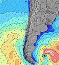 | 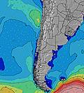 | 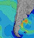 | 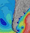 | 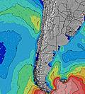 | |||||||||||||
Wave Height (m) Direction Period (s) | WSW 16 | WSW 14 | WSW 13 | WSW 13 | WSW 12 | W 11 | W 10 | WNW 8 | NW 8 | SW 17 | NW 11 | NW 10 | SW 13 | SW 13 | WNW 10 | NW 9 | NW 11 | WNW 11 | W 11 | WNW 11 | WNW 11 |
Wave Graph | |||||||||||||||||||||
3149 | 3566 | 2354 | 1816 | 933 | 388 | 480 | 197 | 403 | 46 | 1652 | 967 | 142 | 136 | 833 | 750 | 408 | 572 | 565 | 608 | 356 | |
Wind (km/h) | |||||||||||||||||||||
Wind State on-shore cross-onshore cross-shore cross-offshore off-shore glassy | glassy | glassy | cross-off | cross-off | cross-off | cross-off | glassy | cross-off | cross-off | cross-off | cross-off | cross-off | cross-off | cross-off | cross-off | cross-off | cross-off | cross-off | cross-off | cross-on | cross |
High Tide | 9:55PM0.92m | 10:06AM1.64m | 10:45PM0.96m | 10:55AM1.66m | 11:33PM1.00m | 11:42AM1.63m | 00:20AM1.03m | 12:28PM1.55m | 1:07AM1.05m | 1:13PM1.42m | 1:56AM1.07m | 1:58PM1.26m | 2:47AM1.07m | ||||||||
Low Tide | 4:07PM0.02m | 3:23AM0.12m | 4:56PM-0.04m | 4:15AM0.08m | 5:42PM-0.07m | 5:06AM0.07m | 6:26PM-0.06m | 5:56AM0.10m | 7:08PM-0.01m | 6:48AM0.16m | 7:50PM0.05m | 7:43AM0.25m | 8:31PM0.14m | 8:43AM0.34m | |||||||
— | — | 7:48 | — | — | 7:48 | — | — | 7:48 | — | — | 7:47 | — | — | 7:47 | — | — | 7:46 | — | — | 7:46 | |
5:54 | — | — | 5:55 | — | — | 5:55 | — | — | 5:57 | — | — | 5:57 | — | — | 5:58 | — | — | 5:59 | — | 5:59 | |
mm | — | — | — | — | — | — | — | — | — | 9 | 22 | 33 | 5 | 35 | 1 | 1 | 11 | 6 | 10 | 30 | 2 |
Temp °C | 17 | 14 | 15 | 15 | 14 | 16 | 18 | 14 | 18 | 16 | 13 | 14 | 14 | 14 | 14 | 15 | 13 | 15 | 16 | 12 | 12 |
Feels °C | 14 | 14 | 13 | 13 | 12 | 13 | 13 | 13 | 11 | 8 | 3 | 6 | 8 | 6 | 10 | 11 | 12 | 11 | 12 | 6 | 10 |
Swell 1 Height (m) Direction Period (s) | WSW 16 | WSW 14 | WSW 13 | WSW 13 | WSW 12 | W 11 | W 10 | WNW 8 | SW 12 | SW 12 | NW 11 | NW 10 | SW 13 | SW 13 | WNW 10 | NW 9 | NW 11 | WNW 11 | W 11 | WNW 11 | WNW 11 |
3149 | 3566 | 2354 | 1816 | 933 | 388 | 480 | 197 | 47 | 35 | 1652 | 967 | 142 | 136 | 833 | 750 | 408 | 572 | 565 | 608 | 356 | |
Swell 2 Height (m) Direction Period (s) | SW 13 | — | — | — | WNW 14 | SW 11 | SW 12 | SW 10 | SW 18 | SW 17 | SW 16 | SW 9 | WSW 9 | WSW 15 | N 9 | W 12 | W 12 | SW 11 | SW 11 | SW 11 | WSW 6 |
85 | — | — | — | 20 | 209 | 52 | 84 | 49 | 46 | 151 | 90 | 53 | 21 | 380 | 110 | 403 | 58 | 60 | 58 | 14 | |
Swell 3 Height (m) Direction Period (s) | W 8 | — | — | — | NW 10 | NW 14 | NW 14 | W 10 | WNW 13 | — | — | SW 14 | WSW 15 | — | SW 12 | SW 12 | N 7 | — | — | — | SW 11 |
35 | — | — | — | 4 | 8 | 7 | 8 | 17 | — | — | 123 | 21 | — | 122 | 114 | 37 | — | — | — | 57 | |
Wind waves Height (m) Direction Period (s) | — | — | — | — | — | NNE 3 | — | — | NW 8 | NNW 9 | NNW 10 | NNW 9 | NNW 10 | NNW 10 | — | — | — | — | — | — | — |
— | — | — | — | — | 3 | — | — | 403 | 2989 | 1525 | 773 | 2154 | 5084 | — | — | — | — | — | — | — | |
Nearest Offshore or Glassy | |||||||||||||||||||||
Distance (km) | 0 | 0 | 0 | 0 | 0 | 0 | 0 | 0 | 387 | 106 | 106 | 387 | 343 | 302 | 387 | 68 | 10 | 107 | 302 | 84 | 31 |
Best forecast wave conditions in Santiago | |||||||||||||||||||||
Best forecast wave conditions in Chile | |||||||||||||||||||||
Header Global | |||||||||||||||||||||
- Map Icons:
 Break
Break Live Wave Height (m)
 Live Wind Speed (km/h)
 Surf Rating (10 Max)
 Ocean Swells (m)
- Wind Speed (km/h)


FREE! Surf-Forecast.com widget for your website
The surf report / weather widget below is available to embed on third party websites free of charge and provides a summary of our Cartagena surf forecast. Simply grab the html code snippet that we provide and paste it into your own site. You can choose your preferred language and metric/imperial units for the surf forecast feed to suit users of your site. Click here to get the code.
Information about the Cartagena Surf forecast
The above surf forecast table for Cartagena provides essential information for determining whether the surfing conditions will be good over the next 16 days. A general guide to surfing at Cartagena can be found by selecting the local surf guide option on the grey menu. Our Cartagena surf forecast is unique since it includes wave energy (power) that defines the real feel of the surf rather than just the height or the period. If you surf the same spot (Cartagena) regularly then make a mental note of the wave energy from the surf forecast table each time you go. Very soon you may start to choose your surf days based on the wave energy alone combined with our forecast of favourable offshore wind conditions. Our star ratings will help here and of course you will also find the usual wave height and period predictions on our surf forecasts as well as a full break down of the swell components under our advanced users option (to reveal that, click the little Einstein character under the tide times).
Further information to help with frequently asked questions about our surf forecast for Cartagena may be found under the help tab on the top menu and also by moving your mouse over the question marks on the surf forecast table itself. Please always bear in mind that the forecast is for near-shore open water and local factors at each surf break influence the actual breaking wave height, such as the beach / reef profile, water depths offshore and shelter.
Cartagena is 12 km (7 miles) from the city of San Antonio. If you plan a holiday in Santiago, look for hotels and other accommodation in San Antonio. San Antonio has rooms for a wide range of budgets as well as car hire and transport links.
 Nearest