

Surf Forecasts:

Balnarring Point surf forecast from 3 Aug 2026:
- Best quality surf: Monday 10 Aug, 4PM (local time) - 11ft (3.5m), 16s period, SW swell with glassy winds.
- Most powerful swell: Monday 10 Aug, 10PM (local time) - 11ft (3.5m), 17s period, SW swell with 7,672 kJ wave energy.
- Next surfable swell (1★+): Thursday 6 Aug, 1AM (local time) - 3ft (0.9m), 13s period with SW swell.
Best Forecast Surf Conditions for Balnarring Point this week:
The surf forecast for Balnarring Point over the next 16 days: The first swell (rated 1 star or higher) is forecast to arrive on Thursday (Aug 06) at 1AM. The primary swell is predicted to be 0.9m and 13s period with a secondary swell of 1.0m and 6s. The wind is predicted to be offshore as the swell arrives.
The most powerful waves expected at Balnarring Point in the next 16 days are 3.5m 17s and forecast to arrive on Monday (Aug 10) at 10PM. Winds are predicted to be cross-offshore at the time the swell arrives. The largest open ocean swell (not directed at the beach) is 1.7m 5s period and expected on Sunday (Aug 09) at 10AM.
| Wave Type | Time (AEST) & Date | Wave Height & Period |
|---|---|---|
| Next good surf (1 star+) | 1AM (Thu 6th Aug) | 3ft (0.9m) 13s |
| Best Surf | 4PM (Mon 10th Aug) | 11ft (3.5m) 16s |
| Most Powerful | 10PM (Mon 10th Aug) | 11ft (3.5m) 17s |
Table - best surf conditions forecast for Balnarring Point over the next 16 days.
The Lowdown
Alright folks, Rusty here. Let’s have a look at what’s on the cards for Balnarring Point.
We’ve got a bit of a slow start, then a run of building energy that gets seriously big towards the end of the first week and into the second. The standout window is clear, but you’ll need to pick your moments with the wind. The water temperature is sitting about average for this time of year at 55°F.
The first few days are a bit of a write-off, honestly. Monday afternoon the 3rd kicks off with some 6ft swell from the WSW, but the energy is only moderate (1553) and that cross-off breeze is fresh, making it hard work. Not the one. Tuesday the 4th is grumpy with rain and a fresh offshore, but the swell is a bit messed up, and the energy is still only moderate. Wednesday the 5th is small and messy.
Things start to look up on Thursday the 6th. A light offshore and a clean 2ft SW groundswell, with 16-second period, but the energy is weak (400). It’s a starter wave, nice and clean for a beginner. By Friday the 7th, we’re onto something. That is the best day of the first week. The morning is clean with a light offshore breeze, 5ft of SW groundswell with a very long 16-second period, and the energy is pumping into the strong range (1250). By afternoon, it goes glassy. The waves will be lined up, but with that long period and a point break setup, it’ll reel off nicely. Keep in mind, it’s inconsistent here, so you’ll be waiting for the sets, but they’ll be worth it. Crowds are often here, so get in early.
Saturday the 8th is still rideable with 5ft to 6ft swell, but the wind picks up and it’s more cross-off, so not as clean. Sunday the 9th is a full write-off with near gale force winds – don’t bother.
Now, the second week brings the muscle. Monday the 10th is a monster. We’re looking at 12ft of SW swell, with a very long 17-second period. The energy is massive (7126). The morning is okay, but the afternoon is glassy. This is a serious, powerful swell. This is only for experienced surfers, and the point should handle it when it’s glassy, but it’s going to be a beast. This is a standout for the big-wave crew.
Tuesday the 11th is still pumping, 10ft dropping to 8ft, but the wind is a fresh cross-off, so it’s less appealing. Wednesday the 12th is too big and windy – 13ft and a strong breeze, just a washing machine. Thursday the 13th is a no-go, with strong cross-shore winds making it ugly. Friday the 14th is another big day, 13ft to 16ft of SW swell but again, cross-off winds. The energy is extreme (10702 on the afternoon), but it’s not clean. The weekend of the 15th and 16th is still huge, 13ft to 15ft, but cross-shore chop ruins it.
The very last day, Monday the 17th, is interesting. 13ft of SW swell, but with a shorter 10-second period, and a moderate offshore wind. The energy is strong (2792). The shorter period might make the huge swell a bit more manageable at the point, and it’s excellent for experienced surfers. That’s your second standout, but it’s a long way off.
So, the pick of the lot is Friday the 7th for the everyday surfer, and Monday the 10th afternoon for the big-wave chargers. The rest is either too small, too windy, or too big and messy.
Rusty.
Short Range ForecastModerate rain (total 19mm), heaviest on Mon night. Very mild (max 13°C on Mon afternoon, min 8°C on Mon night). Mainly fresh winds. | Days 5-7 Weather SummaryLight rain (total 7mm), mostly falling on Sun morning. Very mild (max 14°C on Sat morning, min 9°C on Fri morning). Winds increasing (calm on Fri afternoon, strong winds from the N by Sat night). | |||||||||||||||||||
Mon 3 | Tuesday 4 | Wednesday 5 | Thursday 6 | Friday 7 | Saturday 8 | Sunday 9 | ||||||||||||||
PM | Night | AM | PM | Night | AM | PM | Night | AM | PM | Night | AM | PM | Night | AM | PM | Night | AM | PM | Night | |
Swell Height Map |  |  |  | 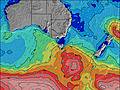 | 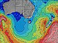 | 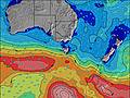 | 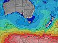 | |||||||||||||
Wave Height (m) Direction Period (s) | WSW 15 | WSW 13 | WSW 11 | SW 11 | SW 10 | SW 20 | SW 14 | SW 13 | SW 12 | SW 16 | SW 18 | SW 16 | SW 15 | SW 14 | SW 16 | SW 16 | SW 15 | SW 15 | SW 14 | SW 19 |
Wave Graph | ||||||||||||||||||||
1546 | 1349 | 634 | 1256 | 622 | 239 | 1255 | 282 | 206 | 406 | 528 | 1074 | 966 | 742 | 1384 | 1438 | 940 | 784 | 799 | 1445 | |
Wind (km/h) | ||||||||||||||||||||
Wind State on-shore cross-onshore cross-shore cross-offshore off-shore glassy | cross-off | cross-off | off | cross-off | cross-off | cross-off | cross-off | off | off | off | cross-off | off | glassy | cross | cross-off | cross-off | cross-off | cross-off | cross-off | cross-off |
High Tide | 4:14AM2.67m | 4:30PM2.84m | 4:56AM2.75m | 5:01PM2.83m | 5:39AM2.81m | 5:34PM2.81m | 6:24AM2.82m | 6:09PM2.79m | 7:12AM2.80m | 6:51PM2.74m | 8:06AM2.75m | 7:39PM2.66m | ||||||||
Low Tide | 10:07PM0.74m | 10:14AM0.71m | 10:41PM0.62m | 10:53AM0.80m | 11:16PM0.51m | 11:31AM0.91m | 11:53PM0.42m | 12:12PM1.04m | 00:35AM0.37m | 12:57PM1.17m | 1:22AM0.37m | 1:50PM1.30m | 2:18AM0.42m | |||||||
— | — | 7:18 | — | — | 7:16 | — | — | 7:16 | — | — | 7:15 | — | — | 7:13 | — | — | 7:13 | — | — | |
5:31 | — | — | 5:31 | — | — | 5:32 | — | — | 5:34 | — | — | 5:35 | — | — | 5:36 | — | — | 5:37 | — | |
mm | — | 4 | 2 | 3 | 7 | 2 | 1 | — | — | 1 | 1 | — | — | — | — | — | 2 | 3 | 1 | 3 |
Temp °C | 13 | 10 | 11 | 12 | 11 | 12 | 12 | 11 | 9 | 12 | 12 | 10 | 12 | 11 | 14 | 14 | 13 | 11 | 10 | 11 |
Feels °C | 6 | 4 | 4 | 6 | 7 | 7 | 6 | 6 | 3 | 7 | 6 | 8 | 10 | 7 | 8 | 8 | 5 | 1 | 0 | 2 |
Swell 1 Height (m) Direction Period (s) | WSW 15 | WSW 13 | WSW 11 | SW 11 | SW 10 | SW 13 | SW 19 | SW 6 | SW 12 | SW 16 | SW 18 | SW 16 | SW 15 | SW 14 | SW 16 | SW 16 | SW 15 | SW 15 | SW 14 | SW 12 |
1546 | 1349 | 634 | 1256 | 622 | 103 | 284 | 72 | 175 | 406 | 528 | 1074 | 966 | 742 | 1384 | 1438 | 940 | 784 | 799 | 1305 | |
Swell 2 Height (m) Direction Period (s) | S 20 | SW 17 | SW 13 | S 16 | SW 21 | SW 20 | SSW 15 | SW 13 | WSW 5 | SW 5 | SW 14 | SW 6 | SW 19 | SW 18 | SSW 17 | SSW 16 | WSW 18 | — | — | SW 19 |
7 | 241 | 431 | 5 | 154 | 239 | 21 | 282 | 19 | 10 | 211 | 60 | 441 | 516 | 57 | 86 | 127 | — | — | 1445 | |
Swell 3 Height (m) Direction Period (s) | — | — | — | — | S 21 | WSW 11 | SSW 19 | SW 18 | SW 16 | S 5 | WSW 10 | SSW 16 | SSW 6 | S 6 | SSW 6 | — | SSW 15 | — | — | SSW 19 |
— | — | — | — | 9 | 12 | 34 | 197 | 206 | 2 | 86 | 52 | 33 | 19 | 4 | — | 42 | — | — | 72 | |
Wind waves Height (m) Direction Period (s) | NW 4 | SW 14 | WNW 4 | SW 12 | — | SW 6 | SW 14 | — | NW 3 | WNW 3 | SW 7 | WSW 7 | — | — | N 3 | N 3 | NNW 5 | WNW 5 | WSW 7 | NW 5 |
13 | 1058 | 32 | 946 | — | 233 | 1255 | — | 2 | 8 | 178 | 64 | — | — | 7 | 8 | 66 | 147 | 621 | 76 | |
Nearest Offshore or Glassy | ||||||||||||||||||||
Distance (km) | 100 | 65 | 98 | 81 | 12 | 69 | 69 | 0 | 0 | 27 | 12 | 0 | 0 | 17 | 17 | 29 | 101 | 542 | 542 | 456 |
Best forecast wave conditions in Mornington Peninsula | ||||||||||||||||||||
Best forecast wave conditions in Australia | ||||||||||||||||||||
Header Global | ||||||||||||||||||||
- Map Icons:
 Break
Break Live Wave Height (m)
 Live Wind Speed (km/h)
 Surf Rating (10 Max)
 Ocean Swells (m)
- Wind Speed (km/h)
Latest Updates


FREE! Surf-Forecast.com widget for your website
The surf report / weather widget below is available to embed on third party websites free of charge and provides a summary of our Balnarring Point surf forecast. Simply grab the html code snippet that we provide and paste it into your own site. You can choose your preferred language and metric/imperial units for the surf forecast feed to suit users of your site. Click here to get the code.
Information about the Balnarring Point Surf forecast
The above surf forecast table for Balnarring Point provides essential information for determining whether the surfing conditions will be good over the next 16 days. A general guide to surfing at Balnarring Point can be found by selecting the local surf guide option on the grey menu. Our Balnarring Point surf forecast is unique since it includes wave energy (power) that defines the real feel of the surf rather than just the height or the period. If you surf the same spot (Balnarring Point) regularly then make a mental note of the wave energy from the surf forecast table each time you go. Very soon you may start to choose your surf days based on the wave energy alone combined with our forecast of favourable offshore wind conditions. Our star ratings will help here and of course you will also find the usual wave height and period predictions on our surf forecasts as well as a full break down of the swell components under our advanced users option (to reveal that, click the little Einstein character under the tide times).
Further information to help with frequently asked questions about our surf forecast for Balnarring Point may be found under the help tab on the top menu and also by moving your mouse over the question marks on the surf forecast table itself. Please always bear in mind that the forecast is for near-shore open water and local factors at each surf break influence the actual breaking wave height, such as the beach / reef profile, water depths offshore and shelter.
Balnarring Point is 22 km (14 miles) from Mornington. If you plan a holiday in Mornington Peninsula, look for hotels and other accommodation in Mornington. Mornington has rooms for a wide range of budgets as well as car hire and transport links.
 Nearest