

Surf Forecasts:

Huascar surf forecast from 3 Aug 2026:
- Best quality surf: Tuesday 4 Aug, 5AM (local time) - 5ft (1.6m), 12s period, SW swell with glassy winds.
- Most powerful swell: Thursday 6 Aug, 11AM (local time) - 5ft (1.6m), 16s period, SW swell with 1,194 kJ wave energy.
- Next surfable swell (1★+): Monday 3 Aug, 5AM (local time) - 2.5ft (0.7m), 13s period with SW swell.
Best Forecast Surf Conditions for Huascar this week:
The surf forecast for Huascar over the next 16 days: The first swell (rated 1 star or higher) is forecast to arrive on Monday (Aug 03) at 5AM. The primary swell is predicted to be 0.7m and 13s period with a secondary swell of 0.9m and 7s. The wind is predicted to be cross-offshore as the swell arrives.
The most powerful waves expected at Huascar in the next 16 days are 1.6m 16s and forecast to arrive on Thursday (Aug 06) at 11AM. Winds are predicted to be cross-shore at the time the swell arrives. The largest open ocean swell (not directed at the beach) is 0.3m 11s period and expected on Monday (Aug 03) at 5PM.
| Wave Type | Time (-04) & Date | Wave Height & Period |
|---|---|---|
| Next good surf (1 star+) | 5AM (Mon 3rd Aug) | 2.5ft (0.7m) 13s |
| Best Surf | 5AM (Tue 4th Aug) | 5ft (1.6m) 12s |
| Most Powerful | 11AM (Thu 6th Aug) | 5ft (1.6m) 16s |
Table - best surf conditions forecast for Huascar over the next 16 days.
The Lowdown
Alright folks, Rusty here. Let’s get into it.
Looks like the next couple of weeks at Huascar are a mixed bag, with a few clean windows if you’re patient. The overall pattern is a persistent SW swell, but the wind is the real story – it’s gonna be a battle to find those glassy moments.
The first real standout comes on Tuesday afternoon, August 4th. We’ve got a 5ft SW swell rolling in with a 12-second period, but the magic is that the wind goes completely glassy. That’s a rare treat, and it’ll make the point break at Huascar look absolutely perfect. The combined energy is a solid 769 (moderate), so there’s enough push for a good session. This is your best bet early on, and for advanced surfers, this is a winner.
The next good window is Wednesday afternoon, August 5th. The swell drops a touch to 5ft from the SW, but again we get that glassy wind. The energy is a bit lower at 633, but clean conditions on a point break like this will still dish out some fun waves. The SW swell lines up perfectly with the optimum direction for this spot.
Now, the second week... it gets tougher. The wind turns onshore and cross-shore for most of it, with a lot of lumpy, choppy conditions. The swell stays on the smaller side, around 2ft to 4ft. There’s a glimmer of hope on Friday afternoon, August 14th. The wind drops to dead calm, glassy again, with a 3ft SW groundswell at a very long 15-second period. The combined energy is 410 (weak), so it’ll be small, but on a point break, those long-period lines will wrap in cleanly. It’s a promising but less certain little session for the patient surfer.
The water temperature is about average for this time of year, nothing too unusual.
For the rest of the period, especially from the 7th through the 13th, the wind is howling out of the SW and SSW at 15-25 mph. That’s creating a nasty cross-chop. The swell gets bigger, hitting 8ft on the 10th, but with that wind, it’s a washing machine. On those days, with the poor quality and strong wind over a beach-and-reef setup, this looks more interesting for a kite surfer than a paddle surfer.
So, to sum it up: Tuesday afternoon the 4th and Wednesday afternoon the 5th are your best shots. Then, a small, clean window on the 14th if you’re hanging around. The rest is a battle with the wind.
Rusty.
Short Range ForecastMostly dry. Very mild (max 18°C on Mon morning, min 16°C on Sun night). Wind will be generally light. | Days 5-7 Weather SummaryMostly dry. Very mild (max 17°C on Thu morning, min 14°C on Thu night). Winds increasing (light winds from the SSW on Wed night, fresh winds from the SSW by Sat afternoon). | ||||||||||||||||||
Monday 3 | Tuesday 4 | Wednesday 5 | Thursday 6 | Friday 7 | Saturday 8 | ||||||||||||||
Night | AM | PM | Night | AM | PM | Night | AM | PM | Night | AM | PM | Night | AM | PM | Night | AM | PM | Night | |
Swell Height Map |  |  |  |  | 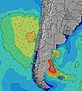 | 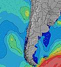 | 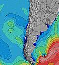 | ||||||||||||
Wave Height (m) Direction Period (s) | SW 7 | SW 12 | SW 12 | SW 12 | SW 12 | SW 12 | SW 12 | SW 12 | SW 12 | SW 12 | SW 16 | SW 14 | SW 14 | SW 13 | SW 13 | SW 9 | SW 10 | SW 10 | SW 9 |
Wave Graph | |||||||||||||||||||
99 | 379 | 785 | 747 | 722 | 747 | 772 | 635 | 514 | 400 | 1194 | 992 | 667 | 444 | 374 | 336 | 479 | 499 | 508 | |
Wind (km/h) | |||||||||||||||||||
Wind State on-shore cross-onshore cross-shore cross-offshore off-shore glassy | cross | cross | cross | cross | cross-on | glassy | glassy | cross-on | glassy | cross | cross | cross | cross | cross | cross | cross | cross | cross | cross |
High Tide | 00:22AM0.84m | 12:16PM1.01m | 1:03AM0.88m | 12:53PM0.91m | 1:50AM0.91m | 1:38PM0.81m | 2:46AM0.94m | 2:38PM0.70m | 3:53AM0.98m | 4:00PM0.63m | 5:06AM1.04m | 5:32PM0.60m | |||||||
Low Tide | 6:03AM0.26m | 6:47PM0.13m | 6:53AM0.30m | 7:19PM0.16m | 7:54AM0.35m | 7:58PM0.20m | 9:13AM0.37m | 8:48PM0.23m | 10:49AM0.35m | 9:53PM0.24m | 12:16PM0.28m | 11:09PM0.23m | |||||||
— | 7:16 | — | — | 7:15 | — | — | 7:13 | — | — | 7:13 | — | — | 7:13 | — | — | 7:13 | — | — | |
6:19 | — | 6:20 | — | — | 6:20 | — | — | 6:21 | — | — | 6:21 | — | — | 6:22 | — | — | 6:22 | — | |
mm | — | — | — | — | — | — | — | — | — | — | — | — | — | — | — | — | — | — | — |
Temp °C | 17 | 18 | 17 | 17 | 17 | 17 | 16 | 17 | 17 | 16 | 17 | 16 | 16 | 17 | 16 | 16 | 16 | 16 | 16 |
Feels °C | 15 | 17 | 16 | 16 | 17 | 17 | 17 | 17 | 17 | 16 | 16 | 16 | 13 | 13 | 12 | 14 | 12 | 12 | 13 |
Swell 1 Height (m) Direction Period (s) | SW 7 | SW 12 | SW 12 | SW 12 | SW 12 | SW 12 | SW 12 | SW 12 | SW 12 | SW 12 | SW 16 | SW 14 | SW 14 | SW 13 | SW 13 | SW 9 | SW 10 | SW 10 | SW 9 |
99 | 379 | 785 | 747 | 722 | 747 | 772 | 635 | 514 | 400 | 1194 | 992 | 667 | 444 | 374 | 336 | 479 | 499 | 508 | |
Swell 2 Height (m) Direction Period (s) | SSW 12 | SW 7 | SSW 11 | NW 13 | NW 12 | SW 21 | SW 20 | SW 19 | SW 18 | SW 17 | NW 12 | NW 11 | SW 7 | SW 7 | W 11 | SW 12 | SW 12 | SW 16 | SW 15 |
94 | 107 | 25 | 6 | 5 | 17 | 62 | 131 | 113 | 334 | 5 | 5 | 45 | 102 | 2 | 187 | 53 | 90 | 171 | |
Swell 3 Height (m) Direction Period (s) | WSW 10 | SSW 11 | NW 12 | — | — | NW 12 | NW 12 | NW 11 | NW 12 | NW 12 | — | — | NW 11 | NW 11 | — | SSW 18 | SW 16 | SW 12 | SW 21 |
51 | 51 | 6 | — | — | 5 | 5 | 5 | 6 | 5 | — | — | 5 | 5 | — | 31 | 67 | 52 | 18 | |
Wind waves Height (m) Direction Period (s) | — | — | — | — | — | — | — | — | — | — | — | — | — | — | SW 7 | — | — | — | — |
— | — | — | — | — | — | — | — | — | — | — | — | — | — | 121 | — | — | — | — | |
Nearest Offshore or Glassy | |||||||||||||||||||
Distance (km) | 97 | 43 | 223 | 22 | 223 | 0 | 0 | 223 | 0 | 43 | 43 | 317 | 97 | 223 | 397 | 317 | 401 | 401 | 317 |
Best forecast wave conditions in Antofagasta | |||||||||||||||||||
Best forecast wave conditions in Chile | |||||||||||||||||||
Header Global | |||||||||||||||||||
- Map Icons:
 Break
Break Live Wave Height (m)
 Live Wind Speed (km/h)
 Surf Rating (10 Max)
 Ocean Swells (m)
- Wind Speed (km/h)
Latest Updates


FREE! Surf-Forecast.com widget for your website
The surf report / weather widget below is available to embed on third party websites free of charge and provides a summary of our Huascar surf forecast. Simply grab the html code snippet that we provide and paste it into your own site. You can choose your preferred language and metric/imperial units for the surf forecast feed to suit users of your site. Click here to get the code.
Information about the Huascar Surf forecast
The above surf forecast table for Huascar provides essential information for determining whether the surfing conditions will be good over the next 16 days. A general guide to surfing at Huascar can be found by selecting the local surf guide option on the grey menu. Our Huascar surf forecast is unique since it includes wave energy (power) that defines the real feel of the surf rather than just the height or the period. If you surf the same spot (Huascar) regularly then make a mental note of the wave energy from the surf forecast table each time you go. Very soon you may start to choose your surf days based on the wave energy alone combined with our forecast of favourable offshore wind conditions. Our star ratings will help here and of course you will also find the usual wave height and period predictions on our surf forecasts as well as a full break down of the swell components under our advanced users option (to reveal that, click the little Einstein character under the tide times).
Further information to help with frequently asked questions about our surf forecast for Huascar may be found under the help tab on the top menu and also by moving your mouse over the question marks on the surf forecast table itself. Please always bear in mind that the forecast is for near-shore open water and local factors at each surf break influence the actual breaking wave height, such as the beach / reef profile, water depths offshore and shelter.
Are you planning a holiday in Antofagasta? If you are looking for accommodation near Huascar, camping, hotels and holiday cottages in Antofagasta, consider staying in Antofagasta which is 20 km (12 miles) away. Alternatively, find information about places to stay and car hire in Mejillones which is 78 km (48 miles) away
 Nearest