

Surf Forecasts:

Pozo Verde surf forecast from 13 Jul 2026:
- Best quality surf: Monday 13 Jul, 8PM (local time) - 3ft (0.9m), 18s period, WSW swell with glassy winds.
- Most powerful swell: Tuesday 14 Jul, 5PM (local time) - 4.5ft (1.4m), 14s period, SW swell with 754 kJ wave energy.
- Next surfable swell (1★+): Monday 13 Jul, 8PM (local time) - 3ft (0.9m), 18s period with WSW swell.
Best Forecast Surf Conditions for Pozo Verde this week:
The surf forecast for Pozo Verde over the next 16 days: The first swell (rated 1 star or higher) is forecast to arrive on Monday (Jul 13) at 8PM. The primary swell is predicted to be 0.9m and 18s period with a secondary swell of 0.7m and 13s. The wind is predicted to be glassy as the swell arrives.
The most powerful waves expected at Pozo Verde in the next 16 days are 1.4m 14s and forecast to arrive on Tuesday (Jul 14) at 5PM. Winds are predicted to be glassy at the time the swell arrives.
| Wave Type | Time (-04) & Date | Wave Height & Period |
|---|---|---|
| Next good surf (1 star+) | 8PM (Mon 13th Jul) | 3ft (0.9m) 18s |
| Best Surf | 8PM (Mon 13th Jul) | 3ft (0.9m) 18s |
| Most Powerful | 5PM (Tue 14th Jul) | 4.5ft (1.4m) 14s |
Table - best surf conditions forecast for Pozo Verde over the next 16 days.
The Lowdown
Alright, let’s talk about Pozo Verde. This point break is consistent and fairly exposed, with the sweet spot coming from SW swell. The water’s sitting at about 62°F, pretty much average for mid-July – nothing weird there.
The 16-day window starts with a bit of a slow warm-up. Monday 13th July is a write-off – tiny 2ft sideshore junk. Then Tuesday 14th July turns on. That’s your standout. Tuesday afternoon shapes up with a clean 5ft SW groundswell rolling in at 14 seconds, glassy as a mirror, and the combined energy sitting at 786 – moderate but punchy. This is the best session on offer: waist-to-chest high lines, offshore wind at 3 mph, and that point will handle the long period beautifully. Crowds are possible at times, but with consistency in the forecast you’ll get your share.
Wednesday 15th July afternoon is also decent – 5ft SW, 13 seconds, glassy again – but the energy drops a notch to 640. Still a good backup if you miss Tuesday. After that, things get patchy. Thursday 16th through Sunday 20th are mostly marginal with onshore or cross-onshore breezes and smaller swell. A few glassy windows pop up – Saturday 18th afternoon shows 3ft WSW at 10 seconds, glassy but weak (337 energy) – worth a paddle if you’re desperate.
The second week gets more interesting around Monday 27th July. That morning shows a 5ft SW groundswell at 14 seconds, energy 898 – the biggest swell of the period. But the wind is cross-onshore from SW at 6 mph, making it a bit bumpy. It’s an expert-only day if you want to chase it; beginners should stay out. Afternoon gets choppier with 9 mph cross-onshore. Tuesday 28th tails off with similar size but messy conditions.
Bottom line: Tuesday 14th July afternoon is your standout – clean, lined-up SW groundswell, glassy, and the point will be singing. Don’t sleep on it.
Rusty
Short Range ForecastMostly dry. Warm (max 22°C on Wed morning, min 15°C on Tue morning). Wind will be generally light. | Days 5-7 Weather SummaryMostly dry. Warm (max 22°C on Fri afternoon, min 19°C on Thu night). Wind will be generally light. | ||||||||||||||||||||
Mon 13 | Tuesday 14 | Wednesday 15 | Thursday 16 | Friday 17 | Saturday 18 | Sunday 19 | |||||||||||||||
PM | Night | AM | PM | Night | AM | PM | Night | AM | PM | Night | AM | PM | Night | AM | PM | Night | AM | PM | Night | AM | |
Swell Height Map |  |  |  | 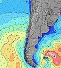 | 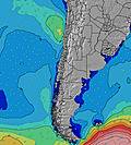 | 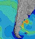 | 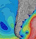 |  | |||||||||||||
Wave Height (m) Direction Period (s) | WSW 20 | WSW 16 | WSW 15 | SW 14 | SW 13 | SW 14 | SW 13 | SW 13 | SW 12 | SW 12 | SW 12 | SW 11 | SW 12 | WSW 10 | WSW 10 | WSW 10 | WSW 12 | WSW 12 | WSW 12 | WSW 11 | WSW 11 |
Wave Graph | |||||||||||||||||||||
336 | 651 | 665 | 754 | 700 | 350 | 623 | 473 | 286 | 200 | 110 | 60 | 309 | 339 | 269 | 209 | 703 | 512 | 438 | 337 | 452 | |
Wind (km/h) | |||||||||||||||||||||
Wind State on-shore cross-onshore cross-shore cross-offshore off-shore glassy | cross-on | glassy | on | glassy | glassy | on | glassy | glassy | on | cross-on | glassy | on | on | glassy | on | glassy | cross | cross-on | cross-on | cross | cross-on |
High Tide | 8:43PM0.68m | 9:05AM1.36m | 9:37PM0.72m | 9:55AM1.39m | 10:28PM0.76m | 10:43AM1.38m | 11:19PM0.80m | 11:30AM1.31m | 00:10AM0.84m | 12:15PM1.21m | 1:02AM0.87m | 1:01PM1.08m | 1:55AM0.89m | 1:48PM0.93m | |||||||
Low Tide | 3:11PM0.05m | 2:15AM0.06m | 4:00PM-0.01m | 3:09AM0.03m | 4:47PM-0.04m | 4:02AM0.03m | 5:32PM-0.05m | 4:55AM0.06m | 6:15PM-0.03m | 5:48AM0.12m | 6:57PM0.01m | 6:45AM0.20m | 7:39PM0.07m | 7:47AM0.28m | |||||||
— | — | 7:20 | — | — | 7:20 | — | — | 7:20 | — | — | 7:20 | — | — | 7:20 | — | — | 7:20 | — | — | 7:20 | |
6:12 | — | — | 6:12 | — | — | 6:13 | — | — | 6:13 | — | — | 6:13 | — | — | 6:14 | — | — | 6:14 | — | 6:15 | |
mm | — | — | — | — | — | — | — | — | — | — | — | — | — | — | — | — | — | — | — | — | — |
Temp °C | 19 | 18 | 19 | 21 | 21 | 22 | 21 | 21 | 21 | 21 | 20 | 21 | 22 | 20 | 22 | 22 | 22 | 21 | 21 | 19 | 22 |
Feels °C | 18 | 18 | 18 | 20 | 21 | 21 | 20 | 21 | 20 | 19 | 19 | 19 | 20 | 18 | 19 | 20 | 19 | 19 | 19 | 19 | 20 |
Swell 1 Height (m) Direction Period (s) | SW 13 | WSW 16 | WSW 15 | SW 14 | SW 13 | SW 14 | SW 13 | SW 13 | SW 12 | SW 12 | SW 12 | SW 11 | SW 12 | WSW 10 | WSW 10 | WSW 10 | WSW 12 | WSW 12 | WSW 12 | WSW 11 | WSW 11 |
178 | 651 | 665 | 754 | 700 | 350 | 623 | 473 | 286 | 200 | 110 | 60 | 309 | 339 | 269 | 209 | 703 | 512 | 438 | 337 | 452 | |
Swell 2 Height (m) Direction Period (s) | WSW 20 | SSW 12 | SSW 13 | WSW 8 | NW 13 | WSW 12 | WNW 13 | WNW 13 | W 10 | W 10 | WSW 9 | WSW 9 | SW 16 | SW 15 | SSW 14 | SSW 13 | NW 11 | SSW 13 | SW 12 | SSW 12 | SSW 11 |
336 | 98 | 120 | 13 | 7 | 269 | 17 | 17 | 8 | 17 | 27 | 26 | 65 | 57 | 78 | 69 | 5 | 67 | 34 | 55 | 47 | |
Swell 3 Height (m) Direction Period (s) | WSW 9 | WSW 9 | SW 9 | WNW 14 | — | WNW 13 | — | — | WNW 13 | NW 12 | WNW 12 | WNW 12 | WNW 12 | WNW 12 | SW 11 | WSW 13 | — | NW 11 | SSW 13 | NW 11 | W 23 |
26 | 31 | 19 | 19 | — | 17 | — | — | 17 | 6 | 14 | 14 | 14 | 14 | 30 | 59 | — | 5 | 17 | 5 | 10 | |
Wind waves Height (m) Direction Period (s) | — | — | — | — | — | — | — | — | — | — | — | — | — | — | — | — | — | — | — | — | — |
— | — | — | — | — | — | — | — | — | — | — | — | — | — | — | — | — | — | — | — | — | |
Nearest Offshore or Glassy | |||||||||||||||||||||
Distance (km) | 175 | 0 | 55 | 0 | 0 | 74 | 0 | 0 | 76 | 74 | 0 | 74 | 74 | 0 | 55 | 0 | 4 | 74 | 74 | 65 | 301 |
Best forecast wave conditions in Antofagasta | |||||||||||||||||||||
Best forecast wave conditions in Chile | |||||||||||||||||||||
Header Global | |||||||||||||||||||||
- Map Icons:
 Break
Break Live Wave Height (m)
 Live Wind Speed (km/h)
 Surf Rating (10 Max)
 Ocean Swells (m)
- Wind Speed (km/h)


FREE! Surf-Forecast.com widget for your website
The surf report / weather widget below is available to embed on third party websites free of charge and provides a summary of our Pozo Verde surf forecast. Simply grab the html code snippet that we provide and paste it into your own site. You can choose your preferred language and metric/imperial units for the surf forecast feed to suit users of your site. Click here to get the code.
Information about the Pozo Verde Surf forecast
The above surf forecast table for Pozo Verde provides essential information for determining whether the surfing conditions will be good over the next 16 days. A general guide to surfing at Pozo Verde can be found by selecting the local surf guide option on the grey menu. Our Pozo Verde surf forecast is unique since it includes wave energy (power) that defines the real feel of the surf rather than just the height or the period. If you surf the same spot (Pozo Verde) regularly then make a mental note of the wave energy from the surf forecast table each time you go. Very soon you may start to choose your surf days based on the wave energy alone combined with our forecast of favourable offshore wind conditions. Our star ratings will help here and of course you will also find the usual wave height and period predictions on our surf forecasts as well as a full break down of the swell components under our advanced users option (to reveal that, click the little Einstein character under the tide times).
Further information to help with frequently asked questions about our surf forecast for Pozo Verde may be found under the help tab on the top menu and also by moving your mouse over the question marks on the surf forecast table itself. Please always bear in mind that the forecast is for near-shore open water and local factors at each surf break influence the actual breaking wave height, such as the beach / reef profile, water depths offshore and shelter.
Pozo Verde is 26 km (16 miles) from the city of Mejillones. If you plan a holiday in Antofagasta, look for hotels and other accommodation in Mejillones. Mejillones has rooms for a wide range of budgets as well as car hire and transport links.
 Nearest