

Surf Forecasts:

La Puntilla surf forecast from 21 Jul 2026:
- Best quality surf: Wednesday 22 Jul, 11PM (local time) - 5ft (1.5m), 11s period, WSW swell with cross-offshore winds.
- Most powerful swell: Monday 27 Jul, 8PM (local time) - 4.5ft (1.3m), 16s period, WSW swell with 832 kJ wave energy.
- Next surfable swell (1★+): Wednesday 22 Jul, 8AM (local time) - 4ft (1.2m), 10s period with WSW swell.
Best Forecast Surf Conditions for La Puntilla this week:
The surf forecast for La Puntilla over the next 16 days: The first swell (rated 1 star or higher) is forecast to arrive on Wednesday (Jul 22) at 8AM. The primary swell is predicted to be 1.2m and 10s period with a secondary swell of 0.3m and 11s. The wind is predicted to be cross-offshore as the swell arrives.
The most powerful waves expected at La Puntilla in the next 16 days are 1.3m 16s and forecast to arrive on Monday (Jul 27) at 8PM. Winds are predicted to be cross-shore at the time the swell arrives. The largest open ocean swell (not directed at the beach) is 0.3m 2s period and expected on Tuesday (Jul 21) at 8PM.
| Wave Type | Time (-04) & Date | Wave Height & Period |
|---|---|---|
| Next good surf (1 star+) | 8AM (Wed 22nd Jul) | 4ft (1.2m) 10s |
| Best Surf | 11PM (Wed 22nd Jul) | 5ft (1.5m) 11s |
| Most Powerful | 8PM (Mon 27th Jul) | 4.5ft (1.3m) 16s |
Table - best surf conditions forecast for La Puntilla over the next 16 days.
The Lowdown
Alright folks, Rusty here. Let’s have a look at what’s coming up at La Puntilla.
The first week is a bit of a slow burn, with only small, weak swell and cross-shore winds. It’s not a write-off, but you’ll be scratching for something decent. The real action starts to build later on, with a couple of standout windows that look promising.
The week kicks off on Tuesday the 21st with small 3ft swell from the WSW and a 12-second period, but the cross-shore wind and weak energy (344) make it a tough call. The water is a very unusual 65°, which is much warmer than normal for this time of year. Wednesday and Thursday are similar, with the swell nudging up to 5ft but the wind staying cross and the period dropping to 10 seconds. The energy picks up a bit on Thursday (595), but it’s still marginal.
Friday the 24th sees a drop back to 4ft and a messy 7-second period, so not one to get excited about. Saturday the 25th has a bit more size at 5ft, but the wind is cross-onshore, which will mess things up. The energy is moderate (570).
Now, the first real standout comes on Monday the 27th of July. The morning session is looking like the pick of the first week. The wind goes glassy, and the swell is a clean 3ft from the WSW with a very long 17-second period. The energy is moderate (558), and the conditions are described as “expect very good surf conditions.” This is a groundswell, so it’s got proper shape and push, though the long period might make it a bit more lined up at this point break. Keep an eye on the crowds, as it’s a consistent spot that can get busy.
The rest of the week builds. Tuesday the 28th afternoon has a spike to 6ft from the WSW with a 14-second period, and the energy jumps to 1085 (strong). The wind is light, so it could be decent. Wednesday the 29th holds similar size, but the wind is a bit stronger from the SSW.
The best of the whole outlook is shaping up for Tuesday the 5th of August. The morning sees a solid 7ft swell from the WSW with a 13-second period, and glassy conditions. The energy is a massive 1535 (very strong), and the forecast calls for “excellent surf conditions for experienced surfers.” This is big, powerful groundswell – at 7ft, it’s only for competent surfers. The wave direction is perfect for La Puntilla’s optimum SW swell. It’s a long way out, so keep an eye on it, but it’s a solid promise.
The day before, Monday the 4th of August, also has a good morning with glassy conditions and 6ft swell from the same direction, so that’s a solid backup.
For the rest of the second week, the swell hangs around the 3ft to 4ft mark with mixed winds. Nothing to write home about, but the early August window is the one to circle.
Rusty.
Short Range ForecastMostly dry. Warm (max 20°C on Thu morning, min 16°C on Tue night). Wind will be generally light. | Days 4-6 Weather SummaryMostly dry. Warm (max 24°C on Fri morning, min 15°C on Sun night). Wind will be generally light. | ||||||||||||||||||||
Tuesday 21 | Wednesday 22 | Thursday 23 | Friday 24 | Saturday 25 | Sunday 26 | Monday 27 | |||||||||||||||
AM | PM | Night | AM | PM | Night | AM | PM | Night | AM | PM | Night | AM | PM | Night | AM | PM | Night | AM | PM | Night | |
Swell Height Map |  |  | 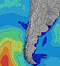 | 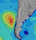 | 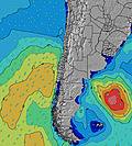 | 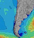 | 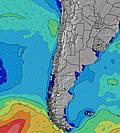 | ||||||||||||||
Wave Height (m) Direction Period (s) | WSW 12 | WSW 11 | WSW 11 | WSW 10 | WSW 10 | WSW 11 | SW 10 | SW 10 | SW 10 | SW 9 | SW 12 | SW 12 | SW 11 | WSW 11 | SW 10 | WSW 15 | WSW 14 | SW 18 | WSW 17 | SW 16 | SW 15 |
Wave Graph | |||||||||||||||||||||
288 | 259 | 240 | 281 | 360 | 513 | 450 | 441 | 348 | 115 | 306 | 614 | 439 | 389 | 243 | 188 | 180 | 330 | 355 | 587 | 509 | |
Wind (km/h) | |||||||||||||||||||||
Wind State on-shore cross-onshore cross-shore cross-offshore off-shore glassy | cross | cross | cross-off | cross | cross | cross-off | cross | cross | cross-off | cross | cross-on | cross-on | cross-on | on | glassy | cross-on | cross | glassy | glassy | cross | cross-off |
High Tide | 2:36PM1.05m | 4:28AM1.14m | 3:35PM0.96m | 5:32AM1.16m | 4:46PM0.90m | 6:29AM1.20m | 6:00PM0.88m | 7:16AM1.23m | 7:06PM0.89m | 7:56AM1.27m | 8:02PM0.93m | 8:31AM1.30m | 8:50PM0.96m | ||||||||
Low Tide | 9:08AM0.65m | 9:23PM0.30m | 10:29AM0.68m | 10:17PM0.34m | 11:52AM0.67m | 11:14PM0.37m | 1:01PM0.62m | 00:10AM0.38m | 1:53PM0.55m | 1:01AM0.39m | 2:33PM0.48m | 1:47AM0.40m | 3:09PM0.41m | 2:29AM0.41m | |||||||
7:20 | — | — | 7:20 | — | — | 7:20 | — | — | 7:20 | — | — | 7:20 | — | — | 7:18 | — | — | 7:18 | — | — | |
— | 6:14 | — | — | 6:15 | — | — | 6:15 | — | — | 6:15 | — | — | 6:15 | — | — | 6:15 | — | — | 6:16 | — | |
mm | — | — | — | — | — | — | — | — | — | — | — | — | — | — | — | — | — | — | — | — | — |
Temp °C | 19 | 18 | 17 | 19 | 19 | 18 | 20 | 19 | 20 | 24 | 23 | 18 | 18 | 18 | 17 | 18 | 19 | 16 | 18 | 19 | 18 |
Feels °C | 18 | 17 | 16 | 17 | 17 | 17 | 17 | 17 | 17 | 22 | 22 | 18 | 18 | 17 | 18 | 17 | 19 | 16 | 18 | 19 | 17 |
Swell 1 Height (m) Direction Period (s) | WSW 12 | WSW 11 | WSW 11 | WSW 10 | WSW 10 | WSW 11 | SW 10 | SW 10 | SW 10 | SW 7 | SW 8 | SW 12 | SW 11 | WSW 11 | SW 10 | WSW 10 | WSW 14 | SW 18 | WSW 17 | SW 16 | SW 12 |
288 | 259 | 240 | 281 | 360 | 513 | 450 | 441 | 348 | 115 | 111 | 614 | 439 | 389 | 243 | 118 | 180 | 330 | 355 | 587 | 319 | |
Swell 2 Height (m) Direction Period (s) | SSW 11 | SSW 11 | SW 11 | SSW 10 | WNW 20 | WNW 20 | SW 22 | SW 13 | SW 11 | SW 9 | SW 12 | WNW 17 | SW 17 | SW 16 | WSW 16 | WSW 15 | WSW 10 | WSW 13 | WSW 13 | SW 9 | SW 15 |
47 | 47 | 29 | 22 | 38 | 75 | 73 | 43 | 33 | 115 | 306 | 57 | 77 | 129 | 164 | 188 | 77 | 184 | 151 | 83 | 509 | |
Swell 3 Height (m) Direction Period (s) | W 21 | W 21 | WNW 21 | WNW 20 | SW 25 | SW 24 | WNW 19 | SW 22 | SW 20 | WNW 18 | SW 18 | SW 21 | WNW 17 | SW 20 | SW 20 | SSW 9 | SW 19 | WSW 10 | WSW 10 | W 14 | SW 6 |
9 | 35 | 43 | 39 | 25 | 87 | 72 | 73 | 97 | 62 | 50 | 71 | 54 | 99 | 61 | 32 | 173 | 54 | 52 | 16 | 15 | |
Wind waves Height (m) Direction Period (s) | — | — | — | — | — | — | — | — | — | — | — | — | — | — | — | — | — | — | — | — | — |
— | — | — | — | — | — | — | — | — | — | — | — | — | — | — | — | — | — | — | — | — | |
Nearest Offshore or Glassy | |||||||||||||||||||||
Distance (km) | 211 | 389 | 88 | 255 | 389 | 0 | 255 | 389 | 255 | 162 | 35 | 23 | 23 | 3 | 0 | 211 | 35 | 0 | 0 | 3 | 0 |
Best forecast wave conditions in Antofagasta | |||||||||||||||||||||
Best forecast wave conditions in Chile | |||||||||||||||||||||
Header Global | |||||||||||||||||||||
- Map Icons:
 Break
Break Live Wave Height (m)
 Live Wind Speed (km/h)
 Surf Rating (10 Max)
 Ocean Swells (m)
- Wind Speed (km/h)


FREE! Surf-Forecast.com widget for your website
The surf report / weather widget below is available to embed on third party websites free of charge and provides a summary of our La Puntilla surf forecast. Simply grab the html code snippet that we provide and paste it into your own site. You can choose your preferred language and metric/imperial units for the surf forecast feed to suit users of your site. Click here to get the code.
Information about the La Puntilla Surf forecast
The above surf forecast table for La Puntilla provides essential information for determining whether the surfing conditions will be good over the next 16 days. A general guide to surfing at La Puntilla can be found by selecting the local surf guide option on the grey menu. Our La Puntilla surf forecast is unique since it includes wave energy (power) that defines the real feel of the surf rather than just the height or the period. If you surf the same spot (La Puntilla) regularly then make a mental note of the wave energy from the surf forecast table each time you go. Very soon you may start to choose your surf days based on the wave energy alone combined with our forecast of favourable offshore wind conditions. Our star ratings will help here and of course you will also find the usual wave height and period predictions on our surf forecasts as well as a full break down of the swell components under our advanced users option (to reveal that, click the little Einstein character under the tide times).
Further information to help with frequently asked questions about our surf forecast for La Puntilla may be found under the help tab on the top menu and also by moving your mouse over the question marks on the surf forecast table itself. Please always bear in mind that the forecast is for near-shore open water and local factors at each surf break influence the actual breaking wave height, such as the beach / reef profile, water depths offshore and shelter.
Are you planning a holiday in Antofagasta? If you are looking for accommodation near La Puntilla, camping, hotels and holiday cottages in Antofagasta, consider staying in Antofagasta which is 6 km (4 miles) away. Alternatively, find information about places to stay and car hire in Mejillones which is 66 km (41 miles) away
 Nearest