

Surf Forecasts:

How big are the waves at K.O.A today (03 Aug):
- Morning surf: Morning surf (03 Aug, local time) - 0.5ft (0.1m), 13s period with E swell.
- Afternoon surf: Afternoon surf (03 Aug, local time) - 0.5ft (0.1m), 13s period with E swell.
- Evening surf: Evening surf (03 Aug, local time) - 0.5ft (0.1m), 13s period with E swell.
The current surf forecast for K.O.A at 10AM is: 0.1m 13s primary swell from a East direction (forecast issued at 07:00am August 03). An open ocean swell of 2.1m 7s is not directed at the surf break. The wind direction is predicted to be cross-offshore.
| Time (EDT) & Date | Wave Height | Wave Period |
|---|---|---|
| Morning (03 Aug) | 0.5ft (0.1m) | 13s |
| Afternoon (03 Aug) | 0.5ft (0.1m) | 13s |
| Evening (03 Aug) | 0.5ft (0.1m) | 13s |
Table - waves today at K.O.A. (Swell directed towards the surf break)
Short Range ForecastHeavy rain (total 84mm), heaviest during Mon afternoon. Warm (max 28°C on Wed night, min 24°C on Tue afternoon). Mainly strong winds. | |||||||||||||||||||||||
Monday 3 | Tuesday 4 | Wednesday 5 | |||||||||||||||||||||
5 AM | 8 AM | 11 AM | 2 PM | 5 PM | 8 PM | 11 PM | 2 AM | 5 AM | 8 AM | 11 AM | 2 PM | 5 PM | 8 PM | 11 PM | 2 AM | 5 AM | 8 AM | 11 AM | 2 PM | 5 PM | 8 PM | 11 PM | |
Swell Height Map |  | 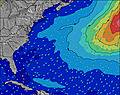 | 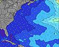 | 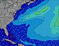 | 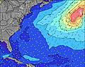 | 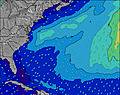 | 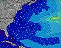 | 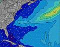 | 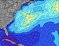 | ||||||||||||||
Wave Height (m) Direction Period (s) | E 13 | E 13 | E 13 | E 13 | E 13 | E 13 | E 13 | E 13 | E 13 | E 14 | SE 7 | SE 7 | SE 7 | SE 7 | SE 7 | ESE 7 | SE 7 | SE 7 | SE 7 | S 6 | S 6 | SE 7 | S 6 |
Wave Graph | |||||||||||||||||||||||
4 | 4 | 4 | 3 | 3 | 3 | 3 | 4 | 4 | 4 | 65 | 57 | 60 | 57 | 43 | 35 | 37 | 49 | 50 | 71 | 69 | 49 | 64 | |
Wind (km/h) | |||||||||||||||||||||||
Wind State on-shore cross-onshore cross-shore cross-offshore off-shore glassy | cross-off | cross-off | cross-off | cross-off | cross-off | cross-off | cross-off | cross-off | cross-off | cross-off | cross-off | cross-off | cross | cross-off | cross-off | cross-off | cross-off | cross-off | cross-off | cross-off | cross-off | cross-off | cross-off |
High Tide | 2:28PM0.21m | 2:09AM0.25m | 3:22PM0.22m | 2:46AM0.25m | 4:18PM0.22m | ||||||||||||||||||
Low Tide | 9:12AM0.11m | 8:01PM0.13m | 9:10AM0.10m | 8:38PM0.14m | 9:36AM0.09m | 9:23PM0.14m | |||||||||||||||||
6:11 | — | — | — | — | — | — | — | 6:11 | — | — | — | — | — | — | — | 6:11 | — | — | — | — | — | — | |
— | — | — | — | — | 8:04 | — | — | — | — | — | — | — | 8:02 | — | — | — | — | — | — | — | 8:01 | — | |
mm | 1 | 3 | 5 | 18 | 3 | 2 | 2 | 2 | 3 | 3 | 5 | 10 | 7 | 3 | 1 | 3 | 2 | 2 | 1 | 1 | — | — | — |
Temp °C | 28 | 26 | 25 | 25 | 25 | 25 | 26 | 26 | 26 | 25 | 25 | 24 | 25 | 25 | 26 | 26 | 27 | 27 | 27 | 27 | 27 | 28 | 27 |
Feels °C | 26 | 24 | 24 | 24 | 23 | 26 | 26 | 25 | 27 | 27 | 25 | 24 | 21 | 22 | 26 | 25 | 26 | 27 | 28 | 29 | 28 | 29 | 28 |
Swell 1 Height (m) Direction Period (s) | E 13 | E 13 | E 13 | E 13 | E 13 | E 13 | SSE 7 | E 13 | S 7 | S 7 | S 7 | SE 7 | SE 7 | SE 7 | S 6 | ESE 7 | SE 7 | SE 7 | SE 7 | ESE 7 | ESE 7 | SE 7 | ESE 7 |
4 | 4 | 4 | 3 | 3 | 3 | 238 | 4 | 310 | 209 | 96 | 57 | 60 | 57 | 95 | 35 | 37 | 49 | 50 | 33 | 32 | 49 | 31 | |
Swell 2 Height (m) Direction Period (s) | — | — | — | — | — | — | E 13 | — | E 13 | E 14 | SE 7 | E 12 | E 12 | E 12 | SE 7 | N 6 | NNE 6 | NNE 5 | NNE 5 | NNE 5 | NNE 5 | NE 5 | NE 5 |
— | — | — | — | — | — | 3 | — | 4 | 4 | 65 | 3 | 3 | 3 | 43 | 1 | 3 | 3 | 3 | 3 | 2 | 1 | 1 | |
Swell 3 Height (m) Direction Period (s) | — | — | — | — | — | — | — | — | — | — | — | — | — | — | E 8 | E 12 | E 12 | E 10 | E 9 | E 12 | E 9 | E 9 | E 11 |
— | — | — | — | — | — | — | — | — | — | — | — | — | — | 1 | 3 | 3 | 2 | 2 | 3 | 2 | 2 | 2 | |
Wind waves Height (m) Direction Period (s) | S 8 | S 7 | S 7 | S 7 | S 7 | SSE 7 | S 7 | S 7 | SSW 7 | — | SSW 7 | S 7 | SSW 7 | SSW 6 | — | S 6 | S 6 | S 6 | S 6 | S 6 | S 6 | S 6 | S 6 |
504 | 447 | 470 | 376 | 361 | 261 | 329 | 330 | 344 | — | 143 | 94 | 73 | 82 | — | 78 | 76 | 60 | 60 | 71 | 69 | 71 | 64 | |
Nearest Offshore or Glassy | |||||||||||||||||||||||
Distance (km) | 1185 | 334 | 159 | 155 | 328 | 264 | 144 | 63 | 39 | 7 | 68 | 278 | 145 | 380 | 582 | 145 | 144 | 144 | 145 | 0 | 68 | 145 | 476 |
Best forecast wave conditions in North Carolina | |||||||||||||||||||||||
Best forecast wave conditions in United States | |||||||||||||||||||||||
Header Global | |||||||||||||||||||||||
- Map Icons:
 Break
Break Live Wave Height (m)
 Live Wind Speed (km/h)
 Surf Rating (10 Max)
 Ocean Swells (m)
- Wind Speed (km/h)
Latest Updates


FREE! Surf-Forecast.com widget for your website
The surf report / weather widget below is available to embed on third party websites free of charge and provides a summary of our K.O.A surf forecast. Simply grab the html code snippet that we provide and paste it into your own site. You can choose your preferred language and metric/imperial units for the surf forecast feed to suit users of your site. Click here to get the code.
 Nearest