

Surf Forecasts:

Backyards surf forecast from 31 Jul 2026:
- Best quality surf: Friday 31 Jul, 6AM (local time) - 4.5ft (1.4m), 9s period, S swell with glassy winds.
- Most powerful swell: Friday 31 Jul, 3PM (local time) - 5ft (1.6m), 9s period, S swell with 445 kJ wave energy.
- Next surfable swell (1★+): Friday 31 Jul, 6AM (local time) - 4.5ft (1.4m), 9s period with S swell.
Best Forecast Surf Conditions for Backyards this week:
The surf forecast for Backyards over the next 16 days: The first swell (rated 1 star or higher) is forecast to arrive on Friday (Jul 31) at 6AM. The primary swell is predicted to be 1.4m and 9s period with a secondary swell of 0.6m and 6s. The wind is predicted to be glassy as the swell arrives.
The most powerful waves expected at Backyards in the next 16 days are 1.6m 9s and forecast to arrive on Friday (Jul 31) at 3PM. Winds are predicted to be onshore at the time the swell arrives. The largest open ocean swell (not directed at the beach) is 0.7m 5s period and expected on Friday (Aug 07) at 3AM.
| Wave Type | Time (ADT) & Date | Wave Height & Period |
|---|---|---|
| Next good surf (1 star+) | 6AM (Fri 31st Jul) | 4.5ft (1.4m) 9s |
| Best Surf | 6AM (Fri 31st Jul) | 4.5ft (1.4m) 9s |
| Most Powerful | 3PM (Fri 31st Jul) | 5ft (1.6m) 9s |
Table - best surf conditions forecast for Backyards over the next 16 days.
The Lowdown
Alright, Rusty here. Let’s break down what’s cookin’ for the local break.
We’ve got a bit of a slow start, but it fires up quick. The spot is Backyards, a reef break that’s exposed to the ESE swell and fairly consistent. The real winner is the Friday morning, July 31st. The wind is dead glassy out of the S at just 3 mph, and the water temp is about normal for this time of year. There’s a 5ft south swell running, with a period of 9 seconds, and the combined energy is 373 (moderate). The spot likes swell from the ESE, so the south direction isn’t perfect, but with those glassy conditions, it’s gonna be clean and fun. That’s the session to aim for.
Saturday morning, August 1st, the wind switches hard offshore from the NNW at 9 mph, which is a huge plus. The swell is still a solid 5ft from the south, energy at 312 (moderate). The period stays at 9 seconds, so it’s a nice little groundswell. It’ll be clean and lined up, but it’s not quite as punchy as the day before. That Friday morning is the standout.
After that, it’s a long, dry spell. From Sunday, August 2nd, the wind turns onshore or cross-shore, and the swell starts to fade fast. Sunday morning sees a 3ft south swell, period dropping to 8 seconds, with weak energy at 157. The conditions are poor, and it only gets worse. We’re looking at days of small, choppy, and messy surf all the way through the first week and into the second. The swell drops to 2ft or less, with energy readings in the double digits (34, 11, 31) – that’s weak, barely a ripple.
Late in the second week, there’s a tiny flicker of hope. Around Wednesday, August 12th, the wind goes clean offshore again, but the swell is tiny – 3ft from the south, with a period of only 4 seconds. The energy is just 43 (weak). It’s clean, but it’s ankle-biters. Thursday morning, August 13th, is similar with a 3ft swell from the SE, period 6 seconds, and a clean offshore breeze. The energy is still weak at 77. It’s a long way off, and the forecast could change, but as it stands, it’s more of a hopeful paddle than a proper session.
So, bottom line: you’ve got one solid window – Friday, July 31st morning. The rest of the 16 days is mostly a bust, with a couple of very small, clean days in the second week that are promising but far from certain. Get on that Friday glass-off.
Rusty.
Short Range ForecastLight rain (total 5mm), mostly falling on Fri night. Warm (max 23°C on Sat afternoon, min 17°C on Thu night). Wind will be generally light. | Days 5-7 Weather SummaryMostly dry. Warm (max 26°C on Wed afternoon, min 19°C on Sun night). Winds decreasing (fresh winds from the SW on Tue morning, light winds from the WSW by Wed afternoon). | ||||||||||||||||||
Friday 31 | Saturday 1 | Sunday 2 | Monday 3 | Tuesday 4 | Wednesday 5 | ||||||||||||||
Night | AM | PM | Night | AM | PM | Night | AM | PM | Night | AM | PM | Night | AM | PM | Night | AM | PM | Night | |
Swell Height Map | 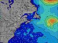 | 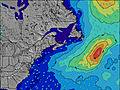 | 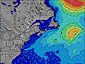 | 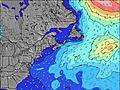 | 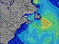 | 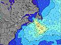 | 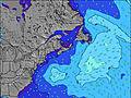 | ||||||||||||
Wave Height (m) Direction Period (s) | S 9 | S 9 | S 9 | S 9 | S 9 | S 9 | S 9 | S 8 | SSW 8 | SSW 8 | SSW 8 | SSW 7 | SSW 8 | SSW 7 | SSW 8 | SSW 8 | SSW 8 | SSW 7 | SSW 7 |
Wave Graph | |||||||||||||||||||
215 | 357 | 445 | 359 | 306 | 263 | 190 | 140 | 119 | 75 | 66 | 57 | 58 | 111 | 161 | 170 | 107 | 62 | 46 | |
Wind (km/h) | |||||||||||||||||||
Wind State on-shore cross-onshore cross-shore cross-offshore off-shore glassy | cross | glassy | on | cross-off | off | cross-off | glassy | cross-on | cross-on | cross | cross-on | cross-on | cross-on | cross-on | cross | cross-off | cross-off | cross | glassy |
High Tide | 9:33PM1.64m | 10:07AM1.56m | 10:11PM1.63m | 10:43AM1.59m | 10:50PM1.60m | 11:20AM1.61m | 11:31PM1.55m | 11:59AM1.61m | 00:15AM1.50m | 12:42PM1.61m | 1:05AM1.43m | 1:31PM1.60m | 2:04AM1.37m | ||||||
Low Tide | 4:18AM0.21m | 4:30PM0.39m | 4:51AM0.21m | 5:08PM0.36m | 5:24AM0.23m | 5:47PM0.34m | 6:00AM0.26m | 6:30PM0.33m | 6:39AM0.31m | 7:17PM0.33m | 7:23AM0.36m | 8:10PM0.34m | |||||||
— | 5:58 | — | — | 5:58 | — | — | 6:00 | — | — | 6:01 | — | — | 6:01 | — | — | 6:03 | — | — | |
8:42 | — | 8:40 | — | — | 8:38 | — | — | 8:37 | — | — | 8:37 | — | — | 8:35 | — | — | 8:34 | — | |
mm | 1 | — | 2 | 2 | — | — | — | — | — | — | — | — | — | — | — | — | — | — | — |
Temp °C | 18 | 19 | 20 | 19 | 20 | 23 | 20 | 22 | 22 | 20 | 22 | 23 | 20 | 20 | 22 | 21 | 24 | 26 | 24 |
Feels °C | 19 | 20 | 21 | 21 | 20 | 22 | 21 | 22 | 22 | 20 | 23 | 24 | 21 | 18 | 21 | 20 | 24 | 26 | 24 |
Swell 1 Height (m) Direction Period (s) | S 9 | S 9 | S 9 | S 9 | S 9 | S 9 | S 9 | S 8 | SSW 8 | SSW 8 | SSE 6 | SSE 6 | SSW 8 | SSW 7 | E 9 | SSW 8 | SSW 8 | SSW 7 | SSW 7 |
215 | 357 | 445 | 359 | 306 | 263 | 190 | 140 | 119 | 75 | 4 | 4 | 58 | 111 | 7 | 170 | 107 | 62 | 46 | |
Swell 2 Height (m) Direction Period (s) | ESE 6 | E 6 | E 6 | E 5 | ENE 5 | ENE 6 | E 6 | E 5 | SE 7 | SSE 7 | E 10 | SE 8 | E 10 | E 9 | SE 8 | E 9 | E 10 | E 10 | E 9 |
45 | 16 | 15 | 5 | 3 | 3 | 3 | 1 | 11 | 4 | 7 | 3 | 8 | 7 | 3 | 6 | 7 | 7 | 6 | |
Swell 3 Height (m) Direction Period (s) | — | — | — | SE 10 | SE 9 | SE 9 | SE 9 | E 8 | SE 9 | E 8 | SE 9 | E 9 | SE 8 | SE 8 | — | SE 8 | SE 8 | SE 8 | SE 8 |
— | — | — | 4 | 3 | 3 | 3 | 1 | 3 | 4 | 3 | 2 | 3 | 3 | — | 3 | 3 | 3 | 3 | |
Wind waves Height (m) Direction Period (s) | — | — | — | — | NW 3 | — | — | SW 5 | — | SW 5 | SSW 8 | SSW 7 | SSW 4 | — | SSW 8 | NW 3 | NW 3 | NNW 2 | — |
— | — | — | — | 2 | — | — | 15 | — | 23 | 66 | 57 | 13 | — | 161 | 1 | 2 | 1 | — | |
Nearest Offshore or Glassy | |||||||||||||||||||
Distance (km) | 5 | 0 | 609 | 0 | 0 | 0 | 0 | 22 | 1371 | 1837 | 594 | 981 | 594 | 794 | 771 | 22 | 0 | 2 | 0 |
Best forecast wave conditions in Nova Scotia | |||||||||||||||||||
Best forecast wave conditions in Canada | |||||||||||||||||||
Header Global | |||||||||||||||||||
- Map Icons:
 Break
Break Live Wave Height (m)
 Live Wind Speed (km/h)
 Surf Rating (10 Max)
 Ocean Swells (m)
- Wind Speed (km/h)
Latest Updates


FREE! Surf-Forecast.com widget for your website
The surf report / weather widget below is available to embed on third party websites free of charge and provides a summary of our Backyards surf forecast. Simply grab the html code snippet that we provide and paste it into your own site. You can choose your preferred language and metric/imperial units for the surf forecast feed to suit users of your site. Click here to get the code.
Information about the Backyards Surf forecast
The above surf forecast table for Backyards provides essential information for determining whether the surfing conditions will be good over the next 16 days. A general guide to surfing at Backyards can be found by selecting the local surf guide option on the grey menu. Our Backyards surf forecast is unique since it includes wave energy (power) that defines the real feel of the surf rather than just the height or the period. If you surf the same spot (Backyards) regularly then make a mental note of the wave energy from the surf forecast table each time you go. Very soon you may start to choose your surf days based on the wave energy alone combined with our forecast of favourable offshore wind conditions. Our star ratings will help here and of course you will also find the usual wave height and period predictions on our surf forecasts as well as a full break down of the swell components under our advanced users option (to reveal that, click the little Einstein character under the tide times).
Further information to help with frequently asked questions about our surf forecast for Backyards may be found under the help tab on the top menu and also by moving your mouse over the question marks on the surf forecast table itself. Please always bear in mind that the forecast is for near-shore open water and local factors at each surf break influence the actual breaking wave height, such as the beach / reef profile, water depths offshore and shelter.
Are you planning a holiday in Nova Scotia? If you are looking for accommodation near Backyards, camping, hotels and holiday cottages in Nova Scotia, consider staying in Cole Harbour which is 7 km (4 miles) away. Other places in and around Nova Scotia where you can find information about places to rent, and car hire include Dartmouth which is 11 km (7 miles) away, Halifax, Kings County and East Hants.
 Nearest