

Surf Forecasts:

Atlantic Terrace surf forecast from 3 Aug 2026:
- Best quality surf: Tuesday 4 Aug, 2AM (local time) - 5ft (1.6m), 8s period, S swell with cross-offshore winds.
- Most powerful swell: Monday 3 Aug, 2PM (local time) - 8ft (2.5m), 9s period, S swell with 1,051 kJ wave energy.
- Next surfable swell (1★+): Tuesday 4 Aug, 2AM (local time) - 5ft (1.6m), 8s period with S swell.
Best Forecast Surf Conditions for Atlantic Terrace this week:
The surf forecast for Atlantic Terrace over the next 16 days: The first swell (rated 1 star or higher) is forecast to arrive on Tuesday (Aug 04) at 2AM. The primary swell is predicted to be 1.6m and 8s period. The wind is predicted to be cross-offshore as the swell arrives.
The most powerful waves expected at Atlantic Terrace in the next 16 days are 2.5m 9s and forecast to arrive on Monday (Aug 03) at 2PM. Winds are predicted to be cross-shore at the time the swell arrives.
| Wave Type | Time (EDT) & Date | Wave Height & Period |
|---|---|---|
| Next good surf (1 star+) | 2AM (Tue 4th Aug) | 5ft (1.6m) 8s |
| Best Surf | 2AM (Tue 4th Aug) | 5ft (1.6m) 8s |
| Most Powerful | 2PM (Mon 3rd Aug) | 8ft (2.5m) 9s |
Table - best surf conditions forecast for Atlantic Terrace over the next 16 days.
The Lowdown
Alright folks, Rusty here. Let’s take a look at what’s on offer for Atlantic Terrace over the next couple of weeks. I’ll be straight with you – this is a tough stretch, and we’ve got a long wait ahead.
The first recommendation doesn’t come until Tuesday, the 4th of August. Before that, we’ve got a couple of days of total junk. Monday the 3rd is a write-off, with massive 8ft swell from the south, but a near gale cross-onshore wind is blowing it into a complete mess. Forget it. That’s a 2-day gap of nothing.
Now, Tuesday morning the 4th is our one real standout. It’s not big, but it’s clean. We’ve got a 4ft swell from the south with a period of 8 seconds, and the wind is glassy – dead calm. That’s the kind of morning you paddle out before anyone else. The combined wave energy is moderate (219), so there’s some push behind it. The water temp is about average for this time of year, nothing wild. This is a beach and reef setup, exposed to the south-east swell, so it’ll be picking up that energy. For a beginner, this is a perfect window. The crowd profile here says “often,” so expect a few heads out, but on a Tuesday morning with glass, it’ll be worth the company.
From there, things go downhill fast. Wednesday the 5th through to the end of the first week, we’re looking at a mix of heavy rain, cross-onshore winds, and lumpy, poor surf. The swell sticks around 5ft to 6ft but the wind is just wrong. The south winds are blowing it all to hell, and the period drops to 5–7 seconds, meaning weak, choppy junk. The combined energy is moderate at best, peaking at 350 on Wednesday afternoon, but with fresh cross-onshore wind, it’s just a mess.
The second week is even quieter. From Saturday the 8th onwards, the swell drops. We get a few mornings with clean conditions, like Saturday the 8th morning with a light cross-offshore and 3ft swell, but it’s tiny. The combined energy is weak (71). Then we have a long stretch of 2ft to 3ft waves, mostly with moderate cross-shore or cross-onshore wind, making it poor. The 15th of August, a Saturday, shows a bit of hope – 4ft swell from the south, with a clean cross-offshore and then a moderate offshore wind in the afternoon. Combined energy is moderate (134–138). That’s surfable, but small and not worth waiting two weeks for.
Honestly, for a setup like Atlantic Terrace, a blank run like this is more normal than you’d hope. The forecasts can change, but right now, the only window worth getting wet for is Tuesday morning the 4th. Get on it early, because it’s the only clean, glassy, small-wave day we’ve got.
Rusty.
Short Range ForecastHeavy rain (total 45mm), heaviest during Wed morning. Warm (max 25°C on Wed afternoon, min 20°C on Mon night). Winds decreasing (strong winds from the SSW on Mon morning, calm by Tue morning). | Days 5-7 Weather SummaryLight rain (total 6mm), mostly falling on Fri night. Warm (max 28°C on Sat afternoon, min 23°C on Wed night). Mainly fresh winds. | ||||||||||||||||||
Monday 3 | Tuesday 4 | Wednesday 5 | Thursday 6 | Friday 7 | Saturday 8 | ||||||||||||||
Night | AM | PM | Night | AM | PM | Night | AM | PM | Night | AM | PM | Night | AM | PM | Night | AM | PM | Night | |
Swell Height Map |  |  |  |  | 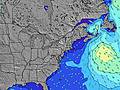 | 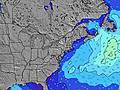 | 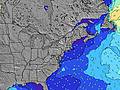 | ||||||||||||
Wave Height (m) Direction Period (s) | SSE 5 | S 8 | S 8 | S 8 | S 8 | S 8 | S 7 | SSE 5 | S 7 | S 7 | S 6 | S 6 | S 6 | SSW 7 | S 6 | SW 6 | S 6 | S 6 | SSW 6 |
Wave Graph | |||||||||||||||||||
43 | 1014 | 941 | 339 | 172 | 72 | 48 | 117 | 348 | 211 | 101 | 108 | 166 | 205 | 86 | 152 | 47 | 34 | 35 | |
Wind (km/h) | |||||||||||||||||||
Wind State on-shore cross-onshore cross-shore cross-offshore off-shore glassy | cross-on | cross-on | cross | cross-off | glassy | cross-on | cross | on | cross-on | cross | cross | cross | cross | cross | cross | cross | cross-off | cross-on | cross-off |
High Tide | 10:53PM0.80m | 11:24AM0.86m | 11:36PM0.76m | 12:08PM0.87m | 00:24AM0.72m | 12:59PM0.88m | 1:20AM0.68m | 1:59PM0.89m | 2:26AM0.65m | 3:09PM0.90m | 3:44AM0.66m | 4:31PM0.93m | |||||||
Low Tide | 4:55AM0.03m | 5:27PM0.13m | 5:36AM0.05m | 6:22PM0.15m | 6:22AM0.07m | 7:27PM0.17m | 7:17AM0.09m | 8:46PM0.17m | 8:21AM0.10m | 10:10PM0.14m | 9:33AM0.09m | 11:19PM0.09m | |||||||
— | 5:45 | — | — | 5:46 | — | — | 5:47 | — | — | 5:48 | — | — | 5:48 | — | — | 5:50 | — | — | |
8:02 | — | 8:01 | — | — | 8:00 | — | — | 8:00 | — | — | 7:58 | — | — | 7:57 | — | — | 7:55 | — | |
mm | 4 | 5 | 14 | 7 | — | — | — | 14 | 1 | — | 1 | — | — | — | — | 4 | — | 1 | 3 |
Temp °C | 24 | 24 | 23 | 23 | 22 | 24 | 24 | 24 | 25 | 24 | 26 | 26 | 25 | 27 | 27 | 25 | 25 | 28 | 27 |
Feels °C | 25 | 22 | 21 | 22 | 22 | 23 | 21 | 25 | 25 | 26 | 26 | 25 | 24 | 28 | 27 | 23 | 28 | 27 | 27 |
Swell 1 Height (m) Direction Period (s) | SE 7 | — | — | S 8 | S 8 | S 8 | S 7 | E 10 | E 10 | E 10 | — | SE 8 | ESE 8 | S 7 | SE 8 | S 6 | S 6 | SE 8 | SE 7 |
7 | — | — | 339 | 172 | 72 | 48 | 2 | 2 | 2 | — | 2 | 6 | 110 | 9 | 76 | 47 | 15 | 9 | |
Swell 2 Height (m) Direction Period (s) | SE 9 | — | — | — | SE 7 | SE 7 | SE 6 | — | — | — | E 11 | — | — | SE 8 | E 10 | SE 8 | SE 8 | E 8 | E 8 |
3 | — | — | — | 47 | 36 | 34 | — | — | — | 2 | — | — | 9 | 2 | 10 | 23 | 1 | 1 | |
Swell 3 Height (m) Direction Period (s) | — | — | — | — | — | — | E 12 | — | — | — | — | — | — | E 10 | — | E 9 | E 9 | — | — |
— | — | — | — | — | — | 3 | — | — | — | — | — | — | 2 | — | 2 | 1 | — | — | |
Wind waves Height (m) Direction Period (s) | SSE 5 | S 8 | S 8 | — | — | — | — | SSE 5 | S 7 | S 7 | S 6 | S 6 | S 6 | SSW 7 | S 6 | SW 6 | — | S 6 | SSW 6 |
43 | 1014 | 941 | — | — | — | — | 117 | 348 | 211 | 101 | 108 | 166 | 205 | 86 | 152 | — | 34 | 35 | |
Nearest Offshore or Glassy | |||||||||||||||||||
Distance (km) | 1193 | 1496 | 180 | 0 | 0 | 40 | 13 | 40 | 40 | 34 | 40 | 40 | 180 | 182 | 40 | 182 | 0 | 363 | 182 |
Best forecast wave conditions in Long Island New York | |||||||||||||||||||
Best forecast wave conditions in United States | |||||||||||||||||||
Header Global | |||||||||||||||||||
- Map Icons:
 Break
Break Live Wave Height (m)
 Live Wind Speed (km/h)
 Surf Rating (10 Max)
 Ocean Swells (m)
- Wind Speed (km/h)
Latest Updates


FREE! Surf-Forecast.com widget for your website
The surf report / weather widget below is available to embed on third party websites free of charge and provides a summary of our Atlantic Terrace surf forecast. Simply grab the html code snippet that we provide and paste it into your own site. You can choose your preferred language and metric/imperial units for the surf forecast feed to suit users of your site. Click here to get the code.
Information about the Atlantic Terrace Surf forecast
The above surf forecast table for Atlantic Terrace provides essential information for determining whether the surfing conditions will be good over the next 16 days. A general guide to surfing at Atlantic Terrace can be found by selecting the local surf guide option on the grey menu. Our Atlantic Terrace surf forecast is unique since it includes wave energy (power) that defines the real feel of the surf rather than just the height or the period. If you surf the same spot (Atlantic Terrace) regularly then make a mental note of the wave energy from the surf forecast table each time you go. Very soon you may start to choose your surf days based on the wave energy alone combined with our forecast of favourable offshore wind conditions. Our star ratings will help here and of course you will also find the usual wave height and period predictions on our surf forecasts as well as a full break down of the swell components under our advanced users option (to reveal that, click the little Einstein character under the tide times).
Further information to help with frequently asked questions about our surf forecast for Atlantic Terrace may be found under the help tab on the top menu and also by moving your mouse over the question marks on the surf forecast table itself. Please always bear in mind that the forecast is for near-shore open water and local factors at each surf break influence the actual breaking wave height, such as the beach / reef profile, water depths offshore and shelter.
Atlantic Terrace is 39 km (24 miles) from New London. If you plan a vacation in Long Island New York, look for hotels and other accommodation in New London. New London has rooms for a wide range of budgets as well as car hire and transport links.
 Nearest