

Surf Forecasts:

Rockaway surf forecast from 3 Aug 2026:
- Best quality surf: Monday 3 Aug, 8PM (local time) - 7.5ft (2.3m), 8s period, S swell with offshore winds.
- Most powerful swell: Monday 3 Aug, 8PM (local time) - 7.5ft (2.3m), 8s period, S swell with 697 kJ wave energy.
- Next surfable swell (1★+): Monday 3 Aug, 8PM (local time) - 7.5ft (2.3m), 8s period with S swell.
Best Forecast Surf Conditions for Rockaway this week:
The surf forecast for Rockaway over the next 16 days: The first swell (rated 1 star or higher) is forecast to arrive on Monday (Aug 03) at 8PM. The primary swell is predicted to be 2.3m and 8s period with a secondary swell of 1.6m and 8s. The wind is predicted to be offshore as the swell arrives.
The most powerful waves expected at Rockaway in the next 16 days are 2.3m 8s and forecast to arrive on Monday (Aug 03) at 8PM. Winds are predicted to be offshore at the time the swell arrives. The largest open ocean swell (not directed at the beach) is 0.4m 3s period and expected on Tuesday (Aug 04) at 2AM.
| Wave Type | Time (EDT) & Date | Wave Height & Period |
|---|---|---|
| Next good surf (1 star+) | 8PM (Mon 3rd Aug) | 7.5ft (2.3m) 8s |
| Best Surf | 8PM (Mon 3rd Aug) | 7.5ft (2.3m) 8s |
| Most Powerful | 8PM (Mon 3rd Aug) | 7.5ft (2.3m) 8s |
Table - best surf conditions forecast for Rockaway over the next 16 days.
The Lowdown
Alright folks, Rusty here. Let’s get real about what’s on the table for Rockaway. I’ve looked at the numbers, and honestly, it’s a tough stretch. We’re looking at a long, frustrating gap with no real surf to speak of.
The whole 16-day window is a flat spell. There’s nothing that qualifies as a proper surf session until we get to the very end. You’re looking at over a week of tiny, weak, and often wind-chopped junk. The water temperature is about average for this time of year, so that’s one small comfort.
The first sign of life doesn’t show up until Saturday, August 15th in the afternoon. The wind finally swings offshore from the NNW at 16 mph, cleaning things up. The swell is a weak 3 ft from the S, with a short period of 7 seconds, and the combined energy is a paltry 68 – that’s weak energy. It’s surfable, but only just. It’s a very ordinary, knee-high dribbler.
Then, on Monday, August 18th in the morning, we get one more chance. The wind is a clean cross-offshore from the WSW at 9 mph. Again, the swell is tiny at 3 ft from the S, period is a miserable 5 seconds, and the energy is a very weak 53. It’s clean, but it’s barely a wave.
Nothing else in this whole forecast is worth paddling out for. The wind is predominantly onshore or cross-shore, and the swell is just too small and weak to do anything with. For a break like Rockaway, a run this poor is more normal than you’d hope. It’s the kind of window where you check the cams, see the limp lumps, and go back to organizing your wetsuits.
Hang in there. The forecasts can change, but right now, this is a long wait for a couple of marginal sessions.
Rusty
Short Range ForecastHeavy rain (total 47mm), heaviest during Wed morning. Warm (max 26°C on Sun night, min 22°C on Mon night). Winds decreasing (fresh winds from the SSW on Mon morning, light winds from the ESE by Tue morning). | Days 5-7 Weather SummaryModerate rain (total 10mm), heaviest on Fri night. Warm (max 32°C on Fri afternoon, min 24°C on Thu morning). Winds decreasing (fresh winds from the S on Thu afternoon, calm by Fri night). | ||||||||||||||||||
Monday 3 | Tuesday 4 | Wednesday 5 | Thursday 6 | Friday 7 | Saturday 8 | ||||||||||||||
Night | AM | PM | Night | AM | PM | Night | AM | PM | Night | AM | PM | Night | AM | PM | Night | AM | PM | Night | |
Swell Height Map |  |  |  |  | 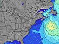 | 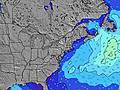 | 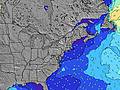 | ||||||||||||
Wave Height (m) Direction Period (s) | SSE 5 | SSE 8 | S 8 | SSE 8 | SSE 7 | S 7 | SE 7 | SSE 7 | S 7 | S 7 | SSE 6 | S 6 | S 6 | SSE 7 | S 6 | SSE 6 | S 6 | SSE 6 | S 6 |
Wave Graph | |||||||||||||||||||
44 | 402 | 393 | 159 | 84 | 37 | 69 | 168 | 220 | 107 | 64 | 146 | 170 | 73 | 78 | 62 | 27 | 53 | 102 | |
Wind (km/h) | |||||||||||||||||||
Wind State on-shore cross-onshore cross-shore cross-offshore off-shore glassy | cross-on | cross | cross-off | cross-off | cross-on | on | on | cross-on | cross-off | cross | cross | cross-on | cross | cross | cross-on | cross-on | cross-off | cross-on | cross-off |
High Tide | 10:41PM1.47m | 11:14AM1.46m | 11:27PM1.41m | 12:00PM1.50m | 00:19AM1.34m | 12:51PM1.53m | 1:16AM1.29m | 1:47PM1.55m | 2:19AM1.24m | 2:49PM1.58m | 3:29AM1.24m | 3:58PM1.61m | 4:41AM1.28m | ||||||
Low Tide | 5:00AM0.02m | 5:25PM0.20m | 5:35AM0.05m | 6:15PM0.23m | 6:19AM0.10m | 7:22PM0.27m | 7:16AM0.14m | 8:39PM0.26m | 8:29AM0.17m | 9:51PM0.20m | 9:42AM0.15m | 10:55PM0.12m | |||||||
— | 5:52 | — | — | 5:54 | — | — | 5:54 | — | — | 5:56 | — | — | 5:56 | — | — | 5:58 | — | — | |
8:08 | — | 8:07 | — | — | 8:07 | — | — | 8:06 | — | — | 8:05 | — | — | 8:04 | — | — | 8:01 | — | |
mm | 7 | 9 | 8 | 5 | — | — | 1 | 14 | 3 | 1 | — | — | — | — | — | 9 | — | — | 4 |
Temp °C | 26 | 25 | 26 | 26 | 23 | 25 | 25 | 24 | 25 | 26 | 27 | 30 | 30 | 29 | 32 | 31 | 27 | 30 | 29 |
Feels °C | 27 | 24 | 26 | 27 | 23 | 24 | 26 | 24 | 25 | 29 | 29 | 28 | 29 | 31 | 32 | 32 | 29 | 31 | 28 |
Swell 1 Height (m) Direction Period (s) | SE 9 | — | — | SSE 8 | SSE 7 | S 7 | SE 7 | E 12 | SSE 7 | E 11 | — | E 11 | S 6 | SSE 7 | SE 7 | SSE 6 | S 6 | SE 8 | SSE 6 |
3 | — | — | 159 | 84 | 37 | 69 | 3 | 149 | 2 | — | 2 | 109 | 73 | 8 | 62 | 27 | 28 | 60 | |
Swell 2 Height (m) Direction Period (s) | — | — | — | — | ESE 7 | — | — | — | — | — | — | — | — | — | — | E 9 | SE 8 | E 8 | E 9 |
— | — | — | — | 59 | — | — | — | — | — | — | — | — | — | — | 2 | 16 | 1 | 2 | |
Swell 3 Height (m) Direction Period (s) | — | — | — | — | — | — | — | — | — | — | — | — | — | — | — | — | E 9 | — | — |
— | — | — | — | — | — | — | — | — | — | — | — | — | — | — | — | 2 | — | — | |
Wind waves Height (m) Direction Period (s) | SSE 5 | SSE 8 | S 8 | NNE 3 | — | SE 7 | SE 7 | SSE 7 | S 7 | S 7 | SSE 6 | S 6 | S 6 | — | S 6 | — | — | SSE 6 | S 6 |
44 | 402 | 393 | 3 | — | 33 | 59 | 168 | 220 | 107 | 64 | 146 | 170 | — | 78 | — | — | 53 | 102 | |
Nearest Offshore or Glassy | |||||||||||||||||||
Distance (km) | 1054 | 1366 | 19 | 0 | 45 | 195 | 177 | 195 | 30 | 17 | 17 | 195 | 17 | 24 | 195 | 24 | 24 | 225 | 24 |
Best forecast wave conditions in Long Island New York | |||||||||||||||||||
Best forecast wave conditions in United States | |||||||||||||||||||
Header Global | |||||||||||||||||||
- Map Icons:
 Break
Break Live Wave Height (m)
 Live Wind Speed (km/h)
 Surf Rating (10 Max)
 Ocean Swells (m)
- Wind Speed (km/h)
Latest Updates


FREE! Surf-Forecast.com widget for your website
The surf report / weather widget below is available to embed on third party websites free of charge and provides a summary of our Rockaway surf forecast. Simply grab the html code snippet that we provide and paste it into your own site. You can choose your preferred language and metric/imperial units for the surf forecast feed to suit users of your site. Click here to get the code.
Information about the Rockaway Surf forecast
The above surf forecast table for Rockaway provides essential information for determining whether the surfing conditions will be good over the next 16 days. A general guide to surfing at Rockaway can be found by selecting the local surf guide option on the grey menu. Our Rockaway surf forecast is unique since it includes wave energy (power) that defines the real feel of the surf rather than just the height or the period. If you surf the same spot (Rockaway) regularly then make a mental note of the wave energy from the surf forecast table each time you go. Very soon you may start to choose your surf days based on the wave energy alone combined with our forecast of favourable offshore wind conditions. Our star ratings will help here and of course you will also find the usual wave height and period predictions on our surf forecasts as well as a full break down of the swell components under our advanced users option (to reveal that, click the little Einstein character under the tide times).
Further information to help with frequently asked questions about our surf forecast for Rockaway may be found under the help tab on the top menu and also by moving your mouse over the question marks on the surf forecast table itself. Please always bear in mind that the forecast is for near-shore open water and local factors at each surf break influence the actual breaking wave height, such as the beach / reef profile, water depths offshore and shelter.
Rockaway is 11 km (7 miles) from the city of East New York. If you plan a vacation in Long Island New York, look for hotels and other accommodation in East New York. East New York has rooms for a wide range of budgets as well as car hire and transport links.
 Nearest