

Surf Forecasts:

Short Range ForecastModerate rain (total 13mm), heaviest on Mon afternoon. Warm (max 27°C on Mon night, min 23°C on Mon night). Wind will be generally light. | ||||||||||||||||||||||||
Monday 3 | Tuesday 4 | Wednesday 5 | ||||||||||||||||||||||
2 AM | 5 AM | 8 AM | 11 AM | 2 PM | 5 PM | 8 PM | 11 PM | 2 AM | 5 AM | 8 AM | 11 AM | 2 PM | 5 PM | 8 PM | 11 PM | 2 AM | 5 AM | 8 AM | 11 AM | 2 PM | 5 PM | 8 PM | 11 PM | |
Swell Height Map | 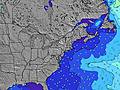 | 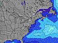 |  | 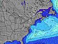 | 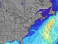 |  | 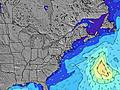 | 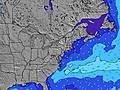 |  | |||||||||||||||
Wave Height (m) Direction Period (s) | SSE 7 | S 8 | S 8 | SSE 8 | SSE 8 | S 8 | S 8 | S 8 | NE 3 | NE 4 | ENE 4 | ENE 5 | ENE 5 | SE 6 | ESE 5 | ESE 7 | SE 7 | ESE 7 | ESE 7 | ESE 7 | ESE 7 | SE 7 | SE 7 | SE 7 |
Wave Graph | ||||||||||||||||||||||||
0 | 0 | 0 | 0 | 0 | 0 | 0 | 0 | 4 | 15 | 32 | 38 | 39 | 46 | 42 | 74 | 112 | 51 | 41 | 38 | 31 | 29 | 23 | 15 | |
Wind (km/h) | ||||||||||||||||||||||||
Wind State on-shore cross-onshore cross-shore cross-offshore off-shore glassy | cross-off | cross-off | cross-off | cross-off | cross-off | cross-off | cross-off | cross-off | cross-on | cross-on | on | cross-on | cross-on | cross-on | cross-on | on | on | cross-on | cross-on | glassy | cross-off | cross-off | cross-off | cross-off |
High Tide | 11:19AM1.32m | 11:31PM1.28m | 12:05PM1.36m | 00:18AM1.20m | 12:57PM1.39m | |||||||||||||||||||
Low Tide | 5:06AM0.05m | 5:28PM0.18m | 5:46AM0.06m | 6:23PM0.20m | 6:31AM0.08m | 7:26PM0.22m | ||||||||||||||||||
— | 5:58 | — | — | — | — | — | — | — | 5:58 | — | — | — | — | — | — | — | 6:00 | — | — | — | — | — | — | |
— | — | — | — | — | — | 8:07 | — | — | — | — | — | — | — | 8:07 | — | — | — | — | — | — | — | 8:06 | — | |
mm | 2 | 2 | 3 | 2 | 4 | 1 | 1 | — | — | — | — | — | — | — | — | — | — | — | — | 1 | — | 1 | — | — |
Temp °C | 25 | 24 | 24 | 24 | 24 | 26 | 27 | 26 | 24 | 23 | 23 | 24 | 24 | 24 | 23 | 23 | 23 | 23 | 23 | 23 | 25 | 26 | 26 | 26 |
Feels °C | 25 | 24 | 25 | 25 | 26 | 28 | 29 | 28 | 23 | 22 | 21 | 22 | 21 | 22 | 22 | 24 | 25 | 25 | 25 | 27 | 28 | 29 | 28 | 28 |
Swell 1 Height (m) Direction Period (s) | — | — | — | SSE 8 | SSE 8 | SSE 8 | S 8 | S 8 | SSE 8 | SSE 7 | SSE 7 | S 7 | SE 6 | SE 6 | S 7 | ESE 7 | SE 7 | ESE 7 | S 7 | S 7 | S 6 | S 6 | SE 7 | SE 7 |
— | — | — | 522 | 483 | 509 | 488 | 333 | 202 | 164 | 114 | 65 | 39 | 46 | 49 | 74 | 112 | 51 | 47 | 43 | 29 | 27 | 23 | 15 | |
Swell 2 Height (m) Direction Period (s) | — | — | — | — | — | — | — | — | — | — | — | SE 7 | S 7 | S 7 | E 8 | S 7 | E 9 | S 7 | ESE 7 | ESE 7 | ESE 7 | SE 7 | E 4 | — |
— | — | — | — | — | — | — | — | — | — | — | 33 | 48 | 47 | 1 | 51 | 2 | 52 | 41 | 38 | 31 | 29 | 1 | — | |
Swell 3 Height (m) Direction Period (s) | — | — | — | — | — | — | — | — | — | — | — | — | — | E 8 | — | E 9 | — | E 9 | E 8 | E 11 | — | E 4 | E 10 | E 10 |
— | — | — | — | — | — | — | — | — | — | — | — | — | 1 | — | 2 | — | 2 | 1 | 2 | — | 1 | 2 | 2 | |
Wind waves Height (m) Direction Period (s) | SSE 7 | S 8 | S 8 | — | — | S 8 | S 8 | — | NE 3 | NE 4 | ENE 4 | ENE 5 | ENE 5 | NE 4 | ESE 5 | — | — | — | — | — | — | — | S 6 | S 6 |
332 | 643 | 562 | — | — | 737 | 682 | — | 4 | 15 | 32 | 38 | 32 | 16 | 42 | — | — | — | — | — | — | — | 47 | 69 | |
Nearest Offshore or Glassy | ||||||||||||||||||||||||
Distance (km) | 1001 | 1054 | 1001 | 108 | 29 | 15 | 15 | 1 | 67 | 145 | 126 | 168 | 288 | 305 | 168 | 148 | 27 | 27 | 64 | 28 | 29 | 32 | 43 | 36 |
Best forecast wave conditions in New Jersey | ||||||||||||||||||||||||
Best forecast wave conditions in United States | ||||||||||||||||||||||||
Header Global | ||||||||||||||||||||||||
- Map Icons:
 Break
Break Live Wave Height (m)
 Live Wind Speed (km/h)
 Surf Rating (10 Max)
 Ocean Swells (m)
- Wind Speed (km/h)
Latest Updates


FREE! Surf-Forecast.com widget for your website
The surf report / weather widget below is available to embed on third party websites free of charge and provides a summary of our Crystals surf forecast. Simply grab the html code snippet that we provide and paste it into your own site. You can choose your preferred language and metric/imperial units for the surf forecast feed to suit users of your site. Click here to get the code.
 Nearest