

Surf Forecasts:

Masonboro Inlet surf forecast from 2 Aug 2026:
- Best quality surf: Wednesday 5 Aug, 8AM (local time) - 3.5ft (1.0m), 6s period, SE swell with glassy winds.
- Most powerful swell: Sunday 2 Aug, 11AM (local time) - 4.5ft (1.4m), 6s period, SSE swell with 131 kJ wave energy.
- Next surfable swell (1★+): Wednesday 5 Aug, 8AM (local time) - 3.5ft (1.0m), 6s period with SE swell.
Best Forecast Surf Conditions for Masonboro Inlet this week:
The surf forecast for Masonboro Inlet over the next 16 days: The first swell (rated 1 star or higher) is forecast to arrive on Wednesday (Aug 05) at 8AM. The primary swell is predicted to be 1.0m and 6s period with a secondary swell of 0.2m and 5s. The wind is predicted to be glassy as the swell arrives.
The most powerful waves expected at Masonboro Inlet in the next 16 days are 1.4m 6s and forecast to arrive on Sunday (Aug 02) at 11AM. Winds are predicted to be cross-onshore at the time the swell arrives. The largest open ocean swell (not directed at the beach) is 2.1m 8s period and expected on Sunday (Aug 02) at 8PM.
| Wave Type | Time (EDT) & Date | Wave Height & Period |
|---|---|---|
| Next good surf (1 star+) | 8AM (Wed 5th Aug) | 3.5ft (1.0m) 6s |
| Best Surf | 8AM (Wed 5th Aug) | 3.5ft (1.0m) 6s |
| Most Powerful | 11AM (Sun 2nd Aug) | 4.5ft (1.4m) 6s |
Table - best surf conditions forecast for Masonboro Inlet over the next 16 days.
The Lowdown
Alright folks, Rusty here. Let's be straight with ya – lookin' at Masonboro Inlet, it's gonna be a tough stretch for any decent paddle surfing. The whole sixteen-day window is a bit of a write-off, I hate to say it. There’s just no real goodness on offer.
Right now, and for the next two weeks plus, it’s a whole lot of small, weak, and messy. The wind is mostly onshore or cross-onshore from the south and southeast, often blowing moderate to fresh (around 12 to 22 mph). This is clobbering any chance of clean waves. We get a few little pulses of swell – typically around 3 ft to 3 ft from the SSE or SE, with a short, weak period of just 4 to 7 seconds. The combined swell energy is mostly low, often below 100 (like 24 or 97) – basically no grunt behind it. It’s the kind of setup that looks more interesting for kite surfing than paddle surfing, to be honest.
There is one little window that catches the eye, but you gotta wait for it. On Thursday morning, August 13th, things look a bit different. We’ve got a tiny 4 ft swell from the SW with a weak 5-second period (88 combined energy), but the wind goes calm and glassy. That’s a huge positive – the surface will be like a pond. But the swell is so small and weak it’s labelled as just “surfable waves but very ordinary conditions”. For a dedicated soul on a log, it might be the only time you can get a couple of weak, clean crumbles.
After that, it dries right up again. From the 14th into the 16th, we’re back to tiny dribble – 1 ft to 3 ft – with onshore winds and barely any energy. The water temp is about 82°, which is pretty much average for this time of year up here in North Carolina. Look, if you’re desperate, that glassy Thursday morning is your only real chance, but don't expect much. It’s a lean forecast.
Rusty.
Short Range ForecastHeavy rain (total 66mm), heaviest during Mon morning. Warm (max 28°C on Sat afternoon, min 25°C on Sun night). Winds decreasing (fresh winds from the SSW on Sun night, light winds from the SW by Tue morning). | Days 5-7 Weather SummaryLight rain (total 8mm), mostly falling on Tue afternoon. Warm (max 29°C on Wed afternoon, min 27°C on Tue afternoon). Wind will be generally light. | |||||||||||||||||||
Sat 1 | Sunday 2 | Monday 3 | Tuesday 4 | Wednesday 5 | Thursday 6 | Friday 7 | ||||||||||||||
PM | Night | AM | PM | Night | AM | PM | Night | AM | PM | Night | AM | PM | Night | AM | PM | Night | AM | PM | Night | |
Swell Height Map | 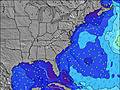 | 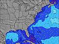 | 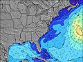 | 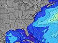 | 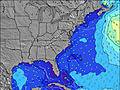 | 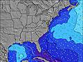 | 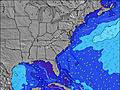 | |||||||||||||
Wave Height (m) Direction Period (s) | SSE 4 | SSE 5 | SSE 6 | SSE 7 | S 8 | S 8 | S 7 | SE 7 | SE 7 | SE 6 | SE 6 | SE 6 | SE 6 | SSE 6 | ESE 7 | SE 6 | SE 6 | SE 7 | SE 7 | SE 8 |
Wave Graph | ||||||||||||||||||||
24 | 58 | 131 | 0 | 0 | 0 | 0 | 42 | 63 | 51 | 70 | 78 | 75 | 63 | 30 | 40 | 52 | 67 | 73 | 101 | |
Wind (km/h) | ||||||||||||||||||||
Wind State on-shore cross-onshore cross-shore cross-offshore off-shore glassy | on | cross-on | cross-on | cross-on | cross | cross | cross-on | cross | cross | cross | cross-on | cross-on | cross-on | cross-on | on | on | cross-on | on | on | on |
High Tide | 10:34PM1.23m | 10:55AM1.17m | 11:10PM1.19m | 11:39AM1.20m | 11:51PM1.15m | 12:30PM1.23m | 00:40AM1.09m | 1:28PM1.24m | 1:39AM1.04m | 2:33PM1.26m | 2:47AM1.01m | 3:42PM1.29m | 4:01AM1.01m | |||||||
Low Tide | 4:41PM0.09m | 5:13AM0.05m | 5:23PM0.12m | 5:51AM0.05m | 6:10PM0.16m | 6:33AM0.05m | 7:04PM0.20m | 7:22AM0.06m | 8:06PM0.23m | 8:20AM0.06m | 9:16PM0.25m | 9:26AM0.06m | 10:28PM0.24m | |||||||
— | — | 6:22 | — | — | 6:22 | — | — | 6:24 | — | — | 6:24 | — | — | 6:24 | — | — | 6:26 | — | — | |
8:12 | — | — | 8:10 | — | — | 8:09 | — | — | 8:09 | — | — | 8:08 | — | — | 8:07 | — | — | 8:07 | — | |
mm | — | 4 | 4 | 5 | 11 | 16 | 7 | 11 | 8 | 3 | 2 | — | — | 1 | 1 | — | 1 | — | 1 | — |
Temp °C | 28 | 27 | 28 | 28 | 26 | 25 | 26 | 26 | 27 | 28 | 27 | 28 | 29 | 28 | 28 | 29 | 28 | 28 | 28 | 27 |
Feels °C | 28 | 28 | 29 | 28 | 24 | 25 | 27 | 25 | 30 | 29 | 29 | 31 | 30 | 31 | 31 | 31 | 31 | 31 | 30 | 30 |
Swell 1 Height (m) Direction Period (s) | — | ESE 9 | — | — | — | — | — | SE 7 | SE 7 | SE 6 | SE 6 | SE 6 | SE 6 | — | ESE 7 | SE 6 | E 10 | SE 7 | SE 7 | SE 8 |
— | 8 | — | — | — | — | — | 42 | 63 | 51 | 70 | 78 | 75 | — | 30 | 40 | 2 | 67 | 73 | 101 | |
Swell 2 Height (m) Direction Period (s) | — | — | — | — | — | — | — | — | — | S 6 | SSW 6 | — | — | — | S 5 | E 10 | E 11 | E 10 | E 9 | E 9 |
— | — | — | — | — | — | — | — | — | 3 | 6 | — | — | — | 13 | 2 | 2 | 2 | 2 | 1 | |
Swell 3 Height (m) Direction Period (s) | — | — | — | — | — | — | — | — | — | — | — | — | — | — | E 11 | — | — | — | — | — |
— | — | — | — | — | — | — | — | — | — | — | — | — | — | 2 | — | — | — | — | — | |
Wind waves Height (m) Direction Period (s) | SSE 4 | SSE 5 | SSE 6 | SSE 7 | S 8 | S 8 | S 7 | S 7 | SSW 6 | SSW 6 | — | SSW 5 | SSW 5 | SSE 6 | — | — | SE 6 | — | — | — |
24 | 58 | 131 | 365 | 517 | 299 | 278 | 107 | 51 | 46 | — | 3 | 3 | 63 | — | — | 52 | — | — | — | |
Nearest Offshore or Glassy | ||||||||||||||||||||
Distance (km) | 835 | 1188 | 740 | 1753 | 575 | 370 | 579 | 2 | 84 | 278 | 305 | 283 | 929 | 1148 | 282 | 2169 | 752 | 335 | 154 | 154 |
Best forecast wave conditions in North Carolina | ||||||||||||||||||||
Best forecast wave conditions in United States | ||||||||||||||||||||
Header Global | ||||||||||||||||||||
- Map Icons:
 Break
Break Live Wave Height (m)
 Live Wind Speed (km/h)
 Surf Rating (10 Max)
 Ocean Swells (m)
- Wind Speed (km/h)
Latest Updates


FREE! Surf-Forecast.com widget for your website
The surf report / weather widget below is available to embed on third party websites free of charge and provides a summary of our Masonboro Inlet surf forecast. Simply grab the html code snippet that we provide and paste it into your own site. You can choose your preferred language and metric/imperial units for the surf forecast feed to suit users of your site. Click here to get the code.
Information about the Masonboro Inlet Surf forecast
The above surf forecast table for Masonboro Inlet provides essential information for determining whether the surfing conditions will be good over the next 16 days. A general guide to surfing at Masonboro Inlet can be found by selecting the local surf guide option on the grey menu. Our Masonboro Inlet surf forecast is unique since it includes wave energy (power) that defines the real feel of the surf rather than just the height or the period. If you surf the same spot (Masonboro Inlet) regularly then make a mental note of the wave energy from the surf forecast table each time you go. Very soon you may start to choose your surf days based on the wave energy alone combined with our forecast of favourable offshore wind conditions. Our star ratings will help here and of course you will also find the usual wave height and period predictions on our surf forecasts as well as a full break down of the swell components under our advanced users option (to reveal that, click the little Einstein character under the tide times).
Further information to help with frequently asked questions about our surf forecast for Masonboro Inlet may be found under the help tab on the top menu and also by moving your mouse over the question marks on the surf forecast table itself. Please always bear in mind that the forecast is for near-shore open water and local factors at each surf break influence the actual breaking wave height, such as the beach / reef profile, water depths offshore and shelter.
Masonboro Inlet is 13 km (8 miles) from the city of Wilmington. If you plan a vacation in North Carolina, look for hotels and other accommodation in Wilmington. Wilmington has rooms for a wide range of budgets as well as car hire and transport links.
 Nearest