

Surf Forecasts:

Sandy Hook/The Cove surf forecast from 3 Aug 2026:
- Best quality surf: Monday 3 Aug, 5PM (local time) - 2.5ft (0.7m), 8s period, SE swell with offshore winds.
- Most powerful swell: Thursday 6 Aug, 11PM (local time) - 4.5ft (1.3m), 6s period, S swell with 128 kJ wave energy.
- Next surfable swell (1★+): Monday 3 Aug, 5PM (local time) - 2.5ft (0.7m), 8s period with SE swell.
Best Forecast Surf Conditions for Sandy Hook/The Cove this week:
The surf forecast for Sandy Hook/The Cove over the next 16 days: The first swell (rated 1 star or higher) is forecast to arrive on Monday (Aug 03) at 5PM. The primary swell is predicted to be 0.7m and 8s period. The wind is predicted to be offshore as the swell arrives.
The most powerful waves expected at Sandy Hook/The Cove in the next 16 days are 1.3m 6s and forecast to arrive on Thursday (Aug 06) at 11PM. Winds are predicted to be cross-offshore at the time the swell arrives. The largest open ocean swell (not directed at the beach) is 0.8m 6s period and expected on Friday (Aug 07) at 8PM.
| Wave Type | Time (EDT) & Date | Wave Height & Period |
|---|---|---|
| Next good surf (1 star+) | 5PM (Mon 3rd Aug) | 2.5ft (0.7m) 8s |
| Best Surf | 5PM (Mon 3rd Aug) | 2.5ft (0.7m) 8s |
| Most Powerful | 11PM (Thu 6th Aug) | 4.5ft (1.3m) 6s |
Table - best surf conditions forecast for Sandy Hook/The Cove over the next 16 days.
The Lowdown
Alright, let's get into it. The outlook for Sandy Hook/The Cove is pretty grim. We're looking at a long stretch with very little to get excited about. The water is running a touch warmer than normal at 76°, about 3° above average, which is nice for a dip but won't help the waves.
The first bit of hope comes on Monday the 3rd of August. We've got a 3ft SSE swell pushing in with a short period, giving us moderate energy (128). The morning is a bit of a write-off with a risk of thunderstorms and a cross-off wind, but it’s surfable. The real potential is Monday afternoon. The wind swings to a clean WSW offshore at 9 mph, and while the swell drops to 2ft from the SE, it’s clean. It’s the only time in this whole forecast that things come together.
Tuesday the 4th is a no-go from the start with onshore winds and tiny surf. Wednesday the 5th starts glassy, but with only 2ft on offer, there’s just nothing to work with. The rest of the first week and into the second is a dead zone. The swell is tiny, under 2ft, and the wind is either onshore or cross-shore. It’s a total blank run from Wednesday afternoon right through to the end of the second week.
The only real standout is that Monday afternoon window. The break is a beach and reef setup, fairly exposed to the ESE swell, and it can get crowded sometimes. But for this one, with the offshore wind and a clean 2ft wave, it’s your best bet. The crowd won't be as bad with such a small window.
For beginner surfers, the swell never gets above 5ft, so it’s never too big, but it’s also never good enough. The short period swells mean the waves will be weak and crumbly. For the experienced crew, there’s just nothing to sink your teeth into.
This is a tough stretch. The surf is essentially non-existent for days on end. It’s the kind of blank run that’s more normal for this area when the swells are this small. The forecast can change, but right now, it’s a waiting game.
Rusty.
Short Range ForecastModerate rain (total 10mm), heaviest on Mon morning. Warm (max 29°C on Mon afternoon, min 23°C on Mon night). Wind will be generally light. | Days 4-6 Weather SummaryLight rain (total 5mm), mostly falling on Sat night. Warm (max 34°C on Fri night, min 24°C on Thu morning). Wind will be generally light. | ||||||||||||||||||||
Monday 3 | Tuesday 4 | Wednesday 5 | Thursday 6 | Friday 7 | Saturday 8 | Sunday 9 | |||||||||||||||
AM | PM | Night | AM | PM | Night | AM | PM | Night | AM | PM | Night | AM | PM | Night | AM | PM | Night | AM | PM | Night | |
Swell Height Map | 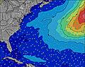 | 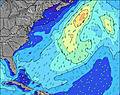 | 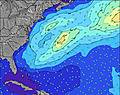 | 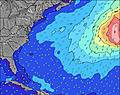 | 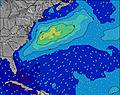 | 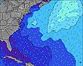 | 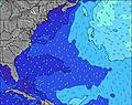 | ||||||||||||||
Wave Height (m) Direction Period (s) | SSE 8 | SE 8 | SE 8 | SE 7 | S 7 | SE 8 | SE 7 | SE 7 | SE 6 | S 6 | E 11 | SSE 6 | SSE 6 | SSE 6 | SSE 5 | SSE 6 | SE 8 | SE 7 | SSE 6 | SSE 6 | SSE 6 |
Wave Graph | |||||||||||||||||||||
128 | 72 | 54 | 26 | 37 | 57 | 23 | 35 | 7 | 76 | 2 | 30 | 15 | 14 | 11 | 7 | 9 | 8 | 7 | 8 | 12 | |
Wind (km/h) | |||||||||||||||||||||
Wind State on-shore cross-onshore cross-shore cross-offshore off-shore glassy | cross-off | off | cross-on | on | cross-on | cross-on | glassy | cross | cross-off | cross-off | cross-off | cross-off | off | cross | cross-off | off | cross-off | cross-off | off | off | off |
High Tide | 11:14AM1.43m | 11:27PM1.37m | 12:02PM1.47m | 00:21AM1.31m | 12:54PM1.51m | 1:17AM1.26m | 1:50PM1.53m | 2:19AM1.23m | 2:52PM1.56m | 3:27AM1.22m | 4:00PM1.59m | 4:40AM1.26m | 5:10PM1.64m | ||||||||
Low Tide | 5:15PM0.24m | 5:28AM0.10m | 6:07PM0.28m | 6:11AM0.14m | 7:14PM0.32m | 7:09AM0.18m | 8:34PM0.31m | 8:23AM0.20m | 9:46PM0.25m | 9:36AM0.17m | 10:49PM0.16m | 10:42AM0.12m | 11:47PM0.07m | ||||||||
5:54 | — | — | 5:54 | — | — | 5:56 | — | — | 5:56 | — | — | 5:58 | — | — | 5:58 | — | — | 6:00 | — | — | |
— | 8:07 | — | — | 8:07 | — | — | 8:06 | — | — | 8:05 | — | — | 8:04 | — | — | 8:02 | — | — | 8:00 | — | |
mm | 5 | 3 | — | — | — | — | — | — | 2 | — | — | — | — | — | 1 | — | — | 4 | — | — | — |
Temp °C | 25 | 29 | 28 | 23 | 24 | 23 | 24 | 24 | 25 | 28 | 32 | 31 | 30 | 32 | 34 | 29 | 31 | 33 | 30 | 34 | 34 |
Feels °C | 25 | 29 | 25 | 22 | 23 | 23 | 25 | 26 | 26 | 30 | 31 | 31 | 32 | 33 | 36 | 31 | 32 | 35 | 31 | 35 | 35 |
Swell 1 Height (m) Direction Period (s) | SSE 8 | SE 8 | SE 8 | SE 7 | S 7 | SE 7 | SE 7 | ESE 6 | SE 6 | SSE 6 | E 11 | SSE 6 | SSE 6 | SE 7 | SSE 5 | SSE 6 | SE 8 | SSE 5 | SSE 6 | SSE 6 | SSE 6 |
128 | 72 | 54 | 26 | 37 | 30 | 23 | 27 | 6 | 14 | 2 | 30 | 15 | 2 | 11 | 7 | 9 | 6 | 7 | 8 | 12 | |
Swell 2 Height (m) Direction Period (s) | — | — | — | — | — | SE 8 | — | — | S 6 | — | — | — | — | E 10 | SE 8 | SSE 8 | — | SE 7 | SE 7 | — | — |
— | — | — | — | — | 57 | — | — | 7 | — | — | — | — | 2 | 2 | 6 | — | 8 | 2 | — | — | |
Swell 3 Height (m) Direction Period (s) | — | — | — | — | — | — | — | — | — | — | — | — | E 10 | — | E 9 | E 9 | — | E 9 | E 9 | — | E 8 |
— | — | — | — | — | — | — | — | — | — | — | — | 2 | — | 2 | 2 | — | 1 | 1 | — | 1 | |
Wind waves Height (m) Direction Period (s) | — | WSW 2 | N 3 | — | SE 7 | — | — | SE 7 | SSE 4 | S 6 | SSE 6 | — | — | SSE 6 | — | — | SSE 6 | — | — | — | — |
— | 1 | 1 | — | 31 | — | — | 35 | 6 | 76 | 37 | — | — | 14 | — | — | 6 | — | — | — | — | |
Nearest Offshore or Glassy | |||||||||||||||||||||
Distance (km) | 206 | 0 | 20 | 33 | 213 | 23 | 5 | 4 | 5 | 0 | 213 | 213 | 5 | 18 | 5 | 11 | 206 | 11 | 20 | 11 | 150 |
Best forecast wave conditions in New Jersey | |||||||||||||||||||||
Best forecast wave conditions in United States | |||||||||||||||||||||
Header Global | |||||||||||||||||||||
- Map Icons:
 Break
Break Live Wave Height (m)
 Live Wind Speed (km/h)
 Surf Rating (10 Max)
 Ocean Swells (m)
- Wind Speed (km/h)
Latest Updates


FREE! Surf-Forecast.com widget for your website
The surf report / weather widget below is available to embed on third party websites free of charge and provides a summary of our Sandy Hook/The Cove surf forecast. Simply grab the html code snippet that we provide and paste it into your own site. You can choose your preferred language and metric/imperial units for the surf forecast feed to suit users of your site. Click here to get the code.
Information about the Sandy Hook/The Cove Surf forecast
The above surf forecast table for Sandy Hook/The Cove provides essential information for determining whether the surfing conditions will be good over the next 16 days. A general guide to surfing at Sandy Hook/The Cove can be found by selecting the local surf guide option on the grey menu. Our Sandy Hook/The Cove surf forecast is unique since it includes wave energy (power) that defines the real feel of the surf rather than just the height or the period. If you surf the same spot (Sandy Hook/The Cove) regularly then make a mental note of the wave energy from the surf forecast table each time you go. Very soon you may start to choose your surf days based on the wave energy alone combined with our forecast of favourable offshore wind conditions. Our star ratings will help here and of course you will also find the usual wave height and period predictions on our surf forecasts as well as a full break down of the swell components under our advanced users option (to reveal that, click the little Einstein character under the tide times).
Further information to help with frequently asked questions about our surf forecast for Sandy Hook/The Cove may be found under the help tab on the top menu and also by moving your mouse over the question marks on the surf forecast table itself. Please always bear in mind that the forecast is for near-shore open water and local factors at each surf break influence the actual breaking wave height, such as the beach / reef profile, water depths offshore and shelter.
Sandy Hook/The Cove is 13 km (8 miles) from Long Branch. If you plan a vacation in New Jersey, look for hotels and other accommodation in Long Branch. Long Branch has rooms for a wide range of budgets as well as car hire and transport links.
 Nearest