

Surf Forecasts:

Plaice Cove surf forecast from 2 Aug 2026:
- Best quality surf: Tuesday 4 Aug, 2AM (local time) - 4ft (1.2m), 8s period, SSE swell with offshore winds.
- Most powerful swell: Monday 3 Aug, 11PM (local time) - 5ft (1.6m), 8s period, SSE swell with 303 kJ wave energy.
- Next surfable swell (1★+): Tuesday 4 Aug, 2AM (local time) - 4ft (1.2m), 8s period with SSE swell.
Best Forecast Surf Conditions for Plaice Cove this week:
The surf forecast for Plaice Cove over the next 16 days: The first swell (rated 1 star or higher) is forecast to arrive on Tuesday (Aug 04) at 2AM. The primary swell is predicted to be 1.2m and 8s period. The wind is predicted to be offshore as the swell arrives.
The most powerful waves expected at Plaice Cove in the next 16 days are 1.6m 8s and forecast to arrive on Monday (Aug 03) at 11PM. Winds are predicted to be offshore at the time the swell arrives. The largest open ocean swell (not directed at the beach) is 2.0m 7s period and expected on Monday (Aug 03) at 8PM.
| Wave Type | Time (EDT) & Date | Wave Height & Period |
|---|---|---|
| Next good surf (1 star+) | 2AM (Tue 4th Aug) | 4ft (1.2m) 8s |
| Best Surf | 2AM (Tue 4th Aug) | 4ft (1.2m) 8s |
| Most Powerful | 11PM (Mon 3rd Aug) | 5ft (1.6m) 8s |
Table - best surf conditions forecast for Plaice Cove over the next 16 days.
The Lowdown
Right folks- we got us nearly zilch happening far as swells go over whole sixteen days stretch seein' east side coastal dwellers south Oz perhaps seabreeze alone carry hope inches count rather surfing altogether hey plaice cove flatter dog sunrise tuesday morning show dirt ankle splashes afternoon merest bug catcher sizes pop unclear etc , might kite foiling exist possible preferred game chasin breathe freshness .. Water temperature runnin bit colder normal anomaly minus couple degrees relative avg seasonal : fact dust down extra wetty thickness want floor sea stood chore Simply missing powerful pulse longer period help save light winds presence entire immediately scoop ideal prospect remains appear “mystery door” unexpected dropping soon recognition reader readable source tilnaturation certainty notes
Rusty
Short Range ForecastModerate rain (total 15mm), heaviest on Mon morning. Warm (max 31°C on Tue afternoon, min 18°C on Mon night). Wind will be generally light. | Days 4-6 Weather SummaryLight rain (total 7mm), mostly falling on Wed afternoon. Warm (max 34°C on Fri afternoon, min 21°C on Wed morning). Wind will be generally light. | ||||||||||||||||||||
Sunday 2 | Monday 3 | Tuesday 4 | Wednesday 5 | Thursday 6 | Friday 7 | Saturday 8 | |||||||||||||||
AM | PM | Night | AM | PM | Night | AM | PM | Night | AM | PM | Night | AM | PM | Night | AM | PM | Night | AM | PM | Night | |
Swell Height Map | 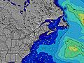 | 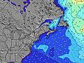 | 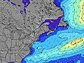 | 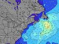 | 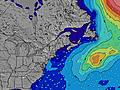 | 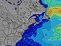 | 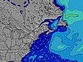 | ||||||||||||||
Wave Height (m) Direction Period (s) | SE 9 | SSE 5 | SSE 5 | SSE 5 | SSE 7 | SSE 8 | SSE 8 | SE 7 | SSE 7 | SE 7 | SE 7 | SSE 5 | SSE 6 | SSE 4 | SSE 6 | SSE 6 | SSE 3 | SSE 5 | SE 8 | SE 8 | SSE 6 |
Wave Graph | |||||||||||||||||||||
12 | 95 | 35 | 58 | 301 | 170 | 43 | 23 | 31 | 23 | 11 | 36 | 30 | 24 | 92 | 25 | 8 | 15 | 9 | 9 | 64 | |
Wind (km/h) | |||||||||||||||||||||
Wind State on-shore cross-onshore cross-shore cross-offshore off-shore glassy | cross | cross | cross | cross-off | cross-off | off | off | off | off | cross | cross | cross-off | cross-off | cross-off | cross-off | off | off | cross-off | cross-on | cross-on | cross-off |
High Tide | 2:28PM3.16m | 2:43AM3.13m | 3:08PM3.18m | 3:28AM3.04m | 3:51PM3.20m | 4:18AM2.95m | 4:41PM3.21m | 5:14AM2.87m | 5:36PM3.23m | 6:17AM2.83m | 6:38PM3.28m | 7:23AM2.86m | 7:43PM3.37m | ||||||||
Low Tide | 8:16AM0.55m | 8:36PM0.67m | 8:54AM0.61m | 9:21PM0.67m | 9:35AM0.68m | 10:10PM0.67m | 10:22AM0.75m | 11:05PM0.67m | 11:15AM0.81m | 00:06AM0.64m | 12:16PM0.84m | 1:11AM0.58m | 1:21PM0.81m | 2:17AM0.46m | |||||||
5:33 | — | — | 5:35 | — | — | 5:35 | — | — | 5:37 | — | — | 5:37 | — | — | 5:39 | — | — | 5:41 | — | — | |
— | 8:02 | — | — | 8:01 | — | — | 8:00 | — | — | 7:59 | — | — | 7:58 | — | — | 7:57 | — | — | 7:54 | — | |
mm | — | — | 5 | 5 | 5 | — | — | — | — | — | 4 | 3 | — | — | — | — | — | — | — | — | 1 |
Temp °C | 25 | 28 | 24 | 23 | 23 | 23 | 26 | 31 | 28 | 26 | 21 | 23 | 27 | 32 | 30 | 30 | 34 | 30 | 25 | 28 | 27 |
Feels °C | 25 | 27 | 24 | 23 | 22 | 23 | 24 | 28 | 27 | 23 | 22 | 24 | 29 | 33 | 32 | 30 | 32 | 29 | 25 | 28 | 30 |
Swell 1 Height (m) Direction Period (s) | SE 7 | — | ESE 9 | SE 9 | — | SSE 8 | SSE 8 | SE 7 | SSE 7 | SE 7 | SE 7 | SSE 5 | SSE 6 | ESE 8 | E 9 | SSE 6 | E 9 | SSE 5 | SSE 5 | SE 8 | SSE 6 |
8 | — | 7 | 3 | — | 170 | 43 | 23 | 31 | 23 | 11 | 36 | 30 | 6 | 2 | 25 | 2 | 15 | 6 | 9 | 64 | |
Swell 2 Height (m) Direction Period (s) | SE 9 | — | — | E 8 | — | — | — | SSE 8 | E 10 | E 10 | E 9 | SE 8 | E 9 | E 9 | — | — | E 9 | SE 8 | SE 8 | E 8 | E 8 |
12 | — | — | 1 | — | — | — | 7 | 2 | 2 | 2 | 3 | 2 | 2 | — | — | 2 | 2 | 9 | 1 | 1 | |
Swell 3 Height (m) Direction Period (s) | — | — | — | — | — | — | — | — | E 10 | — | — | E 9 | — | — | — | E 9 | — | E 8 | E 8 | — | — |
— | — | — | — | — | — | — | — | 2 | — | — | 2 | — | — | — | 2 | — | 1 | 1 | — | — | |
Wind waves Height (m) Direction Period (s) | S 4 | SSE 5 | SSE 5 | SSE 5 | SSE 7 | WSW 3 | WNW 3 | — | — | — | SSE 4 | WSW 3 | — | SSE 4 | SSE 6 | WSW 3 | SSE 3 | — | — | SSE 5 | S 6 |
9 | 95 | 35 | 58 | 301 | 4 | 2 | — | — | — | 7 | 1 | — | 24 | 92 | 3 | 8 | — | — | 5 | 106 | |
Nearest Offshore or Glassy | |||||||||||||||||||||
Distance (km) | 618 | 2685 | 1256 | 367 | 385 | 0 | 38 | 38 | 182 | 197 | 197 | 197 | 197 | 197 | 0 | 182 | 1296 | 168 | 384 | 197 | 0 |
Best forecast wave conditions in New Hampshire | |||||||||||||||||||||
Best forecast wave conditions in United States | |||||||||||||||||||||
Header Global | |||||||||||||||||||||
- Map Icons:
 Break
Break Live Wave Height (m)
 Live Wind Speed (km/h)
 Surf Rating (10 Max)
 Ocean Swells (m)
- Wind Speed (km/h)
Latest Updates


FREE! Surf-Forecast.com widget for your website
The surf report / weather widget below is available to embed on third party websites free of charge and provides a summary of our Plaice Cove surf forecast. Simply grab the html code snippet that we provide and paste it into your own site. You can choose your preferred language and metric/imperial units for the surf forecast feed to suit users of your site. Click here to get the code.
Information about the Plaice Cove Surf forecast
The above surf forecast table for Plaice Cove provides essential information for determining whether the surfing conditions will be good over the next 16 days. A general guide to surfing at Plaice Cove can be found by selecting the local surf guide option on the grey menu. Our Plaice Cove surf forecast is unique since it includes wave energy (power) that defines the real feel of the surf rather than just the height or the period. If you surf the same spot (Plaice Cove) regularly then make a mental note of the wave energy from the surf forecast table each time you go. Very soon you may start to choose your surf days based on the wave energy alone combined with our forecast of favourable offshore wind conditions. Our star ratings will help here and of course you will also find the usual wave height and period predictions on our surf forecasts as well as a full break down of the swell components under our advanced users option (to reveal that, click the little Einstein character under the tide times).
Further information to help with frequently asked questions about our surf forecast for Plaice Cove may be found under the help tab on the top menu and also by moving your mouse over the question marks on the surf forecast table itself. Please always bear in mind that the forecast is for near-shore open water and local factors at each surf break influence the actual breaking wave height, such as the beach / reef profile, water depths offshore and shelter.
Plaice Cove is 4 km (2 miles) from Hampton. If you plan a vacation in New Hampshire, look for hotels and other accommodation in Hampton. Hampton has rooms for a wide range of budgets as well as car hire and transport links.
 Nearest