

Surf Forecasts:

Bonnet Point surf forecast from 14 Jul 2026:
- Best quality surf: Sunday 19 Jul, 11PM (local time) - 4.5ft (1.4m), 8s period, S swell with cross-offshore winds.
- Most powerful swell: Sunday 19 Jul, 11PM (local time) - 4.5ft (1.4m), 8s period, S swell with 260 kJ wave energy.
- Next surfable swell (1★+): Sunday 19 Jul, 11PM (local time) - 4.5ft (1.4m), 8s period with S swell.
Best Forecast Surf Conditions for Bonnet Point this week:
The surf forecast for Bonnet Point over the next 16 days: The first swell (rated 1 star or higher) is forecast to arrive on Sunday (Jul 19) at 11PM. The primary swell is predicted to be 1.4m and 8s period. The wind is predicted to be cross-offshore as the swell arrives.
The most powerful waves expected at Bonnet Point in the next 16 days are 1.4m 8s and forecast to arrive on Sunday (Jul 19) at 11PM. Winds are predicted to be cross-offshore at the time the swell arrives. The largest open ocean swell (not directed at the beach) is 0.4m 4s period and expected on Thursday (Jul 16) at 8PM.
| Wave Type | Time (EDT) & Date | Wave Height & Period |
|---|---|---|
| Next good surf (1 star+) | 11PM (Sun 19th Jul) | 4.5ft (1.4m) 8s |
| Best Surf | 11PM (Sun 19th Jul) | 4.5ft (1.4m) 8s |
| Most Powerful | 11PM (Sun 19th Jul) | 4.5ft (1.4m) 8s |
Table - best surf conditions forecast for Bonnet Point over the next 16 days.
The Lowdown
Hey, Rusty here. Gotta be straight – the next 16 days at Bonnet Point look flat and crappy. This point’s always inconsistent, and this forecast delivers nothing good for a long stretch. From Tuesday the 14th through to the morning of Monday the 20th, it’s all poor surf – choppy, cross‑onshore wind, tiny swell with weak energy. A full week of nothing.
Then Monday morning the 20th shows a little pulse: about 3ft of S swell, 9‑second period, offshore WNW breeze at 3 mph, clean. Combined energy moderate at 164. It’s only a 1 out of 10 on the surfable-but-ordinary scale, so don’t get hyped. Crowds are possible now and then, but this won’t draw anyone. That afternoon the wind turns and it’s poor again.
Next morning, Tuesday the 21st, another tiny window: 3ft S swell, 8 seconds, clean offshore ENE breeze at 3 mph. Weak energy at 89. Still just ordinary. After that, it’s onshore winds, short‑period junk, and poor conditions all the way to the end. There’s a day on Wednesday the 29th with 5ft swell and energy hitting 462, but it’s blowing 19 mph onshore – that’s kite‑surfing territory, not paddle surf.
So bottom line: if you really need a paddle, try the morning of July 20. Otherwise, wait for a better forecast. Things can change, but right now Bonnet Point is a dud.
Rusty.
Short Range ForecastSome drizzle, heaviest during Wed afternoon. Warm (max 33°C on Wed afternoon, min 21°C on Mon night). Winds decreasing (fresh winds from the SW on Tue afternoon, light winds from the NW by Wed night). | Days 5-7 Weather SummaryHeavy rain (total 29mm), heaviest during Sat night. Warm (max 29°C on Sun afternoon, min 19°C on Thu night). Winds increasing (calm on Thu night, fresh winds from the SW by Sat night). | ||||||||||||||||||||
Tuesday 14 | Wednesday 15 | Thursday 16 | Friday 17 | Saturday 18 | Sunday 19 | Mon 20 | |||||||||||||||
Night | AM | PM | Night | AM | PM | Night | AM | PM | Night | AM | PM | Night | AM | PM | Night | AM | PM | Night | AM | PM | |
Swell Height Map |  |  |  |  | 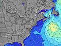 | 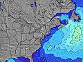 | 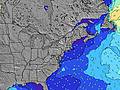 | 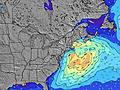 | |||||||||||||
Wave Height (m) Direction Period (s) | SSW 4 | SSW 5 | SSW 6 | SSW 7 | SSW 7 | SW 6 | SSW 6 | S 6 | SSW 5 | S 6 | SSW 6 | SSW 6 | SSW 6 | SSW 6 | S 3 | SSE 5 | SSW 6 | SSW 6 | S 9 | S 9 | S 9 |
Wave Graph | |||||||||||||||||||||
23 | 36 | 82 | 230 | 47 | 128 | 21 | 21 | 20 | 17 | 10 | 21 | 12 | 6 | 6 | 64 | 144 | 125 | 258 | 164 | 198 | |
Wind (km/h) | |||||||||||||||||||||
Wind State on-shore cross-onshore cross-shore cross-offshore off-shore glassy | cross-on | cross-on | cross-on | cross-on | cross-off | cross | cross-off | cross | cross-on | cross | cross-off | cross | cross | cross-on | on | cross-on | cross | cross-off | cross-off | cross-off | cross-off |
High Tide | 8:13AM1.20m | 8:40PM1.41m | 9:06AM1.26m | 9:31PM1.39m | 9:58AM1.28m | 10:22PM1.33m | 10:50AM1.28m | 11:12PM1.24m | 11:43AM1.25m | 00:03AM1.14m | 12:35PM1.21m | 00:53AM1.04m | 1:26PM1.15m | ||||||||
Low Tide | 2:28AM-0.02m | 1:54PM-0.07m | 3:18AM-0.04m | 2:52PM-0.06m | 4:03AM-0.04m | 3:48PM-0.03m | 4:42AM-0.02m | 4:40PM0.02m | 5:18AM0.01m | 5:31PM0.09m | 5:54AM0.05m | 6:25PM0.17m | 6:32AM0.11m | 7:27PM0.23m | |||||||
— | 5:22 | — | — | 5:24 | — | — | 5:24 | — | — | 5:26 | — | — | 5:26 | — | — | 5:28 | — | — | 5:28 | — | |
8:19 | — | 8:17 | — | — | 8:17 | — | — | 8:16 | — | — | 8:15 | — | — | 8:15 | — | — | 8:15 | — | — | 8:14 | |
mm | — | — | — | — | — | 1 | — | — | — | — | — | — | — | — | 3 | 26 | — | — | — | — | — |
Temp °C | 21 | 26 | 28 | 24 | 31 | 33 | 29 | 29 | 28 | 27 | 26 | 28 | 26 | 24 | 21 | 22 | 27 | 29 | 25 | 23 | 26 |
Feels °C | 19 | 24 | 25 | 22 | 31 | 33 | 29 | 27 | 25 | 26 | 25 | 25 | 24 | 24 | 21 | 22 | 25 | 26 | 23 | 21 | 22 |
Swell 1 Height (m) Direction Period (s) | SE 9 | SE 9 | SE 9 | SSW 7 | SSW 7 | SSW 6 | SSW 6 | S 6 | S 8 | S 6 | SSW 6 | SSW 6 | SSW 6 | SSW 6 | S 13 | — | S 13 | S 13 | S 9 | S 9 | S 9 |
3 | 3 | 3 | 140 | 47 | 42 | 21 | 21 | 1 | 17 | 10 | 10 | 12 | 6 | 3 | — | 3 | 3 | 258 | 164 | 198 | |
Swell 2 Height (m) Direction Period (s) | — | — | — | — | SE 9 | S 9 | S 9 | S 9 | — | S 9 | S 9 | S 8 | S 14 | S 14 | S 8 | — | — | — | — | NNW 3 | — |
— | — | — | — | 3 | 2 | 1 | 1 | — | 2 | 2 | 1 | 4 | 4 | 1 | — | — | — | — | 2 | — | |
Swell 3 Height (m) Direction Period (s) | — | — | — | — | — | — | S 17 | — | — | S 15 | S 15 | S 14 | S 8 | S 8 | — | — | — | — | — | — | — |
— | — | — | — | — | — | 5 | — | — | 5 | 4 | 4 | 1 | 1 | — | — | — | — | — | — | — | |
Wind waves Height (m) Direction Period (s) | SSW 4 | SSW 5 | SSW 6 | SSW 7 | — | SW 6 | — | — | SSW 5 | — | — | SSW 6 | — | — | S 3 | SSE 5 | SSW 6 | SSW 6 | WNW 3 | — | — |
23 | 36 | 82 | 230 | — | 128 | — | — | 20 | — | — | 21 | — | — | 6 | 64 | 144 | 125 | 3 | — | — | |
Nearest Offshore or Glassy | |||||||||||||||||||||
Distance (km) | 885 | 518 | 1229 | 165 | 9 | 4 | 81 | 57 | 57 | 57 | 612 | 615 | 35 | 604 | 2941 | 432 | 165 | 1 | 0 | 0 | 1 |
Best forecast wave conditions in Rhode Island | |||||||||||||||||||||
Best forecast wave conditions in United States | |||||||||||||||||||||
Header Global | |||||||||||||||||||||
- Map Icons:
 Break
Break Live Wave Height (m)
 Live Wind Speed (km/h)
 Surf Rating (10 Max)
 Ocean Swells (m)
- Wind Speed (km/h)


FREE! Surf-Forecast.com widget for your website
The surf report / weather widget below is available to embed on third party websites free of charge and provides a summary of our Bonnet Point surf forecast. Simply grab the html code snippet that we provide and paste it into your own site. You can choose your preferred language and metric/imperial units for the surf forecast feed to suit users of your site. Click here to get the code.
Information about the Bonnet Point Surf forecast
The above surf forecast table for Bonnet Point provides essential information for determining whether the surfing conditions will be good over the next 16 days. A general guide to surfing at Bonnet Point can be found by selecting the local surf guide option on the grey menu. Our Bonnet Point surf forecast is unique since it includes wave energy (power) that defines the real feel of the surf rather than just the height or the period. If you surf the same spot (Bonnet Point) regularly then make a mental note of the wave energy from the surf forecast table each time you go. Very soon you may start to choose your surf days based on the wave energy alone combined with our forecast of favourable offshore wind conditions. Our star ratings will help here and of course you will also find the usual wave height and period predictions on our surf forecasts as well as a full break down of the swell components under our advanced users option (to reveal that, click the little Einstein character under the tide times).
Further information to help with frequently asked questions about our surf forecast for Bonnet Point may be found under the help tab on the top menu and also by moving your mouse over the question marks on the surf forecast table itself. Please always bear in mind that the forecast is for near-shore open water and local factors at each surf break influence the actual breaking wave height, such as the beach / reef profile, water depths offshore and shelter.
Bonnet Point is 5 km (3 miles) from Narragansett Pier. If you plan a vacation in Rhode Island, look for hotels and other accommodation in Narragansett Pier. Narragansett Pier has rooms for a wide range of budgets as well as car hire and transport links.
 Nearest