

Surf Forecasts:

Aiguadolc surf forecast from 3 Jul 2026:
- Most powerful swell: Wednesday 8 Jul, 8AM (local time) - 2ft (0.6m), 5s period, SSW swell with 17 kJ wave energy.
Best Forecast Surf Conditions for Aiguadolc this week:
The most powerful waves expected at Aiguadolc in the next 16 days are 0.6m 5s and forecast to arrive on Wednesday (Jul 08) at 8AM. Winds are predicted to be cross-offshore at the time the swell arrives. The largest open ocean swell (not directed at the beach) is 0.1m 4s period and expected on Saturday (Jul 04) at 5AM.
| Wave Type | Time (CEST) & Date | Wave Height & Period |
|---|---|---|
| Next good surf (1 star+) | - | - |
| Best Surf | - | - |
| Most Powerful | 8AM (Wed 8th Jul) | 2ft (0.6m) 5s |
Table - best surf conditions forecast for Aiguadolc over the next 16 days.
Updates in hr min s Forecast update imminent
Right then, let’s have a look what we’ve got for our local stretch here at Aiguadolc.
To be straight with you, the next sixteen days are looking flat. Proper flat. There’s nothing happening right now and it’s going to stay that way for a long, long stretch. We’ve got a big run of zero swell days coming – you’re looking at basically dead calm through the weekend and into next week. Don’t even bother checking the forecast; it’s a total write-off for any kind of wave.
The only whisper of any energy shows up around Tuesday the 8th of July morning, with a tiny 2 ft swell from the SSW at a short 5 second period. The combined energy is still super weak at just 24, and the wind is light cross-off from the NW, so the water will be clean. But honestly, 2 ft and 5 seconds is barely a ripple. It’s not worth paddling out for. By the 12th of July, Sunday morning, we get a little 2 ft swell from the east at 5 seconds with a clean offshore breeze from the NNE and a combined energy reading of 34 – again, nothing to get excited about. That’s as good as it gets, and it’s still poor.
Water temps are a talking point though. On Friday the 3rd, the water was sitting at a very warm 80°, which is much warmer than normal for this time of year – over 5° above average. That’s unusual. But there’s no surf to enjoy it in.
Bottom line: there are no decent waves on the cards. This stretch of coastline is just not firing. For a break that’s already inconsistent, this blank run is more normal for the area. Forecasts can change, but for now, leave the boards in the shed.
Rusty.
Short Range ForecastMostly dry. Warm (max 31°C on Sun morning, min 26°C on Fri night). Wind will be generally light. | Days 5-7 Weather SummaryMostly dry. Warm (max 32°C on Wed morning, min 26°C on Mon night). Wind will be generally light. | ||||||||||||||||||||
Fri 3 | Saturday 4 | Sunday 5 | Monday 6 | Tuesday 7 | Wednesday 8 | Thursday 9 | |||||||||||||||
PM | Night | AM | PM | Night | AM | PM | Night | AM | PM | Night | AM | PM | Night | AM | PM | Night | AM | PM | Night | AM | |
Swell Height Map | 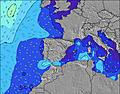 |  |  |  |  |  |  | 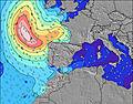 | |||||||||||||
Wave Height (m) Direction Period (s) | ENE 8 | SW 4 | — | SW 5 | SSW 4 | — | SSW 3 | SSW 4 | — | SSW 3 | SSW 4 | SSW 4 | SSW 5 | SSW 4 | SSW 5 | SSW 5 | S 4 | S 4 | S 4 | S 3 | — |
Wave Graph | |||||||||||||||||||||
6 | 4 | 0 | 0 | 1 | 0 | 1 | 1 | 0 | 1 | 1 | 2 | 9 | 3 | 17 | 8 | 1 | 1 | 1 | 1 | 0 | |
Wind (km/h) | |||||||||||||||||||||
Wind State on-shore cross-onshore cross-shore cross-offshore off-shore glassy | on | cross-off | glassy | on | cross-off | glassy | on | cross-off | glassy | on | cross-off | cross-off | cross-on | cross-on | cross-off | cross-on | cross | cross-off | cross-on | glassy | cross-off |
High Tide | 00:25AM0.20m | 11:06AM0.09m | 00:56AM0.19m | 12:07PM0.09m | 1:26AM0.18m | 1:24PM0.09m | 1:57AM0.17m | 2:54PM0.10m | 2:32AM0.16m | 4:27PM0.12m | 3:16AM0.14m | 5:47PM0.14m | |||||||||
Low Tide | 4:38PM0.02m | 7:41AM0.08m | 5:13PM0.02m | 8:12AM0.07m | 5:51PM0.04m | 8:43AM0.06m | 6:36PM0.06m | 9:16AM0.06m | 7:40PM0.07m | 9:51AM0.05m | 9:16PM0.09m | 10:32AM0.04m | 11:19PM0.10m | ||||||||
— | — | 6:24 | — | — | 6:24 | — | — | 6:24 | — | — | 6:26 | — | — | 6:26 | — | — | 6:26 | — | — | 6:28 | |
— | 9:29 | — | — | 9:29 | — | — | 9:28 | — | — | 9:28 | — | — | 9:28 | — | — | 9:27 | — | — | 9:27 | 9:27 | |
mm | — | — | — | — | — | — | — | — | — | — | — | — | — | — | — | — | — | — | — | — | — |
Temp °C | 29 | 27 | 29 | 28 | 28 | 31 | 31 | 29 | 30 | 29 | 28 | 29 | 29 | 28 | 32 | 32 | 29 | 30 | 31 | 29 | 30 |
Feels °C | 26 | 28 | 28 | 27 | 28 | 30 | 29 | 28 | 29 | 28 | 29 | 29 | 29 | 30 | 31 | 32 | 31 | 30 | 30 | 31 | 29 |
Swell 1 Height (m) Direction Period (s) | ENE 8 | E 4 | — | — | SSW 4 | — | — | SSW 4 | — | — | SSW 4 | SSW 4 | SSW 5 | SSW 4 | SSW 4 | SSW 5 | S 4 | S 4 | S 4 | S 3 | — |
6 | 2 | — | — | 1 | — | — | 1 | — | — | 1 | 2 | 9 | 3 | 7 | 8 | 1 | 1 | 1 | 1 | — | |
Swell 2 Height (m) Direction Period (s) | WSW 4 | SSW 4 | — | SW 5 | — | — | — | E 5 | — | — | E 6 | SW 5 | — | — | — | — | — | — | — | — | — |
1 | 1 | — | 1 | — | — | — | 1 | — | — | 1 | 1 | — | — | — | — | — | — | — | — | — | |
Swell 3 Height (m) Direction Period (s) | — | — | — | — | — | — | — | — | — | — | — | — | — | — | — | — | — | — | — | — | — |
— | — | — | — | — | — | — | — | — | — | — | — | — | — | — | — | — | — | — | — | — | |
Wind waves Height (m) Direction Period (s) | SW 4 | SW 4 | — | — | — | — | SSW 3 | — | — | SSW 3 | — | — | — | — | SSW 5 | — | — | — | — | — | — |
1 | 4 | — | — | — | — | 1 | — | — | 1 | — | — | — | — | 17 | — | — | — | — | — | — | |
Nearest Offshore or Glassy | |||||||||||||||||||||
Distance (km) | 385 | 239 | 147 | 444 | 379 | 374 | 444 | 384 | 373 | 563 | 199 | 373 | 640 | 477 | 393 | 441 | 384 | 390 | 835 | 384 | 733 |
Best forecast wave conditions in Catalunia | |||||||||||||||||||||
Best forecast wave conditions in Spain (Europe) | |||||||||||||||||||||
Header Global | |||||||||||||||||||||
- Map Icons:
 Break
Break Live Wave Height (m)
 Live Wind Speed (km/h)
 Surf Rating (10 Max)
 Ocean Swells (m)
- Wind Speed (km/h)


FREE! Surf-Forecast.com widget for your website
The surf report / weather widget below is available to embed on third party websites free of charge and provides a summary of our Aiguadolc surf forecast. Simply grab the html code snippet that we provide and paste it into your own site. You can choose your preferred language and metric/imperial units for the surf forecast feed to suit users of your site. Click here to get the code.
Information about the Aiguadolc Surf forecast
The above surf forecast table for Aiguadolc provides essential information for determining whether the surfing conditions will be good over the next 16 days. A general guide to surfing at Aiguadolc can be found by selecting the local surf guide option on the grey menu. Our Aiguadolc surf forecast is unique since it includes wave energy (power) that defines the real feel of the surf rather than just the height or the period. If you surf the same spot (Aiguadolc) regularly then make a mental note of the wave energy from the surf forecast table each time you go. Very soon you may start to choose your surf days based on the wave energy alone combined with our forecast of favourable offshore wind conditions. Our star ratings will help here and of course you will also find the usual wave height and period predictions on our surf forecasts as well as a full break down of the swell components under our advanced users option (to reveal that, click the little Einstein character under the tide times).
Further information to help with frequently asked questions about our surf forecast for Aiguadolc may be found under the help tab on the top menu and also by moving your mouse over the question marks on the surf forecast table itself. Please always bear in mind that the forecast is for near-shore open water and local factors at each surf break influence the actual breaking wave height, such as the beach / reef profile, water depths offshore and shelter.
Aiguadolc is 1 km (1 miles) from Sitges. If you plan a holiday in Catalunia, look for hotels and other accommodation in Sitges. Sitges has rooms for a wide range of budgets as well as car hire and transport links.
 Nearest