
Surf Forecasts:

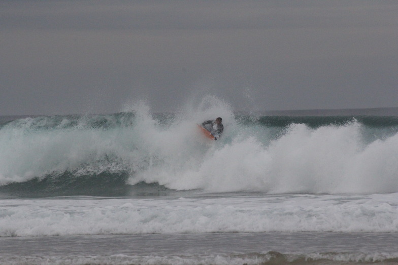
Playa de Baldayo - La Laguna surf forecast from 22 Jul 2026:
- Best quality surf: Wednesday 22 Jul, 8AM (local time) - 5ft (1.5m), 7s period, NNE swell with offshore winds.
- Most powerful swell: Monday 27 Jul, 2AM (local time) - 5ft (1.6m), 10s period, NNW swell with 521 kJ wave energy.
- Next surfable swell (1★+): Wednesday 22 Jul, 8AM (local time) - 5ft (1.5m), 7s period with NNE swell.
Best Forecast Surf Conditions for Playa de Baldayo - La Laguna this week:
The surf forecast for Playa de Baldayo - La Laguna over the next 16 days: The first swell (rated 1 star or higher) is forecast to arrive on Wednesday (Jul 22) at 8AM. The primary swell is predicted to be 1.5m and 7s period with a secondary swell of 0.3m and 10s. The wind is predicted to be offshore as the swell arrives.
The most powerful waves expected at Playa de Baldayo - La Laguna in the next 16 days are 1.6m 10s and forecast to arrive on Monday (Jul 27) at 2AM. Winds are predicted to be cross-onshore at the time the swell arrives. The largest open ocean swell (not directed at the beach) is 0.4m 3s period and expected on Saturday (Jul 25) at 5AM.
| Wave Type | Time (CEST) & Date | Wave Height & Period |
|---|---|---|
| Next good surf (1 star+) | 8AM (Wed 22nd Jul) | 5ft (1.5m) 7s |
| Best Surf | 8AM (Wed 22nd Jul) | 5ft (1.5m) 7s |
| Most Powerful | 2AM (Mon 27th Jul) | 5ft (1.6m) 10s |
Table - best surf conditions forecast for Playa de Baldayo - La Laguna over the next 16 days.
The Lowdown
Alright folks, Rusty here. Let’s talk about what’s on the menu for Playa de Baldayo – La Laguna.
We’ve got a bit of a mixed bag ahead. The good news is there’s swell on the horizon, but the wind is going to be a real pain for most of the forecast. The real standout is going to be right at the start, so don’t sleep on it.
The best session by far is Wednesday morning, 22 July. The water is sitting at 64°, which is about normal for this time of year. We’re looking at a clean 5ft swell pushing in from the NNE, with a period of 7 seconds. The wind is absolutely glassy – dead calm, zero from the north. That’s going to give you a clean, smooth face. The combined energy is moderate at 247, so there’s enough push behind it. It’s a consistent break, so you’ll be kept busy. Expect some company though, because crowds are possible here.
After that glorious morning, the wind turns onshore and the quality drops right off. Wednesday afternoon is a no-go with onshore wind, and the swell drops a touch to 4ft. Thursday morning, 23 July, we get a little glassy window again, but the swell is way down to 2ft from the north, with only 80 combined energy. It’s surfable, but honestly, it’s pretty ordinary. Thursday afternoon and Friday are poor, with the wind starting to mess things up.
We hit a bit of a dry spell through the weekend. Saturday and Sunday, 25-26 July, have some swell height but the wind is cross-onshore and messy. The combined energy on Saturday afternoon hits 215, but it’s blown out. Not worth paddling out for.
The whole first week of August looks rough. The swell picks up again, but so does the wind. Monday 27 July sees a 5ft swell from the NNW with a 10-second period and a combined energy of 406 – that’s moderate wave energy – but it’s a cross-on mess. The same story repeats all the way through to the end of the forecast. There’s a moment on Saturday morning, 1 August, with a 5ft swell from the WNW and a period of 10 seconds, giving a strong 520 combined energy. The wind is just a light cross-shore, but the forecast says the conditions are only marginal. It’s worth a look if you’re desperate, but it’s not the gem we started with.
For the rest of the run, from 2 August onwards, the swell continues to pump – with readings of 5ft and 6ft and combined energy hitting 823 on Sunday afternoon – but the wind is relentless. It’s a strong cross-onshore, making it choppy and lumpy. For a beginner, anything over 5ft like these swells is too big, and with the wind, it’s really only for the experienced guys who don’t mind a battle.
So, to wrap it up: get out on Wednesday morning, 22 July, for the best you’re going to get. After that, it’s a long wait for anything clean. If you’re looking at the bigger, windier days, it might be more fun for the kite surfers than the paddle crew.
Rusty.
Short Range ForecastMostly dry. Warm (max 24°C on Wed afternoon, min 16°C on Wed morning). Wind will be generally light. | Days 4-6 Weather SummarySome drizzle, heaviest during Sat afternoon. Warm (max 26°C on Mon afternoon, min 16°C on Sat morning). Wind will be generally light. | ||||||||||||||||||||
Wednesday 22 | Thursday 23 | Friday 24 | Saturday 25 | Sunday 26 | Monday 27 | Tuesday 28 | |||||||||||||||
AM | PM | Night | AM | PM | Night | AM | PM | Night | AM | PM | Night | AM | PM | Night | AM | PM | Night | AM | PM | Night | |
Swell Height Map |  |  |  | 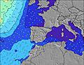 | 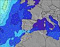 | 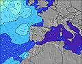 | 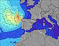 | ||||||||||||||
Wave Height (m) Direction Period (s) | NNE 7 | NNE 7 | NNE 7 | N 7 | N 7 | N 7 | N 7 | N 6 | NNW 7 | NW 7 | NNW 7 | NNW 6 | NNW 6 | N 6 | NNW 10 | NNW 10 | NNW 9 | NW 9 | NW 9 | NW 9 | NW 10 |
Wave Graph | |||||||||||||||||||||
228 | 183 | 154 | 48 | 57 | 70 | 32 | 27 | 15 | 151 | 204 | 121 | 71 | 60 | 521 | 349 | 226 | 190 | 152 | 107 | 208 | |
Wind (km/h) | |||||||||||||||||||||
Wind State on-shore cross-onshore cross-shore cross-offshore off-shore glassy | glassy | on | glassy | glassy | on | off | cross-off | cross | cross-off | cross-on | cross-on | on | glassy | on | cross-on | cross | cross-on | cross-off | cross-on | cross-on | cross-on |
High Tide | 11:14AM2.92m | 11:39PM2.63m | 12:23PM2.84m | 00:49AM2.56m | 1:33PM2.86m | 1:58AM2.59m | 2:35PM2.95m | 2:55AM2.69m | 3:27PM3.08m | 3:41AM2.83m | 4:09PM3.23m | 4:21AM2.98m | 4:47PM3.36m | 4:57AM3.11m | |||||||
Low Tide | 5:27PM1.34m | 5:42AM1.30m | 6:42PM1.43m | 6:53AM1.33m | 7:56PM1.40m | 8:02AM1.27m | 8:56PM1.30m | 8:58AM1.13m | 9:43PM1.17m | 9:45AM0.97m | 10:22PM1.03m | 10:24AM0.81m | 10:57PM0.90m | ||||||||
7:13 | — | — | 7:13 | — | — | 7:15 | — | — | 7:16 | — | — | 7:16 | — | — | 7:18 | — | — | 7:18 | — | — | |
— | — | 10:07 | — | — | 10:06 | — | — | 10:05 | — | — | 10:04 | — | — | 10:02 | — | — | 10:01 | — | — | 10:00 | |
mm | — | — | — | — | — | — | — | — | — | — | 1 | — | — | — | — | — | — | — | — | — | — |
Temp °C | 22 | 24 | 22 | 21 | 23 | 21 | 22 | 24 | 23 | 20 | 22 | 19 | 18 | 21 | 19 | 22 | 26 | 24 | 25 | 26 | 20 |
Feels °C | 23 | 24 | 23 | 22 | 22 | 22 | 22 | 23 | 21 | 20 | 21 | 18 | 19 | 22 | 19 | 21 | 25 | 25 | 26 | 27 | 21 |
Swell 1 Height (m) Direction Period (s) | NNE 7 | NNE 7 | NNE 7 | N 7 | N 7 | N 7 | N 7 | N 6 | NNW 7 | NW 7 | ENE 6 | NNW 6 | NNW 6 | N 6 | NNW 10 | NNW 10 | NNW 9 | NW 9 | NW 9 | NW 9 | NW 10 |
228 | 183 | 154 | 48 | 57 | 70 | 32 | 27 | 15 | 151 | 3 | 121 | 71 | 60 | 521 | 349 | 226 | 190 | 152 | 107 | 208 | |
Swell 2 Height (m) Direction Period (s) | WNW 10 | WNW 9 | W 9 | NE 6 | NE 6 | W 9 | NNE 6 | ENE 6 | NNE 6 | WSW 5 | W 10 | NE 6 | NE 6 | WNW 9 | WNW 9 | WNW 9 | WNW 9 | NE 6 | NE 5 | NNW 11 | WNW 11 |
19 | 17 | 15 | 24 | 13 | 6 | 26 | 3 | 8 | 6 | 8 | 20 | 14 | 27 | 25 | 26 | 26 | 77 | 16 | 51 | 12 | |
Swell 3 Height (m) Direction Period (s) | — | — | NNW 8 | NNE 6 | W 9 | — | W 8 | W 8 | W 8 | NE 6 | — | WNW 10 | WNW 9 | NNW 12 | — | — | — | WNW 8 | N 6 | W 8 | — |
— | — | 6 | 8 | 6 | — | 5 | 5 | 5 | 6 | — | 9 | 27 | 53 | — | — | — | 14 | 17 | 5 | — | |
Wind waves Height (m) Direction Period (s) | — | — | — | — | — | — | — | — | SW 7 | — | NNW 7 | — | — | — | — | NE 5 | NE 6 | — | — | NNE 5 | NNE 5 |
— | — | — | — | — | — | — | — | 7 | — | 204 | — | — | — | — | 31 | 88 | — | — | 38 | 29 | |
Nearest Offshore or Glassy | |||||||||||||||||||||
Distance (km) | 0 | 35 | 0 | 0 | 13 | 0 | 0 | 988 | 61 | 13 | 166 | 63 | 0 | 198 | 63 | 58 | 112 | 0 | 35 | 63 | 25 |
Best forecast wave conditions in Galicia | |||||||||||||||||||||
Best forecast wave conditions in Spain (Europe) | |||||||||||||||||||||
Header Global | |||||||||||||||||||||
- Map Icons:
 Break
Break Live Wave Height (m)
 Live Wind Speed (km/h)
 Surf Rating (10 Max)
 Ocean Swells (m)
- Wind Speed (km/h)


FREE! Surf-Forecast.com widget for your website
The surf report / weather widget below is available to embed on third party websites free of charge and provides a summary of our Playa de Baldayo - La Laguna surf forecast. Simply grab the html code snippet that we provide and paste it into your own site. You can choose your preferred language and metric/imperial units for the surf forecast feed to suit users of your site. Click here to get the code.
Information about the Playa de Baldayo - La Laguna Surf forecast
The above surf forecast table for Playa de Baldayo - La Laguna provides essential information for determining whether the surfing conditions will be good over the next 16 days. A general guide to surfing at Playa de Baldayo - La Laguna can be found by selecting the local surf guide option on the grey menu. Our Playa de Baldayo - La Laguna surf forecast is unique since it includes wave energy (power) that defines the real feel of the surf rather than just the height or the period. If you surf the same spot (Playa de Baldayo - La Laguna) regularly then make a mental note of the wave energy from the surf forecast table each time you go. Very soon you may start to choose your surf days based on the wave energy alone combined with our forecast of favourable offshore wind conditions. Our star ratings will help here and of course you will also find the usual wave height and period predictions on our surf forecasts as well as a full break down of the swell components under our advanced users option (to reveal that, click the little Einstein character under the tide times).
Further information to help with frequently asked questions about our surf forecast for Playa de Baldayo - La Laguna may be found under the help tab on the top menu and also by moving your mouse over the question marks on the surf forecast table itself. Please always bear in mind that the forecast is for near-shore open water and local factors at each surf break influence the actual breaking wave height, such as the beach / reef profile, water depths offshore and shelter.
Playa de Baldayo - La Laguna is 10 km (6 miles) from Carballo. If you plan a holiday in Galicia, look for hotels and other accommodation in Carballo. Carballo has rooms for a wide range of budgets as well as car hire and transport links.
 Nearest