

Surf Forecasts:

Shooting Gallery surf forecast from 2 Aug 2026:
- Most powerful swell: Saturday 8 Aug, 1AM (local time) - 4.5ft (1.4m), 9s period, N swell with 299 kJ wave energy.
Best Forecast Surf Conditions for Shooting Gallery this week:
The most powerful waves expected at Shooting Gallery in the next 16 days are 1.4m 9s and forecast to arrive on Saturday (Aug 08) at 1AM. Winds are predicted to be cross-onshore at the time the swell arrives.
| Wave Type | Time (WEST) & Date | Wave Height & Period |
|---|---|---|
| Next good surf (1 star+) | - | - |
| Best Surf | - | - |
| Most Powerful | 1AM (Sat 8th Aug) | 4.5ft (1.4m) 9s |
Table - best surf conditions forecast for Shooting Gallery over the next 16 days.
The Lowdown
Alright folks, Rusty here. Let’s get straight into it. We’ve got a 16-day outlook for Shooting Gallery, and honestly, it’s a tough one. The whole period is a write-off for decent surfing. There’s a long dry spell of no good waves on offer right from the start, and it just doesn’t let up.
The forecast is a grim run of constant cross-onshore winds, mostly from the north, with a moderate to fresh breeze that’s just chopping everything up. The swell sticks around a modest 3 ft to 6 ft, but it’s short-period, messy windswell, not the kind of energy that lines up. The combined swell energy peaks at 596 (moderate) on the 15th of August, but it’s paired with a fresh breeze and lumpy conditions, so it’s all for nothing.
The water temperature is sitting at 73°F, which is about 1°F warmer than average for this time of year – nothing unusual, just a touch warm.
The best you can say is that the swell size never gets out of hand, but the wind is just relentless. It’s a classic case of the barometer being stuck on poor. There’s no standout, no hidden gem to chase. Nothing but crossed-up, choppy water.
If you’re a kite surfer, the setup might look interesting with those consistent onshore winds on the 5th and 12th of August, but for paddle surfing, it’s a total blank. Sometimes that’s just how it goes in this neck of the woods.
Stay patient, keep an eye on the charts, but for now, we’re on the beach.
Rusty.
Short Range ForecastMostly dry. Warm (max 25°C on Sun afternoon, min 21°C on Mon night). Wind will be generally light. | Days 5-7 Weather SummaryMostly dry. Warm (max 24°C on Wed afternoon, min 20°C on Thu night). Mainly fresh winds. | |||||||||||||||||||
Sun 2 | Monday 3 | Tuesday 4 | Wednesday 5 | Thursday 6 | Friday 7 | Saturday 8 | ||||||||||||||
PM | Night | AM | PM | Night | AM | PM | Night | AM | PM | Night | AM | PM | Night | AM | PM | Night | AM | PM | Night | |
Swell Height Map |  |  |  | 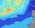 | 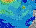 | 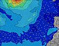 | 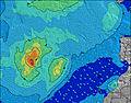 | |||||||||||||
Wave Height (m) Direction Period (s) | N 6 | N 6 | N 6 | N 6 | N 6 | N 6 | N 7 | NNE 6 | NNE 6 | N 6 | N 6 | NNE 6 | N 6 | N 6 | N 6 | N 8 | N 9 | N 9 | N 8 | N 8 |
Wave Graph | ||||||||||||||||||||
62 | 86 | 75 | 59 | 69 | 67 | 69 | 69 | 125 | 83 | 78 | 142 | 99 | 86 | 123 | 241 | 299 | 292 | 266 | 212 | |
Wind (km/h) | ||||||||||||||||||||
Wind State on-shore cross-onshore cross-shore cross-offshore off-shore glassy | cross-on | on | cross-on | cross-on | on | cross-on | cross-on | cross-on | on | on | cross-on | cross-on | cross-on | cross-on | cross-on | cross-on | cross-on | cross-on | cross-on | cross-on |
High Tide | 4:37PM2.33m | 5:00AM2.11m | 5:13PM2.24m | 5:39AM2.04m | 5:54PM2.12m | 6:25AM1.95m | 6:46PM1.97m | 7:24AM1.86m | 7:54PM1.84m | 8:41AM1.80m | 9:24PM1.77m | 10:10AM1.85m | 10:54PM1.83m | |||||||
Low Tide | 10:49PM0.24m | 10:56AM0.35m | 11:26PM0.31m | 11:36AM0.44m | 00:08AM0.42m | 12:26PM0.55m | 1:00AM0.54m | 1:30PM0.65m | 2:11AM0.65m | 2:57PM0.70m | 3:40AM0.68m | 4:33PM0.62m | ||||||||
— | — | 7:16 | — | — | 7:18 | — | — | 7:18 | — | — | 7:18 | — | — | 7:18 | — | — | 7:20 | — | — | |
8:45 | — | — | 8:45 | — | — | 8:44 | — | — | 8:44 | — | — | 8:43 | — | — | 8:42 | — | — | 8:40 | — | |
mm | — | — | — | — | — | — | — | — | — | — | — | — | — | — | — | — | — | — | — | — |
Temp °C | 25 | 23 | 24 | 25 | 22 | 25 | 25 | 22 | 23 | 24 | 22 | 22 | 22 | 21 | 22 | 23 | 21 | 23 | 23 | 21 |
Feels °C | 23 | 22 | 23 | 23 | 22 | 24 | 24 | 21 | 22 | 23 | 21 | 21 | 20 | 20 | 20 | 22 | 20 | 21 | 21 | 20 |
Swell 1 Height (m) Direction Period (s) | WNW 8 | N 6 | WNW 9 | WNW 9 | WNW 9 | ENE 7 | ENE 7 | WNW 8 | NW 8 | ENE 8 | ENE 8 | N 10 | NE 8 | N 9 | N 9 | WNW 9 | WNW 9 | WNW 9 | NW 8 | NW 8 |
47 | 86 | 55 | 32 | 34 | 27 | 37 | 47 | 16 | 55 | 40 | 52 | 64 | 60 | 81 | 32 | 31 | 30 | 18 | 17 | |
Swell 2 Height (m) Direction Period (s) | N 11 | WNW 10 | NE 7 | ENE 8 | N 9 | WNW 9 | NW 9 | N 8 | NW 10 | WNW 11 | WNW 10 | WNW 10 | N 10 | ENE 8 | WNW 9 | NW 9 | NE 8 | WNW 9 | WNW 9 | N 12 |
9 | 61 | 14 | 22 | 13 | 32 | 37 | 5 | 26 | 75 | 67 | 55 | 68 | 39 | 32 | 3 | 11 | 15 | 15 | 11 | |
Swell 3 Height (m) Direction Period (s) | N 9 | N 10 | N 9 | N 9 | — | N 8 | WNW 11 | — | N 11 | N 11 | NNW 11 | — | WNW 10 | WNW 9 | — | N 10 | N 9 | — | — | N 8 |
6 | 17 | 14 | 14 | — | 6 | 12 | — | 2 | 2 | 42 | — | 37 | 34 | — | 2 | 6 | — | — | 1 | |
Wind waves Height (m) Direction Period (s) | N 6 | NE 7 | N 6 | N 6 | N 6 | N 6 | N 7 | NNE 6 | NNE 6 | N 6 | N 6 | NNE 6 | N 6 | N 6 | N 6 | N 8 | N 9 | N 9 | N 8 | N 8 |
62 | 73 | 75 | 59 | 69 | 67 | 69 | 69 | 125 | 83 | 78 | 142 | 99 | 86 | 123 | 241 | 299 | 292 | 266 | 212 | |
Nearest Offshore or Glassy | ||||||||||||||||||||
Distance (km) | 13 | 13 | 13 | 284 | 13 | 222 | 13 | 222 | 222 | 289 | 222 | 222 | 222 | 222 | 222 | 182 | 438 | 439 | 222 | 295 |
Best forecast wave conditions in Fuerteventura | ||||||||||||||||||||
Best forecast wave conditions in Spain (Africa) | ||||||||||||||||||||
Header Global | ||||||||||||||||||||
- Map Icons:
 Break
Break Live Wave Height (m)
 Live Wind Speed (km/h)
 Surf Rating (10 Max)
 Ocean Swells (m)
- Wind Speed (km/h)
Latest Updates


FREE! Surf-Forecast.com widget for your website
The surf report / weather widget below is available to embed on third party websites free of charge and provides a summary of our Shooting Gallery surf forecast. Simply grab the html code snippet that we provide and paste it into your own site. You can choose your preferred language and metric/imperial units for the surf forecast feed to suit users of your site. Click here to get the code.
Information about the Shooting Gallery Surf forecast
The above surf forecast table for Shooting Gallery provides essential information for determining whether the surfing conditions will be good over the next 16 days. A general guide to surfing at Shooting Gallery can be found by selecting the local surf guide option on the grey menu. Our Shooting Gallery surf forecast is unique since it includes wave energy (power) that defines the real feel of the surf rather than just the height or the period. If you surf the same spot (Shooting Gallery) regularly then make a mental note of the wave energy from the surf forecast table each time you go. Very soon you may start to choose your surf days based on the wave energy alone combined with our forecast of favourable offshore wind conditions. Our star ratings will help here and of course you will also find the usual wave height and period predictions on our surf forecasts as well as a full break down of the swell components under our advanced users option (to reveal that, click the little Einstein character under the tide times).
Further information to help with frequently asked questions about our surf forecast for Shooting Gallery may be found under the help tab on the top menu and also by moving your mouse over the question marks on the surf forecast table itself. Please always bear in mind that the forecast is for near-shore open water and local factors at each surf break influence the actual breaking wave height, such as the beach / reef profile, water depths offshore and shelter.
Are you planning a holiday in Fuerteventura? If you are looking for accommodation near Shooting Gallery, camping, hotels and holiday cottages in Fuerteventura, consider staying in La Oliva which is 16 km (10 miles) away. Other places in and around Fuerteventura where you can find information about places to rent, and car hire include Puerto del Rosario which is 28 km (17 miles) away, Puerto del Carmen, Tias and Lanzarote.
 Nearest