

Surf Forecasts:

Arguineguin surf forecast from 3 Aug 2026:
- Most powerful swell: Wednesday 5 Aug, 1PM (local time) - 1ft (0.3m), 13s period, SSW swell with 34 kJ wave energy.
Best Forecast Surf Conditions for Arguineguin this week:
The most powerful waves expected at Arguineguin in the next 16 days are 0.3m 13s and forecast to arrive on Wednesday (Aug 05) at 1PM. Winds are predicted to be cross-offshore at the time the swell arrives. The largest open ocean swell (not directed at the beach) is 1.2m 5s period and expected on Wednesday (Aug 05) at 4AM.
| Wave Type | Time (WEST) & Date | Wave Height & Period |
|---|---|---|
| Next good surf (1 star+) | - | - |
| Best Surf | - | - |
| Most Powerful | 1PM (Wed 5th Aug) | 1ft (0.3m) 13s |
Table - best surf conditions forecast for Arguineguin over the next 16 days.
The Lowdown
Alright folks, Rusty here. Let’s see what we’ve got coming up for the local stretch.
Truth is, the next week and a half is looking pretty flat and lifeless. There’s a long stretch of tiny, weak swell with hardly any energy behind it. The first real sign of something happening doesn’t show up until Thursday the 13th of August, and even then it’s a slow build. From Monday the 3rd right through to Wednesday the 12th, we’re dealing with waves mostly between 0.3 ft and 1.0 ft. The combined energy is in the teens or low double digits, often as low as 5 or 6 (weak energy), so there’s just nothing to work with. Winds are mostly light to moderate from the north or north-northeast, keeping conditions clean, but there’s no push in the water. Even the offshore breezes we get on Monday afternoon the 3rd and Tuesday afternoon the 4th can’t make something out of nothing.
Now, around Thursday the 13th, we start to see a pulse. The swell bumps up to 1.0 ft from the SSW with a very long period of 22 seconds, and the combined energy hits 103 (moderate energy). That’s a groundswell, which can mean better shaped waves, but that period is so long, it might break a bit straight at the beach. The wind is cross-off from the north-northeast at 12 mph, making for clean conditions. By Friday the 14th, the swell holds at 1 ft, still from the SSW, with a period of 19 seconds and energy climbing to 158 (moderate energy). That’s the best we’ve got. Still, the wave height is small, so it’s not going to be a classic.
The standout—and I’m not kidding, it’s the only real option—is Arguineguin on Friday the 14th of August. The swell is 1 ft from the SSW, period of 19 seconds, and combined energy (158) is the highest in the whole outlook. The wind is offshore from the north-northwest at 9 mph on Friday afternoon, which will keep the surface clean. The water temperature is 73°F, which is about average for this time of year. This is a reef break, so it can handle that long-period energy better than a beach break. It’s inconsistent here, and it’s a beginner-friendly spot, so that small size is fine for learners. Crowds are possible sometimes, but with conditions this small, it shouldn’t be too hectic.
The following days, from the 15th, start to back off again. We get a bit of surfable waves on Saturday the 15th, with 1 ft from the SSW and 17-second period, but the energy drops to 120 (moderate energy). Still, it’s ordinary. By Sunday the 16th, the energy is down to 66 (weak energy), and that’s pretty much it. The last few days of the outlook show tiny 1.0 ft waves with periods around 13-14 seconds, and the energy is back in the 30s and 40s. Glassy conditions on the 17th and 18th are nice to look at, but there’s no real ride.
So, there’s a long gap of almost nothing until the 13th, then a brief window of moderate energy at a small size. If you’re keen, Friday the 14th is your day. Otherwise, it’s a waiting game.
Rusty.
Short Range ForecastMostly dry. Warm (max 34°C on Tue morning, min 26°C on Wed night). Wind will be generally light. | Days 4-6 Weather SummaryMostly dry. Warm (max 33°C on Sat afternoon, min 25°C on Sat night). Wind will be generally light. | ||||||||||||||||||||
Monday 3 | Tuesday 4 | Wednesday 5 | Thursday 6 | Friday 7 | Saturday 8 | Sunday 9 | |||||||||||||||
AM | PM | Night | AM | PM | Night | AM | PM | Night | AM | PM | Night | AM | PM | Night | AM | PM | Night | AM | PM | Night | |
Swell Height Map |  |  |  | 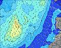 | 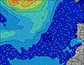 | 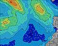 | 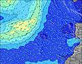 | ||||||||||||||
Wave Height (m) Direction Period (s) | SSW 12 | SSW 12 | SSW 12 | SSW 12 | SSW 12 | SSW 12 | SSW 13 | SSW 13 | SSW 12 | SSW 12 | SSW 12 | SSW 11 | SSW 11 | SSW 13 | SSW 13 | S 13 | SSW 12 | SSW 12 | S 12 | SSW 12 | SSW 11 |
Wave Graph | |||||||||||||||||||||
30 | 50 | 29 | 28 | 28 | 15 | 17 | 34 | 14 | 14 | 14 | 12 | 12 | 17 | 17 | 4 | 14 | 14 | 3 | 13 | 12 | |
Wind (km/h) | |||||||||||||||||||||
Wind State on-shore cross-onshore cross-shore cross-offshore off-shore glassy | cross-off | off | cross-off | cross-off | off | cross-off | cross-off | cross-off | cross-off | cross-off | cross-off | cross-off | cross-off | cross-off | cross-off | cross-off | cross-off | cross-off | cross-off | cross-off | off |
High Tide | 4:48PM1.90m | 5:15AM1.70m | 5:29PM1.79m | 6:01AM1.63m | 6:19PM1.66m | 6:59AM1.55m | 7:28PM1.53m | 8:17AM1.50m | 8:59PM1.46m | 9:47AM1.54m | 10:32PM1.51m | 11:06AM1.67m | 11:45PM1.63m | ||||||||
Low Tide | 10:31AM0.30m | 11:03PM0.26m | 11:12AM0.38m | 11:44PM0.34m | 12:00PM0.47m | 00:36AM0.45m | 1:05PM0.57m | 1:46AM0.55m | 2:34PM0.61m | 3:17AM0.58m | 4:13PM0.54m | 4:44AM0.52m | 5:32PM0.38m | ||||||||
7:26 | — | — | 7:26 | — | — | 7:26 | — | — | 7:28 | — | — | 7:28 | — | — | 7:28 | — | — | 7:28 | — | — | |
— | 8:51 | — | — | 8:50 | — | — | 8:49 | — | — | 8:47 | — | — | 8:47 | — | — | 8:46 | — | — | 8:45 | — | |
mm | — | — | — | — | — | — | — | — | — | — | — | — | — | — | — | — | — | — | — | — | — |
Temp °C | 33 | 33 | 32 | 34 | 34 | 32 | 31 | 32 | 29 | 30 | 30 | 28 | 31 | 32 | 28 | 31 | 33 | 29 | 28 | 29 | 25 |
Feels °C | 31 | 31 | 30 | 32 | 32 | 30 | 29 | 30 | 27 | 30 | 30 | 26 | 29 | 30 | 26 | 29 | 31 | 27 | 28 | 30 | 25 |
Swell 1 Height (m) Direction Period (s) | SSW 12 | SSW 12 | SSW 12 | SSW 12 | SSW 12 | SSW 12 | SSW 13 | E 6 | SSW 12 | SSW 12 | ENE 7 | SSW 11 | SSW 11 | SSW 11 | SSW 11 | SW 11 | SSW 12 | SSW 12 | S 10 | SSW 12 | SSW 11 |
30 | 50 | 29 | 28 | 28 | 15 | 17 | 5 | 14 | 14 | 17 | 12 | 12 | 12 | 11 | 4 | 14 | 14 | 2 | 13 | 12 | |
Swell 2 Height (m) Direction Period (s) | WNW 9 | WNW 9 | SSW 16 | E 5 | E 6 | SSW 9 | SSW 11 | SSW 13 | WNW 10 | ENE 7 | SSW 12 | WNW 9 | NW 9 | SSW 13 | SSW 13 | NW 9 | NW 8 | NW 8 | S 12 | W 8 | W 8 |
8 | 8 | 25 | 4 | 3 | 8 | 11 | 34 | 10 | 5 | 14 | 9 | 3 | 17 | 17 | 3 | 3 | 3 | 3 | 1 | 1 | |
Swell 3 Height (m) Direction Period (s) | S 18 | S 18 | WNW 9 | E 8 | SSW 15 | WNW 10 | WNW 10 | ENE 8 | S 8 | WNW 10 | WNW 10 | S 15 | S 14 | NW 9 | NW 9 | S 13 | W 8 | S 10 | W 8 | — | W 8 |
6 | 6 | 8 | 4 | 21 | 10 | 10 | 12 | 1 | 9 | 9 | 4 | 4 | 3 | 3 | 3 | 1 | 2 | 1 | — | 1 | |
Wind waves Height (m) Direction Period (s) | N 4 | NNE 4 | N 4 | N 4 | NNE 4 | NNE 4 | NNE 4 | NNE 4 | NNE 4 | NNE 4 | N 4 | NNE 4 | NNE 4 | NNE 4 | N 4 | N 5 | N 4 | N 4 | N 4 | N 4 | N 4 |
24 | 15 | 36 | 13 | 24 | 45 | 50 | 24 | 34 | 31 | 15 | 29 | 28 | 29 | 44 | 60 | 48 | 48 | 21 | 13 | 13 | |
Nearest Offshore or Glassy | |||||||||||||||||||||
Distance (km) | 97 | 100 | 110 | 109 | 97 | 97 | 97 | 109 | 97 | 97 | 97 | 97 | 97 | 97 | 109 | 564 | 109 | 98 | 97 | 97 | 97 |
Best forecast wave conditions in Gran Canaria | |||||||||||||||||||||
Best forecast wave conditions in Spain (Africa) | |||||||||||||||||||||
Header Global | |||||||||||||||||||||
- Map Icons:
 Break
Break Live Wave Height (m)
 Live Wind Speed (km/h)
 Surf Rating (10 Max)
 Ocean Swells (m)
- Wind Speed (km/h)
Latest Updates


FREE! Surf-Forecast.com widget for your website
The surf report / weather widget below is available to embed on third party websites free of charge and provides a summary of our Arguineguin surf forecast. Simply grab the html code snippet that we provide and paste it into your own site. You can choose your preferred language and metric/imperial units for the surf forecast feed to suit users of your site. Click here to get the code.
Information about the Arguineguin Surf forecast
The above surf forecast table for Arguineguin provides essential information for determining whether the surfing conditions will be good over the next 16 days. A general guide to surfing at Arguineguin can be found by selecting the local surf guide option on the grey menu. Our Arguineguin surf forecast is unique since it includes wave energy (power) that defines the real feel of the surf rather than just the height or the period. If you surf the same spot (Arguineguin) regularly then make a mental note of the wave energy from the surf forecast table each time you go. Very soon you may start to choose your surf days based on the wave energy alone combined with our forecast of favourable offshore wind conditions. Our star ratings will help here and of course you will also find the usual wave height and period predictions on our surf forecasts as well as a full break down of the swell components under our advanced users option (to reveal that, click the little Einstein character under the tide times).
Further information to help with frequently asked questions about our surf forecast for Arguineguin may be found under the help tab on the top menu and also by moving your mouse over the question marks on the surf forecast table itself. Please always bear in mind that the forecast is for near-shore open water and local factors at each surf break influence the actual breaking wave height, such as the beach / reef profile, water depths offshore and shelter.
Are you planning a holiday in Gran Canaria? If you are looking for accommodation near Arguineguin, camping, hotels and holiday cottages in Gran Canaria, consider staying in Playa del Ingles which is 10 km (6 miles) away. Other places in and around Gran Canaria where you can find information about places to rent, and car hire include Mogan which is 15 km (9 miles) away, San Bartolome, Santa Lucia and Aguimes.
 Nearest