

Surf Forecasts:

Maspalomas surf forecast from 3 Aug 2026:
- Most powerful swell: Monday 3 Aug, 7AM (local time) - 1ft (0.3m), 12s period, SSW swell with 30 kJ wave energy.
Best Forecast Surf Conditions for Maspalomas this week:
The most powerful waves expected at Maspalomas in the next 16 days are 0.3m 12s and forecast to arrive on Monday (Aug 03) at 7AM. Winds are predicted to be cross-offshore at the time the swell arrives. The largest open ocean swell (not directed at the beach) is 1.2m 7s period and expected on Wednesday (Aug 05) at 7AM.
| Wave Type | Time (WEST) & Date | Wave Height & Period |
|---|---|---|
| Next good surf (1 star+) | - | - |
| Best Surf | - | - |
| Most Powerful | 7AM (Mon 3rd Aug) | 1ft (0.3m) 12s |
Table - best surf conditions forecast for Maspalomas over the next 16 days.
The Lowdown
Alright folks, Rusty here. Let’s be straight with you—this outlook for the next couple of weeks is pretty grim. We’re looking at a long dry spell with barely a ripple worth paddling for. The first real chance of anything vaguely surfable doesn’t show up until mid-month, so you’ll want to keep the boards in the van for a while.
The whole period kicks off with a whole lot of nothing. From now through to the 13th of August, it’s flat to tiny. We’re talking waves around 0.3 ft to 1.0 ft with weak combined swell energy (mostly between 6 and 40). The wind is mostly offshore or cross-offshore, which would be great if there was any swell, but there isn’t. It’s clean, but it’s empty. You could spend that time cleaning your wax collection.
The only break on the radar is Maspalomas, a beach and reef setup that’s inconsistent and rarely offers much. It’s exposed to the south, and the guidance says it loves a south swell, but we just aren’t getting one with any punch.
Now, the one true standout in this whole 16-day window arrives on Friday, August 14th. Finally, the combined swell energy kicks up to 81 (moderate energy) with a 1.0 ft SSW swell. The period is a very long 20 seconds, which is proper groundswell. That long period tends to hold up better at a reef like Maspalomas, making it more interesting than the beach. The wind is offshore all day, starting with a gentle breeze and building to a moderate breeze, so it should be clean. It’s still not big, but it’s the best we’re going to get. The Saturday morning on the 15th holds a little 1 ft SW swell with 16-second period and offshore wind, but the energy drops back to 72. Neither of these are going to have you calling in sick, but if you’re desperate, that Friday is your window.
Between the 14th and the end of the outlook, the swell fades back to tiny 0.7 ft to 1.0 ft slop, and the energy drops off a cliff again. It’s a long, flat run with very little hope.
Given the lack of any real size, and the fact that it’s a beach and reef setup, the conditions look more interesting for a kite session than a paddle session if the wind picks up.
Stay patient, and don’t bother checking the buoys. The forecast can change, but right now, it’s a waiting game.
Rusty.
Short Range ForecastMostly dry. Warm (max 34°C on Tue afternoon, min 26°C on Tue night). Mainly fresh winds. | Days 4-6 Weather SummaryMostly dry. Warm (max 32°C on Sat afternoon, min 24°C on Wed night). Wind will be generally light. | ||||||||||||||||||||
Monday 3 | Tuesday 4 | Wednesday 5 | Thursday 6 | Friday 7 | Saturday 8 | Sunday 9 | |||||||||||||||
AM | PM | Night | AM | PM | Night | AM | PM | Night | AM | PM | Night | AM | PM | Night | AM | PM | Night | AM | PM | Night | |
Swell Height Map |  |  |  | 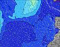 | 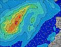 | 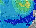 | 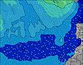 | ||||||||||||||
Wave Height (m) Direction Period (s) | SSW 12 | SSW 12 | SSW 16 | SSW 12 | SSW 15 | SSW 12 | SSW 13 | SSW 13 | SSW 12 | SSW 12 | SSW 12 | SSW 11 | SSW 11 | SSW 11 | SSW 11 | SW 10 | SW 12 | SW 12 | S 12 | SSW 12 | SSW 11 |
Wave Graph | |||||||||||||||||||||
30 | 30 | 25 | 28 | 21 | 13 | 17 | 17 | 14 | 14 | 14 | 12 | 12 | 12 | 11 | 4 | 6 | 6 | 4 | 13 | 12 | |
Wind (km/h) | |||||||||||||||||||||
Wind State on-shore cross-onshore cross-shore cross-offshore off-shore glassy | off | cross-off | cross-off | cross-off | cross-off | off | cross-off | cross-off | off | cross-off | cross-off | off | cross-off | off | off | off | cross-off | cross-off | cross-off | off | off |
High Tide | 4:38AM1.78m | 4:50PM1.92m | 5:17AM1.72m | 5:31PM1.81m | 6:03AM1.65m | 6:21PM1.67m | 7:01AM1.56m | 7:30PM1.55m | 8:19AM1.51m | 9:01PM1.48m | 9:49AM1.55m | 10:34PM1.53m | 11:07AM1.69m | 11:47PM1.65m | |||||||
Low Tide | 10:33AM0.30m | 11:04PM0.26m | 11:13AM0.38m | 11:46PM0.35m | 12:02PM0.47m | 00:38AM0.45m | 1:07PM0.57m | 1:48AM0.55m | 2:36PM0.61m | 3:19AM0.59m | 4:15PM0.54m | 4:45AM0.52m | 5:33PM0.38m | ||||||||
7:26 | — | — | 7:26 | — | — | 7:26 | — | — | 7:26 | — | — | 7:28 | — | — | 7:28 | — | — | 7:28 | — | — | |
— | 8:50 | — | — | 8:50 | — | — | 8:49 | — | — | 8:47 | — | — | 8:46 | — | — | 8:45 | — | — | 8:45 | — | |
mm | — | — | — | — | — | — | — | — | — | — | — | — | — | — | — | — | — | — | — | — | — |
Temp °C | 33 | 33 | 32 | 33 | 34 | 31 | 31 | 31 | 27 | 29 | 29 | 26 | 30 | 30 | 28 | 31 | 32 | 29 | 29 | 30 | 26 |
Feels °C | 29 | 29 | 27 | 29 | 30 | 27 | 27 | 27 | 24 | 28 | 26 | 24 | 28 | 29 | 26 | 28 | 29 | 26 | 27 | 29 | 24 |
Swell 1 Height (m) Direction Period (s) | SSW 12 | SSW 12 | SSW 12 | SSW 12 | SSW 12 | SSW 12 | SSW 13 | SSW 13 | SSW 12 | SSW 12 | SSW 12 | SSW 11 | SSW 11 | SSW 11 | SSW 11 | SW 10 | SW 12 | SW 12 | SW 10 | NE 7 | SSW 11 |
30 | 30 | 15 | 28 | 14 | 13 | 17 | 17 | 14 | 14 | 14 | 12 | 12 | 12 | 11 | 4 | 6 | 6 | 4 | 8 | 12 | |
Swell 2 Height (m) Direction Period (s) | E 8 | S 10 | SSW 10 | E 8 | SSW 15 | SW 14 | SW 9 | W 10 | W 10 | W 10 | W 10 | W 10 | W 9 | S 13 | SW 13 | W 9 | W 8 | S 10 | S 12 | SSW 12 | W 8 |
1 | 2 | 11 | 10 | 21 | 8 | 3 | 2 | 2 | 2 | 2 | 2 | 2 | 3 | 7 | 2 | 1 | 2 | 3 | 13 | 1 | |
Swell 3 Height (m) Direction Period (s) | S 18 | W 9 | SSW 16 | W 9 | S 9 | S 9 | W 10 | S 8 | S 8 | — | S 15 | S 15 | S 14 | W 9 | W 9 | S 8 | S 8 | W 8 | N 10 | N 10 | N 10 |
6 | 2 | 25 | 2 | 2 | 2 | 2 | 1 | 1 | — | 4 | 4 | 4 | 2 | 2 | 1 | 1 | 1 | 2 | 2 | 2 | |
Wind waves Height (m) Direction Period (s) | NNE 7 | NNE 7 | NE 6 | NE 6 | NE 7 | NE 7 | NE 7 | NE 7 | NE 7 | NE 7 | NE 7 | NE 7 | NNE 7 | NNE 8 | NNE 8 | NNE 8 | NNE 8 | NNE 8 | NNE 7 | NNE 6 | NE 6 |
68 | 81 | 94 | 79 | 88 | 100 | 116 | 119 | 119 | 135 | 127 | 104 | 93 | 72 | 103 | 92 | 103 | 89 | 41 | 24 | 39 | |
Nearest Offshore or Glassy | |||||||||||||||||||||
Distance (km) | 103 | 108 | 104 | 103 | 116 | 117 | 103 | 103 | 103 | 103 | 103 | 103 | 20 | 20 | 568 | 118 | 103 | 568 | 132 | 103 | 214 |
Best forecast wave conditions in Gran Canaria | |||||||||||||||||||||
Best forecast wave conditions in Spain (Africa) | |||||||||||||||||||||
Header Global | |||||||||||||||||||||
- Map Icons:
 Break
Break Live Wave Height (m)
 Live Wind Speed (km/h)
 Surf Rating (10 Max)
 Ocean Swells (m)
- Wind Speed (km/h)
Latest Updates


FREE! Surf-Forecast.com widget for your website
The surf report / weather widget below is available to embed on third party websites free of charge and provides a summary of our Maspalomas surf forecast. Simply grab the html code snippet that we provide and paste it into your own site. You can choose your preferred language and metric/imperial units for the surf forecast feed to suit users of your site. Click here to get the code.
Information about the Maspalomas Surf forecast
The above surf forecast table for Maspalomas provides essential information for determining whether the surfing conditions will be good over the next 16 days. A general guide to surfing at Maspalomas can be found by selecting the local surf guide option on the grey menu. Our Maspalomas surf forecast is unique since it includes wave energy (power) that defines the real feel of the surf rather than just the height or the period. If you surf the same spot (Maspalomas) regularly then make a mental note of the wave energy from the surf forecast table each time you go. Very soon you may start to choose your surf days based on the wave energy alone combined with our forecast of favourable offshore wind conditions. Our star ratings will help here and of course you will also find the usual wave height and period predictions on our surf forecasts as well as a full break down of the swell components under our advanced users option (to reveal that, click the little Einstein character under the tide times).
Further information to help with frequently asked questions about our surf forecast for Maspalomas may be found under the help tab on the top menu and also by moving your mouse over the question marks on the surf forecast table itself. Please always bear in mind that the forecast is for near-shore open water and local factors at each surf break influence the actual breaking wave height, such as the beach / reef profile, water depths offshore and shelter.
Are you planning a holiday in Gran Canaria? If you are looking for accommodation near Maspalomas, camping, hotels and holiday cottages in Gran Canaria, consider staying in Playa del Ingles which is 3 km (2 miles) away. Other places in and around Gran Canaria where you can find information about places to rent, and car hire include Santa Lucia which is 20 km (12 miles) away, Mogan, San Bartolome and Aguimes.
 Nearest