

Surf Forecasts:

El Conquistador surf forecast from 3 Aug 2026:
- Best quality surf: Monday 3 Aug, 4AM (local time) - 1.5ft (0.4m), 12s period, SSW swell with glassy winds.
- Most powerful swell: Monday 3 Aug, 1PM (local time) - 1.5ft (0.5m), 12s period, S swell with 77 kJ wave energy.
- Next surfable swell (1★+): Monday 3 Aug, 4AM (local time) - 1.5ft (0.4m), 12s period with SSW swell.
Best Forecast Surf Conditions for El Conquistador this week:
The surf forecast for El Conquistador over the next 16 days: The first swell (rated 1 star or higher) is forecast to arrive on Monday (Aug 03) at 4AM. The primary swell is predicted to be 0.4m and 12s period. The wind is predicted to be glassy as the swell arrives.
The most powerful waves expected at El Conquistador in the next 16 days are 0.5m 12s and forecast to arrive on Monday (Aug 03) at 1PM. Winds are predicted to be cross-onshore at the time the swell arrives. The largest open ocean swell (not directed at the beach) is 1.8m 6s period and expected on Wednesday (Aug 05) at 4PM.
| Wave Type | Time (WEST) & Date | Wave Height & Period |
|---|---|---|
| Next good surf (1 star+) | 4AM (Mon 3rd Aug) | 1.5ft (0.4m) 12s |
| Best Surf | 4AM (Mon 3rd Aug) | 1.5ft (0.4m) 12s |
| Most Powerful | 1PM (Mon 3rd Aug) | 1.5ft (0.5m) 12s |
Table - best surf conditions forecast for El Conquistador over the next 16 days.
The Lowdown
Alright folks, Rusty here. Let’s have a look at what’s on the cards for the next couple of weeks.
Right off the bat, I gotta be straight with you – it’s a pretty quiet stretch ahead. The first real surfable day kicks off on Monday, August 3rd, at El Conquistador, but even then it’s super small. We’re talking tiny waves with a combined swell energy of just 66. The morning has a glassy 1 ft from the SSW with a decent 12-second period, which is a long period groundswell, so it’ll have some push but the shape might be a bit too straight for this beach-and-reef setup. The water temp is about average for this time of year, nothing wild there.
That afternoon, the wind goes a bit cross-on and the swell drops to 2 ft with only 98 energy units – it’s just not doing much. Tuesday the 4th and Wednesday the 5th are more of the same: small 1.0 ft to 1 ft SSW swells, clean but tiny. The energy is weak, sitting in the 60s and 70s. Honestly, for the first week, you’re looking at a bit of a lull. There’s nothing that stands out as a real wave.
Then we go into a real dry spell. From Thursday the 6th all the way through to Tuesday the 11th of August, the energy drops into the teens and single digits. The swell is barely a ripple, and the combined energy readings are pitiful – 17, 15, 7. It’s flat, plain and simple. That’s a solid six-day gap with nothing to recommend.
We finally see a little bump on Wednesday the 12th. The morning is a mess with a light cross-onshore wind, but the afternoon at El Conquistador goes glassy with a 2 ft swell from the NW. Energy creeps up to 82, which is still weak, but it’s the best we’ve seen in a week. The swell period is a short 9 seconds though, so it’ll be a bit choppy and weak. Not exactly a standout, but it’s something to paddle out for if you’re desperate.
The rest of that week is more of the same tiny stuff. A glassy 1 ft on Thursday the 13th with a long 13-second period, but the energy is only 60. It’s surfable but very ordinary. Friday the 14th is similar.
Now, here’s the one thing that might get your attention. On Saturday the 15th and Sunday the 16th, we get a very long period SSW groundswell – 18 seconds on Saturday, 16 seconds on Sunday. The wave height is still only 1.0 ft, so it’s small, but the energy is around 65 and 53. With a period that long, the waves will have real shape and power, but at a beach break like this, it might break too straight. The winds are clean and cross-off, so it’ll be nice to look at. For a small-wave surfer who wants a long, clean glide, that Saturday morning could be the pick of the bunch. But don’t expect any barrels.
The run fades out again after that. Monday the 17th and Tuesday the 18th are back to 0.7 ft with poor conditions. The whole 16-day window is a pretty flat stretch overall. The best I can say is keep an eye on that Saturday the 15th – it’s the only one that hints at something promising, but it’s a long way off, so don’t hold your breath.
Rusty.
Short Range ForecastMostly dry. Warm (max 31°C on Mon morning, min 27°C on Sun night). Wind will be generally light. | Days 4-6 Weather SummaryMostly dry. Warm (max 28°C on Wed night, min 24°C on Thu night). Wind will be generally light. | ||||||||||||||||||||
Monday 3 | Tuesday 4 | Wednesday 5 | Thursday 6 | Friday 7 | Saturday 8 | Sunday 9 | |||||||||||||||
AM | PM | Night | AM | PM | Night | AM | PM | Night | AM | PM | Night | AM | PM | Night | AM | PM | Night | AM | PM | Night | |
Swell Height Map |  |  |  | 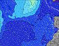 | 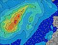 | 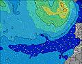 | 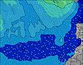 | ||||||||||||||
Wave Height (m) Direction Period (s) | SSW 12 | S 12 | SSW 12 | SSW 12 | SSW 14 | SSW 14 | NW 11 | NW 10 | NW 10 | NW 10 | WNW 9 | WNW 9 | SSW 11 | WNW 9 | WNW 9 | WNW 8 | SSW 12 | SSW 12 | S 12 | SSW 12 | SSW 11 |
Wave Graph | |||||||||||||||||||||
50 | 77 | 50 | 47 | 41 | 40 | 34 | 34 | 29 | 29 | 17 | 17 | 24 | 16 | 15 | 14 | 30 | 29 | 11 | 27 | 12 | |
Wind (km/h) | |||||||||||||||||||||
Wind State on-shore cross-onshore cross-shore cross-offshore off-shore glassy | glassy | cross-on | cross-off | cross-off | cross-off | cross-off | cross-off | glassy | cross-off | glassy | glassy | off | glassy | cross | cross-on | glassy | glassy | glassy | cross-off | glassy | glassy |
High Tide | 4:36AM1.65m | 4:48PM1.79m | 5:15AM1.60m | 5:28PM1.69m | 6:01AM1.53m | 6:19PM1.56m | 6:59AM1.45m | 7:27PM1.44m | 8:17AM1.41m | 8:58PM1.38m | 9:48AM1.45m | 10:32PM1.42m | 11:06AM1.58m | 11:45PM1.54m | |||||||
Low Tide | 10:31AM0.28m | 11:03PM0.24m | 11:11AM0.36m | 11:44PM0.32m | 12:00PM0.45m | 00:36AM0.42m | 1:05PM0.54m | 1:46AM0.52m | 2:35PM0.58m | 3:17AM0.55m | 4:14PM0.51m | 4:44AM0.48m | 5:32PM0.36m | ||||||||
7:30 | — | — | 7:30 | — | — | 7:31 | — | — | 7:31 | — | — | 7:31 | — | — | 7:31 | — | — | 7:33 | — | — | |
— | 8:54 | — | — | 8:54 | — | — | 8:53 | — | — | 8:52 | — | — | 8:52 | — | — | 8:52 | — | — | 8:51 | — | |
mm | — | — | — | — | — | — | — | — | — | — | — | — | — | — | — | — | — | — | — | — | — |
Temp °C | 31 | 30 | 30 | 30 | 31 | 31 | 30 | 29 | 28 | 27 | 28 | 24 | 26 | 26 | 26 | 27 | 26 | 25 | 26 | 25 | 24 |
Feels °C | 31 | 31 | 29 | 29 | 32 | 30 | 31 | 31 | 29 | 27 | 30 | 25 | 27 | 27 | 26 | 28 | 28 | 26 | 27 | 28 | 26 |
Swell 1 Height (m) Direction Period (s) | ENE 5 | ENE 6 | NW 9 | SSW 12 | ENE 6 | SSW 14 | NW 11 | ENE 6 | NW 10 | NW 10 | ENE 6 | ENE 8 | ENE 8 | ENE 7 | ENE 7 | ENE 6 | ENE 6 | SSW 12 | ENE 7 | ENE 5 | ENE 6 |
12 | 60 | 30 | 47 | 71 | 40 | 29 | 127 | 24 | 24 | 85 | 63 | 35 | 43 | 31 | 15 | 12 | 29 | 9 | 13 | 24 | |
Swell 2 Height (m) Direction Period (s) | SSW 12 | S 12 | SSW 12 | NW 9 | SSW 14 | NW 8 | SSW 13 | NW 10 | SSW 12 | SSW 12 | WNW 9 | WNW 9 | WNW 9 | WNW 9 | NW 5 | WNW 8 | NW 4 | NW 4 | WNW 8 | SSW 12 | NW 4 |
50 | 77 | 49 | 20 | 41 | 10 | 34 | 27 | 29 | 29 | 17 | 17 | 16 | 16 | 3 | 14 | 6 | 3 | 6 | 27 | 2 | |
Swell 3 Height (m) Direction Period (s) | WNW 9 | NW 9 | SSW 16 | NW 4 | SSW 12 | WNW 10 | SSW 11 | SSW 13 | NNW 5 | NW 5 | NW 5 | NW 5 | SSW 11 | NW 5 | WNW 9 | NW 4 | SSW 12 | WNW 8 | S 12 | NW 4 | SSW 11 |
16 | 21 | 50 | 1 | 27 | 10 | 12 | 34 | 2 | 3 | 6 | 4 | 24 | 4 | 15 | 3 | 30 | 6 | 11 | 2 | 12 | |
Wind waves Height (m) Direction Period (s) | NE 5 | NE 6 | ENE 5 | ENE 6 | NE 6 | ENE 5 | ENE 6 | NE 6 | ENE 6 | ENE 6 | NE 6 | NE 8 | NE 8 | NE 6 | NE 8 | NE 6 | — | ENE 6 | NE 5 | ENE 5 | NE 6 |
44 | 155 | 33 | 93 | 150 | 46 | 154 | 231 | 79 | 85 | 245 | 147 | 113 | 175 | 94 | 60 | — | 13 | 13 | 40 | 59 | |
Nearest Offshore or Glassy | |||||||||||||||||||||
Distance (km) | 0 | 2 | 0 | 0 | 0 | 69 | 0 | 0 | 0 | 0 | 79 | 1 | 0 | 19 | 515 | 1 | 19 | 515 | 19 | 19 | 299 |
Best forecast wave conditions in Tenerife | |||||||||||||||||||||
Best forecast wave conditions in Spain (Africa) | |||||||||||||||||||||
Header Global | |||||||||||||||||||||
- Map Icons:
 Break
Break Live Wave Height (m)
 Live Wind Speed (km/h)
 Surf Rating (10 Max)
 Ocean Swells (m)
- Wind Speed (km/h)
Latest Updates


FREE! Surf-Forecast.com widget for your website
The surf report / weather widget below is available to embed on third party websites free of charge and provides a summary of our El Conquistador surf forecast. Simply grab the html code snippet that we provide and paste it into your own site. You can choose your preferred language and metric/imperial units for the surf forecast feed to suit users of your site. Click here to get the code.
Information about the El Conquistador Surf forecast
The above surf forecast table for El Conquistador provides essential information for determining whether the surfing conditions will be good over the next 16 days. A general guide to surfing at El Conquistador can be found by selecting the local surf guide option on the grey menu. Our El Conquistador surf forecast is unique since it includes wave energy (power) that defines the real feel of the surf rather than just the height or the period. If you surf the same spot (El Conquistador) regularly then make a mental note of the wave energy from the surf forecast table each time you go. Very soon you may start to choose your surf days based on the wave energy alone combined with our forecast of favourable offshore wind conditions. Our star ratings will help here and of course you will also find the usual wave height and period predictions on our surf forecasts as well as a full break down of the swell components under our advanced users option (to reveal that, click the little Einstein character under the tide times).
Further information to help with frequently asked questions about our surf forecast for El Conquistador may be found under the help tab on the top menu and also by moving your mouse over the question marks on the surf forecast table itself. Please always bear in mind that the forecast is for near-shore open water and local factors at each surf break influence the actual breaking wave height, such as the beach / reef profile, water depths offshore and shelter.
Are you planning a holiday in Tenerife? If you are looking for accommodation near El Conquistador, camping, hotels and holiday cottages in Tenerife, consider staying in Arona which is 7 km (4 miles) away. Other places in and around Tenerife where you can find information about places to rent, and car hire include Adeje which is 8 km (5 miles) away, San Miguel, Tenerife and Granadilla de Abona.
 Nearest