

Surf Forecasts:

Playa de las Americas surf forecast from 1 Aug 2026:
- Best quality surf: Sunday 2 Aug, 1AM (local time) - 1ft (0.3m), 15s period, SSW swell with glassy winds.
- Most powerful swell: Sunday 2 Aug, 1PM (local time) - 1.5ft (0.5m), 13s period, S swell with 90 kJ wave energy.
- Next surfable swell (1★+): Sunday 2 Aug, 1AM (local time) - 1ft (0.3m), 15s period with SSW swell.
Best Forecast Surf Conditions for Playa de las Americas this week:
The surf forecast for Playa de las Americas over the next 16 days: The first swell (rated 1 star or higher) is forecast to arrive on Sunday (Aug 02) at 1AM. The primary swell is predicted to be 0.3m and 15s period with a secondary swell of 0.4m and 9s. The wind is predicted to be glassy as the swell arrives.
The most powerful waves expected at Playa de las Americas in the next 16 days are 0.5m 13s and forecast to arrive on Sunday (Aug 02) at 1PM. Winds are predicted to be cross-onshore at the time the swell arrives. The largest open ocean swell (not directed at the beach) is 1.6m 6s period and expected on Tuesday (Aug 04) at 1PM.
| Wave Type | Time (WEST) & Date | Wave Height & Period |
|---|---|---|
| Next good surf (1 star+) | 1AM (Sun 2nd Aug) | 1ft (0.3m) 15s |
| Best Surf | 1AM (Sun 2nd Aug) | 1ft (0.3m) 15s |
| Most Powerful | 1PM (Sun 2nd Aug) | 1.5ft (0.5m) 13s |
Table - best surf conditions forecast for Playa de las Americas over the next 16 days.
The Lowdown
Alright folks, this is Rusty. Let's have a look at what's on the menu for Playa de las Americas over the next couple of weeks.
Honestly, this is a pretty quiet stretch. We're looking at a long run of small, ordinary waves with very little to get excited about. The water temp is sitting at 73°, which is about average for this time of year, so no surprises there.
The first real chance to get wet comes in on Saturday afternoon, August 1st. The swell is tiny, only 1.0ft from the SSW, but the period is a long 15 seconds, which gives it a bit of life. The wind is glassy, making it clean. It's not going to blow your mind, but you can get a few small ones. The combined swell energy is weak (83).
The next few days are a real grind. From Sunday the 2nd right through to the end of the first week, we're stuck with that same story: small waves, mostly 1.0ft to 2ft, often with cross or onshore winds. You'll get some clean windows, like Monday morning the 3rd with offshore ESE wind on a 1ft SSW swell, or Thursday afternoon the 6th with glassy conditions on a 1.0ft SSW swell, but it's all very ordinary.
The best of a weak bunch looks like Tuesday morning, August 11th and Wednesday afternoon, August 12th. On Tuesday the 11th, we see a 1ft WNW swell with offshore ESE wind, giving clean conditions. Wednesday the 12th bumps up to a 2ft WNW swell with cross-offshore SSE wind. The combined energy nudges up to 72, still weak, but it's the most we've seen. Even then, it's barely a ripple.
There's a longer period swell showing up on the very last day, Sunday the 16th of August. A 1.0ft SSW swell with a very long 21-second period, and glassy conditions in the morning. The combined energy is 91. It's a promising sign, but it's far out and the swell height is tiny. This one is a long shot.
So, to be straight with you, there's no standout session in this whole 16-day window. The best bet is to keep an eye on that Sunday 16th for a possible glassy morning, but don't plan your life around it. The waves are just too small and weak for any real quality.
This is Rusty, signing off.
Short Range ForecastMostly dry. Warm (max 31°C on Sun afternoon, min 26°C on Sat night). Wind will be generally light. | Days 5-7 Weather SummaryMostly dry. Warm (max 30°C on Tue afternoon, min 24°C on Thu night). Wind will be generally light. | |||||||||||||||||||
Sat 1 | Sunday 2 | Monday 3 | Tuesday 4 | Wednesday 5 | Thursday 6 | Friday 7 | ||||||||||||||
PM | Night | AM | PM | Night | AM | PM | Night | AM | PM | Night | AM | PM | Night | AM | PM | Night | AM | PM | Night | |
Swell Height Map |  |  |  | 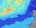 | 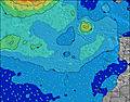 | 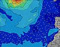 | 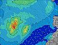 | |||||||||||||
Wave Height (m) Direction Period (s) | NW 9 | SSW 15 | SSW 13 | S 13 | SSW 13 | SSW 12 | S 12 | SSW 12 | SSW 12 | SSW 14 | SSW 14 | SSW 13 | SSW 13 | NW 10 | NW 10 | NW 9 | NW 9 | SSW 11 | WNW 9 | WNW 9 |
Wave Graph | ||||||||||||||||||||
42 | 42 | 59 | 90 | 55 | 50 | 77 | 49 | 47 | 41 | 40 | 34 | 57 | 29 | 29 | 28 | 25 | 24 | 16 | 15 | |
Wind (km/h) | ||||||||||||||||||||
Wind State on-shore cross-onshore cross-shore cross-offshore off-shore glassy | cross-off | glassy | glassy | cross-on | cross-off | cross | cross-on | cross-off | cross-off | glassy | cross-off | off | off | off | off | cross-off | off | glassy | glassy | cross-off |
High Tide | 4:01AM1.68m | 4:13PM1.87m | 4:36AM1.65m | 4:48PM1.79m | 5:15AM1.60m | 5:28PM1.69m | 6:01AM1.53m | 6:19PM1.56m | 6:59AM1.45m | 7:27PM1.44m | 8:17AM1.41m | 8:58PM1.38m | ||||||||
Low Tide | 9:54PM0.16m | 9:55AM0.23m | 10:27PM0.19m | 10:31AM0.28m | 11:03PM0.24m | 11:11AM0.36m | 11:44PM0.32m | 12:00PM0.45m | 00:36AM0.42m | 1:05PM0.54m | 1:46AM0.52m | 2:35PM0.58m | 3:17AM0.55m | |||||||
— | — | 7:28 | — | — | 7:30 | — | — | 7:30 | — | — | 7:31 | — | — | 7:31 | — | — | 7:31 | — | — | |
8:57 | — | — | 8:55 | — | — | 8:54 | — | — | 8:54 | — | — | 8:53 | — | — | 8:52 | — | — | 8:52 | — | |
mm | — | — | — | — | — | — | — | — | — | — | — | — | — | — | — | — | — | — | — | — |
Temp °C | 27 | 27 | 29 | 31 | 28 | 30 | 30 | 28 | 29 | 30 | 28 | 29 | 28 | 26 | 26 | 26 | 25 | 26 | 27 | 26 |
Feels °C | 29 | 28 | 29 | 31 | 28 | 31 | 31 | 29 | 30 | 32 | 30 | 31 | 29 | 26 | 26 | 27 | 27 | 27 | 29 | 26 |
Swell 1 Height (m) Direction Period (s) | NW 9 | ENE 5 | ENE 4 | S 13 | ENE 6 | SSW 12 | ENE 5 | ENE 6 | SSW 12 | ENE 6 | ENE 6 | NW 9 | ENE 6 | ENE 6 | NW 10 | ENE 6 | ENE 7 | ENE 7 | ENE 6 | ENE 6 |
41 | 16 | 11 | 90 | 33 | 50 | 25 | 36 | 47 | 60 | 34 | 21 | 77 | 57 | 23 | 48 | 29 | 29 | 28 | 29 | |
Swell 2 Height (m) Direction Period (s) | NE 7 | WNW 9 | WNW 9 | WNW 10 | SSW 13 | NW 9 | S 12 | NW 9 | NW 9 | NW 9 | SSW 14 | SSW 13 | SSW 13 | NW 10 | SSW 12 | NW 9 | NW 9 | WNW 9 | WNW 9 | WNW 9 |
11 | 32 | 29 | 36 | 55 | 20 | 77 | 41 | 20 | 19 | 40 | 34 | 57 | 24 | 29 | 22 | 21 | 16 | 16 | 15 | |
Swell 3 Height (m) Direction Period (s) | SSW 15 | SSW 15 | SSW 13 | ENE 6 | NW 9 | NW 4 | NW 9 | SSW 12 | NW 4 | SSW 14 | NW 8 | SSW 11 | NW 10 | SSW 12 | NW 4 | SSW 12 | SSW 11 | SSW 11 | NW 4 | NW 4 |
42 | 42 | 59 | 7 | 22 | 1 | 21 | 49 | 1 | 41 | 10 | 12 | 24 | 29 | 3 | 28 | 25 | 24 | 3 | 3 | |
Wind waves Height (m) Direction Period (s) | ENE 4 | NE 6 | NE 5 | NE 6 | NE 6 | ENE 6 | NE 5 | NE 6 | ENE 6 | NE 6 | NE 6 | ENE 6 | NE 6 | NE 6 | ENE 6 | NE 6 | NE 7 | NE 6 | NE 6 | NE 6 |
7 | 146 | 73 | 29 | 77 | 42 | 82 | 104 | 90 | 111 | 101 | 85 | 126 | 114 | 37 | 98 | 91 | 68 | 102 | 72 | |
Nearest Offshore or Glassy | ||||||||||||||||||||
Distance (km) | 0 | 0 | 0 | 3 | 0 | 18 | 3 | 0 | 0 | 0 | 0 | 0 | 0 | 0 | 0 | 0 | 0 | 0 | 18 | 78 |
Best forecast wave conditions in Tenerife | ||||||||||||||||||||
Best forecast wave conditions in Spain (Africa) | ||||||||||||||||||||
Header Global | ||||||||||||||||||||
- Map Icons:
 Break
Break Live Wave Height (m)
 Live Wind Speed (km/h)
 Surf Rating (10 Max)
 Ocean Swells (m)
- Wind Speed (km/h)
Latest Updates


FREE! Surf-Forecast.com widget for your website
The surf report / weather widget below is available to embed on third party websites free of charge and provides a summary of our Playa de las Americas surf forecast. Simply grab the html code snippet that we provide and paste it into your own site. You can choose your preferred language and metric/imperial units for the surf forecast feed to suit users of your site. Click here to get the code.
Information about the Playa de las Americas Surf forecast
The above surf forecast table for Playa de las Americas provides essential information for determining whether the surfing conditions will be good over the next 16 days. A general guide to surfing at Playa de las Americas can be found by selecting the local surf guide option on the grey menu. Our Playa de las Americas surf forecast is unique since it includes wave energy (power) that defines the real feel of the surf rather than just the height or the period. If you surf the same spot (Playa de las Americas) regularly then make a mental note of the wave energy from the surf forecast table each time you go. Very soon you may start to choose your surf days based on the wave energy alone combined with our forecast of favourable offshore wind conditions. Our star ratings will help here and of course you will also find the usual wave height and period predictions on our surf forecasts as well as a full break down of the swell components under our advanced users option (to reveal that, click the little Einstein character under the tide times).
Further information to help with frequently asked questions about our surf forecast for Playa de las Americas may be found under the help tab on the top menu and also by moving your mouse over the question marks on the surf forecast table itself. Please always bear in mind that the forecast is for near-shore open water and local factors at each surf break influence the actual breaking wave height, such as the beach / reef profile, water depths offshore and shelter.
Playa de las Americas is 6 km (4 miles) from the city of Adeje. If you plan a holiday in Tenerife, look for hotels and other accommodation in Adeje. Adeje has rooms for a wide range of budgets as well as car hire and transport links.
 Nearest