

Surf Forecasts:

Igueste de San Andres surf forecast from 29 Jul 2026:
- Best quality surf: Thursday 30 Jul, 4AM (local time) - 4.5ft (1.4m), 6s period, NNE swell with offshore winds.
- Most powerful swell: Wednesday 5 Aug, 7AM (local time) - 6ft (1.9m), 7s period, NE swell with 392 kJ wave energy.
- Next surfable swell (1★+): Thursday 30 Jul, 4AM (local time) - 4.5ft (1.4m), 6s period with NNE swell.
Best Forecast Surf Conditions for Igueste de San Andres this week:
The surf forecast for Igueste de San Andres over the next 16 days: The first swell (rated 1 star or higher) is forecast to arrive on Thursday (Jul 30) at 4AM. The primary swell is predicted to be 1.4m and 6s period with a secondary swell of 0.1m and 10s. The wind is predicted to be offshore as the swell arrives.
The most powerful waves expected at Igueste de San Andres in the next 16 days are 1.9m 7s and forecast to arrive on Wednesday (Aug 05) at 7AM. Winds are predicted to be offshore at the time the swell arrives. The largest open ocean swell (not directed at the beach) is 1.6m 6s period and expected on Sunday (Aug 02) at 1PM.
| Wave Type | Time (WEST) & Date | Wave Height & Period |
|---|---|---|
| Next good surf (1 star+) | 4AM (Thu 30th Jul) | 4.5ft (1.4m) 6s |
| Best Surf | 4AM (Thu 30th Jul) | 4.5ft (1.4m) 6s |
| Most Powerful | 7AM (Wed 5th Aug) | 6ft (1.9m) 7s |
Table - best surf conditions forecast for Igueste de San Andres over the next 16 days.
The Lowdown
Alright folks, Rusty here. Let’s get into it.
Look, I’m not gonna lie to you – the next week and a half is a bit of a grind. We’ve got a persistent, moderate northeast wind that’s keeping things clean but the swell is just kinda… there. It’s not a total washout, but you’ll be working for it. The real story is waiting for us at the back end of the forecast, around the 10th of August, when things finally kick into gear.
We’re focusing on Igueste de San Andrés (Spain). Water temp is sitting about average for the time of year, nothing wild there.
The pattern starts Wednesday the 29th of July with a weak 4 ft northwest-northeast windswell, period a short 7 seconds, and the combined energy is a modest 132. It’s poor. Thursday the 30th is a step up, but just barely. By Thursday morning we’ve got 5 ft from the north-northeast (energy 212), and the wind is offshore. It’s surfable, but the conditions are ordinary. That theme runs right through the first weekend and into the start of the week. Friday the 31st sees 5 ft from the northeast, energy 276, still with that offshore breeze. Saturday the 1st of August drops a little to 4 ft, and Sunday the 2nd offers a 4 ft in the morning, but the wind goes cross-off, making it a bit bumpy. The afternoon cleans up again with a 4 ft from the north-northeast, energy 183. It’s a grind.
We get a bit of a bump on Tuesday the 4th of August, with 6 ft from the northeast, energy hitting 341. Still just ordinary, but the consistent offshore wind is a saving grace. Wednesday the 5th pushes up to 6 ft from the northeast, energy 392, and the conditions are still clean. The consistency is there, but the quality is just… average. This stretch of fairly consistent, clean but average surf runs right through to the 7th.
Then comes a drop. The 8th of August is a write-off, with tiny 2 ft, and the 9th is poor despite a 5 ft north-northeast swell, because the period drops to a terrible 6 seconds and the wind stiffens up.
Now, here’s where it gets interesting. Monday the 10th of August is the standout. We see a solid 8 ft swell from the north-northeast, with a period of 8 seconds. The combined energy jumps to a strong 606. That’s a proper push. The wind is offshore at 15 mph, so it’ll be clean. Now, at 8 ft, this is getting into the zone for strong intermediates only; beginners should sit this one out. The period is not super long, but it’s enough to hold the shape together. The afternoon on the 10th stays clean with a similar 8 ft, energy 654.
Tuesday the 11th of August keeps the pulse going, with another 7-8 ft from the north-northeast, and the energy peaks at 704. The afternoon session on the 11th is actually rated as “expect good surf conditions,” which is the best call we’ve seen all window. Again, wind is offshore and clean. This is the window to circle.
The swell starts to ease a touch on Wednesday the 12th, with 6 ft from the north-northeast, and the energy drops to 431. Still clean, but the power is fading. Thursday the 13th is back to ordinary, with 6 ft and energy 388.
So, to wrap it up: the first week is a slog of clean but average waist-to-chest high waves. The real prize is the 10th and 11th of August, when we get a solid head-high to slightly overhead northeast swell with good offshore wind. That’s your best bet. Don’t sleep on it.
Rusty.
Short Range ForecastMostly dry. Warm (max 22°C on Thu afternoon, min 20°C on Tue night). Wind will be generally light. | Days 4-6 Weather SummaryMostly dry. Warm (max 23°C on Sat morning, min 21°C on Fri night). Wind will be generally light. | ||||||||||||||||||||
Wednesday 29 | Thursday 30 | Friday 31 | Saturday 1 | Sunday 2 | Monday 3 | Tuesday 4 | |||||||||||||||
AM | PM | Night | AM | PM | Night | AM | PM | Night | AM | PM | Night | AM | PM | Night | AM | PM | Night | AM | PM | Night | |
Swell Height Map |  |  |  | 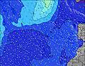 | 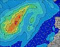 | 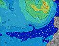 | 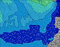 | ||||||||||||||
Wave Height (m) Direction Period (s) | NNE 7 | N 9 | NNE 6 | NNE 7 | NE 7 | NE 7 | NE 7 | NE 7 | NE 7 | NNE 7 | NNE 7 | NNE 7 | NNE 7 | NNE 7 | N 7 | NE 7 | NE 7 | NE 8 | NE 7 | NE 8 | NE 8 |
Wave Graph | |||||||||||||||||||||
110 | 13 | 136 | 205 | 227 | 247 | 247 | 229 | 242 | 178 | 197 | 113 | 121 | 149 | 123 | 112 | 122 | 164 | 327 | 318 | 320 | |
Wind (km/h) | |||||||||||||||||||||
Wind State on-shore cross-onshore cross-shore cross-offshore off-shore glassy | off | cross-off | off | off | off | off | off | off | off | off | off | cross-off | cross-off | off | cross-off | off | off | off | off | off | off |
High Tide | 2:26PM2.02m | 2:45AM1.85m | 2:58PM2.09m | 3:17AM1.89m | 3:29PM2.12m | 3:49AM1.90m | 4:01PM2.12m | 4:22AM1.89m | 4:34PM2.07m | 4:57AM1.86m | 5:10PM1.99m | 5:36AM1.80m | 5:52PM1.88m | ||||||||
Low Tide | 8:09AM0.32m | 8:40PM0.24m | 8:41AM0.26m | 9:12PM0.20m | 9:13AM0.23m | 9:43PM0.18m | 9:44AM0.24m | 10:15PM0.19m | 10:17AM0.27m | 10:48PM0.22m | 10:53AM0.32m | 11:24PM0.29m | 11:34AM0.40m | 00:06AM0.37m | |||||||
7:24 | — | — | 7:24 | — | — | 7:24 | — | — | 7:24 | — | — | 7:26 | — | — | 7:26 | — | — | 7:26 | — | — | |
— | 8:57 | — | — | 8:55 | — | — | 8:55 | — | — | 8:54 | — | — | 8:53 | — | — | 8:53 | — | — | 8:52 | — | |
mm | — | — | — | — | — | — | — | — | — | — | — | — | — | — | — | — | — | — | — | — | — |
Temp °C | 21 | 21 | 20 | 21 | 22 | 21 | 22 | 22 | 21 | 23 | 23 | 22 | 23 | 23 | 23 | 23 | 23 | 22 | 22 | 23 | 22 |
Feels °C | 19 | 19 | 19 | 20 | 21 | 20 | 22 | 21 | 21 | 25 | 24 | 22 | 23 | 23 | 23 | 23 | 23 | 22 | 22 | 23 | 23 |
Swell 1 Height (m) Direction Period (s) | N 10 | N 9 | NW 10 | NW 10 | N 12 | N 11 | N 11 | NE 7 | NE 7 | NNE 7 | NW 9 | NNE 7 | NW 8 | NNE 7 | NE 7 | NE 7 | NE 7 | NE 8 | NE 7 | NE 8 | SSW 12 |
17 | 13 | 4 | 4 | 11 | 23 | 21 | 229 | 242 | 178 | 22 | 113 | 18 | 149 | 91 | 112 | 122 | 164 | 327 | 318 | 15 | |
Swell 2 Height (m) Direction Period (s) | NW 11 | NW 11 | N 11 | N 13 | NW 10 | NW 9 | NW 11 | N 11 | NW 10 | NW 10 | SSW 15 | N 9 | SSW 13 | ENE 6 | N 10 | N 9 | N 9 | N 9 | SSW 12 | SSW 12 | WNW 8 |
5 | 5 | 2 | 3 | 4 | 3 | 5 | 20 | 24 | 23 | 21 | 26 | 35 | 34 | 29 | 25 | 25 | 14 | 28 | 27 | 7 | |
Swell 3 Height (m) Direction Period (s) | S 9 | N 11 | S 9 | S 9 | S 9 | S 8 | NW 9 | NW 11 | N 10 | N 10 | S 11 | NW 9 | — | SSW 13 | SSW 13 | SSW 12 | SSW 12 | WNW 9 | N 9 | N 8 | WNW 10 |
2 | 3 | 2 | 1 | 1 | 1 | 3 | 18 | 31 | 29 | 3 | 21 | — | 59 | 34 | 29 | 30 | 8 | 14 | 13 | 10 | |
Wind waves Height (m) Direction Period (s) | NNE 7 | NNE 6 | NNE 6 | NNE 7 | NE 7 | NE 7 | NE 7 | — | — | — | NNE 7 | — | NNE 7 | — | N 7 | N 7 | N 6 | N 7 | — | — | NE 8 |
110 | 87 | 136 | 205 | 227 | 247 | 247 | — | — | — | 197 | — | 121 | — | 123 | 103 | 68 | 83 | — | — | 320 | |
Nearest Offshore or Glassy | |||||||||||||||||||||
Distance (km) | 79 | 655 | 78 | 0 | 0 | 0 | 0 | 0 | 0 | 0 | 0 | 77 | 78 | 0 | 4 | 0 | 0 | 0 | 0 | 0 | 0 |
Best forecast wave conditions in Tenerife | |||||||||||||||||||||
Best forecast wave conditions in Spain (Africa) | |||||||||||||||||||||
Header Global | |||||||||||||||||||||
- Map Icons:
 Break
Break Live Wave Height (m)
 Live Wind Speed (km/h)
 Surf Rating (10 Max)
 Ocean Swells (m)
- Wind Speed (km/h)


FREE! Surf-Forecast.com widget for your website
The surf report / weather widget below is available to embed on third party websites free of charge and provides a summary of our Igueste de San Andres surf forecast. Simply grab the html code snippet that we provide and paste it into your own site. You can choose your preferred language and metric/imperial units for the surf forecast feed to suit users of your site. Click here to get the code.
Information about the Igueste de San Andres Surf forecast
The above surf forecast table for Igueste de San Andres provides essential information for determining whether the surfing conditions will be good over the next 16 days. A general guide to surfing at Igueste de San Andres can be found by selecting the local surf guide option on the grey menu. Our Igueste de San Andres surf forecast is unique since it includes wave energy (power) that defines the real feel of the surf rather than just the height or the period. If you surf the same spot (Igueste de San Andres) regularly then make a mental note of the wave energy from the surf forecast table each time you go. Very soon you may start to choose your surf days based on the wave energy alone combined with our forecast of favourable offshore wind conditions. Our star ratings will help here and of course you will also find the usual wave height and period predictions on our surf forecasts as well as a full break down of the swell components under our advanced users option (to reveal that, click the little Einstein character under the tide times).
Further information to help with frequently asked questions about our surf forecast for Igueste de San Andres may be found under the help tab on the top menu and also by moving your mouse over the question marks on the surf forecast table itself. Please always bear in mind that the forecast is for near-shore open water and local factors at each surf break influence the actual breaking wave height, such as the beach / reef profile, water depths offshore and shelter.
Are you planning a holiday in Tenerife? If you are looking for accommodation near Igueste de San Andres, camping, hotels and holiday cottages in Tenerife, consider staying in Santa Cruz de Tenerife which is 13 km (8 miles) away. Other places in and around Tenerife where you can find information about places to rent, and car hire include Tenerife-Sur which is 14 km (9 miles) away, La Laguna, Tenerife-Norte and Tacoronte.
 Nearest